
Clearfield County is a sixth-class county located in the U.S. state of Pennsylvania. As of the 2010 census, the population was 81,642. The county seat is Clearfield, and the largest city is DuBois. The county was created in 1804 and later organized in 1822.

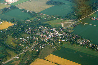
Cooper Township is a township in Clearfield County, Pennsylvania, United States. The population was 2,704 at the 2010 census.

Kingston Township is a township in Luzerne County, Pennsylvania, United States. The population was 6,999 at the 2010 census. The villages of Trucksville and Shavertown are located within the township. It is home to Frances Slocum State Park. The township is described as "the gateway to the Back Mountain". The area includes the townships of Dallas, Franklin, Jackson, Kingston, Lake, and Lehman. The region also includes the boroughs of Dallas and Harveys Lake.

Edwardsburgh/Cardinal is a township in the United Counties of Leeds and Grenville of eastern Ontario, Canada. Edwardsburgh township was first surveyed in 1783, and incorporated in 1850. The township was part of the historical Grenville County before it merged with Leeds County to form the United Counties in the 19th century.
Zorra is a township in Oxford County, situated in south-western Ontario, Canada. A predominantly rural municipality, Zorra was formed in 1975 through the amalgamation of East Nissouri, West Zorra and North Oxford townships. It is best known for the Highland Games weekend held each summer in Embro, celebrating the heritage of the Scottish pioneer families which grew from the 1830s to form nearly a quarter of the county's population.
Hikes Point is a neighborhood in eastern Louisville, Kentucky, USA. Its boundaries are I-264 to the north, Breckenridge Lane to the west, and irregular boundaries to the other sides.
New Milltown, Pennsylvania is a historic stone mill and unincorporated community located in Salisbury Township, Lancaster County, Pennsylvania.

Canaan is an unincorporated community and census-designated place (CDP) in Shelby Township, Jefferson County, Indiana, United States. As of the 2010 census it had a population of 90.
Big Cedar Baptist Church and Burying Ground is located on Big Cedar Creek Road, between the road to Reily and the Oxford Pike, in Springfield Township, Franklin County, Indiana. Big Cedar was an arm or branch of the Little Cedar Grove Baptist Church, which was the first church constituted in the Whitewater River Valley, by Elder William Tyner, who had come with colony from Virginia about 1797.

Richland Township is one of twelve townships in Steuben County, Indiana, United States. As of the 2010 census, its population was 570 and it contained 187 housing units, making it the smallest township in the county.

Hesston is a small unincorporated community in Penn Township of Huntingdon County, Pennsylvania. Also located in Hesston is Raystown Lake. Hesston is the home of the Hesston Speedway. Original called Pleasant Grove and Grafton but renamed Hesston.

The Old Eagle School is located near Strafford Station on the main line of the Pennsylvania Railroad in Tredyffrin Township, Chester County, Pennsylvania.

Sabin is an unincorporated community in the Town of Sylvan, Richland County, Wisconsin, United States. It is located at the intersection of County Highway E and Robbson Drive.

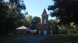
Rocky Spring Presbyterian Church is a historic Presbyterian church in Letterkenny Township, Franklin County, Pennsylvania. It was built in 1794, and is a 1 1/2-story, four by six bay, brick Georgian style building. It measures 48 feet by 60 feet, and has a gable roof. The interior of the church includes two ten-plate stoves; brick aisle ways; a crude ladder leading to a loft; and wooden pews that are long and narrow with high straight-backed seating. The ends of the pews are carved with the names of the previous occupants identifying the military ranks they held during the Revolutionary War. Rocky Springs Church was a pay for pew church that required members to sign a financial agreement between the trustees of the church and the pew holders requiring an annual fee for occupancy of the pew. The Church's pulpit is circular in form and positioned above the pews giving the speaker full view of the congregation. Access is gained by a staircase. Above the pulpit is an oval-shaped canopy or sounding board.

The Church of the Holy Apostles, Oneida, Wisconsin, United States, is a mission congregation of the Episcopal Diocese of Fond du Lac located on the Oneida Reservation of the Oneida Nation of Wisconsin.
Thyatira Presbyterian Church, Cemetery, and Manse is a historic church at 220 White Road off NC 150 in Mill Bridge in Rowan County, North Carolina, ten miles west of the town of Salisbury. Presbyterians have been worshiping at this site since at least 1753.

Drums is an unincorporated community in Butler Township, Luzerne County, Pennsylvania. Located about 1,500 feet (460 m) altitude in the Sugarloaf Valley, it sits east of Interstate 81 and north of Nescopeck Creek, a tributary of the Susquehanna River. It was founded by the Drum family in the late 18th century originally and was originally known as Drum's. Its ZIP Code is 18222, served by the 788 exchange in Area Code 570.

The Hess Homestead, in Lancaster County, Pennsylvania, is a historic Mennonite farmstead near the town of Lititz. The property is an ancestral home of the Hess family, who purchased the land from William Penn's sons in 1735.

York Chapel is a former United Methodist Church in Longtown, Missouri.
Briggsdale is a neighborhood of Franklin County in the city of Columbus, Ohio. The neighborhood is on the west/southwest side of the city within the Hilltop area. The area was first settled and founded by the family of Joseph M. Briggs, after whom the neighborhood was named. Joseph Briggs was an active figure in the early years of the township and county operations. The Briggsdale Methodist church was founded with his help, and it now exists as the New Horizons Methodist Church. The present day Briggsdale neighborhood is located near the historical Green Lawn Cemetery to the north as well as Briggs High School to the west.

