Colorado River Storage Project

Last updated
Map showing the locations of CRSP dams and participating projects. Colorado River Storage Project map.png
Map showing the locations of CRSP dams and participating projects.
Glen Canyon Dam and Lake Powell near Page, Arizona. The dam and lake are major components in the Colorado River Storage Project's attempt to regulate the flow of the Colorado River. Glen Canyon Dam Lake Powell, Arizona.JPG
Glen Canyon Dam and Lake Powell near Page, Arizona. The dam and lake are major components in the Colorado River Storage Project's attempt to regulate the flow of the Colorado River.

The Colorado River Storage Project is a United States Bureau of Reclamation project designed to oversee the development of the upper basin of the Colorado River. The project provides hydroelectric power, flood control and water storage for participating states along the upper portion of the Colorado River and its major tributaries. [1]

Contents

Since its inception in 1956, the project has grown to include the participation of several related water management projects throughout the river's basin. The project's original scope, and primary focus, are the upper Colorado River itself, the Green River, the San Juan River, and the Gunnison River.

Participating states are Arizona, Utah, New Mexico, Colorado and Wyoming.

History

Attempts at managing the water supply in the upper Colorado River basin were first recorded in 1854 at Fort Supply in Wyoming, when water was diverted from Blacks Fork to irrigate local lands. Subsequent diversions of the waters in the Colorado basin led to preliminary investigations of means to develop the system as early as 1902 when the Bureau of Reclamation, then known as the Reclamation Service, was established. [2]

Serious consideration for the project began when the Colorado River Compact was signed in 1922 by the participating states, as well as the lower Colorado River states, California and Nevada. As a stipulation of that compact, the upper basin states were required to ensure an annual flow of no less than 7,500,000 acre-feet (9.3 km3) be delivered to the lower basin states. [3] However, the annual flow of the Colorado River at Lee's Ferry in Arizona, the established dividing point, was extremely erratic, ranging from 4,000,000 acre-feet (4.9 km3) to 22,000,000 acre-feet (27 km3). This led to an inability of the upper basin states to meet the minimum delivery requirements to the lower states in dry years, and a loss of significant surpluses in wet years.

Lee's Ferry, Arizona, is the dividing point between the upper and lower Colorado River basins. Lee's Ferry.JPG
Lee's Ferry, Arizona, is the dividing point between the upper and lower Colorado River basins.

In order to regulate the flow of the Colorado and ensure compliance with the compact, a study was undertaken that determined a series of dams and reservoirs on the river and its tributaries would be necessary. A joint effort between the Upper Colorado River Commission, the Bureau of Reclamation and other federal agencies delivered a report with proposed projects to the United States Congress in 1950.

Among the proposed projects was a dam to be constructed on the Green River in Echo Park, in Dinosaur National Monument in Colorado. The proposal for Echo Park Dam created controversy and sparked the ire of Sierra Club director David Brower, who embarked on a national campaign to rescue the park. As part of a compromise, the proposed dam was stricken from the project and replaced with another dam in Glen Canyon, Arizona[ citation needed ]. Brower, who had not personally visited Glen Canyon prior to the compromise, later lamented the deal, describing it as "the worst mistake of his career" and "'the biggest sin I ever committed'". [4]

A revised, and slightly pared down, version of the plan was passed into law by Congress in 1956. The legislation called for the construction of dams, reservoirs and related works at Curecanti in Colorado, Flaming Gorge in Wyoming, Navajo in New Mexico and Glen Canyon in Arizona. All but the Navajo project were to include power generation capabilities; the Navajo project was intended as flood control only. Also included in the legislation were several related projects in the Colorado River basin. [5]

Project scope

The Colorado River Storage Project is made up of four separate units, spread along the upper Colorado basin and its major tributaries. Also included are several participating projects located throughout the system.

As a whole, the system provides a storage capacity of approximately 34,000,000 acre-feet (42 km3) of water. This capacity is released to meet the Colorado River Compact's delivery requirements during periods of low flow in the system. Additionally, three of the units provide hydroelectric power to major markets in the southwest. [1]

Lee's Ferry in Arizona serves as the southern boundary point for the project, which encompasses the Colorado River upstream from this point and all tributaries.

Glen Canyon Unit

Glen Canyon Dam, with Lake Powell in the background. Glencanyondam.jpg
Glen Canyon Dam, with Lake Powell in the background.

The Glen Canyon Unit, which consists of the Glen Canyon Dam, Lake Powell and the Glen Canyon Powerplant, is the largest and most important unit of the system. [1] While the dam is located near Page in northern Arizona, the majority of Lake Powell resides in southern Utah. With a total storage capacity of 27,000,000 acre-feet (33 km3) of water in Lake Powell, the Glen Canyon Unit accounts for over 64% of the system's overall water storage capacity. The 1,296 megawatt capacity of the dam's hydroelectric generators accounts for almost 75% of the overall generating capacity of the project. [6]

In spite of its importance to the system, the Glen Canyon Unit has also been the source of controversy even before it began operating in 1964. Sierra Club director David Brower, who was partially responsible for the location of the dam as part of a compromise, later regretted the decision. [4] Former Arizona Senator Barry Goldwater, who was a proponent of the dam in the beginning, later recanted his opinion and admitted that he, too, had regretted supporting the project. [7] Recent calls for the draining of Lake Powell and the restoration of Glen Canyon by environmental groups such as Sierra Club have resulted in the founding of several advocacy groups for the cause such as Living Rivers and Friends of Glen Canyon, as well as opposition groups such as Friends of Lake Powell.

Glen Canyon Bridge Glen Dam bridge.JPG
Glen Canyon Bridge

Given the importance of the unit to the project as well as its impact as a tourist destination to the region, restoration efforts face significant opposition and there currently exist no plans to cease operations at Glen Canyon.

Not directly a part of the project but built as a direct result of it, the Glen Canyon Dam Bridge was constructed over the river in 1959. At the time of its completion it was the highest arch bridge in the world. [1] It currently serves as one of only two bridges to cross the Colorado River between Lake Mead and Lake Powell, carrying the majority of the traffic between northern Arizona and southern Utah.

Flaming Gorge Unit

Flaming Gorge Dam and reservoir from the air. Flaming Gorge dam.jpg
Flaming Gorge Dam and reservoir from the air.

The Flaming Gorge Unit consists of the Flaming Gorge Dam and the Flaming Gorge Reservoir, and the dam's powerplant. The dam impounds the Green River near Dutch John, Utah. Portions of the reservoir spill over into Southern Wyoming near the city of Green River.

Completed in 1964, the dam provides water storage and hydroelectric generation, as well as flood control on the Green River, the primary tributary to the Colorado. The powerplant in the dam has a capacity of 153 megawatts or about 8.5% of the entire system. [8]

The Navajo Unit consists of the Navajo Dam and the Navajo Lake reservoir. The dam impounds the San Juan River near Farmington, New Mexico.

The dam was completed in 1963, and was actually the first of the units in the project to be completed. Unlike the subsequent dams, Navajo Dam did not have any power generating capacity when built. A small plant with a capacity of 32 MW was installed in 1983 in conjunction with the city of Farmington to generate local power. [9]

Aspinall Unit

The Aspinall Unit consists of 3 dams and reservoirs on the Gunnison River in Colorado. It is the only unit in the project to be made up of more than one dam or reservoir.

The Aspinall Unit was originally named the Curecanti Unit, but was renamed for former congressman Wayne N. Aspinall in 1980. [10] Aspinall had been a strong proponent of water reclamation projects in Colorado and the western US in general, and was seen as a key opponent to David Brower in the fight to enact the Colorado River Storage Project. rower was known to have fought regularly with Aspinall, going so far as to state that he had seen "dream after dream dashed on the stony continents of Wayne Aspinall." [11]

Blue Mesa Dam. Bluemesadam.JPG
Blue Mesa Dam.

As a whole, the Aspinall Unit has a generating capacity of about 290 megawatts, or about 17% of the entire Colorado River Storage Project, making it the second most productive unit after Glen Canyon.

Blue Mesa Dam

The Blue Mesa Dam impounds the Gunnison River upstream of the Morrow Point Dam forming the Blue Mesa Reservoir, making it the first dam the river passes through. The dam was completed in 1966 and has an electric generating capacity of 86,400 kilowatts, or about 30% of the Aspinall Unit's generating capacity. [12]

Morrow Point Dam

Gunnison River downstream from the Morrow Point Dam. Morrowdam.JPG
Gunnison River downstream from the Morrow Point Dam.

The Morrow Point Dam impounds the Gunnison River downstream from the Blue Mesa Dam but upstream of the Crystal Dam, forming the Morrow Point Reservoir, putting it in the center of the Aspinall Unit. Completed in 1968, Morrow Point is the largest and most productive of the Aspinall dams. Morrow Point has a generating capacity of 173,334 kilowatts, making it the second most productive dam in the entire Colorado River Storage Project system. It provides about 60% of the Aspinall Unit's generating capacity. [13]

Additionally, the Morrow Point Dam is the first thin-arch concrete dam to be built in the Colorado River Storage Project system. [1]

Crystal Dam

The Crystal Dam impounds the Gunnison River about 6 miles (10 km) downstream from the Morrow Point Dam, making it the final dam in the Aspinall Unit. Completed in 1976, it is the last dam in both the Aspinall Unit and the Colorado River Storage Project to be completed, marking the final completion of the system as a whole.

Crystal Dam forms the Crystal Reservoir and has the smallest capacity of the hydroelectric dams in the system, providing some 31,500 kilowatts capacity, or just over 1% of the Aspinall Unit's capacity. [14]

Participating projects

A number of water management projects in various locations of the upper Colorado River basin are considered participating projects in the Colorado River Storage Project. These projects are financially related to the CRSP but are not considered a part of the project itself.

Eleven projects were included as participating projects in the 1956 legislation. These projects include:

Wyoming's Eden Project was authorized independently in 1949. It was tied to the Colorado River Storage Project by the terms of its own authorization.

An amendment to the legislation in 1962 added two projects to the participants list:

A 1964 amendment added three more projects:

The Colorado River Basin Project Act in 1968 added a final five projects to the participants list:

Four projects, the Fruitland Mesa, Savery-Pot Hook, San Miguel and West Divide Projects, were later found to be infeasible and removed from the list. [1] Fruitland Mesa & Savery-Pot Hook Projects were cut by the United States Senate in the Public Works appropriations bill of July 1977. [15]

Project impact

Lake Powell Lake Powell Above Wahweap Marina.jpg
Lake Powell

Power, water, and recreational impact

The four primary units of the Colorado River Storage Project have a maximum output of 1,813 megawatts of hydroelectric power at any given time, comparable to a large coal-fired generating station such as the Navajo Generating Station.

The Blue Mesa and Navajo Dams, built primarily to function for flood control purposes, have saved approximately $10 million in flood-related costs up to the year 1999. [1]

Additionally, the various units of the project have created significant recreational opportunities throughout the otherwise arid southwest regions.

Environmental impact

The project has changed the ecosystem in the Colorado River, including in Grand Canyon National Park. Glen Canyon Dam in particular has been the subject of much environmental criticism. [16]

Water trapped behind the dams cools and drops its sediment load in the reservoirs. Natural floods of warm sediment-rich water flowing down the Colorado River, through the Grand Canyon, and on to the Colorado River Delta created sandbars and beaches along the river's course and throughout its canyons. These floods have been replaced with metered releases of cold, sediment-free water which has led to the erosion of sandbars in the Grand Canyon that are crucial for wildlife and has altered the food web within the river with natural species being displaced by invasive species. [17] Attempts to simulate natural flood cycles were started in the 2000s but have thus far failed to restore the natural environment in the canyon. [18]

The project has changed the topography of the river with the heavy loads of silt trapped behind the dams deposited in the upper reaches of the reservoirs. These silt loads have filled up the inundated canyons and are now coming to the surface as the water levels in the reservoirs drop. [19]

The creation of large reservoirs and irrigation systems along the river as part of the project has increased the surface area of the Colorado River and the length of time the water is held in the basin which in turn increases the amount of water lost to evaporation. Some estimates indicate that 8.5 million acre feet of water is being lost each year, equivalent to the average amount of water released from Lake Powell to Lake Mead. [20]

Water from the Colorado River rarely reaches the Colorado River Delta anymore due to usage and evaporative loss within the Project. This has reduced the size of the estuary at the mouth of the river from 3,000 square miles to fewer than 250 square miles. Invasive species have become dominant in the Delta and the loss of this habitat has had wider implications for marine life in the Gulf of California. [21]

Related Research Articles

<span class="mw-page-title-main">Colorado River</span> Major river in the western United States and Mexico

The Colorado River is one of the principal rivers in the Southwestern United States and in northern Mexico. The 1,450-mile-long (2,330 km) river, the 5th longest in the United States, drains an expansive, arid watershed that encompasses parts of seven U.S. states and two Mexican states. The name Colorado derives from the Spanish language for "colored reddish" due to its heavy silt load. Starting in the central Rocky Mountains of Colorado, it flows generally southwest across the Colorado Plateau and through the Grand Canyon before reaching Lake Mead on the Arizona–Nevada border, where it turns south toward the international border. After entering Mexico, the Colorado approaches the mostly dry Colorado River Delta at the tip of the Gulf of California between Baja California and Sonora.

<span class="mw-page-title-main">Glen Canyon Dam</span> Dam in Arizona, USA

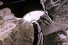
Glen Canyon Dam is a concrete arch-gravity dam in the southwestern United States, located on the Colorado River in northern Arizona, near the city of Page. The 710-foot-high (220 m) dam was built by the Bureau of Reclamation (USBR) from 1956 to 1966 and forms Lake Powell, one of the largest man-made reservoirs in the U.S. with a capacity of more than 25 million acre-feet (31 km3). The dam is named for Glen Canyon, a series of deep sandstone gorges now flooded by the reservoir; Lake Powell is named for John Wesley Powell, who in 1869 led the first expedition to traverse the Colorado River's Grand Canyon by boat.

<span class="mw-page-title-main">Lake Powell</span> Reservoir in Utah and Arizona, United States

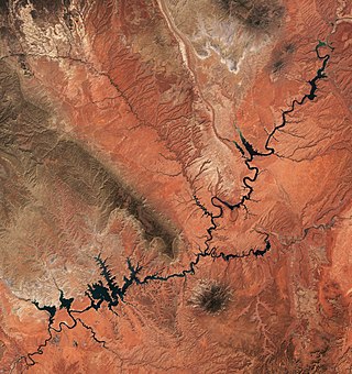
Lake Powell is an artificial reservoir on the Colorado River in Utah and Arizona, United States. It is a major vacation destination visited by approximately two million people every year. It is the second largest artificial reservoir by maximum water capacity in the United States behind Lake Mead, storing 24,322,000 acre-feet (3.0001×10¹⁰ m3) of water when full. However, Lake Mead has fallen below Lake Powell in size several times during the 21st century in terms of volume of water, depth and surface area.

<span class="mw-page-title-main">San Juan River (Colorado River tributary)</span> River in Utah, United States

The San Juan River is a major tributary of the Colorado River in the Southwestern United States, providing the chief drainage for the Four Corners region of Colorado, New Mexico, Utah, and Arizona. Originating as snowmelt in the San Juan Mountains of Colorado, it flows 383 miles (616 km) through the deserts of northern New Mexico and southeastern Utah to join the Colorado River at Glen Canyon.

<span class="mw-page-title-main">Gunnison River</span> Tributary of the Colorado River in Colorado, United States

The Gunnison River is located in western Colorado, United States and is one of the largest tributaries of the Colorado River.

<span class="mw-page-title-main">Curecanti National Recreation Area</span> National Park Service in Colorado, US

Curecanti National Recreation Area is a National Park Service unit located on the Gunnison River in western Colorado. Established in 1965, Curecanti National Recreation Area is responsible for developing and managing recreational facilities on three reservoirs, Blue Mesa Reservoir, Morrow Point Reservoir and Crystal Reservoir, constructed on the upper Gunnison River in the 1960s by the U.S. Bureau of Reclamation to better utilize the vital waters of the Colorado River and its major tributaries. A popular destination for boating and fishing, Curecanti offers visitors two marinas, traditional and group campgrounds, hiking trails, boat launches, and boat-in campsites. The state's premiere lake trout and Kokanee salmon fisheries, Curecanti is a popular destination for boating and fishing, and is also a popular area for ice-fishing in the winter months.

<span class="mw-page-title-main">Flaming Gorge Dam</span> Dam on the Green River in Utah, United States

Flaming Gorge Dam is a concrete thin-arch dam on the Green River, a major tributary of the Colorado River, in northern Utah in the United States. Flaming Gorge Dam forms the Flaming Gorge Reservoir, which extends 91 miles (146 km) into southern Wyoming, submerging four distinct gorges of the Green River. The dam is a major component of the Colorado River Storage Project, which stores and distributes upper Colorado River Basin water.

<span class="mw-page-title-main">Blue Mesa Reservoir</span> Lake on the Gunnison River in Colorado, United States

Blue Mesa Reservoir is an artificial reservoir located on the upper reaches of the Gunnison River in Gunnison County, Colorado. The largest lake located entirely within the state, Blue Mesa Reservoir was created by the construction of Blue Mesa Dam, a 390 feet (120 m) tall earthen fill dam constructed on the Gunnison by the U.S. Bureau of Reclamation in 1966 for the generation of hydroelectric power. Managed as part of the Curecanti National Recreation Area, a unit of the National Park Service, Blue Mesa Reservoir is the largest lake trout and Kokanee salmon fishery in Colorado.

<span class="mw-page-title-main">Blue Mesa Dam</span> Dam in Colorado, United States

Blue Mesa Dam is a 390-foot-tall (120 m) zoned earthfill dam on the Gunnison River in Colorado. It creates Blue Mesa Reservoir, and is within Curecanti National Recreation Area just before the river enters the Black Canyon of the Gunnison. The dam is upstream of the Morrow Point Dam. Blue Mesa Dam and reservoir are part of the Bureau of Reclamation's Wayne N. Aspinall Unit of the Colorado River Storage Project, which retains the waters of the Colorado River and its tributaries for agricultural and municipal use in the American Southwest. Although the dam does produce hydroelectric power, its primary purpose is water storage. State Highway 92 passes over the top of the dam. Blue Mesa Dam houses two turbine generators and produces an average of 264,329,000 kilowatt-hours each year.

<span class="mw-page-title-main">Morrow Point Dam</span> Dam on the Gunnison River in Colorado

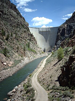
Morrow Point Dam is a 468-foot-tall (143 m) concrete double-arch dam on the Gunnison River located in Colorado, the first dam of its type built by the U.S. Bureau of Reclamation. Located in the upper Black Canyon of the Gunnison, it creates Morrow Point Reservoir, and is within the National Park Service-operated Curecanti National Recreation Area. The dam is between the Blue Mesa Dam (upstream) and the Crystal Dam (downstream). Morrow Point Dam and reservoir are part of the Bureau of Reclamation's Wayne N. Aspinall Unit of the Colorado River Storage Project, which retains the waters of the Colorado River and its tributaries for agricultural and municipal use in the American Southwest. The dam's primary purpose is hydroelectric power generation.

<span class="mw-page-title-main">Crystal Dam</span> Dam on the Gunnison River in Colorado, United States

Crystal Dam is a 323-foot-tall (98 m), double-curvature, concrete, thin arch dam located 6 miles downstream from Morrow Point Dam on the Gunnison River in Colorado, United States. Crystal Dam is the newest of the three dams in Curecanti National Recreation Area; construction on the dam was finished in 1976. The dam impounds Crystal Reservoir. Crystal Dam and Reservoir are part of the Bureau of Reclamation's Wayne N. Aspinall Unit of the Colorado River Storage Project, which retains the waters of the Gunnison River and its tributaries for agricultural and municipal use in the American Southwest. The dam's primary purpose is hydroelectric power generation.

<span class="mw-page-title-main">Navajo Dam</span> Dam in San Juan and Rio Arriba Counties, New Mexico

Navajo Dam is a dam on the San Juan River, a tributary of the Colorado River, in northwestern New Mexico in the United States. The 402-foot (123 m) high earthen dam is situated in the foothills of the San Juan Mountains about 44 miles (71 km) upstream and east of Farmington, New Mexico. It was built by the U.S. Bureau of Reclamation (Reclamation) in the 1960s to provide flood control, irrigation, domestic and industrial water supply, and storage for droughts. A small hydroelectric power plant was added in the 1980s.

<span class="mw-page-title-main">Curecanti Needle</span> Granite spire in Colorado, USA

The Curecanti Needle is a 700-ft granite spire located on the Gunnison River in western Colorado. A notable landmark to generations of natives and pioneers, the Needle is located on the southern bank of Morrow Point Reservoir, an impoundment of the Gunnison river between Gunnison and Montrose, Colorado. Used for many years as an advertising symbol for the Denver and Rio Grande Western Railroad, whose narrow-gauge railway famously ran along the northern bank of the river and passed near the Needle, the spire is today part of the Curecanti National Recreation Area, a National Park Service facility that encompasses three impoundments of the Gunnison river, including Morrow Point Reservoir.

<span class="mw-page-title-main">Risks to the Glen Canyon Dam</span> Aspect of dam construction

Glen Canyon Dam, a concrete arch dam on the Colorado River in the American state of Arizona, is viewed as carrying a large amount of risk, most notably due to siltation. The Colorado and San Juan rivers deposit large volumes of silt into Lake Powell, slowly decreasing its capacity. The sediment will eventually build up against the dam and could affect its safe operation and lead to its failure.

<span class="mw-page-title-main">Bridge Canyon Dam</span> Proposed dam in Mohave County, Arizona

Bridge Canyon Dam, also called Hualapai Dam, was a proposed dam in the lower Grand Canyon of the Colorado River, in northern Arizona in the United States. It would have been located near Bridge Canyon Rapids in an extremely rugged and isolated portion of the canyon, 235 miles (378 km) downstream of Lees Ferry and at the uppermost end of Lake Mead.

<span class="mw-page-title-main">Morrow Point Reservoir</span> Reservoir on the Gunnison River in Colorado

Morrow Point Reservoir is an 817-acre (331 ha) artificial reservoir on the Gunnison River in western Colorado. Located in the upper Black Canyon of the Gunnison, the lake was created in 1968 by the U.S. Bureau of Reclamation as part of a larger plan to impound the upper section of the Gunnison and create opportunities for hydroelectric power generation, water conservation, and recreation. Morrow Point Reservoir is managed by the National Park Service as a unit within the Curecanti National Recreation Area, and is the location of the Curecanti Needle, a striking 700-foot (210 m) granite spire on the reservoir's southern bank whose unique shape was for decades a recognized symbol of the Denver and Rio Grande Western Railroad.

Crystal Reservoir is a 340-acre artificial reservoir on the Gunnison River in western Colorado. Located in the upper Black Canyon of the Gunnison, the lake was created in 1976 by the U.S. Bureau of Reclamation as part of a larger plan to impound the upper section of the Gunnison for the generation of hydroelectric power, water storage, and public recreation. Crystal Reservoir is managed by the National Park Service as an element of the Curecanti National Recreation Area. Located at the far western end of Curecanti, Crystal Reservoir is the smallest, least developed, and least accessible of the three reservoirs within the park.

<span class="mw-page-title-main">Echo Park Dam</span> Unbuilt dam in northwestern Colorado, United States

Echo Park Dam was proposed in the 1950s by the U.S. Bureau of Reclamation as a central feature of the Colorado River Storage Project. Situated on the Green River, a major tributary of the Colorado River, the dam was proposed for the Echo Park district of Dinosaur National Monument, flooding much of the Green and Yampa river valleys in the monument. The dam was bitterly opposed by preservationists, who saw the encroachment of a dam into an existing national park as another Hetch Hetchy, to be opposed as an appropriation of protected lands for development purposes. The Echo Park project was abandoned in favor of Glen Canyon Dam on the main stem of the Colorado, in lands that were not at that time protected. This was eventually regarded as a strategic mistake by conservation organizations.

References

  1. 1 2 3 4 5 6 7 "Colorado River Storage Project". Bureau of Reclamation. Archived from the original on 2008-03-17. Retrieved 2008-05-22.
  2. "The Bureau of Reclamation: A Very Brief History". US Bureau of Reclamation. Archived from the original on 2008-05-14. Retrieved 2008-05-22.
  3. Gelt, Joe (1997). "Sharing Colorado River Water: History, Public Policy and the Colorado River Compact". University of Arizona. Archived from the original on 2008-05-12. Retrieved 2008-05-22.
  4. 1 2 Adler, Robert W. (2007). Restoring Colorado River Ecosystems: A Troubled Sense of Immensity . Chicago: Island Press. p.  15. ISBN   978-1597260572.
  5. "Colorado River Storage Project – Authority to Construct, Operate and Maintain" (PDF). US Congress. 1956-04-11. Archived from the original (PDF) on 2008-10-06. Retrieved 2008-05-22.
  6. "Glen Canyon Powerplant". Bureau of Reclamation. 2005-12-28. Archived from the original on 2008-03-11. Retrieved 2008-05-22.
  7. McKinnon, Shaun (2007-05-28). "At age 50, dam still generates love, hate" (PDF). The Arizona Republic . Retrieved 2008-05-22.
  8. "Flaming Gorge Dam". Bureau of Reclamation. Archived from the original on 2008-03-13. Retrieved 2008-05-22.
  9. "Navajo Dam". Bureau of Reclamation. Archived from the original on 2008-03-13. Retrieved 2008-05-22.
  10. "Aspinall, Wayne N., Unit". Recreation.gov. Archived from the original on 2008-09-16. Retrieved 2008-05-22.
  11. Schulte, Steven C. (2002). Wayne Aspinall and the Shaping of the American West . Norman, Oklahoma: University of Oklahoma Press. ISBN   978-0870816659.
  12. "Blue Mesa Powerplant". Bureau of Reclamation. 2005-12-28. Archived from the original on 2008-03-29. Retrieved 2008-05-22.
  13. "Morrow Point Power Plant". Bureau of Reclamation. 2005-12-29. Archived from the original on 2008-03-03. Retrieved 2008-05-22.
  14. "Crystal Powerplant". Bureau of Reclamation. 2005-12-28. Archived from the original on 2008-03-03. Retrieved 2008-05-22.
  15. "HIT LIST: PRESIDENT CARTER'S REVIEW OF RECLAMATION WATER PROJECTS AND HIS IMPACT ON FEDERAL WATER POLICY" . Retrieved 30 March 2023.
  16. "50 years later, Glen Canyon Dam still controversial". USA Today. Retrieved 2018-06-17.
  17. "Dams destabilize river food webs: Lessons from the Grand Canyon". Cary Institute of Ecosystem Studies. Retrieved 2018-06-17.
  18. "Grand Canyon sandbars have rapidly eroded". msnbc.com. 2008-09-10. Retrieved 2018-06-17.
  19. "Record Drought Reveals Stunning Changes Along Colorado River". 2014-11-23. Archived from the original on November 24, 2014. Retrieved 2018-06-17.
  20. Davis, Tony. "Study: Humans to blame for big water losses in region". Arizona Daily Star. Retrieved 2018-06-17.
  21. Zielinski, Sarah. "The Colorado River Runs Dry". Smithsonian. Retrieved 2018-06-17.