Columbus, Minnesota

Last updated

Columbus
Motto: 
"Rural Nature. Urban Access." [1]
Anoka Cnty Minnesota Incorporated and Unincorporated areas Columbus Highlighted.png
Location of the city of Columbus
within Anoka County, Minnesota
Coordinates: 45°16′06″N93°04′51″W / 45.26833°N 93.08083°W / 45.26833; -93.08083
Country United States
State Minnesota
County Anoka
IncorporatedSeptember 21, 2006
Area
[2]
  Total47.69 sq mi (123.51 km2)
  Land44.85 sq mi (116.16 km2)
  Water2.84 sq mi (7.35 km2)
Elevation
[3]
906 ft (276 m)
Population
 (2020)
  Total4,159
  Density92.73/sq mi (35.80/km2)
Time zone UTC-6 (Central (CST))
  Summer (DST) UTC-5 (CDT)
ZIP code
55025
Area code 651
FIPS code 27-12718 [4]
GNIS feature ID2393610 [3]
Website www.ci.columbus.mn.us

Columbus is a city in Anoka County, Minnesota, United States. The population was 3,914 at the 2010 census. [5]

Contents

History

The city was known as Columbus Township until September 21, 2006, when it was incorporated as the city of Columbus, in response to concerns that the adjacent city of Forest Lake was planning to annex portions of the township. [6]

Mel Mettler, the first mayor of Columbus, was reelected in 2008. Jesse Preiner was elected mayor in 2019.

Running Aces Harness Park, a 5/8 mile harness horse racing track, opened in Columbus in April 2008.

Geography

According to the United States Census Bureau, the city has an area of 47.76 square miles (123.70 km2), of which 44.92 square miles (116.34 km2) is land and 2.84 square miles (7.36 km2) is water. [7]

Anoka County Roads 18, 19, 23, 54, and 62 are the main routes in the community. Interstate 35 splits into Interstates 35E and 35W within the southeast corner of Columbus. The junction is commonly known as the Forest Lake Split, after the city to the immediate east.

Rice Creek flows through Columbus. [8] Carlos Avery Wildlife Area is in the north-central and west-central parts of the city.

Nearby places include Forest Lake, Lino Lakes, Ham Lake, East Bethel, and Wyoming.

Demographics

Historical population
CensusPop.Note
1860 119
1870 71−40.3%
1880 9229.6%
1890 262184.8%
1900 48484.7%
1910 58520.9%
1920 569−2.7%
1930 5974.9%
1940 65810.2%
1950 74813.7%
1960 90821.4%
1970 1,999120.2%
1980 3,23261.7%
1990 3,69014.2%
2000 3,9577.2%
2010 3,914−1.1%
2020 4,1596.3%
U.S. Decennial Census [9]

2010 census

As of the census [10] of 2010, there were 3,914 people, 1,416 households, and 1,119 families residing in the city. The population density was 87.1 inhabitants per square mile (33.6/km2). There were 1,464 housing units at an average density of 32.6 per square mile (12.6/km2). The racial makeup of the city was 93.6% White, 0.7% African American, 0.6% Native American, 3.6% Asian, 0.1% Pacific Islander, 0.2% from other races, and 1.2% from two or more races. Hispanic or Latino of any race were 1.6% of the population.

There were 1,416 households, of which 31.3% had children under the age of 18 living with them, 69.1% were married couples living together, 5.2% had a female householder with no husband present, 4.8% had a male householder with no wife present, and 21.0% were non-families. 15.5% of all households were made up of individuals, and 5.9% had someone living alone who was 65 years of age or older. The average household size was 2.76 and the average family size was 3.08.

The median age in the city was 45.3 years. 22.3% of residents were under the age of 18; 7.5% were between the ages of 18 and 24; 19.5% were from 25 to 44; 39.6% were from 45 to 64; and 11.2% were 65 years of age or older. The gender makeup of the city was 51.9% male and 48.1% female.

2000 census

As of the census [4] of 2000, there were 3,957 people, 1,328 households, and 1,120 families residing in the township. The population density was 88.2 inhabitants per square mile (34.1/km2). There were 1,358 housing units at an average density of 30.3 per square mile (11.7/km2). The racial makeup of the township was 97.60% White, 0.18% African American, 0.56% Native American, 0.56% Asian, 0.08% from other races, and 1.04% from two or more races. Hispanic or Latino of any race were 0.58% of the population.

There were 1,328 households, out of which 39.3% had children under the age of 18 living with them, 74.9% were married couples living together, 5.3% had a female householder with no husband present, and 15.6% were non-families. 11.1% of all households were made up of individuals, and 2.8% had someone living alone who was 65 years of age or older. The average household size was 2.97 and the average family size was 3.22.

In the township the population was spread out, with 27.8% under the age of 18, 7.5% from 18 to 24, 29.5% from 25 to 44, 28.9% from 45 to 64, and 6.2% who were 65 years of age or older. The median age 38. For every 100 females, there were 106.5 males. For every 100 females age 18 and over, there were 106.2 males.

The median income for a household in the township was $67,500, and the median income for a family was $71,809. Males had a median income of $42,948 versus $31,417 for females. The per capita income for the township was $24,479. About 2.2% of families and 3.8% of the population were below the poverty line, including 3.2% of those under age 18 and 2.8% of those age 65 or over.

Related Research Articles

Hill Lake Township is a township in Aitkin County, Minnesota, United States. The population was 430 as of the 2010 census.

<span class="mw-page-title-main">East Bethel, Minnesota</span> City in Minnesota, United States

East Bethel is a city in Anoka County, Minnesota, United States. The population was 11,786 at the 2020 census.

<span class="mw-page-title-main">Ham Lake, Minnesota</span> City in Minnesota, United States

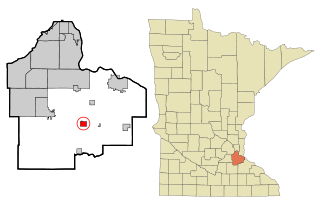
Ham Lake is a city in Anoka County, Minnesota, United States. It is a suburb in the Minneapolis–Saint Paul metropolitan area. The population was 15,296 at the 2010 census. It is in the Anoka-Hennepin School District, one of Minnesota's largest school districts.

<span class="mw-page-title-main">Wyoming, Minnesota</span> City in Minnesota, United States

Wyoming is a city in Chisago County, Minnesota. The population was 7,791 at the time of the 2010 census.

Jenkins Township is a township in Crow Wing County, Minnesota, United States. The population was 425 at the 2000 census.

<span class="mw-page-title-main">Hampton, Minnesota</span> City in Minnesota, United States

Hampton is a city in Dakota County, Minnesota, United States. The population was 689 at the 2010 census.

<span class="mw-page-title-main">Brandon, Minnesota</span> City in Minnesota, United States

Brandon is a city in Douglas County, Minnesota, United States. The population was 501 at the 2020 census.

Verona Township is a township in Faribault County, Minnesota, United States. The population was 391 at the 2000 census.

Oteneagen Township is a township in Itasca County, Minnesota, United States. The population was 310 at the 2010 census.

Chengwatana Township is a township in Pine County, Minnesota, United States. The population was 809 at the 2000 census. Chengwatana Township was organized in 1874. Its name is derived from the Ojibwe Zhingwaadena, applied originally to an Ojibwe village located at the confluence of the Snake River with the St. Croix River. Neighbouring Pine City Township and the City of Pine City get their names from the English translation of Chengwatana.

Pine City Township is a township in Pine County, Minnesota, United States, located south and east of the city of Pine City. The township population was 1,249 at the 2000 census.

<span class="mw-page-title-main">McIntosh, Minnesota</span> City in Minnesota, United States

McIntosh is a city in Polk County, Minnesota, United States. It is part of the Grand Forks, ND-MN Metropolitan Statistical Area. The population was 606 at the 2020 census.

Cannon City Township is a township in Rice County, Minnesota, United States. The population was 1,212 at the 2000 census.

Van Buren Township is a township in Saint Louis County, Minnesota, United States. It was named for Martin Van Buren, the eighth President of the United States. The population was 189 at the 2010 census.

<span class="mw-page-title-main">Belgrade, Minnesota</span> City in Minnesota, United States

Belgrade is a city in Stearns County, Minnesota, United States. The population was 740 at the 2010 census. It is part of the St. Cloud Metropolitan Statistical Area. Belgrade is home to the world's largest black Crow.

Brockway Township is a township in Stearns County, Minnesota, United States. The population was 2,702 at the 2010 census. The township includes the City of St. Stephen.

Holding Township is a township in Stearns County, Minnesota, United States. It includes the city of Holdingford. The township population was 1,139 at the 2010 census.

Millwood Township is a township in Stearns County, Minnesota, United States. The population was 972 at the 2010 census. The township includes the city of St. Rosa.

Sauk Centre Township is a township in Stearns County, Minnesota, United States. The population was 1,088 at the 2010 census.

St. Joseph Township is a township in Stearns County, Minnesota, United States. The population was 1,924 at the 2010 census. The township borders the western side of the cities of St. Cloud and Waite Park, and completely surrounds the city of St. Joseph. All are components of the St. Cloud Metropolitan Statistical Area.

References

  1. "City of Columbus Minnesota". City of Columbus Minnesota. Retrieved October 14, 2012.
  2. "2020 U.S. Gazetteer Files". United States Census Bureau. Retrieved July 24, 2022.
  3. 1 2 U.S. Geological Survey Geographic Names Information System: Columbus, Minnesota
  4. 1 2 "U.S. Census website". United States Census Bureau . Retrieved January 31, 2008.
  5. "2010 Census Redistricting Data (Public Law 94-171) Summary File". American FactFinder. U.S. Census Bureau, 2010 Census. Retrieved April 23, 2011.[ dead link ]
  6. Levy, Paul (July 12, 2006). "Columbus Township, site of proposed harness track, will become city". Minneapolis Star Tribune. Retrieved July 12, 2006.[ dead link ]
  7. "US Gazetteer files 2010". United States Census Bureau. Archived from the original on January 25, 2012. Retrieved November 13, 2012.
  8. King's Twin Cities Metro Street Atlas '04. Minneapolis: The Lawrence Group. 2004. ISBN   1-58301-215-X.
  9. "Census of Population and Housing". Census.gov. Retrieved June 4, 2015.
  10. "U.S. Census website". United States Census Bureau . Retrieved November 13, 2012.