Martin Lake, Minnesota

Last updated
Martin Lake
USA Minnesota location map.svg
Red pog.svg
Martin Lake
Location of the community of Martin Lake
within Linwood Township, Anoka County
Usa edcp location map.svg
Red pog.svg
Martin Lake
Martin Lake (the United States)
Coordinates: 45°22′52″N93°05′42″W / 45.38111°N 93.09500°W / 45.38111; -93.09500 Coordinates: 45°22′52″N93°05′42″W / 45.38111°N 93.09500°W / 45.38111; -93.09500
Country United States
State Minnesota
County Anoka County
Township Linwood Township
Area
[1]
  Total1.75 sq mi (4.53 km2)
  Land1.38 sq mi (3.57 km2)
  Water0.37 sq mi (0.97 km2)
Elevation
919 ft (280 m)
Population
 (2020)
  Total907
  Density658.68/sq mi (254.25/km2)
Time zone UTC-6 (Central (CST))
  Summer (DST) UTC-5 (CDT)
ZIP code
55079
Area code(s) 651 and 763
GNIS feature ID647575 [2]

Martin Lake is an unincorporated community and census-designated place (CDP) in Linwood Township, Anoka County, Minnesota, United States. Its population was 933 as of the 2010 census. [3]

Contents

Anoka County Road 26 and Anoka County Road 85 serve as two main routes in the community. Anoka County Road 22 is nearby.

Martin Lake is located within ZIP code 55079, based in Stacy. Nearby places include East Bethel and Stacy.

Demographics

Historical population
CensusPop.
2010 933
2020 907−2.8%
U.S. Decennial Census [4]

2010 census

As of the census [3] of 2010, there were 933 people, 375 households, and 267 families in the CDP. The population density was 677.6 inhabitants per square mile (261.6/km2). There were 434 housing units at an average density of 315.2 per square mile (121.7/km2). The racial makeup of the CDP was 97.1% White, 0.8% African American, 0.3% Native American, 0.4% Asian, 0.3% from other races, and 1.1% from two or more races. Hispanic or Latino of any race were 1.8% of the population.

There were 375 households, of which 27.7% had children under the age of 18 living with them, 56.8% were married couples living together, 7.7% had a female householder with no husband present, 6.7% had a male householder with no wife present, and 28.8% were non-families. 22.9% of all households were made up of individuals, and 2.9% had someone living alone who was 65 years of age or older. The average household size was 2.49 and the average family size was 2.91.

The median age in the CDP was 44.5 years. 20.8% of residents were under the age of 18; 7.1% were between the ages of 18 and 24; 23.6% were from 25 to 44; 42.0% were from 45 to 64; and 6.5% were 65 years of age or older. The gender makeup of the CDP was 54.3% male and 45.7% female.

Related Research Articles

Twin Lakes, California Census-designated place in California, United States

Twin Lakes is a census-designated place (CDP) in Santa Cruz County, California, United States. The population is at an estimated 5,378 as of 2016 which is up by 461 in 2010.

Crystal Lake, Connecticut Census-designated place in Connecticut, United States

Crystal Lake is a village census-designated place and part of the town of Ellington, in Tolland County, Connecticut, United States. The population was 1,945 at the 2010 census. The CDP includes an eponymous lake.

Pittman, Florida Census-designated place in Florida

Pittman is an unincorporated community and census-designated place (CDP) in Lake County, Florida, United States. The population was 180 at the 2010 census. It is part of the Orlando–Kissimmee Metropolitan Statistical Area.

Stacy Street is a street and surrounding census-designated place (CDP) in Palm Beach County, Florida, United States. The population was 958 at the 2000 census, which misspelled it Stacey Street.

Lake Shore, Maryland Census-designated place in Maryland, United States

Lake Shore is a census-designated place and unincorporated community in Anne Arundel County, Maryland, United States, located east of Pasadena. The population of Lake Shore was 19,477 at the 2010 census.

China Lake Acres, California Census-designated place in California, United States

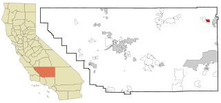
China Lake Acres is a census-designated place (CDP) in Kern County, California, United States. The population was 1,876 at the 2010 census, up from 1,761 at the 2000 census.

Andover, Minnesota City in Minnesota, United States

Andover is a city in Anoka County, Minnesota, United States. The population was 32,601 at the 2020 census.

East Bethel, Minnesota City in Minnesota, United States

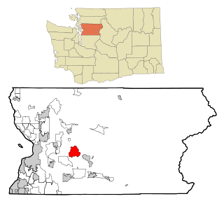
East Bethel is a city in Anoka County, Minnesota, United States. The population was 11,786 at the 2020 census.

Lexington, Minnesota City in Minnesota, United States

Lexington is a city in Anoka County, Minnesota, United States, and is a northern suburb of the Twin Cities metropolitan area. The population was 2,049 at the 2010 census.

Linwood Township, Anoka County, Minnesota Township in Minnesota, United States

Linwood Township is a township in Anoka County, Minnesota, United States. The population was 5,123 at the 2010 census. The township contains the census-designated place of Martin Lake and the unincorporated village of Linwood. Linwood Township is the only area of Anoka County that is not an incorporated city.

Budd Lake, New Jersey Census-designated place in New Jersey, United States

Budd Lake is an unincorporated community and census-designated place (CDP) located within Mount Olive Township, in Morris County, New Jersey, United States. As of the 2010 United States Census, the CDP's population was 8,968. Budd Lake was named for John Budd. Prior to that, it was called Hattacawanna Lake.

Cedar Glen West, New Jersey Census-designated place in New Jersey, United States

Cedar Glen West is an unincorporated community and census-designated place (CDP) located within Manchester Township, in Ocean County, New Jersey, United States. As of the 2010 United States Census, the CDP's population was 1,267.

Lake Wynonah is a census-designated place (CDP) in Schuylkill County, Pennsylvania, United States. The population was 1,961 at the 2000 census, and 2,640 at the 2010 census. Lake Wynonah is a gated community with two lakes, Fawn Lake and Lake Wynonah, and as of July 2008, there are over 1200 homes and 1500 members. It is in South Manheim and Wayne Townships.

Lake Roesiger, Washington CDP in Washington, United States

Lake Roesiger is a census-designated place (CDP) in Snohomish County, Washington, United States. The population was 503 at the 2010 census.

Lochsloy, Washington CDP in Washington, United States

Lochsloy is a census-designated place (CDP) in Snohomish County, Washington, United States. The population was 2,533 at the 2010 census.

Lake Lac La Belle, Wisconsin Former Census-designated place in Wisconsin, United States

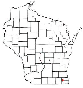
Lake Lac La Belle is a former census-designated place (CDP) in Jefferson County, Wisconsin, United States. The population was 833 at the 2000 census.

Browns Lake, Wisconsin CDP in Wisconsin, United States

Browns Lake is a census-designated place (CDP) in Racine County, Wisconsin around a lake of the same name. The population was 2,039 at the 2010 census. It is politically a part of the town of Burlington, along with Bohners Lake.

Wind Lake, Wisconsin CDP in Wisconsin, United States

Wind Lake is a census-designated place (CDP) in Racine County, Wisconsin, United States. The population was 5,342 at the 2010 census. Wind Lake is in the town of Norway.

Spring Lake Park, Minnesota City in Minnesota, United States

Spring Lake Park is a city in Anoka and Ramsey counties in the state of Minnesota. The population was 6,412 at the 2010 census. The city is located mainly within Anoka County. Minnesota State Highways 47 and 65 and County Highway 10 are three of the main routes in the city.

Highland Lakes, New Jersey Census-designated place in New Jersey, United States

Highland Lakes is an unincorporated community and census-designated place (CDP) located within Vernon Township, in Sussex County, New Jersey, United States. As of the 2010 United States Census, the CDP's population was 4,933. Highland Lakes has its own Post Office with the ZIP code 07422.

References

  1. "2020 U.S. Gazetteer Files". United States Census Bureau. Retrieved July 24, 2022.
  2. "Martin Lake, Minnesota". Geographic Names Information System . United States Geological Survey.
  3. 1 2 "U.S. Census website". United States Census Bureau . Retrieved 2011-05-14.
  4. "Census of Population and Housing". Census.gov. Retrieved May 11, 2019.