Interstate 95 (I-95) is the main north–south Interstate Highway on the East Coast of the United States, running from U.S. Route 1 (US 1) in Miami, Florida, north to the Houlton–Woodstock Border Crossing between Maine and the Canadian province of New Brunswick. The highway largely parallels the Atlantic coast and US 1, except for the portion between Savannah, Georgia, and Washington, D.C., and the portion between Portland and Houlton in Maine, both of which follow a more direct inland route.

The New Jersey Turnpike (NJTP) is a system of controlled-access toll roads in the U.S. state of New Jersey. The turnpike is maintained by the New Jersey Turnpike Authority (NJTA). The 117.20-mile (188.62 km) mainline's southern terminus is at Interstate 295 (I-295) and U.S. Route 40 (US 40) in Pennsville Township in Salem County, near the Delaware Memorial Bridge. Its northern terminus is at an interchange with I-80 and US 46 in Ridgefield Park. Construction of the mainline from concept to completion took 22 months, from 1950 to 1951. It was opened to traffic on November 5, 1951, between its southern terminus and exit 10.

Route 44 is a state highway located in Gloucester County in the U.S. state of New Jersey. It runs 10.28 mi (16.54 km) from Barker Avenue in Bridgeport to a cul-de-sac at a ramp from southbound Interstate 295 (I-295) and U.S. Route 130 in Thorofare. The route, which is mostly a two-lane undivided road, passes through the communities of Gibbstown and Paulsboro in the northern part of the county, a short distance south of the Delaware River. Route 44 generally runs a short distance to the north of I-295/US 130 for much of its length.
U.S. Route 46 (US 46) is an east–west U.S. Highway completely within the state of New Jersey, running for 75.34 mi (121.25 km), making it the shortest signed, non-spur U.S. Highway. The west end is at an interchange with Interstate 80 (I-80) and Route 94 in Columbia, Warren County, on the Delaware River. The east end is in the middle of the George Washington Bridge over the Hudson River in Fort Lee, Bergen County, while the route is concurrent with I-95 and US 1-9. Throughout much of its length, US 46 is closely paralleled by I-80. US 46 is a major local and suburban route, with some sections built to or near freeway standards and many other sections arterials with jughandles. The route runs through several communities in the northern part of New Jersey, including Hackettstown, Netcong, Dover, Parsippany-Troy Hills, Wayne, Clifton, Ridgefield Park, Palisades Park, and Fort Lee. It crosses over the Upper Passaic River at several points. The road has been ceremonially named the United Spanish–American War Veterans Memorial Highway.

Route 324 is an isolated and partially closed state highway in Logan Township in the U.S. state of New Jersey. The two-lane concrete route runs along the 1.51-mile-long (2.43 km) alignment of Old Ferry Road from the shore of the Delaware River to a cul-de-sac near the interchange between U.S. Route 322 (US 322) and US 130 in Logan Township. The route does not intersect with any state routes or county routes along its entire alignment. The portion from the Delaware River to Springers Lane, consisting of over half of the route, is marked with a "Road Closed" sign, with minimal if any maintenance — potholes and overgrowing vegetation plague this section.
E-ZPass is an electronic toll collection system used on toll roads, toll bridges, and toll tunnels in the Eastern United States, Midwestern United States, and Southern United States. The E-ZPass Interagency Group (IAG) consists of member agencies in several states, which use the same technology and allow travelers to use the same transponder on toll roads throughout the network.

The Delaware River Port Authority (DRPA), officially the Delaware River Port Authority of Pennsylvania and New Jersey, is a bi-state agency instrumentality created by a congressionally approved interstate compact between the state governments of Pennsylvania and New Jersey. The authority is principally charged to maintain and develop transportation links between the two states with four bridges and a mass transit rail line across the Delaware River. Though the DRPA has "port" in its name, it does not own or operate any ports.

The Delaware Memorial Bridge is a dual-span suspension bridge crossing the Delaware River. The toll bridges carry Interstate 295 and U.S. Route 40 and is also the link between Delaware and New Jersey. The bridge was designed by the firm of Howard, Needles, Tammen & Bergendoff with consulting help from engineer Othmar Ammann, whose other designs include the George Washington Bridge and the Verrazzano-Narrows Bridge.

The Betsy Ross Bridge is a continuous steel truss bridge spanning the Delaware River from Philadelphia, Pennsylvania to Pennsauken, New Jersey. It was built from 1969 to 1974, and opened in April 1976, during the American Bicentennial Year. It was originally planned to be named as the "Delair Bridge", after a paralleling vertical lift bridge owned by Pennsylvania Railroad, which is now used by Conrail Shared Assets Operations and New Jersey Transit's Atlantic City Line, but was instead later named for Betsy Ross, a Philadelphia seamstress and creator of the first American flag in 1776. It was the first automotive bridge named for a woman in the United States, and the second U.S. bridge overall named for a woman after Iowa's Boone High Bridge was renamed the Kate Shelley High Bridge in 1912.

U.S. Route 322 is a 494-mile-long (795.0 km), east–west United States Highway, traversing Ohio, Pennsylvania, and New Jersey. The road is a spur of US 22 and one of the original highways from 1926. A portion of it at one time was concurrent with the Lakes-to-Sea Highway.

Interstate 295 (I-295) in Delaware, New Jersey, and Pennsylvania is an auxiliary Interstate Highway, designated as a bypass around Philadelphia, Pennsylvania, and a partial beltway of Trenton, New Jersey.
The Delaware River Joint Toll Bridge Commission (DRJTBC) is a bistate, public agency that maintains and operates river crossings connecting the U.S. states of Pennsylvania and New Jersey. The agency's jurisdiction stretches roughly 140 miles (230 km) along the Delaware River from Philadelphia and Bucks County in southeast Pennsylvania and then north through the Lehigh Valley and to Pennsylvania-New York state border.
Interstate 80 (I-80) is a major Interstate Highway in the United States, running from San Francisco, California, eastward to the New York metropolitan area. In New Jersey, I-80 runs for 68.35 miles (110.00 km) from the Delaware Water Gap Toll Bridge at the Pennsylvania state line to its eastern terminus at I-95 in Teaneck, Bergen County. I-95 continues from the end of I-80 to the George Washington Bridge for access to New York City. The highway runs parallel to U.S. Route 46 (US 46) through rural areas of Warren and Sussex counties before heading into more suburban surroundings in Morris County. As the road continues into Passaic and Bergen counties, it heads into more urban areas. The New Jersey Department of Transportation (NJDOT) identifies I-80 within the state as the Christopher Columbus Highway.

The Delaware Water Gap Toll Bridge is a toll bridge that carries Interstate 80 across the Delaware River at the Delaware Water Gap, connecting Hardwick Township, Warren County, New Jersey, and Delaware Water Gap, Monroe County, Pennsylvania, in the United States. The bridge was built by the Delaware River Joint Toll Bridge Commission. The 2,465-foot-long (751 m) bridge is a multiple span dual roadway with a steel plate structure. The roadways are 28 feet (8.5 m) wide each and separated from each other by a concrete Jersey barrier.

The Pennsylvania Turnpike/Interstate 95 Interchange Project is a road construction project that built an interchange between Interstate 95 (I-95) and the Pennsylvania Turnpike in Bristol Township, Bucks County, Pennsylvania, in the United States. The $553 million first stage is complete: a pair of flyover ramps–one connecting I-95 northbound with the eastbound turnpike and the other connecting the westbound turnpike with I-95 southbound—that opened in 2018, with some cleanups to connecting roads completed in 2021. Construction of the remaining ramps is expected to begin when funding is available.

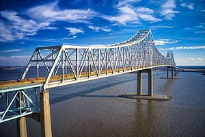
The Delaware River–Turnpike Toll Bridge is a four-lane, steel through arch bridge crossing the Delaware River between Burlington Township, Burlington County, New Jersey and Bristol Township, Bucks County, Pennsylvania. As a part of Interstate 95 (I-95), it is a major highway link between Philadelphia and New York City. The bridge also connects the Pennsylvania Turnpike's east-west mainline with the main trunk of the New Jersey Turnpike, via the Pearl Harbor Memorial Turnpike Extension. Tolls are collected only in the west/southbound direction via electronic toll collection.
U.S. Route 322 is a spur of U.S. Route 22, running from Cleveland, Ohio, east to Atlantic City, New Jersey. The easternmost segment of the route in New Jersey runs 62.64 miles (100.81 km) from the Commodore Barry Bridge over the Delaware River in Logan Township, Gloucester County, where it continues southeast to Atlantic Avenue and Pacific Avenue in Atlantic City, Atlantic County. The portion of the route between the Commodore Barry Bridge and Route 42 in Williamstown is mostly a two-lane undivided road that is concurrently signed with County Route 536 (CR 536), passing through Mullica Hill and Glassboro. From Williamstown, US 322 follows the Black Horse Pike, a four-lane road, southeast to Atlantic City. In Hamilton Township, Atlantic County, US 322 forms a concurrency with U.S. Route 40, continuing with that route all the way to Atlantic City. US 322 intersects several major roads including U.S. Route 130 and Interstate 295 (I-295) in Logan Township, the New Jersey Turnpike in Woolwich Township, Route 55 in Harrison Township, Route 42 in Williamstown, Route 50 and U.S. Route 40 in Hamilton Township, the Garden State Parkway in Egg Harbor Township, and U.S. Route 9 in Pleasantville.

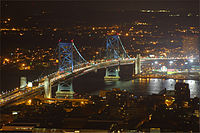
The Benjamin Franklin Bridge, originally named the Delaware River Bridge and known locally as the Ben Franklin Bridge, is a suspension bridge across the Delaware River connecting Philadelphia, Pennsylvania, and Camden, New Jersey. Owned and operated by the Delaware River Port Authority, it is one of four primary vehicular bridges between Philadelphia and southern New Jersey, along with the Betsy Ross, Walt Whitman, and Tacony-Palmyra bridges. It carries Interstate 676/U.S. Route 30, pedestrians/cyclists, and the PATCO Speedline.

The Walt Whitman Bridge is a single-level suspension bridge spanning the Delaware River from Philadelphia in the west to Gloucester City in Camden County, New Jersey in the east. The bridge is named after American poet and essayist Walt Whitman, who resided in nearby Camden toward the end of his life.

The Port of Chester is an American port on the west bank of the Delaware River in Delaware County, Pennsylvania. Centered around Chester it ranges into Marcus Hook to the south and Eddystone to the north. It is part of the Delaware Valley port complex and lies between the Port of Wilmington and the Port of Philadelphia. Traditionally, shipbuilding and later automobile assembly were the mainstays of the port. It has since given way to other manufacturing and recreational activities, with Penn Terminals the only traditional maritime facility.