
The Indian National Satellite System or INSAT, is a series of multipurpose geostationary satellites launched by ISRO to satisfy telecommunications, broadcasting, meteorology, and search and rescue operations. Commissioned in 1983, INSAT is the largest domestic communication system in the Indo-Pacific Region. It is a joint venture of the Department of Space, Department of Telecommunications, India Meteorological Department, All India Radio and Doordarshan. The overall coordination and management of INSAT system rests with the Secretary-level INSAT Coordination Committee.
The Indian Space Research Organisation is the national space agency of India. It operates as the primary research and development arm of the Department of Space (DoS), which is directly overseen by the Prime Minister of India while the Chairman of ISRO also acts as the executive of DoS. ISRO is primarily responsible for performing tasks related to space-based operations, space exploration, international space cooperation and the development of related technologies. ISRO is one of the six government space agencies in the world that possesses full launch capabilities, can deploy cryogenic engines, can launch extraterrestrial missions and operate a large fleet of artificial satellites. ISRO is one of the four government space agencies to have soft landing (uncrewed) capabilities.
HAMSAT also known as HAMSAT INDIA, VU2SAT and VO-52 is a microsatellite weighing 42.5 kilograms (93.7 lb), providing amateur radio satellite communications services for Indian and international amateur radio operators. This satellite carries the in-orbit designation of VO-52, and is an OSCAR series satellite.

The National Technical Research Organisation (NTRO) is a technical intelligence agency of India. It was set up in 2004. The agency reports to the National Security Advisor and to the Prime Minister's Office. NTRO also comprises the National Critical Information Infrastructure Protection Centre and the National Institute of Cryptology Research and Development.
Defence Electronics Research Laboratory (DLRL) is a laboratory of the Defence Research & Development Organization (DRDO). Located in Hyderabad, it is actively involved in the design and development of integrated Electronic Warfare systems for the Indian Armed Forces.
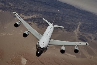
Signals intelligence operational platforms are employed by nations to collect signals intelligence, which is intelligence-gathering by interception of signals, whether between people or between machines, or mixtures of the two. As sensitive information is often encrypted, signals intelligence often involves the use of cryptanalysis. However, traffic analysis—the study of who is signalling whom and in what quantity—can often produce valuable information, even when the messages themselves cannot be decrypted.
Cartosat-2A is an Earth observation satellite in a Sun-synchronous orbit and the third of the Cartosat series of satellites. The satellite is the thirteenth satellite in the Indian Remote Sensing (IRS) satellite series to be built, launched by the Indian Space Research Organisation.

The DRDO Airborne Early Warning and Control System (AEW&CS) is a project of India's Defence Research and Development Organisation to develop an airborne early warning and control system for the Indian Air Force. It is also referred to as NETRA Airborne Early Warning and Control System (AEW&CS).
The Integrated Space Cell was the nodal agency within the Government of India with oversight of the security of its space based military and civilian hardware systems. It was to be jointly operated by all the three services of the Indian Armed Forces, the civilian Defence Research and Development Organisation and the Indian Space Research Organisation (ISRO). This agency was superseded by Defence Space Agency in 2019.[better source needed]

RISAT (Radar Imaging Satellite) is a series of Indian radar imaging reconnaissance satellites built by the Indian Space Research Organization (ISRO). They provide all-weather surveillance using synthetic aperture radars (SAR).

Svalbard Satellite Station or SvalSat is a satellite ground station located on Platåberget near Longyearbyen in Svalbard, Norway. Opened in 1997, it is operated by Kongsberg Satellite Services (KSAT), a joint venture between Kongsberg Defence & Aerospace and the Norwegian Space Centre (NSC). SvalSat and KSAT's Troll Satellite Station (TrollSat) in Antarctica are the only ground stations that can see a low altitude polar orbiting satellite on every revolution as the Earth rotates. As of 2021, the facility consists of 100 multi-mission and customer-dedicated antennas which operate in the C, L, S, X and K bands. The station provides ground services to more satellites than any other facility in the world.
Airbus Defense and Space is the division of Airbus SE responsible for the development and manufacturing of the corporation's defense and space products, while also providing related services. The division was formed in January 2014 during the corporate restructuring of European Aeronautic Defense and Space (EADS), and comprises the former Airbus Military, Astrium, and Cassidian divisions. It is the world's second-largest space company after Boeing and one of the top ten defense companies in the world.

EgyptSat 2 was Egypt's second remote sensing Earth observation satellite. It was built by the Russian RSC Energia and the Egyptian NARSS while the incorporated cameras and payload was developed by OAO Peleng and NIRUP Geoinformatsionnye Sistemy in Belarus.
Cartosat-2C is an Earth observation satellite in a Sun-synchronous orbit (SSO) and is a fifth flight unit of Cartosat series of satellites. It is a geostationary satellite and appears stationary over a place on the earth. The satellite is built at space application centre Ahmedabad, launched and maintained by the Indian Space Research Organisation (ISRO). It was launched on 22 June 2016.

EMISAT, launched on 1 April 2019, is an Indian reconnaissance satellite under Defence Research and Development Organisation (DRDO) project Kautilya which is a package that provides space-based electronic signal intelligence or ELINT. The spacecraft helps in improving the situational awareness of the Indian Armed Forces as it will provide information and location of enemy radars. The ELINT payload is developed by Defence Electronics Research Laboratory (DLRL), while augmented Indian Mini Satellite-2 (IMS-2) platform is provided by Indian Space Research Organisation (ISRO). The capabilities of the Kautilya package is highly classified. It monitors radio signals to determine the location and source of all transmission.

On 27 March 2019, India tested an anti-satellite weapon (ASAT) during an operation code named Mission Shakti. The target of the test was a satellite present in a low Earth orbit, which was hit with a kinetic kill vehicle.
The Defence Space Agency (DSA) is a tri-service agency of the Indian Armed Forces. Headquartered in Bengaluru, Karnataka, India. The agency is tasked with operating the space-warfare and Satellite Intelligence assets of India. The DSA draws personnel from all three branches of the Armed Forces.

The Integrated Coastal Surveillance System (ICSS) is a coastal surveillance system operated by India with the goal to protect its coastline, ensure regional security, and assist friendly navies by quickly detecting, locating and monitoring maritime activity in the Indian Ocean. The system was developed by the Defence Research and Development Organisation (DRDO) and Bharat Electronics, and forms part of the National Command Control Communication and Intelligence System (NC3I). Although the ICSS was built primarily for coastal and maritime security, the system can also be used for vessel traffic management, harbour surveillance and navigation. The core of the ICSS is a network of remote ground-based radar stations called the Coastal Surveillance Network (CSN). In addition to radars, stations are also fitted with optical sensors, electro-optical sensors, thermal imagers, cameras, meteorological systems, an Automatic Identification System (AIS), a distress alert transmission system (DATS), electronic warfare support measures, and very high frequency (VHF) radio communication systems.