Concord, Alabama

Last updated

Concord, Alabama
CDP
Jefferson County Alabama Incorporated and Unincorporated areas Concord Highlighted.svg
Location in Jefferson County and the state of Alabama
Coordinates: 33°28′8″N87°2′17″W / 33.46889°N 87.03806°W / 33.46889; -87.03806
Country United States
State Alabama
County Jefferson
Area
[1]
  Total3.38 sq mi (8.76 km2)
  Land3.37 sq mi (8.72 km2)
  Water0.02 sq mi (0.04 km2)
Elevation
585 ft (178 m)
Population
 (2020)
  Total1,690
  Density502.23/sq mi (193.89/km2)
Time zone UTC-6 (Central (CST))
  Summer (DST) UTC-5 (CDT)
ZIP code
35023
Area code(s) 205, 659
FIPS code 01-16936
GNIS feature ID0116480

Concord is a census-designated place in Jefferson County, Alabama, United States. At the 2010 census the population was 1,837, up from 1,809 in 2000. It is northwest from the Birmingham suburb of Hueytown.

Contents

Tuscaloosa tornado damage April 27, 2011 Tuscaloosa tornado damage 27 April 2011.jpg
Tuscaloosa tornado damage April 27, 2011

Geography

Concord is located at 33°28′9″N87°2′17″W / 33.46917°N 87.03806°W / 33.46917; -87.03806 (33.469092, -87.038163). [2]

According to the U.S. Census Bureau, the CDP has a total area of 3.4 square miles (8.8 km2), of which 3.4 square miles (8.8 km2) is land and 0.04 square miles (0.10 km2) (0.59%) is water.

Demographics

Historical population
CensusPop.Note
2000 1,809
2010 1,8371.5%
2020 1,690−8.0%
U.S. Decennial Census [3]
1850 [4] 1860 [5] 1870 [6]
1880 [7] 1890-1900 [8]
1910 [9] 1920 [10] 1930 [11]
1940 [12] 1950 [13] 1960 [14]
1970 [15] 1980 [16] 1990 [17]
2000 [18] 2010 [19] 2020 [20]

2020 census

Concord, Alabama – Racial and ethnic composition
Note: the US Census treats Hispanic/Latino as an ethnic category. This table excludes Latinos from the racial categories and assigns them to a separate category. Hispanics/Latinos may be of any race.
Race / Ethnicity (NH = Non-Hispanic)Pop 2000 [21] Pop 2010 [22] Pop 2020 [20] % 2000% 2010% 2020
White alone (NH)1,7781,8001,55398.29%97.99%91.89%
Black or African American alone (NH)510370.28%0.54%2.19%
Native American or Alaska Native alone (NH)10390.55%0.16%0.53%
Asian alone (NH)4310.22%0.16%0.06%
Pacific Islander alone (NH)0010.00%0.00%0.06%
Some Other Race alone (NH)1060.06%0.00%0.36%
Mixed Race or Multi-Racial (NH)612700.33%0.65%4.14%
Hispanic or Latino (any race)59130.28%0.49%0.77%
Total1,8091,8371,690100.00%100.00%100.00%

As of the 2020 United States census, there were 1,690 people, 631 households, and 501 families residing in the CDP.

2010 census

As of the census [23] of 2010, there were 1,837 people, 817 households, and 573 families residing in the CDP. The population density was 536.6 inhabitants per square mile (207.2/km2). There were 791 housing units at an average density of 232.6 per square mile (89.8/km2). The racial makeup of the CDP was 98.34% White, 0.28% Black or African American, 0.55% Native American, 0.22% Asian, 0.28% from other races, and 0.33% from two or more races. 0.28% of the population were Hispanic or Latino of any race.

There were 754 households, out of which 27.8% had children under the age of 18 living with them, 66.5% were married couples living together, 7.6% had a female householder with no husband present, and 24.0% were non-families. 22.6% of all households were made up of individuals, and 12.1% had someone living alone who was 65 years of age or older. The average household size was 2.40 and the average family size was 2.81.

In the CDP, the population was spread out, with 19.8% under the age of 18, 7.5% from 18 to 24, 27.4% from 25 to 44, 27.2% from 45 to 64, and 18.1% who were 65 years of age or older. The median age was 42 years. For every 100 females, there were 91.0 males. For every 100 females age 18 and over, there were 88.3 males.

The median income for a household in the CDP was $63,150, and the median income for a family was $55,129. Males had a median income of $35,825 versus $26,406 for females. The per capita income for the CDP was $24,490. About 1.5% of families and 2.4% of the population were below the poverty line, including none of those under age 18 and 8.0% of those age 65 or over.

Related Research Articles

<span class="mw-page-title-main">Walker County, Alabama</span> County in Alabama, United States

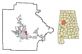
Walker County is a county located in the central portion of the U.S. state of Alabama. As of the 2020 census, the population was 65,342. Its county seat is Jasper. Its name is in honor of John Williams Walker, the first U.S. senator elected from Alabama.

<span class="mw-page-title-main">Saks, Alabama</span> Census-designated place & Unincorporated Community in Alabama, United States

Saks is a census-designated place (CDP) and Unincorporated community in Calhoun County, Alabama, United States. At the 2020 census, the population was 9,956. The community of Saks is served by the City of Anniston police and fire coverage. It is included in the Anniston-Oxford Metropolitan Statistical Area.

Selmont-West Selmont is a census-designated place (CDP) in Dallas County, Alabama, United States. At the 2020 census, the population was 2,158.

<span class="mw-page-title-main">Sylvania, Alabama</span> Town in Alabama, United States

Sylvania is a town in DeKalb County, Alabama, United States. It incorporated in October 1967. At the 2010 census the population was 1,837, up from 1,186 in 2000. Sylvania is located atop Sand Mountain. Sylvania was incorporated in 1967. The post office /town hall was built in 1977.

<span class="mw-page-title-main">McDonald Chapel, Alabama</span> CDP in Alabama, United States

McDonald Chapel is a census-designated place in Jefferson County, Alabama, United States. It is northeast of the Birmingham suburb of Pleasant Grove. At the 2020 census, the population was 739. Large portions of this area were damaged by violent tornadoes in 1956, 1998, and 2011. The 1998 tornado was rated F5 on the Fujita scale.

<span class="mw-page-title-main">Rock Creek, Alabama</span> CDP in Alabama, United States

Rock Creek is a census-designated place in Jefferson County, Alabama, United States. Its location is northwest of Hueytown. At the 2020 census, the population was 1,471. This area was damaged by an F5 tornado on April 8, 1998. An EF2 tornado struck northwest from here on January 23, 2012.

<span class="mw-page-title-main">Underwood-Petersville, Alabama</span> Census-designated place in Alabama, United States

Underwood-Petersville is a census-designated place (CDP) in Lauderdale County, Alabama United States. It is part of the Florence - Muscle Shoals Metropolitan Statistical Area known as "The Shoals". As of the 2010 census, the population of the CDP is 3,247.

<span class="mw-page-title-main">North Courtland, Alabama</span> Town in Alabama, United States

North Courtland is a town in Lawrence County, Alabama, United States, and is included in the Decatur Metropolitan Area, as well as the Huntsville-Decatur Combined Statistical Area. It incorporated in 1981. At the 2010 census, the population of the town was 632, down from 799 in 2000. Along with Hillsboro, it is one of two majority black communities in Lawrence County out of its six populated communities as of 2010.

<span class="mw-page-title-main">Holt, Alabama</span> Census-designated place & Unincorporated community in Alabama, United States

Holt is an unincorporated community and census-designated place (CDP) in Tuscaloosa County, Alabama, United States. At the 2020 census, the population was 3,413. It is part of the Tuscaloosa, Alabama Metropolitan Statistical Area. Holt appeared on the 1930 census.

<span class="mw-page-title-main">North Crossett, Arkansas</span> CDP in Arkansas, United States

North Crossett is a census-designated place (CDP) in Ashley County, Arkansas, United States. Per the 2020 census, the population was 2,756.

<span class="mw-page-title-main">Hensley, Arkansas</span> Census-designated place in Arkansas, United States

Hensley is a census-designated place (CDP) in Pulaski County, Arkansas, United States. The population was 139 at the 2010 census. It is part of the Little Rock–North Little Rock–Conway Metropolitan Statistical Area.

<span class="mw-page-title-main">Westwood Lakes, Florida</span> Census-designated place in Florida

Westwood Lakes is a census-designated place and unincorporated community of Miami-Dade County, Florida, United States. It is part of the Miami metropolitan area of South Florida. The population was 11,373 at the 2020 census.

Long Lake is an unincorporated community and census-designated place (CDP) in Lake County, Illinois, United States. Per the 2020 census, the population was 3,663.

<span class="mw-page-title-main">Frankfort Square, Illinois</span> Census-designated place in Illinois, United States

Frankfort Square is a census-designated place (CDP) in Will County, Illinois, United States. Per the 2020 census, the population was 8,968.

<span class="mw-page-title-main">Willow Brook Estates, Illinois</span> Census-designated place in Illinois, United States

Willow Brook Estates is an unincorporated census-designated place in Will County, Illinois, United States. The population was 1,346 at the 2020 census. it is considered a far south suburb of Chicago.

<span class="mw-page-title-main">New Hope, Mississippi</span> Census-designated place in Mississippi, United States

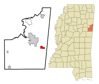
New Hope is a census-designated place (CDP) in Lowndes County, Mississippi, United States. As of the 2010 census, the CDP population was 3,193.

<span class="mw-page-title-main">Tucker, Mississippi</span> CDP in Mississippi, United States

Tucker is a census-designated place (CDP) in Neshoba County, Mississippi. It is one of the eight communities of the Mississippi Band of Choctaw Indians Reservation and the population is 93% Choctaw. The population was 642 at the 2020 census.

<span class="mw-page-title-main">Concord, Missouri</span> CDP in Missouri, United States

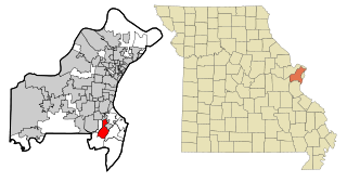
Concord is a census-designated place (CDP) in St. Louis County, Missouri, United States. The population was 16,421 at the 2010 census. It should not be confused with Concord Township, which the CDP shares much land with, but these areas' boundaries are not identical.

St. Bonaventure is a hamlet and census-designated place (CDP) in the town of Allegany in Cattaraugus County, New York, United States. The population was 1,963 at the 2020 census.

<span class="mw-page-title-main">Spring House, Pennsylvania</span> Census-designated place in Pennsylvania, United States

Spring House is a census-designated place (CDP) in Lower Gwynedd Township, Montgomery County, Pennsylvania, United States. The population was 3,978 at the 2020 census.

References

  1. "2020 U.S. Gazetteer Files". United States Census Bureau. Retrieved October 29, 2021.
  2. "US Gazetteer files: 2010, 2000, and 1990". United States Census Bureau. February 12, 2011. Retrieved April 23, 2011.
  3. "Decennial Census of Population and Housing by Decade" (PDF). United States Census Bureau.
  4. "1850 Census of Population - Alabama - Population of Civil Divisions less than Counties" (PDF). United States Census Bureau. 1850.
  5. "1860 Census of Population - Alabama - Population of Civil Divisions less than Counties" (PDF). United States Census Bureau. 1860.
  6. "1870 Census of Population - Alabama - Population of Civil Divisions less than Counties" (PDF). United States Census Bureau. 1870.
  7. "1880 Census of Population - Alabama - Population of Civil Divisions less than Counties" (PDF). United States Census Bureau. 1880.
  8. "1900 Census of Population - Alabama". United States Census Bureau. 1900.
  9. "1910 Census of Population - Alabama" (PDF). United States Census Bureau. 1910.
  10. "1920 Census of Population - Alabama" (PDF). United States Census Bureau. 1920. p. 178-179.
  11. "1930 Census of Population - Alabama" (PDF). United States Census Bureau. 1930. p. 139.
  12. "1940 Census of Population - Alabama" (PDF). United States Census Bureau. 1940.
  13. "1950 Census of Population - Alabama" (PDF). United States Census Bureau. 1950.
  14. "1960 Census of Population - Population of all incorporated places; and all unincorporated places of 1,000 or more - Alabama" (PDF). United States Census Bureau. 1960.
  15. "1970 Census of Population - Alabama" (PDF). United States Census Bureau. 1970.
  16. "1980 Census of Population - Alabama" (PDF). United States Census Bureau. 1980.
  17. "1990 Census of Population - Alabama" (PDF). United States Census Bureau. 1990.
  18. "2000 Census of Population - Summary Population and Housing Characteristics - Alabama" (PDF). United States Census Bureau. 2000.
  19. "2010 Census of Population - General Population Characteristics - Alabama" (PDF). United States Census Bureau. 2010.
  20. 1 2 "P2 Hispanic or Latino, and Not Hispanic or Latino by Race – 2020: DEC Redistricting Data (PL 94-171) – Concord CDP, Alabama". United States Census Bureau .
  21. "P004 Hispanic or Latino, and Not Hispanic or Latino by Race – 2000: DEC Summary File 1 – Concord CDP, Alabama". United States Census Bureau .
  22. "P2 Hispanic or Latino, and Not Hispanic or Latino by Race – 2010: DEC Redistricting Data (PL 94-171) – Concord CDP, Alabama". United States Census Bureau .
  23. "U.S. Census website". United States Census Bureau . Retrieved January 31, 2008.

33°28′09″N87°02′17″W / 33.469092°N 87.038163°W / 33.469092; -87.038163