Conference House

Last updated

Conference House
Conference-house-staten-island.jpg
USA New York City location map.svg
Red pog.svg
USA New York location map.svg
Red pog.svg
Usa edcp location map.svg
Red pog.svg
LocationConference House Park, Satterlee Street, Tottenville, Staten Island, New York City, New York
Coordinates 40°30′10.3″N74°15′13.6″W / 40.502861°N 74.253778°W / 40.502861; -74.253778
Area2.8 acres (1.1 ha)
Builtcirca 1675
Architectural style Dutch Colonial
Part of Ward's Point Conservation Area (ID82003402)
NRHP reference No. 66000566 [1]
NYSRHP No.08501.001286
NYCL No.0393
Significant dates
Added to NRHPOctober 15, 1966 [1]
Designated NHLMay 23, 1966 [2]
Designated CPSeptember 29, 1982
Designated NYSRHPJune 23, 1980

Conference House (also known as Billop House [3] ) is a stone house in the Tottenville neighborhood of Staten Island in New York City. Built by Captain Christopher Billopp some time before 1680, it is located in Conference House Park near Ward's Point, the southernmost tip of New York state, which became known as "Billop's Point" in the 18th century.

Contents

The Staten Island Peace Conference, an unsuccessful attempt to find a swift negotiated end to the American Revolutionary War, was hosted there by his heir and grandson, Colonel Christopher Billop, on September 11, 1776. The house, a National and New York City Landmark, is located at Conference House Park overlooking Raritan Bay. The house is also located within the Ward's Point Conservation Area, separately added to the National Register of Historic Places in 1982. [1] [4]

Construction

Captain Christopher Billopp, after years of distinguished service in the Royal Navy, came to America in 1674. He was granted a land patent on 932 acres (3.7 km2) on the southernmost tip of Staten Island. Archaeological evidence, including shell middens and digs conducted by The American Museum of Natural History in 1895, have shown that the Raritan band of the Lenape camped in the area and used the location as a burial ground. Known as Burial Ridge, it is the largest pre-European site in New York City.

Legend holds that sovereignty of Staten Island was determined by Capt. Billopp's skill in circling it in one day, earning it for New York rather than to New Jersey. [5] This has since been disproven and is in fact a myth.

In 1677, the fortunes of colonial service took Capt. Billopp to New Castle on the Delaware River, where he commanded the local garrison. Upon appointment of Thomas Dongan as governor of the colony of New York, he returned to Staten Island and became active in the local government. He was further rewarded by another patent, expanding his Staten Island property to 1,600 acres (6.4 km2).

It is difficult to ascertain exactly when his manor house was built, but one surviving map shows that a building existed on the site of the Conference House before 1680. The house was passed down to his great grandson Christopher Billop, who was commissioned a colonel and led Loyalist forces against the Colonials in the American Revolution.

American Revolution

Peace conference

On September 11, 1776, British loyalist Colonel Christopher Billop, commander of a Tory regiment in the conflict, hosted an informal diplomatic conference aimed at finding an early end to the nascent American Revolution. Lord Howe, commander in chief of British forces in America, arranged to meet with representatives of the Continental Congress in what is known today as the Staten Island Peace Conference. Benjamin Franklin, John Adams, and Edward Rutledge rowed over from patriot-held Perth Amboy, New Jersey. The meeting lasted for three hours and ended with the Americans politely declining the diplomatically handcuffed Howe's offer, leading to another seven years of conflict. [6]

Billop's Point

Conference House is situated on the southernmost point of New York State, at what was originally known as "Billop's Point", today's Ward's Point. It was from this site, where the mouth of Arthur Kill juts out into Raritan Bay, that a raid on October 25, 1779, known as "Simcoe's Raid", was conducted upon patriot-held New Jersey by John Graves Simcoe, leader of the Tory unit the Queen's Rangers. In A History Of The Operations Of A Partisan Corps Called The Queen's Rangers, which he wrote after the war, he mentions:

The batteaux, and boats, which were appointed to be at Billop's-point, so as to pass the whole over by twelve o'clock at night, did not arrive till three o'clock in the morning.

Billop's point is mentioned in the journal of Major André:

Oct. 25 The Regiments at Amboy received Orders to strike their tents and send them with their baggage to the water's side. Those at Staten Island had orders to leave theirs standing, and repair by 8 o'clock in the evening to Billop's Point.

Confiscation

After the cessation of hostilities and British withdrawal from the former colonies the house was confiscated by the state of New York with no recompense to the Billop family. However, many who suffered confiscation, particularly those who were regarded as most notorious by the rebels, later received some form of compensation from the British government. [7]

Notable visitors

Encamped during the Revolution

Conservation

After the revolution, most of the Billops went to Canada. One hundred years after the conference the house was used as a hotel, and a rat poison factory, [8] before subsequently being abandoned and vandalized. In 1901 Assemblyman Van Name of Richmond County, New York, introduced a bill to acquire the house and mark it for historic preservation. [9] However, the house was not immediately recognized for preservation.[ citation needed ]

The city finally acquired the house in 1926, at which point it was in danger of being razed. [10] [11] Conference House Park was created the same year. [12] A nonprofit organization, the Conference House Association, was formed; in 1929, the Municipal Assembly of the City of New York placed the house under the association's aegis. The association subsequently restored the house in a series of small projects, which included building a new roof as well as stairs from the first floor to the basement, painting the facade, and restoring the old well. The second floor was then restored, and a floor in the attic was created. The project was completed in 1937, and the house was dedicated on May 15, 1937. [11] The house was declared a National Historic Landmark in 1966. [2] [6] [13]

See also

Related Research Articles

<span class="mw-page-title-main">Staten Island</span> Borough in New York City

Staten Island is the southernmost borough of New York City, coextensive with Richmond County and situated at the southern tip of the U.S. state of New York. The borough is separated from the adjacent state of New Jersey by the Arthur Kill and the Kill Van Kull and from the rest of New York by New York Bay. With a population of 495,747 in the 2020 Census, Staten Island is the least populated New York City borough but the third largest in land area at 58.5 sq mi (152 km2); it is also the least densely populated and most suburban borough in the city.

<span class="mw-page-title-main">Tottenville, Staten Island</span> Neighborhood of Staten Island in New York City

Tottenville is a neighborhood on the South Shore of Staten Island, New York City. It is the southernmost neighbourhood and settlement in both New York City and New York State, as well as the westernmost neighbourhood in New York City. Tottenville is bounded on three sides by water: the south side abuts the New York Bight while the west and north sides are bordered by the Arthur Kill. Nassau Place, Bethel Avenue and Page Avenue form the neighborhood's eastern border.

<span class="mw-page-title-main">South Shore, Staten Island</span>

The South Shore is a geographical term applied to the area in the New York City borough of Staten Island, south and east of the island's ridge of hills along the waterfront and adjacent areas from the Narrows to the mouth of the Arthur Kill. Many observers prefer to restrict its scope to the neighborhoods located between the shoreline of Raritan Bay on one side and Richmond Creek and Fresh Kills on the other, thus encompassing the neighborhoods of Great Kills to Tottenville only. Those who use this narrower definition of the "South Shore" prefer the term "East Shore" for the communities that lie along Lower New York Bay, and inland for approximately 2 to 2+12 miles, from Bay Terrace and Richmondtown to as far north as Grasmere and Concord. The South Shore is represented in the New York City Council by Joe Borelli.

<span class="mw-page-title-main">New York and New Jersey campaign</span> Campaign in the American Revolutionary War

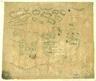
The New York and New Jersey campaign in 1776 and the winter months of 1777 was a series of American Revolutionary War battles for control of the Port of New York and the state of New Jersey, fought between British forces under General Sir William Howe and the Continental Army under General George Washington. Howe was successful in driving Washington out of New York, but overextended his reach into New Jersey, and ended the New York and New Jersey campaign in January 1777 with only a few outposts near New York City under British control. The British held New York Harbor for the rest of the Revolutionary War, using it as a base for expeditions against other targets.

<span class="mw-page-title-main">New Utrecht, Brooklyn</span> Former town in Long Island, New York

New Utrecht was a town in western Long Island, New York encompassing all or part of the present-day Bath Beach, Bay Ridge, Bensonhurst, Borough Park, Dyker Heights and Fort Hamilton neighborhoods of Brooklyn, New York City. New Utrecht was established in 1652 by Dutch settlers in the Dutch colony of New Netherland, the last of the original six towns to be founded in Kings County. New Utrecht ceased to exist in 1894 when it was annexed by the City of Brooklyn, and became part of the City of Greater New York when Brooklyn joined as a borough in 1898.

<span class="mw-page-title-main">Ward's Point</span> United States historic place

Ward's Point is the southernmost point in the U.S. state of New York and lies within Tottenville, Staten Island, New York City. It is located at the mouth of Arthur Kill, across from Perth Amboy, New Jersey, at the head of Raritan Bay. The site is part of modern-day Conference House Park.

Prince's Bay is the name of a neighborhood located on the South Shore of New York City's borough of Staten Island. Prince's Bay is bordered to the north by Huguenot, to the south by the Raritan Bay, and to the west by Pleasant Plains. The neighborhood is represented in the New York State Senate by Andrew Lanza, in the New York State Assembly by Michael Reilly, and in the New York City Council by Joe Borelli.

<span class="mw-page-title-main">Middlebrook encampment</span> United States historic place

"Middlebrook encampment" may refer to one of two different seasonal stays of the Continental Army in central New Jersey near the Middlebrook in Bridgewater Township in Somerset County. They are usually differentiated by either the date of the encampment or their chronological order.

<span class="mw-page-title-main">Old Queens</span> United States historic place

Old Queens is the oldest extant building at Rutgers University and is the symbolic heart of the university's campus in New Brunswick in Middlesex County, New Jersey in the United States. Rutgers, the eighth-oldest college in the United States, was founded in 1766 during the American colonial period as Queen's College. Queen's College was named for Charlotte of Mecklenburg-Strelitz, the daughter of a German duke who became the queen consort of British king George III. Old Queens is located on a six-acre hilltop city block bounded by Somerset Street, Hamilton Street, College Avenue and George Street that was previously an apple orchard. Donated to the college in 1807 by James Parker, Jr., this city block become known the Queen's Campus and is the historic core of the university. Because of this, by metonymy, the name "Old Queens" came to be used as a reference to Rutgers College and is often invoked as an allusive reference to the university or to its administration.

<span class="mw-page-title-main">Battle of Short Hills</span> Battle of the American Revolutionary War

The Battle of the Short Hills was a conflict between a Continental Army force commanded by Brigadier General William Alexander, and an opposing British force commanded by Lieutenant General William Howe. The battle took place on June 26, 1777, at Scotch Plains and Edison, New Jersey, during the American Revolutionary War.

<span class="mw-page-title-main">Edward Sargent (architect)</span> American architect

Edward A. Sargent was an English-born American architect, known for his work on New York City schools, churches, office buildings, clubs, armory and country homes.

<span class="mw-page-title-main">Conference House Park</span> Public park in Staten Island, New York

<span class="mw-page-title-main">Christopher Billop</span> Canadian politician

Christopher Billopp was a British loyalist during the American Revolution. His command of a Tory detachment during the war earned him the sobriquet, "Tory Colonel". After the American Revolution he emigrated to New Brunswick, Canada along with other Loyalists and became a politician. He represented Saint John in the 1st New Brunswick Legislative Assembly.

<span class="mw-page-title-main">Staten Island Peace Conference</span> 1776 diplomatic meeting between Britain and its rebellious North American colonies

The Staten Island Peace Conference was a brief informal diplomatic conference held between representatives of the British Crown and its rebellious North American colonies in the hope of bringing a rapid end to the nascent American Revolution. The conference took place on September 11, 1776, a few days after the British had captured Long Island and less than three months after the formal American Declaration of Independence. The conference was held at Billop Manor, the residence of loyalist Colonel Christopher Billop, on Staten Island, New York. The participants were the British Admiral Lord Richard Howe, and members of the Second Continental Congress John Adams, Benjamin Franklin, and Edward Rutledge.

<span class="mw-page-title-main">Christopher House (Staten Island)</span>

The Christopher House is a stone masonry farmhouse at Historic Richmond Town in Staten Island, New York City. It is associated with two of the oldest Staten Island families. It was also used as a meeting place during the American Revolution, while being the residence of Joseph Christopher, a member of the Richmond County Committee of Safety from 1775 to 1776. It was moved to Historic Richmond Town in late 1969 and restored for museum presentation from 1975 to 1977.

<span class="mw-page-title-main">Olmsted–Beil House</span>

The Olmsted–Beil House was a large farm and modest Dutch farmhouse at 4515 Hylan Boulevard in the South Shore of Staten Island, New York City. The house was purchased by Frederick Law Olmsted's father and given to Olmsted in 1848 to grow crops, plant trees and clear for pasture for livestock. It is on one of the higher hills overlooking Raritan Bay, and Sandy Hook in New Jersey.

<span class="mw-page-title-main">Christopher Billopp (Royal Navy officer)</span> Royal Navy officer

Christopher Billopp or Billop was an English officer of the Royal Navy in the seventeenth century who commanded various ships of the line, including HMS Greenwich in the Battle of Bantry Bay. He is noted as part of the "Staten Island Legend", a likely apocryphal story which describes Billopp's circumnavigation of Staten Island in a sailing race to claim it for New York. Though the legend has survived in oral tradition and popular culture since at least the 19th century, there is no concrete evidence that such a race actually occurred.

<span class="mw-page-title-main">Philipse Manor Hall State Historic Site</span> Historic house in New York, United States

Philipse Manor Hall State Historic Site is a historic house museum located in the Getty Square neighborhood of Yonkers, New York. Originally the family seat of Philipse Manor, it is Westchester County's second oldest standing building after the Timothy Knapp House. Located near the Hudson River at Warburton Avenue and Dock Street, it is owned and operated by the New York State Office of Parks, Recreation and Historic Preservation.

<span class="mw-page-title-main">Staten Island Borough Hall</span> United States historic place

Staten Island Borough Hall is the primary municipal building for the borough of Staten Island in New York City. It is located at 10 Richmond Terrace, next to the Richmond County Courthouse and opposite the St. George Terminal of the Staten Island Ferry. Borough Hall houses the Borough President's office, offices of the Departments of Buildings and Transportation, and other civic offices.

<span class="mw-page-title-main">Perth Amboy Ferry Slip</span> United States historic place

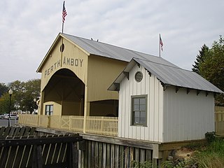
The Perth Amboy Ferry Slip, located on the Arthur Kill in Perth Amboy, Middlesex County, New Jersey, United States, was once a vital ferry slip for boats in New York Harbor. It was added to the New Jersey Register of Historic Places and National Register of Historic Places in 1978. The ferry slip was restored in 1998 to its 1904 appearance. A replica of the ticket office has been constructed and is used as a small museum.

References

  1. 1 2 3 "National Register Information System". National Register of Historic Places . National Park Service. July 9, 2010.
  2. 1 2 "Conference House". National Historic Landmark . National Park Service. September 10, 2007. Archived from the original on October 10, 2012. Retrieved September 11, 2007. On 11 September 1776, this was the scene of a meeting between Lord Richard Howe and a committee of the Continental Congress. The British Admiral offered amnesty in exchange for withdrawal of the Declaration of Independence.
  3. White, Norval & Willensky, Elliot (2000). AIA Guide to New York City (4th ed.). New York: Three Rivers Press. p. 931. ISBN   978-0-8129-3107-5.
  4. Charles A. Florence (June 1982). "National Register of Historic Places Registration: Ward's Point Conservation Area". New York State Office of Parks, Recreation and Historic Preservation . Retrieved December 6, 2010.See also: "Accompanying 13 photos".
  5. Connelly, James C (October 1923). "How New York Acquired Staten Island" (PDF). Proceedings of the New Jersey Historical Society. New Series. 8 (4). Retrieved June 30, 2012.
  6. 1 2 "Conference (Billopp) House" (PDF). National Register of Historic Places . National Park Service. November 20, 1975.
  7. See Tory military leader Beverley Robinson and Frederick Philipse III, the final lord of Philipsburg Manor.
  8. Kaye, Nick (May 12, 2006). "Tracing the Revolution Across Staten Island". The New York Times. Retrieved May 18, 2019.
  9. "A Bill for the Preservation of the Historic Mansion. Continental Congress Committee There Rejected Lord Howe's Offer of Amnesty". The New York Times . April 7, 1901. Retrieved August 3, 2008. Assemblyman Van Name of Richmond has introduced a bill in the Assembly for the preservation of the building known as the Billop House, in the County of Richmond, and to authorize the acquisition of the title thereto, and the lands adjacent, for historical purposes. The Billop House, which is a stone structure erected by Christopher Billop before the Revolution, was the scene of one of the most momentous interviews in American history.
  10. "City Will Preserve Old Billop House. Landmark at Tottenville, S.I., Was Scene of Peace Conference in '76. Given by Realty Co". The New York Times. April 20, 1926. Retrieved August 3, 2008.
  11. 1 2 "History -". The Conference House. Retrieved May 18, 2019.
  12. "Conference House Park Historic Houses : NYC Parks". www.nycgovparks.org. Retrieved May 17, 2019.
  13. "National Register of Historic Places Inventory" (PDF). National Register of Historic Places . National Park Service. November 20, 1975.

"September 11th, 1776 - America's First Attempt at Peace" Authors Ernest and Gregory Schimizzi, Albany, 1976, New York State Bicentennial Commission, http://wvvh.com/images/Sept_11_1776.pdf