
The national parks of New Zealand are protected natural areas administered by the Department of Conservation (DOC). Although the national parks contain some of New Zealand's most beautiful scenery, the first few established were all focused on mountain scenery. Since the 1980s the focus has been on developing a more diverse representation of New Zealand landscapes. The parks are all culturally significant and many also contain historic features. Tongariro National Park is one of the World Heritage Sites that are of both cultural and natural significance, while four of the South Island national parks form Te Wahipounamu, another World Heritage Site. There are currently 13 national parks; a 14th, Te Urewera National Park, was disestablished in 2014.

In Māori mythology, Tāne is the god of forests and of birds, and the son of Ranginui and Papatūānuku, the sky father and the earth mother, who used to lie in a tight embrace where their many children lived in the darkness between them.

The Department of Conservation is the public service department of New Zealand charged with the conservation of New Zealand's natural and historical heritage.
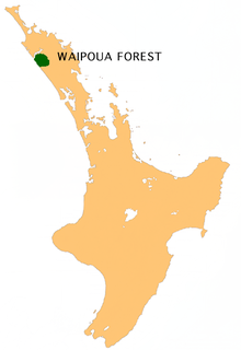
Waipoua Forest is a forest, on the west coast of the Northland Region of New Zealand's North Island. It preserves some of the best examples of kauri forest remaining in New Zealand. It is notable for having two of the largest living kauri trees, Tāne Mahuta and Te Matua Ngahere.

The Rangitaiki River is the longest river in the Bay of Plenty region in New Zealand's North Island. It is 155 kilometres (96 mi) long, and rises inland from northern Hawkes Bay to the east of the Kaingaroa Forest. The Rangitaiki catchment covers an area of 3005 km2. It flows in a generally northeastward direction, passing through the town of Murupara and skirting close to the western edge of Te Urewera National Park before turning northwards, flowing past Edgecumbe and into the Bay of Plenty close to Thornton.

Murupara is a town located in the Whakatāne District and Bay of Plenty Region of New Zealand's North Island. The town is situated in an isolated part of the region between the Kaingaroa Forest and Te Urewera protected area, on the banks of the Rangitaiki River, 65 kilometres southeast of Rotorua.

Protected areas of New Zealand receive protection to preserve their environmental, historical or cultural value. The method and aims of protection vary according to the importance of the resource and whether it has public or private status. Nearly 30 percent of the land mass of New Zealand is in public ownership and has some degree of protection; these areas include conservation parks, mainland islands, island reserves, marine reserves, and national parks.

The environmental movement in New Zealand started in the 1950s, a period of rapid social change. Since then numerous high-profile national campaigns have contested various environmental issues. The environmental movement eventually spawned the Values Party, which was the first political party with a strong focus on environmental issues to contest national elections. The Values Party eventually morphed into the Green Party of Aotearoa New Zealand.

Whirinaki Te Pua-a-Tāne Conservation Park is a publicly accessible conservation park in the North Island of New Zealand. The park is centered on the town of Minginui and part of the eastern boundary flanks Te Urewera. The Whirinaki Forest is one of the world's last prehistoric rainforests.
Ngāti Whare is a Māori iwi of New Zealand. It is part of a group of tribes participating in the "treelords" Treaty of Waitangi settlement with the New Zealand government involving Central North Island forestry land and cash.
The Moerangi River or Moerangi Stream is found in New Zealand's Whirinaki Te Pua-a-Tāne Conservation Park. It is a fairly small river but is one of the main tributaries of the Waiau River, Hawke's Bay. The river is used by trampers (hikers), fisherman and hunters.

State Highway 38 is a road in the North Island of New Zealand that starts from SH 5 near Waiotapu, and ends at Wairoa, where it connects to SH 2. It is the shortest connection from the central North Island (Rotorua) to the East Coast (Gisborne), but it is not often used as such. Large parts of the road are narrow and winding, and about 74 kilometres (46 mi) of the road is unsealed. Travel on this highway takes roughly four hours.
Minginui is a town in Whakatāne District and Bay of Plenty Region on New Zealand's North Island.
The Whirinaki River is a river of the Hawke's Bay and Bay of Plenty Regions of New Zealand's North Island. It flows generally north through the Whirinaki Te Pua-a-Tāne Conservation Park and Kaingaroa Forest to reach the Rangitaiki River 3 kilometres (2 mi) north of Murupara.
Rex Forrester was a recognised New Zealand hunting and fishing specialist. He was known for his deer culling, helicopter hunting, live deer capture, pig hunting and trout fishing within New Zealand and Australia. He was also an outdoor sports author who published nine books.
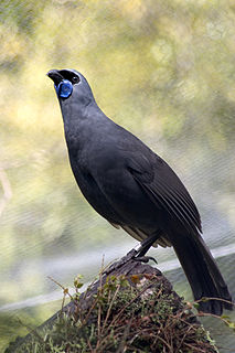
The North Island kōkako is an endangered forest bird which is endemic to the North Island of New Zealand. It is grey in colour, with a small black mask. It has blue wattles. Because of its wattle, the bird is sometimes locally called the blue-wattled crow, although it is not a corvid.

Te Whaiti or Te Whāiti is a forested area in the Whakatāne District and Bay of Plenty Region of New Zealand's North Island. It is located in the Whirinaki River Valley, near Minginui.

Arohaki Lagoon is a small ephemeral lagoon located in the Whakatāne District of the North Island, New Zealand. It is within the Whirinaki Te Pua-a-Tāne Conservation Park, south and can be accessed via a 6-kilometre (3.7 mi) walking track.

A sanctuary area is a type of New Zealand protected area. They exist to preserve populations of important forest types, like the remnants of Kauri forests in Northland.
