
Arthur's Pass National Park is located in the South Island of New Zealand and covers 1,185 km2 of mostly mountainous terrain. Adjacent to it lies Craigieburn Forest Park. The park is administered by the Department of Conservation.

Kaiapoi is a town in the Waimakariri District of the Canterbury region, in the South Island of New Zealand. The town is located approximately 17 kilometres north of central Christchurch, close to the mouth of the Waimakariri River. It is considered a satellite town of Christchurch and is part of the Christchurch functional urban area.

The Waimakariri River is one of the largest rivers in Canterbury, on the eastern coast of New Zealand's South Island. It flows for 151 kilometres (94 mi) in a generally southeastward direction from the Southern Alps across the Canterbury Plains to the Pacific Ocean.

The Ōpāwaho / Heathcote River lies within the city boundaries of Christchurch, New Zealand, and is fed from springs near Templeton Road, with a catchment area in wet weather extending as far west as Yaldhurst and Pound Road. It meanders around the base of the Port Hills from west to south-east.

The Rakaia River is in the Canterbury Plains in New Zealand's South Island. The Rakaia River is one of the largest braided rivers in New Zealand. The Rakaia River has a mean flow of 203 cubic metres per second (7,200 cu ft/s) and a mean annual seven-day low flow of 87 m3/s (3,100 cu ft/s). In the 1850s, European settlers named it the Cholmondeley River, but this name lapsed into disuse. The name Rakaia comes from Māori "Ō Rakaia", meaning the place where people were arranged by ranks

The Ashley River is in the Canterbury region of New Zealand. It flows generally southeastwards for 65 kilometres (40 mi) before entering the Pacific Ocean at Waikuku Beach, Pegasus Bay north of Christchurch. The town of Rangiora is close to the south bank of the Ashley River. The river's official name was changed from Ashley River to the dual name Ashley River / Rakahuri by the Ngāi Tahu Claims Settlement Act 1998.

Waimakariri District is a local government district, located in the Canterbury Region of New Zealand's South Island. It is named after the Waimakariri River, which forms the district's southern boundary, separating it from Christchurch City and the Selwyn District. It is bounded in the north by the Hurunui District and in the east by the Pacific Ocean.

Regional parks of New Zealand are protected areas administered by regional councils, the top tier of local government. Regional parks are found across five regions of New Zealand: the Auckland Region, Waikato Region, Bay of Plenty Region, Wellington Region and Canterbury Region. Regional parks in the Auckland and Waikato regions are administered by the Auckland Council, while parks in other areas are administered by regional councils: the Bay of Plenty Regional Council, Greater Wellington Regional Council, and Canterbury Regional Council.

Environment Canterbury, frequently abbreviated to ECan, is the promotional name for the Canterbury Regional Council. It is the regional council for Canterbury, the largest region in the South Island of New Zealand. It is part of New Zealand's structure of local government.

Woodend is a town in the Waimakariri District, in the Canterbury Region of the South Island of New Zealand. It may have been named because it was on the edge of what was then called the Maori Bush, or after an early settler, Thomas Wooding. It is situated with both the Waimakariri and Ashley / Rakahuri Rivers running either side. Woodend is 6.6 kilometres north of Kaiapoi and 6.3 kilometres to the east of Rangiora. Woodend is within walking distance of the town of Pegasus.

Kaitoke Regional Park is regional park located at Kaitoke, northeast of Upper Hutt, in the Wellington Region of New Zealand's southern North Island. It is administered by Wellington Regional Council, alongside the adjacent Hutt Water Collection Area.

In 2004 Didymosphenia geminata, a diatom commonly known as didymo or rock snot, was discovered in New Zealand, the first time it was found in the Southern Hemisphere. To restrict its spread, the whole of the South Island of New Zealand was declared a controlled area in December 2005. All items, such as boats, fishing gear, clothing, and vehicles, that have been in a stream, river or lake, must be cleaned before they enter another waterway. Biosecurity New Zealand working with Environment Southland, AgriQuality and Fish and Game New Zealand launched an extensive public awareness campaign to encourage river users to clean their equipment after use in affected waterways. This campaign was highly successful, with 99% of freshwater users surveyed in 2008 in the South Island being aware of didymo.

Brooklands Lagoon is technically a very elongated estuary near Brooklands, Christchurch. The Styx river drains into it and it is at the mouth of the Waimakariri river. The Waimakariri used to drain out of Brooklands Lagoon towards the Spencer Park end. This changed when engineers dug through the sand dunes to provide a more direct course to the sea in 1930 in order to reduce the risk of flooding from the Waimakariri River. The Lagoon is protected from the Pegasus Bay by Brooklands Spit. To the south of it is Bottle Lake Forest and Spencer Park. The lagoon is approximately 270 hectares in size, 4.5 kilometers long and 800 meters at its widest. Spring tides will bring approximately 1.6 million cubic meters of water into the lagoon.

Norman Kirk Park is a recreational space on the east side of Kaiapoi which is a town in the Waimakariri District of Canterbury, New Zealand. Norman Kirk Park was built on former red zone land that was a residential neighbourhood prior to the Canterbury earthquakes of 2010 and 2011. Norman Kirk Park consists of a dog park, a nature reserve, sports fields, and a BMX track.
McLeans Island is a rural area north and northwest of Christchurch city, and south of Waimakariri River.

Whitireia Park is a headland north of Tītahi Bay and Te Awarua-o-Porirua Harbour in Porirua, in the Wellington Region at the southern end of New Zealand's North Island. It is a park administered by the Whitireia Park Board, in collaboration with Wellington Regional Council. The park includes Onehunga Bay, Kaitawa Point and part of Rocky Bay.

Punakaiki Marine Reserve is a marine reserve administered by the Department of Conservation. The reserve includes the area of sea surrounding the pancake rocks and blowholes at Dolomite Point, at Punakaiki on the West Coast Region of New Zealand's South Island. It also includes most of the coastline on the western edge of Paparoa National Park.

Ashley Rakahuri Regional Park is a regional park in the Canterbury Region of New Zealand's South Island. It covers 417 hectares on the banks of Ashley River / Rakahuri and Okuku River, and is operated by Environment Canterbury. The park is used for fishing, walking, swimming, cycling and family picnics.
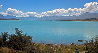
Lake Tekapo Regional Park is a regional park in the Canterbury Region of New Zealand's South Island. It covers 165 hectares at the eastern side of the southern end of Lake Tekapo, east of the Lake Tekapo township. It is the newest of the four Canterbury regional parks managed by Environment Canterbury.

Northern Pegasus Bay is a regional park in the northern part of Canterbury's Pegasus Bay in New Zealand's South Island. It is operated by Environment Canterbury.

