Cote Sans Dessein Township, Callaway County, Missouri

Last updated

Cote Sans Dessein Township
Map highlighting Cote Sans Dessein Township, Callaway County, Missouri.svg
Coordinates: 38°38′18″N092°00′07″W / 38.63833°N 92.00194°W / 38.63833; -92.00194
Country United States
State Missouri
County Callaway
Area
  Total48.82 sq mi (126.43 km2)
  Land47.29 sq mi (122.49 km2)
  Water1.52 sq mi (3.95 km2)  3.12%
Elevation
[1]
551 ft (168 m)
Population
 (2010)
  Total1,122
  Density23/sq mi (8.9/km2)
FIPS code 29-16642 [2]
GNIS feature ID 0766376

Cote Sans Dessein Township is one of eighteen townships in Callaway County, Missouri, USA. As of the 2010 census, its population was 1,122. [3]

Contents

Geography

Today, Cote Sans Dessein Township covers an area of 48.82 square miles (126.4 km2) and, as of 2018, contains no incorporated settlements, but does include the unincorporated community of Tebbetts and the historic riverbank settlements of Cote Sans Dessein and Barkersville (west of Cote Sans Dessein settlement with a post office and school as of 1876), as well as historic Effie (inland and northeast of Tebbetts), plus rural homes. It contains six cemeteries: Farmer, High Hill, Middle River, Riverview, Thorp and Williams, and The streams of Cason Branch, Gallons Creek, Muddy Creek, Rivaux Creek, Rocky Branch, and Sand Springs Branch.

The township's eastern boundary is formed by the Missouri River tributary of Middle River, and the Missouri River tributary of Little Auxvasse Creek also flows through the township.

A detailed historic map of Callaway County townships in 1930 can be found at http://cdm16795.contentdm.oclc.org/cdm/ref/collection/moplatbooks/id/656 . This is useful for historical and genealogical research. Maps and text descriptions of Callaway townships prior to that date can be found under the article for Callaway County, Missouri.

History

Cote Sans Dessein Township was established in 1821, and named after the community of Cote Sans Dessein, Missouri. [4] The township included nearly all of western Callaway County at the time of its establishment, but within only a few months its size became reduced as a result of the creation of new townships up and down western Callaway (per the Missouri State Library's "History of Callaway County" published in 1884, which gives text descriptions of the boundaries).

Related Research Articles

<span class="mw-page-title-main">Callaway County, Missouri</span> County in Missouri, United States

Callaway County is a county located in the U.S. state of Missouri. As of the 2020 United States Census, the county's population was 44,283. Its county seat is Fulton. With a border formed by the Missouri River, the county was organized November 25, 1820, and named for Captain James Callaway, grandson of Daniel Boone. The county has been historically referred to as "The Kingdom of Callaway" after an incident in which some residents confronted Union troops during the U.S. Civil War.

<span class="mw-page-title-main">Auxvasse, Missouri</span> City in Missouri, United States

Auxvasse is a city in northern Callaway County, Missouri, United States. It is part of the Jefferson City, Missouri Metropolitan Statistical Area. The population was 983 at the 2010 census.

<span class="mw-page-title-main">Fulton, Missouri</span> City in Missouri, United States

Fulton is the largest city in and the county seat of Callaway County, Missouri, United States. Located about 22 miles (35 km) northeast of Jefferson City and the Missouri River and 20 miles (32 km) east of Columbia, the city is part of the Jefferson City, Missouri, Metropolitan Statistical Area. The population was 12,790 in the 2010 census. The city is home to two universities, Westminster College and William Woods University; the Missouri School for the Deaf; the Fulton State Hospital; and the Fulton Reception and Diagnostic Center state prison. Missouri's only nuclear power plant, the Callaway Plant is located 13 miles southeast of Fulton.

<span class="mw-page-title-main">Tebbetts, Missouri</span> Census-Designated Place in Missouri, United States

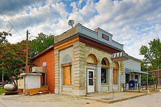
Tebbetts is an unincorporated community in southern Callaway County, Missouri, United States. It is part of the Jefferson City, Missouri Metropolitan Statistical Area. Tebbetts is located on Route 94, approximately 8 miles (13 km) east of Jefferson City, on the north edge of the Missouri River floodplain.

<span class="mw-page-title-main">Auxvasse Township, Callaway County, Missouri</span> Township in the American state of Missouri

Auxvasse Township is one of eighteen townships in Callaway County, Missouri, USA. As of the 2010 census, its population was 1,000.

<span class="mw-page-title-main">Bourbon Township, Callaway County, Missouri</span> Township in the American state of Missouri

Bourbon Township is one of eighteen townships in Callaway County, Missouri, USA. As of the 2010 census, its population was 2,059.

<span class="mw-page-title-main">Caldwell Township, Callaway County, Missouri</span> Township in the American state of Missouri

Caldwell Township is one of eighteen townships in Callaway County, Missouri, USA. As of the 2010 census, its population was 438.

<span class="mw-page-title-main">Calwood Township, Callaway County, Missouri</span> Township in the American state of Missouri

Calwood Township is one of eighteen townships in Callaway County, Missouri, USA. As of the 2010 census, its population was 1,097.

<span class="mw-page-title-main">Cedar Township, Callaway County, Missouri</span> Township in the American state of Missouri

NOTE: Cedar Township in Callaway County no longer contains the town of Cedar City since boundary changes creating Summit Township from its former southern sector sometime between 1883 and 1897. This has caused some confusion in historical, geographic, and genealogical research—see "History" section below.

<span class="mw-page-title-main">Cleveland Township, Callaway County, Missouri</span> Township in the American state of Missouri

Cleveland Township is one of eighteen townships in Callaway County, Missouri, USA. As of the 2010 census, its population was 742.

<span class="mw-page-title-main">East Fulton Township, Callaway County, Missouri</span> Township in the American state of Missouri

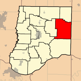
East Fulton Township is one of eighteen townships in Callaway County, Missouri, USA. As of the 2010 census, its population was 10,231.

<span class="mw-page-title-main">Jackson Township, Callaway County, Missouri</span> Township in the American state of Missouri

Jackson Township is one of eighteen townships in Callaway County, Missouri, USA. As of the 2010 census, its population was 2,150.

<span class="mw-page-title-main">Liberty Township, Callaway County, Missouri</span> Township in Missouri, United States

Liberty Township is one of eighteen townships in Callaway County, Missouri, USA. As of the 2010 census, its population was 840.

<span class="mw-page-title-main">McCredie Township, Callaway County, Missouri</span> Township in the American state of Missouri

McCredie Township is one of eighteen townships in Callaway County, Missouri, USA. As of the 2010 census, its population was 760.

<span class="mw-page-title-main">Nine Mile Prairie Township, Callaway County, Missouri</span> Township in the American state of Missouri

Nine Mile Prairie Township is one of eighteen townships in Callaway County, Missouri, USA. As of the 2010 census, its population was 790.

<span class="mw-page-title-main">Round Prairie Township, Callaway County, Missouri</span> Township in the American state of Missouri

Round Prairie Township is one of eighteen townships in Callaway County, Missouri, USA. As of the 2010 census, its population was 1038.

<span class="mw-page-title-main">St. Aubert Township, Callaway County, Missouri</span> Township in the American state of Missouri

Saint Aubert Township is one of eighteen townships in Callaway County, Missouri, USA. As of the 2010 census, its population was 1,969.

<span class="mw-page-title-main">Shamrock Township, Callaway County, Missouri</span> Township in the American state of Missouri

Shamrock Township is one of eighteen townships in Callaway County, Missouri, USA. As of the 2010 census, its population was 413.

<span class="mw-page-title-main">Summit Township, Callaway County, Missouri</span> Township in the American state of Missouri

Summit Township is one of eighteen townships in Callaway County, Missouri, USA. As of the 2010 census, its population was 8,873.

Cote Sans Dessein is an extinct town within the still extant Cote Sans Dessein Township in southern Callaway County in the U.S. state of Missouri. The site was on the Missouri River floodplain across the river from Dauphine or Bonnots Mill in Osage County. The town of Cote Sans Dessein survived repeated destruction by flooding, until it was finally largely abandoned and its population mostly dispersed.

References

  1. "US Board on Geographic Names". United States Geological Survey. October 25, 2007. Retrieved January 31, 2008.
  2. "U.S. Census website". United States Census Bureau . Retrieved January 31, 2008.
  3. "Race, Hispanic or Latino, Age, and Housing Occupancy: 2010 Census Redistricting Data (Public Law 94-171) Summary File (QT-PL), Cote Sans Dessein township, Callaway County, Missouri". United States Census Bureau . Retrieved October 31, 2011.
  4. "Callaway County Place Names, 1928–1945 (archived)". The State Historical Society of Missouri. Archived from the original on June 24, 2016. Retrieved September 7, 2016.{{cite web}}: CS1 maint: bot: original URL status unknown (link)