Cotter, Iowa

Last updated

Cotter, Iowa
Cotter Iowa.jpg
Louisa County Iowa Incorporated and Unincorporated areas Cotter Highlighted.svg
Location of Cotter, Iowa
Coordinates: 41°17′32″N91°28′2″W / 41.29222°N 91.46722°W / 41.29222; -91.46722
Country Flag of the United States.svg  United States
State Flag of Iowa.svg  Iowa
County Louisa
Area
[1]
  Total0.10 sq mi (0.25 km2)
  Land0.10 sq mi (0.25 km2)
  Water0.00 sq mi (0.00 km2)
Elevation
[2]
712 ft (217 m)
Population
 (2020)
  Total39
  Density397.96/sq mi (153.76/km2)
Time zone UTC-6 (Central (CST))
  Summer (DST) UTC-5 (CDT)
ZIP code
52738
Area code 319
FIPS code 19-16725
GNIS feature ID0455655 [2]

Cotter is a city in western Louisa County, Iowa, United States. The population was 39 at the 2020 census. [3] It is part of the Muscatine Micropolitan Statistical Area.

Contents

History

Cotter, originally called Cotterville, was laid out in 1878 by Margaret E. Cotter. It was located along the Chicago, Rock Island and Pacific Railroad. [4]

Geography

Cotter is located on Iowa Highway 92 approximately 5.5 miles west of Columbus Junction and one mile east of the Louisa-Washington county line. [5]

According to the United States Census Bureau, the city has a total area of 0.25 square miles (0.65 km2), all land. [6]

Demographics

Historical populations
YearPop.±%
1920 100    
1930 118+18.0%
1940 72−39.0%
1950 49−31.9%
1960 52+6.1%
1970 55+5.8%
1980 60+9.1%
1990 53−11.7%
2000 48−9.4%
2010 48+0.0%
2020 39−18.8%
Source: "U.S. Census website". United States Census Bureau . Retrieved March 29, 2020. and Iowa Data Center
Source:
U.S. Decennial Census [7] [3]
The population of Cotter, Iowa from US census data CotterIowaPopPlot.png
The population of Cotter, Iowa from US census data

2010 census

At the 2010 census there were 48 people in 19 households, including 14 families, in the city. The population density was 192.0 inhabitants per square mile (74.1/km2). There were 24 housing units at an average density of 96.0 per square mile (37.1/km2). The racial makup of the city was 100.0% White. Hispanic or Latino of any race were 29.2%. [8]

Of the 19 households 21.1% had children under the age of 18 living with them, 63.2% were married couples living together, 5.3% had a female householder with no husband present, 5.3% had a male householder with no wife present, and 26.3% were non-families. 26.3% of households were one person and 5.3% were one person aged 65 or older. The average household size was 2.53 and the average family size was 2.86.

The median age was 44.5 years. 27.1% of residents were under the age of 18; 2.2% were between the ages of 18 and 24; 23% were from 25 to 44; 39.6% were from 45 to 64; and 8.3% were 65 or older. The gender makeup of the city was 33.3% male and 66.7% female.

2000 census

At the 2000 census there were 48 people in 19 households, including 14 families, in the city. The population density was 205.3 inhabitants per square mile (79.3/km2). There were 19 housing units at an average density of 81.2 per square mile (31.4/km2). The racial makup of the city was 85.42% White, 4.17% African American, 10.42% from other races. Hispanic or Latino of any race were 14.58%. [9]

Of the 19 households 31.6% had children under the age of 18 living with them, 63.2% were married couples living together, 10.5% had a female householder with no husband present, and 26.3% were non-families. 10.5% of households were one person and none had someone living alone who was 65 or older. The average household size was 2.53 and the average family size was 2.79.

The age distribution was 25.0% under the age of 18, 8.3% from 18 to 24, 29.2% from 25 to 44, 31.3% from 45 to 64, and 6.3% 65 or older. The median age was 35 years. For every 100 females, there were 166.7 males. For every 100 females age 18 and over, there were 125.0 males.

The median household income was $41,250 and the median family income was $26,250. Males had a median income of $34,375 versus $18,750 for females. The per capita income for the city was $13,879. There were 11.1% of families and 18.9% of the population living below the poverty line, including 37.5% of under eighteens and none of those over 64.

Related Research Articles

<span class="mw-page-title-main">Nodaway, Iowa</span> City in Iowa, United States

Nodaway is a city in Nodaway Township, Adams County, Iowa, United States. The population was 74 at the time of the 2020 census. Nodaway was incorporated in 1900.

<span class="mw-page-title-main">Fraser, Iowa</span> City in Iowa, United States

Fraser is a city in Dodge Township, Boone County, Iowa, United States. The population was 101 at the time of the 2020 census. It is part of the Boone, Iowa Micropolitan Statistical Area, which is a part of the larger Ames–Boone Combined Statistical Area. The city is located along the Des Moines River.

<span class="mw-page-title-main">Rinard, Iowa</span> City in Iowa, United States

Rinard is a city in Calhoun County, Iowa, United States. The population was 38 at the time of the 2020 census.

<span class="mw-page-title-main">Grand River, Iowa</span> City in Iowa, United States

Grand River is a city in northwest Decatur County, Iowa, United States. The population was 196 at the time of the 2020 census.

<span class="mw-page-title-main">Van Wert, Iowa</span> City in Iowa, United States

Van Wert is a city in northern Decatur County, Iowa, United States. The population was 178 at the time of the 2020 census.

<span class="mw-page-title-main">Paton, Iowa</span> City in Iowa, United States

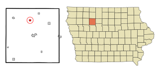
Paton is a city in Greene County, Iowa, United States. The population was 221 at the time of the 2020 census.

<span class="mw-page-title-main">Hillsboro, Iowa</span> City in Iowa, United States

Hillsboro is a city in Henry County, Iowa, United States. The population was 163 at the time of the 2020 census.

<span class="mw-page-title-main">Wyoming, Iowa</span> City in Iowa, United States

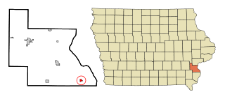
Wyoming is a city in Jones County, Iowa, United States. The population was 523 at the time of the 2020 census. It is part of the Cedar Rapids Metropolitan Statistical Area.

<span class="mw-page-title-main">Columbus City, Iowa</span> City in Iowa, United States

Columbus City is a city in western Louisa County, Iowa, United States. The population was 392 at the 2020 census. It is part of the Muscatine Micropolitan Statistical Area.

<span class="mw-page-title-main">Oakville, Iowa</span> City in Iowa, United States

Oakville is a city in southeasern Louisa County, Iowa, United States. The population was 200 at the time of the 2020 census. It is part of the Muscatine Micropolitan Statistical Area.

<span class="mw-page-title-main">Patterson, Iowa</span> City in Iowa, United States

Patterson is a city in Madison County, Iowa, United States. The population was 176 at the time of the 2020 census. It is part of the Des Moines–West Des Moines Metropolitan Statistical Area.

<span class="mw-page-title-main">Gilman, Iowa</span> City in Iowa, United States

Gilman is a city in the southeastern corner of Marshall County, Iowa, United States. The population was 542 at the time of the 2020 census.

<span class="mw-page-title-main">Havelock, Iowa</span> City in Iowa, United States

Havelock is a city in Pocahontas County, Iowa, United States. The population was 130 at the time of the 2020 census.

<span class="mw-page-title-main">Maloy, Iowa</span> City in Iowa, United States

Maloy is a city in southwest Ringgold County, Iowa, United States, along the Platte River. The population was 22 at the time of the 2020 census.

<span class="mw-page-title-main">Westphalia, Iowa</span> City in Iowa, United States

Westphalia is a city in Shelby County, Iowa, United States. The population was 126 at the time of the 2020 census.

<span class="mw-page-title-main">Spring Hill, Iowa</span> City in Iowa, United States

Spring Hill is a city in Warren County, Iowa, United States. The population was 68 at the time of the 2020 census. It is part of the Des Moines–West Des Moines Metropolitan Statistical Area.

<span class="mw-page-title-main">St. Marys, Iowa</span> City in Iowa, United States

St. Marys or Saint Marys is a city in Warren County, Iowa, United States. The population was 108 at the time of the 2020 census.

<span class="mw-page-title-main">Crawfordsville, Iowa</span> City in Iowa, United States

Crawfordsville is a city in Washington County, Iowa, United States. It is part of the Iowa City, Iowa Metropolitan Statistical Area. The population was 277 at the 2020 census.

<span class="mw-page-title-main">West Chester, Iowa</span> City in Iowa, United States

West Chester is a city in Washington County, Iowa, United States. It is part of the Iowa City, Iowa Metropolitan Statistical Area. The population was 144 at the time of the 2020 census.

<span class="mw-page-title-main">Kensett, Iowa</span> City in Iowa, United States

Kensett is a city in Worth County, Iowa, United States. The population was 257 at the time of the 2020 census. It is part of the Mason City Micropolitan Statistical Area.

References

  1. "2020 U.S. Gazetteer Files". United States Census Bureau. Retrieved March 16, 2022.
  2. 1 2 U.S. Geological Survey Geographic Names Information System: Cotter, Iowa
  3. 1 2 "2020 Census State Redistricting Data". census.gov. United states Census Bureau. Retrieved August 12, 2021.
  4. Springer, Arthur (1912). History of Louisa County, Iowa, from Its Earliest Settlement to 1912, Volume 1. S. J. Clarke Publishing Company. p. 304.
  5. Iowa Atlas & Gazetteer, DeLorme, 7th Edition, 2021 p. 51 ISBN   1946494003
  6. "US Gazetteer files 2010". United States Census Bureau. Archived from the original on July 2, 2012. Retrieved May 11, 2012.
  7. "Census of Population and Housing". Census.gov. Retrieved June 4, 2015.
  8. "U.S. Census website". United States Census Bureau . Retrieved May 11, 2012.
  9. "U.S. Census website". United States Census Bureau . Retrieved January 31, 2008.