Country Club Estates, Georgia

Last updated

Country Club Estates, Georgia
Glynn County Georgia Incorporated and Unincorporated areas Country Club Estates Highlighted.svg
Location in Glynn County and the state of Georgia
Coordinates: 31°12′41″N81°28′7″W / 31.21139°N 81.46861°W / 31.21139; -81.46861
Country United States
State Georgia
County Glynn
Area
[1]
  Total4.76 sq mi (12.33 km2)
  Land4.63 sq mi (11.99 km2)
  Water0.13 sq mi (0.34 km2)
Elevation
12 ft (4 m)
Population
 (2020)
  Total8,373
  Density1,808.42/sq mi (698.23/km2)
Time zone UTC-5 (Eastern (EST))
  Summer (DST) UTC-4 (EDT)
FIPS code 13-19830 [2]
GNIS feature ID1867238 [3]

Country Club Estates is an unincorporated community and census-designated place (CDP) in Glynn County, Georgia, United States. It is part of the Brunswick metropolitan statistical area. The population was 8,373 at the 2020 census, [4] down from 8,545 in 2010.

Contents

Geography

Country Club Estates is located at 31°12′41″N81°28′7″W / 31.21139°N 81.46861°W / 31.21139; -81.46861 (31.211438, -81.468663). [5] It is bordered to the south by the city of Brunswick and to the east by the Back River, an arm of the tidal Mackay River. U.S. Route 17 passes through the center of the CDP, leading south 5 miles (8 km) into downtown Brunswick and north 12 miles (19 km) to Darien. The CDP extends north as far as Chapel Crossing Road west of US 17 and Yacht Drive east of US 17.

According to the United States Census Bureau, the CDP has a total area of 4.7 square miles (12.3 km2), of which 4.6 square miles (12.0 km2) is land and 0.1 square miles (0.3 km2), or 2.23%, is water. [6]

Demographics

Historical population
CensusPop.Note
1990 5,192
2000 7,59446.3%
2010 8,54512.5%
2020 8,373−2.0%
U.S. Decennial Census [7]
1850-1870 [8] 1870-1880 [9]
1890-1910 [10] 1920-1930 [11]
1940 [12] 1950 [13] 1960 [14]
1970 [15] 1980 [16] 1990 [17]
2000 [18] 2010 [19] 2020 [4]

Country Club Estates was first listed as a CDP in the 1990 U.S. Census. [18]

Country Club Estates, Georgia – Racial and ethnic composition
Note: the US Census treats Hispanic/Latino as an ethnic category. This table excludes Latinos from the racial categories and assigns them to a separate category. Hispanics/Latinos may be of any race.
Race / Ethnicity (NH = Non-Hispanic)Pop 2000 [20] Pop 2010 [19] Pop 2020 [4] % 2000% 2010% 2020
White alone (NH)4,1713,5903,36754.92%42.01%40.21%
Black or African American alone (NH)2,9403,9343,63638.71%46.04%43.43%
Native American or Alaska Native alone (NH)2319200.30%0.22%0.24%
Asian alone (NH)831431421.09%1.67%1.70%
Pacific Islander alone (NH)1045420.13%0.53%0.50%
Some Other Race alone (NH)1020360.13%0.23%0.43%
Mixed race or Multiracial (NH)1031442821.36%1.69%3.37%
Hispanic or Latino (any race)2546508483.34%7.61%10.13%
Total7,5948,5458,373100.00%100.00%100.00%

As of the 2020 United States census, there were 8,373 people, 3,319 households, and 1,869 families residing in the CDP.

Education

The community's public schools are operated by the Glynn County School System. [21]

Zoned schools serving sections of the CDP include:

Related Research Articles

<span class="mw-page-title-main">Glynn County, Georgia</span> County in Georgia, United States

Glynn County is located in the southeastern part of the U.S. state of Georgia. As of the 2020 census, the population was 84,499. The county seat is Brunswick. Glynn County is part of the Brunswick, Georgia Metropolitan Statistical Area.

<span class="mw-page-title-main">Isle of Hope, Georgia</span> Place in Georgia, United States

Isle of Hope is an unincorporated community and census-designated place (CDP) in Chatham County, Georgia, United States. It is part of the Savannah Metropolitan Statistical Area, and at the 2020 U.S. census its population was 2,357. The island is one of the most affluent communities in the state and is well known for its historic plantations and exclusive waterfront properties.

<span class="mw-page-title-main">Vinings, Georgia</span> Place in Georgia, United States

Vinings is an unincorporated community and census-designated place (CDP) in Cobb County, Georgia, United States that runs along the Chattahoochee River bank across from Buckhead. As of the 2020 census, the CDP had a total population of 12,581. Located next to the affluent Paces section of Buckhead in northwest Atlanta, Vinings is known for its historic sites, shopping districts, proximity to local freeways and The Battery, and nearby nature areas. The United States Postal Service assigns "Atlanta" to the ZIP Code (30339) that includes Vinings.

<span class="mw-page-title-main">Belvedere Park, Georgia</span> Place in Georgia, United States

Belvedere Park is an unincorporated community and census-designated place (CDP) in DeKalb County, Georgia, United States. The population was 15,113 at the 2020 census.

<span class="mw-page-title-main">Candler-McAfee, Georgia</span> Place in Georgia, United States

Candler-McAfee is an unincorporated community and census-designated place (CDP) in DeKalb County, Georgia, United States. It is located east of Atlanta approximately 10 miles (16 km) east of Downtown Atlanta and to the south of Decatur, Georgia The population was 23,025 at the 2010 census.

<span class="mw-page-title-main">Druid Hills, Georgia</span> Neighborhood of Atlanta, Georgia, United States

Druid Hills is a community which includes both a census-designated place (CDP) in unincorporated DeKalb County, Georgia, United States, as well as a neighborhood of the city of Atlanta. The CDP's population was 14,568 at the 2010 census. The CDP formerly contained the main campus of Emory University and the Centers for Disease Control and Prevention (CDC); however, they were annexed by Atlanta in 2018. The Atlanta-city section of Druid Hills is one of Atlanta's most affluent neighborhoods with a mean household income in excess of $238,500.

<span class="mw-page-title-main">Gresham Park, Georgia</span> Place in Georgia, United States

Gresham Park is an unincorporated community and census-designated place (CDP) in DeKalb County, Georgia, United States. The population was 7,700 at the 2020 census.

<span class="mw-page-title-main">Dock Junction, Georgia</span> Place in Georgia, United States

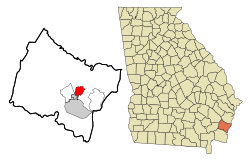
Dock Junction is an unincorporated community and census-designated place (CDP) in Glynn County, Georgia, United States. It is part of the Brunswick metropolitan statistical area. The population was 7,721 at the 2010 census, growing to 8,266 in 2020. Its original name was Arco until the 1970s, the name deriving from the Atlantic Refining Company.

<span class="mw-page-title-main">St. Simons, Georgia</span> Place in Georgia, United States

St. Simons Island is a barrier island and census-designated place (CDP) located on St. Simons Island in Glynn County, Georgia, United States. The names of the community and the island are interchangeable, known simply as "St. Simons Island" or "SSI", or locally as "The Island". St. Simons is part of the Brunswick metropolitan statistical area, and according to the 2020 U.S. census, the CDP had a population of 14,982. Located on the southeast Georgia coast, midway between Savannah and Jacksonville, St. Simons Island is both a seaside resort and residential community. It is the largest of Georgia's renowned Golden Isles. Visitors are drawn to the Island for its warm climate, beaches, variety of outdoor activities, shops and restaurants, historical sites, and natural environment.

<span class="mw-page-title-main">Lakeview Estates, Georgia</span> Place in Georgia, United States

Lakeview Estates, also known as Sunrise Lakes by local residents, is an unincorporated community and census-designated place (CDP) in Rockdale County, Georgia, United States. The population was 2,637 at the 2000 census.

<span class="mw-page-title-main">South Laurel, Maryland</span> Census-designated place in Maryland

South Laurel is an unincorporated area and census-designated place (CDP) in Prince George's County, Maryland, United States. Per the 2020 census, the population was 29,602.

<span class="mw-page-title-main">Woodmore, Maryland</span> Census-designated place in Maryland

Woodmore is an unincorporated area and census-designated place in Prince George's County, Maryland, United States. Per the 2020 census, the population was 4,513. The CDP is located within the boundaries of Route 193 to the west, Church Road to the east, Route 214 to the south and Route 50 to the north. Woodmore Road runs east and west through the center. It contains a large gated community and country club, developments of Woodmore Meadows, and Woodmore South on the south side, as well as various other custom built homes and farmland.

<span class="mw-page-title-main">Eulonia, Georgia</span> Place in Georgia, United States

Eulonia is an unincorporated community and census-designated place (CDP) in McIntosh County in the U.S. state of Georgia. Part of the Brunswick, Georgia Metropolitan Statistical Area, it is in the Low Country between Savannah and Brunswick near Interstate 95.

Waynesville is an unincorporated community and census-designated place (CDP) in Brantley County, Georgia, United States. It is part of the Brunswick, Georgia metropolitan statistical area. Its ZIP code is 31566. It was first listed as a CDP in the 2020 census with a population of 331.

Everett, Georgia is a small, rural unincorporated community and census-designated place (CDP) in Glynn County, Georgia, United States.

<span class="mw-page-title-main">Brunswick metropolitan area</span> Metropolitan Statistical Area in Georgia, United States

The Brunswick metropolitan area is the Coastal Georgian metropolitan statistical area centered on the principal city of Brunswick, Georgia. The U.S. Office of Management and Budget, Census Bureau and other entities define Brunswick's metropolitan statistical area as comprising Glynn, Brantley, and McIntosh counties, including the cities of Brunswick and Darien. According to the 2020 census, the metropolitan area had a population of 113,495.

<span class="mw-page-title-main">Brunswick High School (Georgia)</span> Public school in Brunswick, Georgia, United States

Brunswick High School is a public high school located in Brunswick in Glynn County, Georgia, United States. It is part of the Glynn County School District and opened in 1967. In January 2014, Brunswick High School opened a new facility on 3885 Altama Avenue, becoming one of the largest new schools in the state.

Calvary is a census-designated place and unincorporated community in Grady County, Georgia, United States. As of 2020, its population was 129. It is located along Georgia State Route 111, 15 miles (24 km) southwest of Cairo, the Grady County seat. Tallahassee, Florida, is 23 miles (37 km) to the south.

<span class="mw-page-title-main">Sterling, Georgia</span> Place in Georgia, United States

Sterling is an unincorporated community and census-designated place (CDP) in Glynn County, Georgia, United States, located on U.S. Route 341. Sterling consists of several small churches and general stores. It is included in the Brunswick, Georgia statistical area.

Big Thicket Lake Estates is a census-designated place (CDP) in Polk and Liberty counties, Texas, United States. This was a new CDP for the 2010 census, with a population of 742, decreasing to 514 at the 2020 census.

References

  1. "2020 U.S. Gazetteer Files". United States Census Bureau. Retrieved December 18, 2021.
  2. "U.S. Census website". United States Census Bureau . Retrieved January 31, 2008.
  3. "US Board on Geographic Names". United States Geological Survey. October 25, 2007. Retrieved January 31, 2008.
  4. 1 2 3 "P2: Hispanic or Latino, and Not Hispanic or Latino by Race – 2020: DEC Redistricting Data (PL 94-171) - Country Club Estates CDP, Georgia". United States Census Bureau.
  5. "US Gazetteer files: 2010, 2000, and 1990". United States Census Bureau. February 12, 2011. Retrieved April 23, 2011.
  6. "Geographic Identifiers: 2010 Demographic Profile Data (G001): Country Club Estates CDP, Georgia". American Factfinder. U.S. Census Bureau. Retrieved November 22, 2016.[ dead link ]
  7. "Decennial Census of Population and Housing by Decade". US Census Bureau.
  8. "1870 Census of Population - Georgia - Population of Civil Divisions less than Counties" (PDF). US Census Bureau . 1870.
  9. "1880 Census of Population - Georgia - Population of Civil Divisions less than Counties" (PDF). US Census Bureau . 1880.
  10. "1910 Census of Population - Georgia" (PDF). US Census Bureau . 1930.
  11. "1930 Census of Population - Georgia" (PDF). US Census Bureau . 1930. p. 251-256.
  12. "1940 Census of Population - Georgia" (PDF). US Census Bureau . 1940.
  13. "1950 Census of Population - Georgia" (PDF). US Census Bureau . 1980.
  14. "1960 Census of Population - Population of County Subdivisions - Georgia" (PDF). US Census Bureau . 1960.
  15. "1970 Census of Population - Population of County Subdivisions - Georgia" (PDF). US Census Bureau . 1970.
  16. "1980 Census of Population - Number of Inhabitants - Georgia" (PDF). US Census Bureau . 1980.
  17. "1990 Census of Population - Summary Social, Economic, and Housing Characteristics - Georgia" (PDF). US Census Bureau . 1990.
  18. 1 2 "2000 Census of Population - General Population Characteristics - Georgia" (PDF). US Census Bureau . 2000.
  19. 1 2 "P2: Hispanic or Latino, and Not Hispanic or Latino by Race – 2010: DEC Redistricting Data (PL 94-171) - Country Club Estates CDP, Georgia". United States Census Bureau.
  20. "P004 Hispanic or Latino, and Not Hispanic or Latino by Race – 2000: DEC Summary File 1 – Chattanooga Valley CDP, Georgia". United States Census Bureau.
  21. "2010 CENSUS - CENSUS BLOCK MAP: Country Club Estates CDP, GA." U.S. Census Bureau. Retrieved on March 13, 2019.
  22. "Elementary School Zones Map Archived March 12, 2019, at the Wayback Machine ." Glynn County School System. Retrieved on March 13, 2019.
  23. "Middle School Zones Map Archived 2019-03-12 at the Wayback Machine ." Glynn County School System. Retrieved on March 13, 2019. Detail maps: JMS [ permanent dead link ] and NMS Archived March 12, 2019, at the Wayback Machine .
  24. "High School Zones Map Archived March 12, 2019, at the Wayback Machine ." Glynn County School System. Retrieved on March 13, 2019.