Glynn County, Georgia

Last updated

Glynn County
Glynn County Courthouse, Brunswick, GA, US.jpg
Glynn County Courthouse
Map of Georgia highlighting Glynn County.svg
Location within the U.S. state of Georgia
Georgia in United States.svg
Georgia's location within the U.S.
Coordinates: 31°13′N81°29′W / 31.22°N 81.49°W / 31.22; -81.49
CountryFlag of the United States.svg United States
StateFlag of Georgia (U.S. state).svg  Georgia
Founded1777;247 years ago (1777)
Named for John Glynn
Seat Brunswick
Largest cityBrunswick
Government
  Chairman, Board of CommissionersDavid O'Quinn
Area
  Total585 sq mi (1,520 km2)
  Land420 sq mi (1,100 km2)
  Water165 sq mi (430 km2)  28.3%
Population
 (2020)
  Total84,499
  Density201/sq mi (78/km2)
Time zone UTC−5 (Eastern)
  Summer (DST) UTC−4 (EDT)
Congressional district 1st
Website www.glynncounty.org

Glynn County is located in the southeastern part of the U.S. state of Georgia. As of the 2020 census, the population was 84,499. [1] The county seat is Brunswick. [2] Glynn County is part of the Brunswick, Georgia Metropolitan Statistical Area.

Contents

History

Glynn County, one of the state's original eight counties created on February 5, 1777, was named after John Glynn, [3] a member of the British House of Commons who defended the cause of the American Colonies before the American Revolution. The Battle of Bloody Marsh was fought in Glynn County. James Oglethorpe built Fort Frederica, which was used a base in the American Revolutionary War. Glynn Academy, established to educate boys, is the second oldest school in Georgia.

Glynn County includes the most prominent of the Sea Islands of Georgia, including Jekyll Island, St. Simons Island, and Sea Island. The Georgia poet Sidney Lanier immortalized the seacoast there in his poem, "The Marshes of Glynn", which begins:

Glooms of the live-oaks, beautiful-braided and woven
With intricate shades of the vines that myriad-cloven
Clamber the forks of the multiform boughs,--
Emerald twilights,--
Virginal shy lights,
Wrought of the leaves to allure to the whisper of vows,
When lovers pace timidly down through the green colonnades
Of the dim sweet woods, of the dear dark woods,
Of the heavenly woods and glades,
That run to the radiant marginal sand-beach within
The wide sea-marshes of Glynn;--

During World War II, Naval Air Station Glynco, named for the county, was a major base for training for blimps and anti-submarine warfare. The Federal Law Enforcement Training Center (FLETC) now uses a substantial part of the former NAS as its main campus.

Geography

Old Glynn County Courthouse Old Glynn County Courthouse, Brunswick, GA, USA.jpg
Old Glynn County Courthouse
Historical marker Glynn County, Georgia historical marker.JPG
Historical marker

According to the U.S. Census Bureau, the county has a total area of 585 square miles (1,520 km2), of which 420 square miles (1,100 km2) is land and 165 square miles (430 km2) (28.3%) is water. [4]

The majority of Glynn County is located in the Cumberland-St. Simons sub-basin of the St. Marys- Satilla River basin. Most of the county's northern and northwestern border area is located in the Altamaha River sub-basin of the basin by the same name. [5]

Major highways

Adjacent counties

Communities

City

Census-designated places

Unincorporated community

Ghost towns

Demographics

Historical population
CensusPop.Note
1790 413
1800 1,874353.8%
1810 3,41782.3%
1820 3,4180.0%
1830 4,56733.6%
1840 5,30216.1%
1850 4,933−7.0%
1860 3,889−21.2%
1870 5,37638.2%
1880 6,49720.9%
1890 13,420106.6%
1900 14,3176.7%
1910 15,7209.8%
1920 19,37023.2%
1930 19,4000.2%
1940 21,92013.0%
1950 29,04632.5%
1960 41,95444.4%
1970 50,52820.4%
1980 54,9818.8%
1990 62,49613.7%
2000 67,5688.1%
2010 79,62617.8%
2020 84,4996.1%
2023 (est.)86,172 [7] 2.0%
U.S. Decennial Census [8]
1790-1880 [9] 1890-1910 [10]
1920-1930 [11] 1930-1940 [12]
1940-1950 [13] 1960-1980 [14]
1980-2000 [15] 2010 [16]
Glynn County racial composition as of 2020 [17]
RaceNum.Perc.
White (non-Hispanic)52,98762.71%
Black or African American (non-Hispanic)20,46924.22%
Native American 1750.21%
Asian 1,1751.39%
Pacific Islander 920.11%
Other/Mixed 3,2653.86%
Hispanic or Latino 6,3367.5%

As of the 2020 United States census, there were 84,499 people, 34,614 households, and 22,352 families residing in the county.

2015

In terms of European ancestry, 40.8% were English, 10.6% were "American", 10.2% were Irish, and 7.9% were German. [18]

Education

Glynn County's public schools are operated by Glynn County School System.

Superfund sites

Glynn County is home to four Superfund sites. Those include the "LCP Chemicals Georgia" site, [19] the "Brunswick Wood Preserving" site, [20] the "Hercules 009 Landfill" site, [21] and the "Terry Creek Dredge Spoil Areas/Hercules Outfall" site. [22]

The Hanlin Group, Inc., which maintained a facility named "LCP Chemicals" in Glynn County just outside the corporate limits of Brunswick, was convicted of dumping 150 tons of mercury into Purvis Creek, a tributary of the Turtle River and surrounding tidal marshes between the mid-1980s and its closure in 1994. Three executives were sentenced to prison time over the incident. [23]

The LCP facility had been declared a Superfund site when it closed in 1994. It had been under scrutiny by the EPA after Service biologists discovered mercury poisoning in endangered wood storks on St. Simons Island. Fish, shellfish, crabs, and shrimps taken in coastal waters, as well as other bird species, also contained the toxic metal. The Service traced the source of the contamination to the LCP plant and documented the extent of the damage to wildlife resources. Their effort resulted in the addition of Endangered Species Act charges to those that would be brought against Hanlin and its officers. [24]

Crime

In 2020, the FBI ranked the Brunswick metropolitan area (which includes the counties of Glynn, Brantley and McIntosh) as the 7th most dangerous metropolitan area in the state of Georgia. [25]

On August 29, 2009, Glynn County resident Guy Heinze Jr. murdered eight members of his extended family including his father, Guy Heinze Sr. in the family's trailer located in New Hope Plantation Mobile Home Park near Brunswick. Two others were critically injured, with one dying later in a hospital in Savannah. Heinze Jr. avoided the death penalty and was sentenced to life in prison without parole on October 30, 2013. [26]

Politics

Similar to Southeast Georgia, Glynn County is heavily Republican, having last voted Democratic in 1980, when the Democratic nominee was Jimmy Carter.

United States presidential election results for Glynn County, Georgia [27]
Year Republican Democratic Third party
No.%No.%No.%
2020 25,61761.00%15,88237.82%4951.18%
2016 21,51262.47%11,77534.19%1,1503.34%
2012 20,89362.95%11,95036.00%3481.05%
2008 20,47961.31%12,67637.95%2480.74%
2004 18,60867.08%8,96232.31%1690.61%
2000 14,34664.09%7,77834.75%2601.16%
1996 12,30556.96%8,05837.30%1,2395.74%
1992 11,24249.02%8,58137.42%3,10913.56%
1988 11,12663.18%6,33935.99%1460.83%
1984 11,72464.07%6,57435.93%00.00%
1980 7,21447.54%7,54049.69%4192.76%
1976 5,40336.35%9,45963.65%00.00%
1972 9,44375.88%3,00224.12%00.00%
1968 3,72530.24%3,25126.39%5,34143.36%
1964 7,34156.22%5,71243.75%40.03%
1960 2,92644.95%3,58455.05%00.00%
1956 3,09850.22%3,07149.78%00.00%
1952 2,57543.47%3,34856.53%00.00%
1948 1,09023.80%2,44453.36%1,04622.84%
1944 38516.18%1,99583.82%00.00%
1940 27411.94%2,01487.76%70.31%
1936 26011.88%1,92587.98%30.14%
1932 18612.81%1,26286.91%40.28%
1928 79959.27%54940.73%00.00%
1924 28329.18%61263.09%757.73%
1920 13223.83%42276.17%00.00%
1916 366.45%47785.48%458.06%
1912 163.21%47094.19%132.61%

See also

Related Research Articles

<span class="mw-page-title-main">Wayne County, Georgia</span> County in Georgia, United States

Wayne County is a county located in the southeastern part of the U.S. state of Georgia. As of the 2020 census, the population was 30,144. The county seat is Jesup.

<span class="mw-page-title-main">Treutlen County, Georgia</span> County in Georgia, United States

Treutlen County is a county located in the east central. & Magnolia midlands portion of the U.S. state of Georgia. As of the 2020 census, the population was 6,406. The county seat is Soperton. It is host to the Million Pines Arts and Crafts Festival which occurs during the first weekend in November.

<span class="mw-page-title-main">Tattnall County, Georgia</span> County in Georgia, United States

Tattnall County is a county located in the southeast portion of the U.S. state of Georgia, located within the Magnolia Midlands, a part of the Historic South region. As of the 2020 census, the population was 22,842. The county seat is Reidsville. Tattnall County was created on December 5, 1801, from part of Montgomery County, Georgia by the Georgia General Assembly.

<span class="mw-page-title-main">Peach County, Georgia</span> County in Georgia, United States

Peach County is a county located in the central portion of the U.S. state of Georgia. As of the 2020 census, the population was 27,981. Its county seat is Fort Valley. Founded in 1924, it is the state's newest county, taken from Houston and Macon counties on July 18 of that year. Its namesake is the peach on account of it being located in a peach-growing district.

<span class="mw-page-title-main">McIntosh County, Georgia</span> County in Georgia, United States

McIntosh County is a county located in the U.S. state of Georgia. As of the 2020 census, the population was 10,975, a drop of 23.4 percent since the 2010 census. The county seat is Darien.

<span class="mw-page-title-main">Laurens County, Georgia</span> County in Georgia, United States

Laurens County is a county located in the central part of the U.S. state of Georgia. As of the 2020 census, the population was 49,570, up from 48,434 in 2010. The county seat is Dublin. The county was founded on December 10, 1807, and named after Lieutenant Colonel John Laurens, an American soldier and statesman from South Carolina during the American Revolutionary War.

<span class="mw-page-title-main">Johnson County, Georgia</span> County in Georgia, United States

Johnson County is a county located along the oconee River in the U.S. state of Georgia. As of the 2020 census, the population was 9,189. The county seat is Wrightsville. Johnson County is part of the Dublin, Georgia, micropolitan statistical area.

<span class="mw-page-title-main">Jeff Davis County, Georgia</span> County in Georgia, United States

Jeff Davis County is a county located in the southeastern part of the U.S. state of Georgia. As of the 2020 census, the population was 14,779. The county seat is Hazlehurst. The county was created on August 18, 1905, and named for Jefferson Davis, the only Confederate president.

<span class="mw-page-title-main">Dodge County, Georgia</span> County in Georgia, United States

Dodge County is a county located in the central portion of the U.S. state of Georgia. As of 2020, the population was 19,925. The county seat is Eastman. Dodge County lies in the Historic South and Black Belt region of Georgia, an area that was devoted to cotton production in the antebellum years. It has significant historic buildings and plantations, has a substantial African-American population, and shows cultural aspects of the South.

<span class="mw-page-title-main">Camden County, Georgia</span> County in Georgia, United States

Camden County is a county located in the southeastern corner of the U.S. state of Georgia. According to the 2020 census, its population was 54,768. Its county seat is Woodbine, and the largest city is Kingsland. It is one of the original counties of Georgia, created February 5, 1777. It is the 11th-largest county in the state of Georgia by area, and the 41st-largest by population.

<span class="mw-page-title-main">Brantley County, Georgia</span> County in Georgia, United States

Brantley County is a county located in the southeastern part of the U.S. state of Georgia. As of the 2020 census, the population was 18,021. The county seat is Nahunta. Brantley County is part of the Brunswick, Georgia metropolitan statistical area.

<span class="mw-page-title-main">Bleckley County, Georgia</span> County in Georgia, United States

Bleckley County is a county located in the central portion of the U.S. state of Georgia. As of the 2020 census, the population was 12,583. The county seat is Cochran.

<span class="mw-page-title-main">Brunswick, Georgia</span> City in Glynn County, Georgia, US

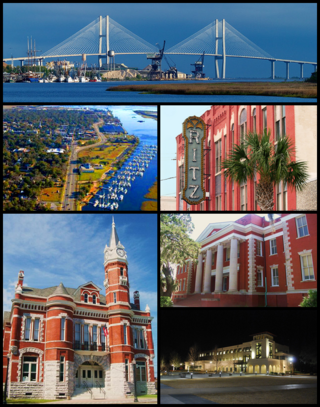
Brunswick is a city in and the county seat of Glynn County in the U.S. state of Georgia. As the primary urban and economic center of the lower southeast portion of Georgia, it is the second-largest urban area on the Georgia coastline after Savannah and contains the Brunswick Old Town Historic District. At the 2020 U.S. census, the population of the city proper was 15,210; the Brunswick metropolitan area's population as of 2020 was 113,495.

<span class="mw-page-title-main">Country Club Estates, Georgia</span> Place in Georgia, United States

Country Club Estates is an unincorporated community and census-designated place (CDP) in Glynn County, Georgia, United States. It is part of the Brunswick metropolitan statistical area. The population was 8,373 at the 2020 census, down from 8,545 in 2010.

<span class="mw-page-title-main">Dock Junction, Georgia</span> Place in Georgia, United States

Dock Junction is an unincorporated community and census-designated place (CDP) in Glynn County, Georgia, United States. It is part of the Brunswick metropolitan statistical area. The population was 7,721 at the 2010 census, growing to 8,266 in 2020. Its original name was Arco until the 1970s, the name deriving from the Atlantic Refining Company.

<span class="mw-page-title-main">St. Simons, Georgia</span> Place in Georgia, United States

St. Simons Island is a barrier island and census-designated place (CDP) located on St. Simons Island in Glynn County, Georgia, United States. The names of the community and the island are interchangeable, known simply as "St. Simons Island" or "SSI", or locally as "The Island". St. Simons is part of the Brunswick metropolitan statistical area, and according to the 2020 U.S. census, the CDP had a population of 14,982. Located on the southeast Georgia coast, midway between Savannah and Jacksonville, St. Simons Island is both a seaside resort and residential community. It is the largest of Georgia's renowned Golden Isles. Visitors are drawn to the Island for its warm climate, beaches, variety of outdoor activities, shops and restaurants, historical sites, and natural environment.

<span class="mw-page-title-main">Lower Coastal Plain (Georgia)</span> Subregion

Southeast Georgia's Lower Coastal Plain, often referred to as the "Coastal Empire", is a subregion that encompasses the lowest-lying areas of the Atlantic coastal plain in the state, containing barrier islands, marshes, and swampy lowlands, as well as flat plains and low terraces. It differs from Georgia's Upper Coastal Plain in that it is lower in elevation with less relief and wetter soils. The United States Environmental Protection Agency defines the Lower Coastal Plain as an ecoregion, part of the larger, interstate Southern Coastal Plain.

<span class="mw-page-title-main">Golden Isles of Georgia</span> Place in Georgia, United States

The Golden Isles of Georgia consist of barrier islands, and the mainland port cities of Brunswick and Darien, on the 100-mile-long coast of the U.S. state of Georgia on the Atlantic Ocean. They include St. Simons Island, Sea Island, Jekyll Island, Little St. Simons Island, Sapelo Island, Blackbeard Island, Historic Darien and Historic Brunswick. The islands are part of a long chain of barrier islands known as the "Sea Islands", located along the coasts of South Carolina, Georgia and northern Florida.

<span class="mw-page-title-main">History of Brunswick, Georgia</span>

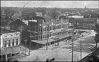
The recorded History of Brunswick, Georgia dates to 1738, when a 1,000-acre (4 km2) plantation was established along the Turtle River. By 1789, the city was recognized by President George Washington as having been one of five original ports of entry for the American colonies. In 1797, Brunswick's prominence was further recognized when it became the county seat of Glynn County, a status it retains to this day. During the later stages of the Civil War, with the approach of the Union Army, much of the city was abandoned and burned. Economic prosperity eventually returned, when a large lumber mill was constructed in the area. By the late 19th-century, despite yellow fever epidemics and occasional hurricanes, business in Brunswick was thriving, due to port business for cotton, lumber, naval stores, and oysters. During this period, Brunswick also enjoyed a tourist trade, stimulated by nearby Jekyll Island, which had become a posh, exclusive getaway for some of the era's most influential people. World War I stimulated ship building activity in Brunswick. But it was not until World War II that the economy boomed, when 16,000 workers were employed to produce ninety-nine Liberty ships and "Knot" ships. During the war, Brunswick's Glynco Naval Air Station was, for a time, the largest blimp base in the world. Since the end of World War II, the city has enjoyed a period of moderate economic activity, centered on its deep natural port, which is the westernmost harbor on the eastern seaboard. In recent years, in recognition of a thriving local enterprise, Brunswick has declared itself to be the "Shrimp Capital of the World".

<span class="mw-page-title-main">Glynn County School District</span> School district in Georgia (U.S. state)

The Glynn County School District is a public school district in Glynn County, Georgia, United States, based in Brunswick. It serves the communities of Brunswick, Country Club Estates, Dock Junction, Everett, St. Simons Island, and Sterling.

References

  1. "Census - Geography Profile: Glynn County, Georgia". United States Census Bureau . Retrieved December 27, 2022.
  2. "Find a County". National Association of Counties. Archived from the original on May 31, 2011. Retrieved June 7, 2011.
  3. Gannett, Henry (1905). The Origin of Certain Place Names in the United States. Govt. Print. Off. pp.  139.
  4. "US Gazetteer files: 2010, 2000, and 1990". United States Census Bureau. February 12, 2011. Retrieved April 23, 2011.
  5. "Georgia Soil and Water Conservation Commission Interactive Mapping Experience". Georgia Soil and Water Conservation Commission. Archived from the original on October 3, 2018. Retrieved November 27, 2015.
  6. Thalmann, Georgia Amtrak Station (USA Rail Guide Train Web)
  7. "Annual Estimates of the Resident Population for Counties: April 1, 2020 to July 1, 2023". United States Census Bureau. Retrieved March 31, 2024.
  8. "Decennial Census of Population and Housing by Decades". United States Census Bureau.
  9. "1880 Census Population by Counties 1790-1800" (PDF). United States Census Bureau. 1880.
  10. "1910 Census of Population - Georgia" (PDF). United States Census Bureau. 1910.
  11. "1930 Census of Population - Georgia" (PDF). United States Census Bureau. 1930.
  12. "1940 Census of Population - Georgia" (PDF). United States Census Bureau. 1940.
  13. "1950 Census of Population - Georgia -" (PDF). United States Census Bureau. 1950.
  14. "1980 Census of Population - Number of Inhabitants - Georgia" (PDF). United States Census Bureau. 1980.
  15. "2000 Census of Population - Population and Housing Unit Counts - Georgia" (PDF). United States Census Bureau. 2000.
  16. "State & County QuickFacts". United States Census Bureau. Archived from the original on July 3, 2011. Retrieved June 22, 2014.
  17. "Explore Census Data". data.census.gov. Retrieved December 18, 2021.
  18. "DP03 SELECTED ECONOMIC CHARACTERISTICS – 2006-2010 American Community Survey 5-Year Estimates". United States Census Bureau. Archived from the original on February 13, 2020. Retrieved December 29, 2015.
  19. "LCP Chemicals Georgia". EPA. Retrieved May 31, 2017.
  20. "Brunswick Wood Preserving". EPA. Retrieved May 31, 2017.
  21. "Hercules 009 Landfill". EPA. Retrieved May 31, 2017.
  22. "Terry Creek Dredge Spoil Areas/Hercules Outfall". EPA. Retrieved May 31, 2017.
  23. "Former LCP Official Gets Jail Time, Fine". Savannah Morning News. Retrieved May 31, 2017.
  24. "LCP Chemicals Georgia - Site Details". EPA. Retrieved May 31, 2017.
  25. Lashway, Zachery. "FBI ranks Brunswick 7th most dangerous metro area in Georgia". News 4 Jax. Graham Media Group. Retrieved February 17, 2022.
  26. Bynum, Russ. "Georgia man gets life sentence in beating deaths of 8". OnlineAthens. Athens Banner-Herald. Retrieved February 17, 2022.
  27. Leip, David. "Dave Leip's Atlas of U.S. Presidential Elections". uselectionatlas.org. Retrieved March 20, 2018.

31°13′N81°29′W / 31.22°N 81.49°W / 31.22; -81.49