Barrow County | |
---|---|
Coordinates: 33°59′N83°43′W / 33.99°N 83.71°W | |
Country | United States |
State | Georgia |
Founded | July 7, 1914 |
Named for | David Crenshaw Barrow Jr. |
Seat | Winder |
Largest city | Winder |
Area | |
• Total | 163 sq mi (420 km2) |
• Land | 160 sq mi (400 km2) |
• Water | 2.6 sq mi (7 km2) 1.6% |
Population (2020) | |
• Total | 85,588 |
• Density | 534.93/sq mi (110/km2) |
Time zone | UTC−5 (Eastern) |
• Summer (DST) | UTC−4 (EDT) |
Congressional district | 10th |
Website | www |
Barrow County is a county located in the north central portion of the U.S. state of Georgia. As of the 2020 census, the population was 83,505. [1] The county seat is Winder. [2] Barrow County is included in the Atlanta-Sandy Springs-Roswell metropolitan statistical area.
Barrow County was created from portions of Gwinnett, Jackson, and Walton counties when Georgia voters approved a constitutional amendment on November 3, 1914, making Barrow County the 149th Georgia county out of 159. Barrow County was named after David Crenshaw Barrow, Jr., a University of Georgia mathematics and engineering professor who was later Chancellor serving in that position from 1906 to 1925. Barrow died on January 11, 1929, in Athens and is buried in Oconee Hill Cemetery in Athens. [3]
According to the U.S. Census Bureau, the county has a total area of 163 square miles (420 km2), of which 160 square miles (410 km2) is land and 2.6 square miles (6.7 km2) (1.6%) is water. [4] The entirety of Barrow County is located in the Upper Oconee River sub-basin of the Altamaha River basin. [5]
Census | Pop. | Note | %± |
---|---|---|---|
1920 | 13,188 | — | |
1930 | 12,401 | −6.0% | |
1940 | 13,064 | 5.3% | |
1950 | 13,115 | 0.4% | |
1960 | 14,485 | 10.4% | |
1970 | 16,859 | 16.4% | |
1980 | 21,354 | 26.7% | |
1990 | 29,721 | 39.2% | |
2000 | 46,144 | 55.3% | |
2010 | 69,367 | 50.3% | |
2020 | 83,505 | 20.4% | |
2023 (est.) | 92,792 | [6] | 11.1% |
U.S. Decennial Census [7] 1790-1880 [8] 1890-1910 [9] 1920-1930 [10] 1930-1940 [11] 1940-1950 [12] 1960-1980 [13] 1980-2000 [14] 2010 [15] 2020 [16] |
Race / Ethnicity | Pop 2000 [17] | Pop 2010 [15] | Pop 2020 [16] | % 2000 | % 2010 | % 2020 |
---|---|---|---|---|---|---|
White alone (NH) | 38,543 | 51,736 | 55,582 | 83.53% | 74.58% | 66.56% |
Black or African American alone (NH) | 4,456 | 7,769 | 10,141 | 9.66% | 11.20% | 12.14% |
Native American or Alaska Native alone (NH) | 119 | 130 | 130 | 0.26% | 0.19% | 0.16% |
Asian alone (NH) | 1,000 | 2,359 | 3,233 | 2.17% | 3.40% | 3.87% |
Pacific Islander alone (NH) | 15 | 28 | 17 | 0.03% | 0.04% | 0.02% |
Other race alone (NH) | 27 | 141 | 459 | 0.06% | 0.20% | 0.55% |
Mixed race or Multiracial (NH) | 524 | 1,167 | 3,383 | 1.14% | 1.68% | 4.05% |
Hispanic or Latino (any race) | 1,460 | 6,037 | 10,560 | 3.16% | 8.70% | 12.65% |
Total | 46,144 | 69,367 | 83,505 | 100.00% | 100.00% | 100.00% |
At the 2020 United States census, there were 83,505 people, [18] 27,765 households, and 20,948 families residing in the county. In 2010, there here were 69,367 people, 23,971 households, and 18,214 families living in the county. [19] The population density was 432.7 inhabitants per square mile (167.1/km2). There were 26,400 housing units at an average density of 164.7 per square mile (63.6/km2). [20]
In 2000, the racial makeup of the county was 84.84% White, 10.72% Black or African American, 0.30% Native American, 2.20% Asian, 0.04% Pacific Islander, 1.50% from other races, and 1.40% from two or more races. 3.16% of the population were Hispanic or Latino of any race. Barrow County is considered a part of the Atlanta, GA combined statistical area despite its comparatively small population. In 2010, the racial and ethnic makeup of the county was 78.8% White, 11.4% Black or African American, 3.4% Asian, 0.3% American Indian, 0.1% Pacific islander, 3.7% from other races, and 2.3% from two or more races. Those of Hispanic or Latino origin made up 8.7% of the population. [19] In terms of ancestry, 20.6% were American, 10.7% were Irish, 9.1% were German, and 8.5% were English. [21]
In 2010, the median income for a household in the county was $48,958 and the median income for a family was $55,415. Males had a median income of $42,869 versus $33,175 for females. The per capita income for the county was $20,882. About 9.4% of families and 12.6% of the population were below the poverty line, including 16.0% of those under age 18 and 14.2% of those age 65 or over. [22]
Winder-Barrow Cluster:
Apalachee Cluster:
Year | Republican | Democratic | Third party | |||
---|---|---|---|---|---|---|
No. | % | No. | % | No. | % | |
2020 | 26,804 | 70.64% | 10,453 | 27.55% | 689 | 1.82% |
2016 | 21,108 | 72.35% | 6,580 | 22.55% | 1,486 | 5.09% |
2012 | 18,725 | 74.10% | 6,028 | 23.85% | 517 | 2.05% |
2008 | 17,625 | 71.55% | 6,657 | 27.02% | 351 | 1.42% |
2004 | 13,520 | 76.17% | 4,095 | 23.07% | 135 | 0.76% |
2000 | 7,925 | 65.49% | 3,657 | 30.22% | 520 | 4.30% |
1996 | 5,342 | 51.65% | 3,928 | 37.98% | 1,072 | 10.37% |
1992 | 4,328 | 43.36% | 3,991 | 39.98% | 1,663 | 16.66% |
1988 | 4,738 | 65.64% | 2,442 | 33.83% | 38 | 0.53% |
1984 | 4,123 | 63.53% | 2,367 | 36.47% | 0 | 0.00% |
1980 | 2,284 | 36.20% | 3,876 | 61.44% | 149 | 2.36% |
1976 | 1,364 | 22.29% | 4,756 | 77.71% | 0 | 0.00% |
1972 | 3,423 | 79.79% | 867 | 20.21% | 0 | 0.00% |
1968 | 1,372 | 26.52% | 1,070 | 20.68% | 2,731 | 52.79% |
1964 | 2,316 | 50.42% | 2,277 | 49.58% | 0 | 0.00% |
1960 | 577 | 17.30% | 2,759 | 82.70% | 0 | 0.00% |
1956 | 442 | 16.32% | 2,266 | 83.68% | 0 | 0.00% |
1952 | 236 | 9.07% | 2,367 | 90.93% | 0 | 0.00% |
1948 | 155 | 7.55% | 1,554 | 75.69% | 344 | 16.76% |
1944 | 257 | 14.52% | 1,513 | 85.48% | 0 | 0.00% |
1940 | 219 | 11.91% | 1,615 | 87.82% | 5 | 0.27% |
1936 | 172 | 12.69% | 1,181 | 87.16% | 2 | 0.15% |
1932 | 23 | 2.01% | 1,111 | 97.03% | 11 | 0.96% |
1928 | 684 | 58.81% | 479 | 41.19% | 0 | 0.00% |
1924 | 88 | 11.55% | 501 | 65.75% | 173 | 22.70% |
1920 | 412 | 36.05% | 731 | 63.95% | 0 | 0.00% |
1916 | 102 | 10.60% | 712 | 74.01% | 148 | 15.38% |
Clay County is a county located in the southwestern part of the U.S. state of Georgia. As of the 2020 census, the population was 2,848, making it the fourth-least populous county in Georgia. The county seat is Fort Gaines.
Franklin County is a county located in the U.S. state of Alabama. As of the 2020 census, the population was 32,113. Its county seat is Russellville. Its name is in honor of Benjamin Franklin, famous statesman, scientist, and printer. It is a dry county, although the city of Russellville is wet.
Whitfield County is a county located in the northwestern part of the U.S. state of Georgia. As of the 2020 census shows a population of 102,864. The county seat is Dalton. The county was created on December 30, 1851, and named after George Whitefield, Methodist evangelist. The "e" was omitted to reflect the pronunciation of his name.
Washington County is a county located in the U.S. state of Georgia. As of the 2020 census, the population was 19,988. The county seat is Sandersville. The county was established on February 25, 1784. It was named for Revolutionary War general George Washington.
Walton County is a county located in the Middle Georgia portion of the U.S. - State of Georgia. As of the 2020 census, the population was 96,673. It is located about 30 miles east of the state capital, the city of Atlanta. Monroe is the county seat; Loganville is another major city.
Paulding County is a county located in the northwestern part of the U.S. state of Georgia. Part of the Atlanta metropolitan area, it had an estimated population of 168,661 in 2020. The county seat is Dallas.
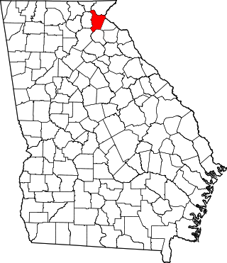
Morgan County is a county located in the north central Piedmont region and the lake country region of the U.S. state of Georgia. As of the 2020 census, the population was 20,097. The county seat is Madison.
Laurens County is a county located in the central part of the U.S. state of Georgia. As of the 2020 census, the population was 49,570, up from 48,434 in 2010. The county seat is Dublin. The county was founded on December 10, 1807, and named after Lieutenant Colonel John Laurens, an American soldier and statesman from South Carolina during the American Revolutionary War.
Johnson County is a county located along the oconee River in the U.S. state of Georgia. As of the 2020 census, the population was 9,189. The county seat is Wrightsville. Johnson County is part of the Dublin, Georgia, micropolitan statistical area.
Hart County is a county located in the northeastern part of the U.S. state of Georgia. As of the 2020 census, the population was 25,828. The county seat is Hartwell.
Habersham County is a county located in the northeastern part of the U.S. state of Georgia. As of the 2020 census, the population was 46,031. The county seat is Clarkesville. The county was created on December 15, 1818, and named for Colonel Joseph Habersham of the Continental Army in the Revolutionary War.
Franklin County is a county located in the northeastern part of the U.S. state of Georgia. As of the 2020 census, the population was 23,424. The county seat is Carnesville. On February 25, 1784, Franklin and Washington became Georgia's eighth and ninth counties, with Franklin named in honor of patriot Benjamin Franklin.
Clayton County is located in the north central portion of the U.S. state of Georgia. As of 2021, the population was estimated to be 297,100 by the Census Bureau. The county seat is Jonesboro.
Clarke County is located in the northeastern part of the U.S. state of Georgia. As of the 2020 census, the population was 128,671. Its county seat is Athens, with which it is a consolidated city-county. Clarke County is included in the Athens-Clarke County, GA Metropolitan Statistical Area, which is also included in the Atlanta-Athens-Clarke County-Sandy Springs, GA Combined Statistical Area.
Chattooga County is a county located in the northwestern part of the U.S. state of Georgia. As of the 2020 census, the population was 24,965. The county seat is Summerville. The county was created on December 28, 1838.
Catoosa County is a county located in the northwestern part of the U.S. state of Georgia. As of the 2020 census, the population was 67,872. The county seat is Ringgold. The county was created on December 5, 1853. The meaning of the Cherokee language name "Catoosa" is obscure: "Catoosa" may come from the Cherokee words gatusi or gatu'gitse.
Winder is a city and the county seat of Barrow County, Georgia, United States. It is located east of Atlanta and is part of the Atlanta metropolitan area. The population was 18,338 at the 2020 census.
Hoschton is a city in Barrow County, Georgia, United States. The population was 1,377 at the 2010 census. As of 2018 the estimated population was 1,916.
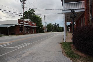
Bostwick is a city in Morgan County, Georgia, United States. As of the 2020 census, the city had a population of 378.
Rutledge is a city in Morgan County, Georgia, United States. Founded in 1871, the city had a population of 871 at the 2020 census, up from 781 in 2010.