Woodstock, Georgia

Last updated

Woodstock, Georgia
DJI 0038ee.jpg
Downtown Woodstock
Flag of Woodstock, Georgia.png
Seal of Woodstock, Georgia.png
Cherokee County Georgia Incorporated and Unincorporated areas Woodstock Highlighted.svg
Location in Cherokee County and the state of Georgia
USA Georgia location map.svg
Red pog.svg
Woodstock, Georgia
Usa edcp location map.svg
Red pog.svg
Woodstock, Georgia
Metro atlanta.jpg
Red pog.svg
Woodstock, Georgia
Coordinates: 34°06′05″N84°31′10″W / 34.10139°N 84.51944°W / 34.10139; -84.51944
CountryUnited States
State Georgia
County Cherokee
Government
   Mayor Michael Caldwell (R)
Area
[1]
  Total12.67 sq mi (32.81 km2)
  Land12.56 sq mi (32.53 km2)
  Water0.11 sq mi (0.28 km2)
Elevation
968 ft (291 m)
Population
 (2020)
  Total35,065
  Density2,792.02/sq mi (1,078.04/km2)
Time zone UTC−5 (EST)
  Summer (DST) UTC−4 (EDT)
ZIP codes
30188-30189
Area code 770/678/470
FIPS code 13-84176 [2]
GNIS feature ID0333462 [3]
Website www.woodstockga.gov

Woodstock is a city in Cherokee County, Georgia, United States. The population was 35,065 as of 2020 according to the US Census Bureau. [4]

Contents

Originally a stop on the Louisville and Nashville Railroad, Woodstock is part of the Atlanta metropolitan area. The city was the tenth fastest-growing suburb in the United States in 2007. [5] Woodstock is the 28th most-populous city in Georgia and ranked 16th for population density out of 538 municipalities. [4]

History

Native Americans were removed from the area. [6]

The Georgia General Assembly incorporated Woodstock as a town in 1897. [7] The community derives its name from Woodstock, an 1826 novel by Walter Scott. [8]

The Woodstock Depot was built in 1912 by the Louisville & Nashville Railroad as the town grew. The line transported cotton, rope, and other agricultural products, as well as passengers. Passenger service ended in 1949. [9]

Geography

According to the United States Census Bureau, Woodstock has a total area of 11.3 square miles (29.2 km2), of which 11.2 square miles (28.9 km2) is land and 0.12 square miles (0.3 km2), or 0.92%, is water. [10]

Demographics

Historical population
CensusPop.Note
1880 92
1900 276
1910 44260.1%
1920 415−6.1%
1930 4211.4%
1940 389−7.6%
1950 54540.1%
1960 72633.2%
1970 87019.8%
1980 2,699210.2%
1990 4,36161.6%
2000 10,050130.5%
2010 23,896137.8%
2020 35,06546.7%
U.S. Decennial Census [11]
Fall in Kings Ridge Estate, Woodstock Fall in Kings Ridge Estates in Woodstock GA.jpg
Fall in Kings Ridge Estate, Woodstock
Highway 92 in Woodstock Woodstock GA.JPG
Highway 92 in Woodstock

2020 census

Woodstock racial composition [12]
RaceNum.Perc.
White (non-Hispanic)23,72767.67%
Black or African American (non-Hispanic)3,85611.0%
Native American 350.1%
Asian 1,5294.36%
Pacific Islander 200.06%
Other/Mixed 2,0055.72%
Hispanic or Latino 3,89311.1%

As of the 2020 United States census, there were 35,065 people, 12,878 households, and 8,464 families residing in the city.

2010 census

As of the census of 2010, [13] there were 23,896 people, 9,580 households, and 6,137 families residing in the city. The population density was 2,715.4 inhabitants per square mile (1,048.4/km2). There were 10,298 housing units at an average density of 1,170.2 per square mile (451.8/km2). The racial makeup of the city was 79.3% White, 10.2% African American, 0.2% American Indian, 4.5% Asian, 0.02% Pacific Islander, 2.7% from other races, and 3.1% from two or more races. Hispanic or Latino of any race were 9.7% of the population.

There were 9,580 households, out of which 35.2% had children under the age of 18 living with them, 48.8% were married couples living together, 11.7% had a female householder with no husband present, and 35.9% were non-families. 29.3% of all households were made up of individuals, and 7.5% had someone living alone who was 65 years of age or older. The average household size was 2.48 and the average family size was 3.12.

In the city, the age distribution of the population shows 26.5% under the age of 18, 6.8% from 18 to 24, 37.4% from 25 to 44, 20.8% from 45 to 64, and 8.5% who were 65 years of age or older. The median age was 34 years. For every 100 females, there were 88.4 males. For every 100 females age 18 and over, there were 84.1 males.

In 2000, the median income for a household in the city was $58,506, and the median income for a family was $65,740. Males had a median income of $48,054 versus $32,798 for females. The per capita income for the city was $25,586. About 2.2% of families and 4.2% of the population were below the poverty line, including 5.0% of those under age 18 and 8.6% of those age 65 or over.

2000 census

As of the census of 2000, there are 10,050 people, 3,869 households, and 2,627 families residing in the city. The population density is 440.4/km2 (1,140.4/mi2). There are 4,102 housing units at an average density of 179.8 persons/km2 (465.5 persons/mi2). The racial makeup of the city is 89.42% White, 5.05% African American, 0.29% Native American, 1.66% Asian, 0.02% Pacific Islander, 1.94% from other races, and 1.61% from two or more races. 4.94% of the population are Hispanic or Latino of any race.

There are 3,869 households out of which 37.7% have children under the age of 18 living with them, 55.1% are married couples living together, 9.5% have a woman whose husband does not live with her, and 32.1% are non-families. 26.1% of all households are made up of individuals and 6.4% have someone living alone who is 65 years of age or older. The average household size is 2.55 and the average family size is 3.10.

In the city the population is spread out with 26.8% under the age of 18, 7.9% from 18 to 24, 39.0% from 25 to 44, 18.3% from 45 to 64, and 8.0% who are 65 years of age or older. The median age is 33 years. For every 100 females there are 92.2 males. For every 100 females age 18 and over, there are 87.4 males.

The median income for a household in the city is $58,506, and the median income for a family is $65,740. Males have a median income of $48,054 versus $32,798 for females. The per capita income for the city is $25,586. 4.2% of the population and 2.2% of families are below the poverty line. Out of the total people living in poverty, 5.0% are under the age of 18 and 8.6% are 65 or older.

Arts and culture

Memorials

On May 25, 2009, the city of Woodstock unveiled the new Woodstock Memorial, 10 tons of polished granite dedicated to Woodstock veterans. It reads: "To the men and women of Woodstock, Georgia who served in the armed forces of our country preserving our freedom and our way of life Erected in their honor - May 2009". [14] [15]

A one-lane bridge over Kellogg Creek along Kemp Drive was named after 15-year-old Katie Hamlin, who was murdered in 2002. [16]

Parks and recreation

The Greenprints Project [17] calls for the construction of trails along the city's natural areas like the Little River, Noonday Creek, and the U.S. Army Corps of Engineers' property, and in the city's core areas. Bike lanes, which within the project are considered trails, would be built along roads throughout the city.

The proposed trails would connect with existing trails elsewhere in Cherokee County as well as in the cities of Roswell and Alpharetta and Cobb County. The project also would preserve greenspace throughout the city and create new parks.

Greenprints Alliance, Inc. is a grassroots citizen action group formed in spring 2009 to advance the city of Woodstock's green infrastructure master plan known as the Greenprints Project. When complete, the project will add over 60 miles (97 km) of trails throughout the city connecting every public place, shopping area and neighborhood. [18]

Infrastructure

Transportation

Major roads

Pedestrians and cycling

City services

Woodstock maintains its own fire and police departments. As of January 2018, the fire department had two fire stations and 44 certified fire fighters. The fire department is commanded by Dave Soumas. [19] The police department is composed of four divisions with 54 sworn officers. Calvin Moss is the Chief of Police. [20] They are the largest municipal police department in Cherokee County, responsible for 11 square miles (28 km2) and over 23,000 residents (as of October, 2007).[ citation needed ]

Notable people

Related Research Articles

<span class="mw-page-title-main">Cherokee County, Alabama</span> County in Alabama, United States

Cherokee County, Alabama is a county located in the northeastern part of the U.S. state of Alabama. As of the 2020 census, the population was 24,971. Its county seat is Centre. The county is named for the Cherokee tribe.

<span class="mw-page-title-main">Union County, Georgia</span> County in Georgia, United States

Union County is a county located in the north central portion of the U.S. state of Georgia. As of the 2020 census, the population was 24,632. The county seat is Blairsville.

<span class="mw-page-title-main">Towns County, Georgia</span> County in Georgia, United States

Towns County is a county located in the northeastern part of the U.S. state of Georgia. As of the 2020 census, the population was 12,493. Its county seat is Hiawassee. The county was created on March 6, 1856, and named for lawyer, legislator, and politician George W. Towns.

<span class="mw-page-title-main">Polk County, Georgia</span> County in Georgia, United States

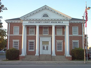
Polk County is a county located in the northwestern part of the U.S. state of Georgia. As of the 2020 census, the population was 42,853. The county seat is Cedartown. The county was created on December 20, 1851, by an act of the Georgia General Assembly and named after James K. Polk, the eleventh President of the United States.

<span class="mw-page-title-main">Murray County, Georgia</span> County in Georgia, United States

Murray County is a county located in the northwestern part of the U.S. state of Georgia. As of the 2020 census, the population was 39,973. The county seat is Chatsworth.

<span class="mw-page-title-main">Hall County, Georgia</span> County in Georgia, United States

Hall County is a county located in the northeast portion of the U.S. state of Georgia. As of the 2020 census, the population was 203,136, up from 179,684 at the 2010 census. The county seat is Gainesville. The entirety of Hall County comprises the Gainesville, Georgia, Metropolitan Statistical Area, which is also part of the Atlanta-Athens-Clarke County-Sandy Springs, Combined Statistical Area.

<span class="mw-page-title-main">Gordon County, Georgia</span> County in Georgia, United States

Gordon County is a county located in the northwestern part of the U.S. state of Georgia. As of the 2020 census, the population was 57,544. The county seat is Calhoun. Gordon County comprises the Calhoun, GA Micropolitan Statistical Area, which is included in the Atlanta–Athens-Clarke County–Sandy Springs, GA-AL CSA.

<span class="mw-page-title-main">Floyd County, Georgia</span> County in Georgia, United States

Floyd County is a county located in the northwestern part of the U.S. state of Georgia. As of the 2020 United States Census, the population was 98,584. The county seat is Rome.

<span class="mw-page-title-main">Cherokee County, Georgia</span> County in Georgia, United States

Cherokee County is located in the US state of Georgia. As of the 2020 Census, the population was 266,620. The county seat is Canton. The county Board of Commissioners is the governing body, with members elected to office. Cherokee County is included in the Atlanta Metropolitan Area.

<span class="mw-page-title-main">Catoosa County, Georgia</span> County in Georgia, United States

Catoosa County is a county located in the northwestern part of the U.S. state of Georgia. As of the 2020 census, the population was 67,872. The county seat is Ringgold. The county was created on December 5, 1853. The meaning of the Cherokee language name "Catoosa" is obscure: "Catoosa" may come from the Cherokee words gatusi or gatu'gitse.

<span class="mw-page-title-main">Emerson, Georgia</span> City in Georgia, United States

Emerson is a city in far southern Bartow County, Georgia, United States, on highways US-41/GA-3, GA-293, and I-75. The population was 1,470 at the 2010 census, an increase of 34% over the 2000 count of 1,092.

<span class="mw-page-title-main">Holly Springs, Georgia</span> City in Georgia, United States

Holly Springs is a city in Cherokee County, Georgia, United States. The population was 9,189 as of the 2010 census, up from 3,195 in 2000.

<span class="mw-page-title-main">Nelson, Georgia</span> City in Georgia, United States

Nelson is a city in Pickens and Cherokee Counties, Georgia, United States. At the 2020 census, the population was 1,145. It is part of the Atlanta metropolitan area.

<span class="mw-page-title-main">Waleska, Georgia</span> City in Georgia, United States

Waleska is a city in Cherokee County, Georgia, United States. The population was 644 at the 2010 census.

<span class="mw-page-title-main">Powder Springs, Georgia</span> City in Georgia, United States

Powder Springs is a city in Cobb County, Georgia, United States. The population was 13,940 at the 2010 census, with an estimated population for 2019 of 15,758. The 12,000-capacity Walter H. Cantrell Stadium is located in Powder Springs. It is used mostly for football and soccer matches.

<span class="mw-page-title-main">East Ellijay, Georgia</span> City in Georgia, United States

East Ellijay is a city in Gilmer County, Georgia, United States. The population was 546 at the 2010 census, down from 707 in 2000.

<span class="mw-page-title-main">Fairmount, Georgia</span> City in Georgia, United States

Fairmount is a city in Gordon County, Georgia, United States. As of the 2010 census it had a population of 720. Gordon County is home to New Echota, which was once the Cherokee Nation's capital. It was the origin of the Cherokee written language and newspaper, the Cherokee Phoenix.

<span class="mw-page-title-main">Jasper, Georgia</span> City and county seat in Georgia, United States

Jasper is a city in Pickens County, Georgia, United States. The population was 3,684 at the 2010 census. The city is the county seat of Pickens County.

<span class="mw-page-title-main">Hiawassee, Georgia</span> City in Georgia, United States

Hiawassee is the county seat of Towns County, Georgia, United States. The community's population was 880 at the 2010 census. Its name is derived from the Cherokee—or perhaps Creek—word Ayuhwasi, which means meadow, Hiawassee is also known in the novel "Restart" by Gordon Korman.

<span class="mw-page-title-main">Rossville, Georgia</span> City in Georgia, United States

Rossville is a city in Walker County, Georgia, United States. The population was 3,980 at the 2020 census. It is part of the Chattanooga, TN–GA Metropolitan Statistical Area.

References

  1. "2020 U.S. Gazetteer Files". United States Census Bureau. Retrieved December 18, 2021.
  2. "U.S. Census website". United States Census Bureau . Retrieved January 31, 2008.
  3. "US Board on Geographic Names". United States Geological Survey. October 25, 2007. Retrieved January 31, 2008.
  4. 1 2 "2020 Census Count by Georgia City" (PDF). Georgia General Assembly. Retrieved July 2, 2023.
  5. Woolsey, Matt (July 16, 2007). "America's Fastest-Growing Suburbs". Forbes.com. Archived from the original on October 11, 2007. Retrieved September 16, 2007.
  6. "Woodstock, GA".
  7. Acts of the General Assembly of the State of Georgia. Clark & Hines, State Printers. 1898. p. 368.
  8. Krakow, Kenneth K. (1975). Georgia Place-Names: Their History and Origins (PDF). Macon, GA: Winship Press. p. 257. ISBN   0-915430-00-2.
  9. "Cherokee County Historical Society". Archived from the original on March 24, 2014. Retrieved March 24, 2014.
  10. "Geographic Identifiers: 2010 Demographic Profile Data (G001): Canton city, Georgia". U.S. Census Bureau, American Factfinder. Archived from the original on February 12, 2020. Retrieved July 24, 2014.
  11. "Census of Population and Housing". Census.gov. Retrieved June 4, 2015.
  12. "Explore Census Data". data.census.gov. Retrieved December 14, 2021.
  13. "2010 Census Data". US Census Bureau. Archived from the original on February 12, 2020. Retrieved August 30, 2011.
  14. "Woodstock Memorial-Woodstock, Georgia Image". Waymarking.com.
  15. "34°06'05.5"N 84°31'07.4"W". 34°06'05.5"N 84°31'07.4"W.
  16. "Cherokee County names bridge after late teen". August 8, 2013.
  17. "." Greenprints Alliance Project. Accessed October 10, 2012.
  18. Dixon, Crystal (January 1, 2010). "Banner Year". Cherokee Tribune. Retrieved January 3, 2010.
  19. "Woodstock Ga Fire Department". City of Woodstock Ga. Retrieved January 24, 2018.
  20. "Woodstock, GA - Official Website". Woodstockga.gov. Retrieved July 12, 2018.