Carroll County | |
---|---|
Coordinates: 33°35′N85°05′W / 33.58°N 85.08°W | |
Country | United States |
State | Georgia |
Founded | June 9, 1826 |
Named for | Charles Carroll of Carrollton |
Seat | Carrollton |
Largest city | Carrollton |
Area | |
• Total | 504 sq mi (1,310 km2) |
• Land | 499 sq mi (1,290 km2) |
• Water | 4.8 sq mi (12 km2) 0.9% |
Population (2020) | |
• Total | 119,148 [1] |
Time zone | UTC−5 (Eastern) |
• Summer (DST) | UTC−4 (EDT) |
Congressional district | 3rd |
Website | www |
Carroll County is a county located in the northwestern part of the State of Georgia. As of the 2020 census, its population was 119,148. [2] [1] Its county seat is the city of Carrollton. [3] Carroll County is included in the Atlanta-Sandy Springs-Roswell metropolitan statistical area and is also adjacent to Alabama on its western border.
The lands of Lee, Muscogee, Troup, Coweta, and Carroll counties were ceded by the Creek people in the Treaty of Indian Springs (1825). This was a huge amount of land in Georgia and Alabama, the last remaining portion of the Creeks' territory, and it was ceded by William McIntosh, the chief of the Lower Creek and a member of the National Council. This cession violated the Law, the Code of 1818 that protected communal tribal land. The Creek National Council ordered the execution of McIntosh and other signatories to the treaty for what it considered treason.
McIntosh was killed at his plantation home, at what has been preserved as the McIntosh Reserve. Menawa and a force of 100-150 Law Defenders from Upper Town lands ceded in this treaty carried out the executions of two other men, including Samuel Hawkins, one of McIntosh's sons-in-law. Benjamin Hawkins Jr., another son-in-law, was also named for execution but he escaped, and soon moved to East Texas with his wife and family. Both of the Hawkins brothers were sons of Benjamin Hawkins, the longstanding US Indian Supervisor of the Creek.
The boundaries of Carroll County were created by the Georgia General Assembly on June 9, 1826, but the county was not named until December 14, 1826. It was named for Charles Carroll of Carrollton, at that time the last surviving signer of the U.S. Declaration of Independence, as was Carrollton, the county seat. [4]
When the county was first organized, the legislature designated the county seat as Old Carrollton, Georgia, but in 1830 it was moved to Carrollton. [5]
This county originally extended from the Chattahoochee River to the Alabama state line on the east and on the west, with its northern boundary at the Cherokee Nation, just north of present-day Interstate 20. As population increased, this land was divided into Carroll, Douglas, and Heard counties, and parts of Haralson and Troup counties. The portion that became Douglas County was once Campbell County which no longer exists (it was divided between Douglas and Fulton counties).
Because the county had few slaves compared to counties developed for cotton plantations, it was called the Free State of Carroll during the 1850s. Even before the cession of territory by the Cherokee in the late 1830s, some white settlers lived in the northern part of the county in the area of Villa Rica.
Carroll County was the site of Georgia's first Gold Rush.
For a time Carroll County was the home of Horace King (architect). King helped build Moore's Bridge over the Chattahoochee River at Whitesburg. Moores Bridge was burned by Union soldiers during the Civil War. During the American Civil War, the county provided the Bowdon Volunteers and the Carroll Boys, which were a part of Cobb's Legion.
On August 21, 1995, Atlantic Southeast Airlines Flight 529 crashed in a field near Carrollton, Georgia. Nine of the 29 passengers and crew were killed in the crash.
In February 2008 several tornadoes hit Carroll County, destroying several homes and damaging many more. On May 11, 2008 (Mother's Day) some of the same areas were hit by more tornadoes. The Mother's Day tornadoes destroyed and damaged many homes and businesses.
On September 21, 2009, portions of Carroll County were flooded after eight days of heavy rainfall, resulting in multiple deaths. The flooding initially closed more than 60 highways and roads, and it destroyed a number of bridges. Early estimates of the damage totaled $22 million.
According to the U.S. Census Bureau, the county has a total area of 504 square miles (1,310 km2), of which 499 square miles (1,290 km2) is land and 4.8 square miles (12 km2) (0.9%) is water. [6]
The western two-thirds of Carroll County, in a line from Roopville northeast to Villa Rica, is located in the Upper Tallapoosa River sub-basin of the ACT River Basin (Alabama-Coosa-Tallapoosa River Basin), while the eastern third, east of that same line, is located in the Middle Chattahoochee River-Lake Harding sub-basin of the ACF River Basin (Apalachicola-Chattahoochee-Flint River Basin). [7]
*The eastern half of Villa Rica is in Douglas County
Census | Pop. | Note | %± |
---|---|---|---|
1830 | 3,419 | — | |
1840 | 5,252 | 53.6% | |
1850 | 9,357 | 78.2% | |
1860 | 11,991 | 28.2% | |
1870 | 11,782 | −1.7% | |
1880 | 16,901 | 43.4% | |
1890 | 22,301 | 32.0% | |
1900 | 26,576 | 19.2% | |
1910 | 30,855 | 16.1% | |
1920 | 34,752 | 12.6% | |
1930 | 34,272 | −1.4% | |
1940 | 34,156 | −0.3% | |
1950 | 34,112 | −0.1% | |
1960 | 36,451 | 6.9% | |
1970 | 45,404 | 24.6% | |
1980 | 56,346 | 24.1% | |
1990 | 71,422 | 26.8% | |
2000 | 87,268 | 22.2% | |
2010 | 110,527 | 26.7% | |
2020 | 119,148 | 7.8% | |
2023 (est.) | 127,098 | [8] | 6.7% |
U.S. Decennial Census [9] 1790-1880 [10] 1890-1910 [11] 1920-1930 [12] 1930-1940 [13] 1940-1950 [14] 1960-1980 [15] 1980-2000 [16] 2010 [17] 2020 [18] |
Race / Ethnicity | Pop 2000 [19] | Pop 2010 [17] | Pop 2020 [18] | % 2000 | % 2010 | % 2020 |
---|---|---|---|---|---|---|
White alone (NH) | 69,258 | 80,531 | 80,725 | 79.36% | 72.86% | 67.75% |
Black or African American alone (NH) | 14,177 | 19,862 | 21,781 | 16.25% | 17.97% | 18.28% |
Native American or Alaska Native alone (NH) | 206 | 296 | 271 | 0.24% | 0.27% | 0.23% |
Asian alone (NH) | 532 | 836 | 1,104 | 0.61% | 0.76% | 0.93% |
Pacific Islander alone (NH) | 16 | 19 | 21 | 0.02% | 0.02% | 0.02% |
Other race alone (NH) | 111 | 249 | 505 | 0.13% | 0.23% | 0.42% |
Mixed race or Multiracial (NH) | 725 | 1,934 | 5,155 | 0.83% | 1.75% | 4.33% |
Hispanic or Latino (any race) | 2,243 | 6,800 | 9,586 | 2.57% | 6.15% | 8.05% |
Total | 87,268 | 110,527 | 119,148 | 100.00% | 100.00% | 100.00% |
As of the 2020 United States census, there were 119,148 people, 42,798 households, and 30,346 families residing in the county.
The Southern Railway ran several daily passenger trains, including the Kansas City-Florida Special, the Sunnyland and an Atlanta-Birmingham section of the Piedmont Limited, making full stops in Bremen. These trains made flag or signal stops in Villa Rica as well. [20] The last trains made stops in 1967. [21]
Carroll County has voted Republican consistently since 1984. Unlike most counties in the Atlanta metropolitan area, Carroll County as a whole has trended right for more than a decade.The county voted for Donald Trump by 39 percentage points in 2020 and later voted for Governor Kemp by almost 48 percentage points in the 2022 midterms
Year | Republican | Democratic | Third party | |||
---|---|---|---|---|---|---|
No. | % | No. | % | No. | % | |
2020 | 37,476 | 68.76% | 16,236 | 29.79% | 790 | 1.45% |
2016 | 30,029 | 67.54% | 12,464 | 28.03% | 1,966 | 4.42% |
2012 | 28,280 | 67.86% | 12,688 | 30.45% | 704 | 1.69% |
2008 | 28,661 | 65.76% | 14,334 | 32.89% | 588 | 1.35% |
2004 | 24,837 | 70.27% | 10,224 | 28.92% | 286 | 0.81% |
2000 | 16,326 | 63.42% | 8,752 | 34.00% | 663 | 2.58% |
1996 | 11,157 | 51.25% | 8,438 | 38.76% | 2,174 | 9.99% |
1992 | 10,750 | 47.60% | 8,404 | 37.21% | 3,432 | 15.20% |
1988 | 10,754 | 69.20% | 4,706 | 30.28% | 81 | 0.52% |
1984 | 11,436 | 67.17% | 5,590 | 32.83% | 0 | 0.00% |
1980 | 5,815 | 40.17% | 8,202 | 56.66% | 458 | 3.16% |
1976 | 3,640 | 26.59% | 10,050 | 73.41% | 0 | 0.00% |
1972 | 8,296 | 79.36% | 2,158 | 20.64% | 0 | 0.00% |
1968 | 3,135 | 26.19% | 2,326 | 19.43% | 6,509 | 54.38% |
1964 | 4,984 | 50.96% | 4,794 | 49.02% | 2 | 0.02% |
1960 | 1,729 | 26.90% | 4,698 | 73.10% | 0 | 0.00% |
1956 | 1,712 | 26.07% | 4,855 | 73.93% | 0 | 0.00% |
1952 | 1,194 | 18.65% | 5,207 | 81.35% | 0 | 0.00% |
1948 | 526 | 14.33% | 2,671 | 72.76% | 474 | 12.91% |
1944 | 704 | 17.45% | 3,331 | 82.55% | 0 | 0.00% |
1940 | 616 | 13.90% | 3,808 | 85.92% | 8 | 0.18% |
1936 | 653 | 14.93% | 3,717 | 84.98% | 4 | 0.09% |
1932 | 284 | 8.01% | 3,232 | 91.14% | 30 | 0.85% |
1928 | 2,112 | 52.47% | 1,913 | 47.53% | 0 | 0.00% |
1924 | 526 | 20.72% | 1,784 | 70.29% | 228 | 8.98% |
1920 | 1,227 | 42.92% | 1,632 | 57.08% | 0 | 0.00% |
1916 | 118 | 5.48% | 1,621 | 75.33% | 413 | 19.19% |
1912 | 81 | 4.75% | 1,192 | 69.95% | 431 | 25.29% |
1908 | 505 | 28.26% | 917 | 51.32% | 365 | 20.43% |
1904 | 400 | 18.24% | 1,187 | 54.13% | 606 | 27.63% |
1900 | 697 | 35.43% | 1,270 | 64.57% | 0 | 0.00% |
1896 | 733 | 31.88% | 1,490 | 64.81% | 76 | 3.31% |
1892 | 543 | 16.31% | 2,137 | 64.19% | 649 | 19.50% |
1888 | 349 | 16.51% | 1,710 | 80.89% | 55 | 2.60% |
1884 | 499 | 19.52% | 2,058 | 80.48% | 0 | 0.00% |
1880 | 329 | 20.97% | 1,240 | 79.03% | 0 | 0.00% |
Clay County is a county located in the southwestern part of the U.S. state of Georgia. As of the 2020 census, the population was 2,848, making it the fourth-least populous county in Georgia. The county seat is Fort Gaines.
Talbot County is a county located in the west central portion of the U.S. state of Georgia. The 2020 census showed a population of 5,733. The county seat and largest city is Talbotton.
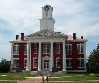
Stewart County is a county located in the west central portion of the U.S. state of Georgia. As of the 2020 census, the population was 5,314. The county seat is Lumpkin. The county was created on December 23, 1830.
Seminole County is a county located in the southwestern corner of U.S. state of Georgia. As of the 2020 census, the population was 9,147. The county seat is Donalsonville.
Randolph County is a county located in the southwestern portion of the U.S. state of Georgia and is considered part of the Black Belt, historically an area of plantations. As of the 2020 census, the population was 6,425, roughly one-third of its peak population in 1910, when there were numerous agricultural workers. The county seat is Cuthbert.
Peach County is a county located in the central portion of the U.S. state of Georgia. As of the 2020 census, the population was 27,981. Its county seat is Fort Valley. Founded in 1924, it is the state's newest county, taken from Houston and Macon counties on July 18 of that year. Its namesake is the peach on account of it being located in a peach-growing district.
Paulding County is a county located in the northwestern part of the U.S. state of Georgia. Part of Metro Atlanta, it had an estimated population of 168,661 in 2020. The county seat is Dallas.
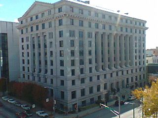
Muscogee County is a county located on the central western border of the U.S. state of Georgia named after the Muscogee that originally inhabited the land with its western border with the state of Alabama that is formed by the Chattahoochee River. As of the 2020 census, the population was 206,922. Its county seat and only city is Columbus, with which it has been a consolidated city-county since the beginning of 1971.
Monroe County is a county located in the central portion of the U.S. state of Georgia. As of the 2020 census, the population was 27,957. The county seat is Forsyth. The county was created on May 15, 1821. The county was named for James Monroe. Monroe County is included in the Macon, GA metropolitan statistical area.
Miller County is a county located in the southwestern part of the U.S. state of Georgia. As of the 2020 census, the population was 6,000. The county seat is Colquitt. The county was created on February 26, 1856, and named after Andrew Jackson Miller (1806–56), president of the Medical College of Georgia.
Lamar County is a county located in the west central portion of the U.S. state of Georgia. As of the 2020 census, the population was 18,500. The county seat is Barnesville.
Heard County is a county located in the west central portion of the U.S. state of Georgia. At the 2020 census, the population was 11,412, down from 11,834 in 2010. The county seat is Franklin. The county was created on December 22, 1830.
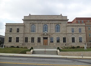
Fulton County is a county in the north-central portion of the U.S. state of Georgia. As of the 2020 United States census, the population was 1,066,710, making it the state's most populous county and its only one with over one million inhabitants. Its county seat and most populous city is Atlanta, the state capital. About 90% of the City of Atlanta is within Fulton County; the remaining portion is in DeKalb County. Fulton County is part of the Atlanta–Sandy Springs–Roswell, GA Metropolitan Statistical Area.
Early County is a county located on the southwest border of the U.S. state of Georgia. As of the 2020 census, the population was 10,854. The county seat is Blakely, where the Early County Courthouse is located. Created on December 15, 1818, it was named for Peter Early, 28th Governor of Georgia. The county is bordered on the west by the Chattahoochee River, forming the border with Alabama.
Douglas County is a county located in the north central portion of the U.S. state of Georgia. As of the 2020 U.S. Census, the population was 144,237, having more than doubled since 1990. The county seat is Douglasville. The City of Villa Rica, and a small portion of Austell are both also located in Douglas County. Douglas County is included in the Atlanta-Sandy Springs-Roswell, GA Metropolitan Statistical Area. It has attracted new residents as jobs have increased in the Atlanta area.
Dougherty County is located in the southwestern portion of the U.S. state of Georgia. As of the 2020 census, the population was 85,790. The county seat and sole incorporated city is Albany.
Dooly County is a county located in the central portion of the U.S. state of Georgia. As of the 2020 census, the population was 11,208. The county seat is Vienna. The county was created by an act of the Georgia General Assembly on May 15, 1821, and named for Colonel John Dooly, a Georgia American Revolutionary War fighter. It was one of the original landlot counties created from land ceded from the Creek Nation.
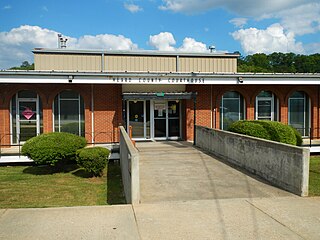
Baker County is a county in Georgia. As of the 2020 census, the population was 2,876. The county seat and only city is Newton. The county was created December 12, 1825, from the eastern portion of Early County by an act of the Georgia General Assembly and is named for Colonel John Baker, a hero of the American Revolutionary War.
Whitesburg is a town in Carroll County, Georgia, United States. The population was 588 at the 2010 census.
Georgetown is a city in Quitman County, Georgia, United States. It is on the Alabama-Georgia state line next to Walter F. George Lake and across the Chattahoochee River from Eufaula, Alabama. Per the 2020 census, the population was 2,235. In 2006, Georgetown and Quitman County voted to consolidate their governments, becoming the smallest such consolidated entity in the Lower 48 states.