Harris County is a county located in the west-central portion of the U.S. state of Georgia; its western border with the state of Alabama is formed by the Chattahoochee River. As of the 2020 census, the population was 34,668. The county seat is Hamilton. The largest city in the county is Pine Mountain, a resort town that is home to the Franklin D. Roosevelt State Park. Harris County was created on December 14, 1827, and named for Charles Harris, a Georgia judge and attorney.
West Point is a city in Troup and Harris counties in the U.S. state of Georgia. It is located approximately halfway between Montgomery, Alabama and Atlanta along Interstate 85. As of 2020, its population was 3,719. Most of the city is in Troup County, which is part of the LaGrange micropolitan statistical area, and hence part of the Atlanta-Athens-Clarke County-Sandy Springs, GA combined statistical area. A sliver in the south is in Harris County, which is part of the Columbus metropolitan statistical area.
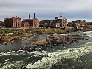
Columbus is a consolidated city-county located on the west-central border of the U.S. state of Georgia. Columbus lies on the Chattahoochee River directly across from Phenix City, Alabama. It is the county seat of Muscogee County, with which it officially merged in 1970; the original merger excluded Bibb City, which joined in 2000 after dissolving its own city charter.

The Susquehanna River is a major river located in the Mid-Atlantic region of the United States, overlapping between the lower Northeast. At 444 miles (715 km) long, it is the longest river on the East Coast of the United States. By watershed area, it is the 16th-largest river in the United States, and also the longest river in the early 21st-century continental United States without commercial boat traffic.

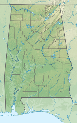
The Chattahoochee River forms the southern half of the Alabama and Georgia border, as well as a portion of the Florida and Georgia border. It is a tributary of the Apalachicola River, a relatively short river formed by the confluence of the Chattahoochee and Flint rivers and emptying from Florida into Apalachicola Bay in the Gulf of Mexico. The Chattahoochee River is about 430 miles (690 km) long. The Chattahoochee, Flint, and Apalachicola rivers together make up the Apalachicola–Chattahoochee–Flint River Basin. The Chattahoochee makes up the largest part of the ACF's drainage basin.

The Little Tennessee River is a 135-mile (217 km) tributary of the Tennessee River that flows through the Blue Ridge Mountains from Georgia, into North Carolina, and then into Tennessee, in the southeastern United States. It drains portions of three national forests— Chattahoochee, Nantahala, and Cherokee— and provides the southwestern boundary of the Great Smoky Mountains National Park.

The Tombigbee River is a tributary of the Mobile River, approximately 200 mi (325 km) long, in the U.S. states of Mississippi and Alabama. Together with the Alabama, it merges to form the short Mobile River before the latter empties into Mobile Bay on the Gulf of Mexico. The Tombigbee watershed encompasses much of the rural coastal plain of western Alabama and northeastern Mississippi, flowing generally southward. The river provides one of the principal routes of commercial navigation in the southern United States, as it is navigable along much of its length through locks and connected in its upper reaches to the Tennessee River via the Tennessee-Tombigbee Waterway.

The Coosa River is a tributary of the Alabama River in the U.S. states of Alabama and Georgia. The river is about 280 miles (450 km) long.

The Tallapoosa River runs 265 miles (426 km) from the southern end of the Appalachian Mountains in Georgia, United States, southward and westward into the Appalachian foothills in Alabama. It is formed by the confluence of McClendon Creek and Mud Creek in Paulding County, Georgia. Lake Martin at Dadeville, Alabama is a large and popular water recreation area formed by a dam on the river. The Tallapoosa joins the Coosa River about 10 miles (16 km) northeast of Montgomery near Wetumpka to form the Alabama River.

Lake Martin is located in Tallapoosa, Elmore and Coosa counties in Alabama. It is a 44,000-acre (178 km2) reservoir with over 750 miles (1,200 km) of wooded shoreline. Lake Martin is a reservoir, enlarged by the construction of Martin Dam on the Tallapoosa River. The Martin Dam powerhouse is used to generate hydroelectric power for the Alabama Power Company. Construction on Martin Dam began in 1923 and was completed in 1926, creating what was, at that time, the largest human-made body of water in the world. Originally known as Cherokee Bluffs for the geological formation upon which it was built, the dam was renamed in 1936 in honor of Thomas Martin, the then-president of Alabama Power Company. Alabama Power and Russell Lands own some of the shoreline.

Cranberry Lake is a lake on the east branch of the Oswegatchie River in the Adirondack Park in New York in the United States. It is the third largest lake in the Adirondack Park. About 75 percent of the shoreline is owned by the State of New York. The 118,000-acre (480 km2) Five Ponds Wilderness Area abuts its south shore, and the Cranberry Lake Wild Forest covers much of its remaining shoreline.
There were several historic mills around the metro Atlanta area, for which many of its current-day roads are still named. Most of the mills date back to the 1820s and 1830s, and were built along the area's many streams. The locations of many of these mills are shown on a map of 1875 showing U. S. military operations around Atlanta in 1864. This map is now located in the U. S. Library of Congress but can be seen on the webpage linked here.
Chattahoochee River National Recreation Area (CRNRA) preserves a series of sites between Atlanta and Lake Sidney Lanier along the Chattahoochee River in Georgia, U.S. The 48-mile (77 km) stretch of the river affords public recreation opportunities and access to historic sites. The national recreation area, a National Park Service unit, was established on August 15, 1978, by President Jimmy Carter.

Logan Martin Lake is a reservoir located in east central Alabama on the Coosa River approximately 30 miles (48 km) east of Birmingham, Alabama. This 17,000-acre (69 km2) reservoir was built in 1965 by Alabama Power Company. The lake, nicknamed Lake of a Thousand Coves by locals, has 275 miles (443 km) of shoreline along its 48.5-mile (78.1 km) length sandwiched between Logan Martin Dam on the south and Neely Henry Dam on the north. The depth of the lake is 35 to 110 feet (34 m) with only five feet average water level variance.

Goose Creek is a 53.9-mile-long (86.7 km) tributary of the Potomac River in Fauquier and Loudoun counties in northern Virginia. It comprises the principal drainage system for the Loudoun Valley.
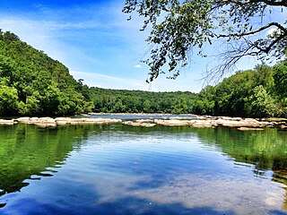
Goat Rock Lake is a 940-acre (3.8 km2) reservoir on the Chattahoochee River, which lies directly south of Bartlett's Ferry Dam and north of Lake Oliver. The lake is created by the Goat Rock Dam and Generating Plant. The name of the dam and lake date to the construction of the dam in 1912. Reportedly, construction workers saw goats jumping onto rocks in the river.
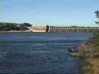
Lake Oliver is a 2,150-acre (8.7 km2) reservoir on the Chattahoochee River, which lies south of Goat Rock Dam. The lake is created by the Oliver Dam and Generating Plant, which was completed in 1959 by Georgia Power.

Chatuge Dam is a flood control and hydroelectric dam on the Hiwassee River in Clay County, in the U.S. state of North Carolina. The dam is the uppermost of three dams on the river owned and operated by the Tennessee Valley Authority, which built the dam in the early 1940s for flood storage and to provide flow regulation at Hiwassee Dam further downstream. The dam impounds the 7,000-acre (2,800 ha) Chatuge Lake, which straddles the North Carolina-Georgia state line. While originally built solely for flood storage, a generator installed at Chatuge in the 1950s gives the dam a small hydroelectric output. At the time it was built, Chatuge Dam was the highest earthen dam in the world until the Aswan Dam was built in Egypt in 1964. The dam and associated infrastructure was listed on the National Register of Historic Places in 2017.
Lay Dam is a hydroelectric power dam on the Coosa River in Chilton County and Coosa County, near Clanton, Alabama.

West Point Lake is a man-made reservoir located mostly in west-central Georgia on the Chattahoochee River and maintained by the U.S. Army Corps of Engineers (USACE). The Chattahoochee river flows in from the north, before flowing through the West Point Dam, which impounds the lake, and continuing to Columbus, Georgia. Of the four major USACE lakes in the ACF River Basin, West Point Lake is the smallest by area containing 25,864 acres (10,467 ha) of water, and has the second shortest shoreline at 604 mi (972 km). The purposes of the reservoir are to provide flood control, hydroelectric power, and water storage to aid the navigation of the lower Chattahoochee.