Lake Strom Thurmond

Last updated
Lake Strom Thurmond
Sunset clarkshill-lake.jpg
Sunset on the Georgia side of Lake Strom Thurmond (Clarks Hill Lake), April 2006
USA Georgia relief location map.svg
Red pog.svg
Lake Strom Thurmond
Usa edcp relief location map.png
Red pog.svg
Lake Strom Thurmond
Location McCormick County, SC & Lincoln County, GA & Columbia County, GA McDuffie county Wilkes county
Coordinates 33°39′40″N82°11′57″W / 33.66111°N 82.19917°W / 33.66111; -82.19917
Lake type reservoir
Primary inflows Savannah River
Primary outflows Savannah River
Basin  countriesUnited States
Surface area 71,100 acres (288 km2)
Max. depth180 ft (54.8 m)
Surface elevation330 ft (100 m)

Lake Strom Thurmond, officially designated J. Strom Thurmond Reservoir [1] at the federal level, and Clarks Hill Lake by the state of Georgia, [2] is a man-made reservoir at the border between the U.S. states of Georgia and South Carolina in the Savannah River Basin.

Contents

Description

The J. Strom Thurmond Dam, as seen from the fishing pier below, September 2007 ThurmondDam.jpg
The J. Strom Thurmond Dam, as seen from the fishing pier below, September 2007

The reservoir was created by the J. Strom Thurmond Dam during 1951 and 1952 by the U.S. Army Corps of Engineers near the confluence of the Little River and the Savannah River. At 71,000 acres (290 km2), it is the third-largest artificial lake east of the Mississippi River, behind the Kentucky Lake on the Tennessee River and Lake Marion on the Santee River. The J. Strom Thurmond Dam is located upstream from Augusta, Georgia.

The Thurmond Lake is one of the Southeast's largest and most popular public recreation lakes. The dam was built by the U.S. Army Corps of Engineers between 1946 and 1954, but the lake was filled during 1951 and 1952 as part of a flood control, hydropower, and navigation project. [3] Its legally authorized purposes now include recreation, water quality, water supply, and fish and wildlife management. Each year, millions of people use the many public parks, marinas, and campgrounds conveniently located around Thurmond Lake for a variety of outdoor recreational experiences, making it one of the 10 most visited Corps lakes in the nation.

Thurmond Lake is a man-made lake bordering Georgia and South Carolina on the Savannah, Broad, and Little Rivers. The lake is created by the J. Strom Thurmond Dam located on the Savannah River 22 miles (35 km) above Augusta, Georgia and 239.5 miles (385.4 km) above the mouth of the Savannah River. The lake extends 39.4 miles (63.4 km) up the Savannah River, 29 miles (47 km) up the Little River in Georgia, and 6.5 miles (10.5 km) up the Broad River in Georgia, and 17 miles (27 km) up the Little River in South Carolina, at normal pool elevation of 330 mean sea level, Thurmond Lake comprises nearly 71,100 acres (287 km2) of water with a shoreline of 1,200 miles (1,900 km). [4] The entire Thurmond "project" contains 151,000 acres (611 km2) of land and water.

J. Strom Thurmond Lake and Dam is the first Corps of Engineers project to be built in the Savannah River Basin. Hartwell Lake and Dam the second project built in the basin was completed in 1963, and a third project, Richard B. Russell Lake and Dam was completed in 1985. Together these three lakes form a chain of lakes that is 120 miles (190 km) long. Congress authorized Thurmond Lake in 1944 and construction began in 1946. The project was completed in 1954 at a cost of $79 million.

History

Due to a clerical error in the original Congressional Authorization, the project was officially authorized to build "Clark Hill Dam", creating "Clark Hill Lake", with the "s" at the end of "Clarks" accidentally omitted. The authorization document outlined the plan of development for the basin with authorized purposes of power production, incidental flood control, and navigation. Later, recreation, water quality, water supply, and fish and wildlife management were added as authorized purposes. Twenty-six years after the construction of the dam, both the dam and lake were renamed to "Clarks Hill Dam" and "Clarks Hill Lake", respectively, in legislation sponsored by Strom Thurmond. [5]

The 1966 Flood Control Act authorized the building of Trotters Shoals Lake and Dam on the Savannah River between Clarks Hill Lake and Hartwell Lake. This lake was later renamed to commemorate a late senator from Georgia, Richard B. Russell, who was an important supporter of building dams on the river. This created a movement to rename Clarks Hill Lake after J. Strom Thurmond, the longest-serving senator in US history, who was from Edgefield on the South Carolina side of the lake. This movement gained support due to the senator's popularity in the area, and in 1988 the project was congressionally renamed "J. Strom Thurmond Dam and Lake at Clarks Hill."

Renaming of lake

Until 1987, the lake was called Clarks Hill Lake after the nearby South Carolina town of Clarks Hill named for Augusta businessman John Mulford Clark (1813–1880). (See "Years Gone By: Information on the Origin of the Names Clarks Hill," Reservoirs—Clarks II Subjects, DOC-1991, Georgia Archives, Morrow.) On December 3, 1987, two days before long-time South Carolina Senator Strom Thurmond's 85th birthday, Representative Butler Derrick of South Carolina introduced a bill before Congress to rename the lake after Thurmond. [6] [5]

The bill quickly passed through Congress and was signed into law by President Ronald Reagan on December 23, 1987. [7] Many residents of both states were upset by the sudden change of name of the lake and the dam, which had not been open to public comment. [8] In response, a group of Georgia legislators, led by Representative Doug Barnard, Jr. (who was the only Georgia co-sponsor of the original 1987 bill) introduced a federal bill to rename the lake as "Clarks Hill" once again. That bill, however, was unsuccessful, and the name remained unchanged.

On April 4, 1989, the State of Georgia legislature passed House Resolution No. 115 making "Clarks Hill" the official state name for both the dam and associated reservoir. [2] Accordingly, Georgia's state map still refers to the lake as Clarks Hill. [9] Many residents of Georgia as well as South Carolina still refer to the lake by its original name.

See also

Related Research Articles

<span class="mw-page-title-main">Lincoln County, Georgia</span> County in Georgia, United States

Lincoln County is a county located in the east central portion of the U.S. state of Georgia. As of the 2020 census, the population was 7,690. The county seat is Lincolnton. The county was created on February 20, 1796.

<span class="mw-page-title-main">Lincolnton, Georgia</span> City in Georgia, United States

Lincolnton is a city and the county seat of Lincoln County, Georgia, United States. The population was 1,480 at the 2020 census. It contains numerous houses and historic districts listed on the National Register of Historic Places. Both the city and the county were named for General Benjamin Lincoln, who served in the Continental Army during the American Revolution.

<span class="mw-page-title-main">Savannah River</span> River in the southeastern United States

The Savannah River is a major river in the Southeastern United States, forming most of the border between South Carolina and Georgia. Two tributaries of the Savannah, the Tugaloo River and the Chattooga River, form the northernmost part of the state border. The Savannah River drainage basin extends into the southeastern side of the Appalachian Mountains just inside North Carolina, bounded by the Eastern Continental Divide. The river is around 301 miles (484 km) long. The Savannah was formed by the confluence of the Tugaloo River and the Seneca River. Today this confluence is part of Lake Hartwell. The Tallulah Gorge is located on the Tallulah River, a tributary of the Tugaloo River that forms the northwest branch of the Savannah River.

<span class="mw-page-title-main">Jordan Lake</span> Lake in North Carolina, U.S.

B. Everett Jordan Lake is a reservoir in New Hope Valley, west of Cary and south of Durham in Chatham County, North Carolina, in the United States; the northernmost end of the lake extends into southwestern Durham County.

<span class="mw-page-title-main">Pick–Sloan Missouri Basin Program</span> Flood control

The Pick–Sloan Missouri Basin Program, formerly called the Missouri River Basin Project, was initially authorized by the Flood Control Act of 1944, which approved the plan for the conservation, control, and use of water resources in the Missouri River Basin.

<span class="mw-page-title-main">Lake Allatoona</span> Reservoir in Georgia, United States

Lake Allatoona is a U.S. Army Corps of Engineers reservoir on the Etowah River in northwestern part of the State of Georgia. This reservoir is mostly in southeastern Bartow County and southwestern Cherokee County. A small portion is located in Cobb County near Acworth.

<span class="mw-page-title-main">Jennings Randolph Lake</span> Reservoir in West Virginia, United States

Jennings Randolph Lake is a reservoir of 952 acres (3.85 km2) located on the North Branch Potomac River in Garrett County, Maryland and Mineral County, West Virginia. It is approximately 8 miles (13 km) upstream of Bloomington, Maryland, and approximately 5 miles (8.0 km) north of Elk Garden, West Virginia.

Strom may refer to:

<span class="mw-page-title-main">Gavins Point Dam</span> Dam in Nebraska and Yankton County, South Dakota.

Gavins Point Dam is a 1.9-mile-long (3 km) embankment rolled-earth and chalk-fill dam which spans the Missouri River and impounds Lewis and Clark Lake. The dam joins Cedar County, Nebraska with Yankton County, South Dakota a distance of 811.1 river miles (1,305 km) upstream of St. Louis, Missouri, where the river joins the Mississippi River. The dam and hydroelectric power plant were constructed as the Gavins Point Project from 1952 to 1957 by the United States Army Corps of Engineers as part of the Pick-Sloan Plan. The dam is located approximately 4 miles (6.4 km) west or upstream of Yankton, South Dakota.

<span class="mw-page-title-main">Lewis and Clark Lake</span> Man-made lake in Nebraska and South Dakota, United States

Lewis and Clark Lake is a 31,400 acre (130 km²) reservoir located on the border of the U.S. states of Nebraska and South Dakota on the Missouri River. The lake is approximately 25 miles (40 km) in length with over 90 miles (140 km) of shoreline and a maximum water depth of 45 feet (14 m). The lake is impounded by Gavins Point Dam and is managed by the U.S. Army Corps of Engineers, Omaha District.

<span class="mw-page-title-main">Pickwick Landing Dam</span> Dam in Tennessee, United States

Pickwick Landing Dam is a hydroelectric dam on the Tennessee River in Hardin County, in the U.S. state of Tennessee. The dam is one of nine dams on the river owned and operated by the Tennessee Valley Authority, which built the dam in the 1930s as part of a New Deal-era initiative to create a continuous navigation channel between the river's mouth and Knoxville, and bring economic development to the area. The dam impounds the 43,100-acre (17,400 ha) Pickwick Lake and its tailwaters are part of Kentucky Lake.

<span class="mw-page-title-main">Hartwell Dam</span> Dam in Georgia, USA

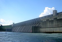
Hartwell Dam is a concrete and embankment dam located on the Savannah River at the border of South Carolina and Georgia, creating Lake Hartwell. The dam was built by the U.S. Army Corps of Engineers between 1955 and 1962 for the purposes of flood control, hydropower and navigation. The concrete and earthen structure spans 15,840 feet (4,828 m). The concrete section is 1,900 feet (579 m) long and rises 204 feet (62 m) above the riverbed at its apex. The Hartwell Dam currently produces 468 million KWh of electricity annually, has prevented over $40 million in flood damage since completion and also provides recreation, water quality, water supply, along with fish and wildlife management.

<span class="mw-page-title-main">Lake Hartwell</span> Reservoir on the Georgia/South Carolina border, United States

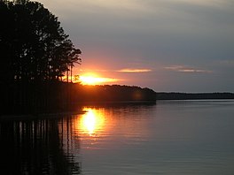
Lake Hartwell is a man-made reservoir bordering Georgia and South Carolina and encompassing parts of the Savannah, Tugaloo, and Seneca rivers. Lake Hartwell is one of the Southeastern United States' largest recreation lakes. The lake was created by the construction of the Hartwell Dam, completed in 1962 and located on the Savannah River seven miles (11 km) below the point at which the Tugaloo and Seneca Rivers join to form the Savannah. Extending 49 miles (79 km) up the Tugaloo and 45 miles (72 km) up the Seneca at normal pool elevation, the lake comprises nearly 56,000 acres (230 km2) of water with a shoreline of 962 miles (1,548 km). The entire Hartwell "Project" contains 76,450 acres (309 km2) of land and water. I-85 bisects Hartwell Lake and makes the area easily accessible to visitors.

<span class="mw-page-title-main">Nickajack Dam</span> Dam in Tennessee, United States

Nickajack Dam is a hydroelectric dam in Marion County in the U.S. state of Tennessee. It is one of nine dams on the Tennessee River owned and operated by the Tennessee Valley Authority, which built the dam in the mid-1960s to replace the outdated Hales Bar Dam 6 miles (9.7 km) upstream. The dam impounds the 10,370-acre (4,200 ha) Nickajack Lake and feeds into Guntersville Lake. Nickajack Dam is named for a Cherokee village once located just upstream from the dam. The village was the namesake for Nickajack Cave, which was partially flooded by the reservoir.

<span class="mw-page-title-main">Richard B. Russell Lake</span> Man-made lake created by the construction of Richard B. Russell Dam in South Carolina

Richard B. Russell Lake is a reservoir created by the U.S. Army Corps of Engineers by construction of Richard B. Russell Dam on the Savannah River bordering Elbert County, Georgia and Abbeville and Anderson counties in South Carolina. The lake impounds primarily the Savannah River but also includes Beaverdam Creek on the Georgia side and Rocky River on the South Carolina side. Filling of the lake began in October 1983, and was completed in December 1984 for a full pool elevation of 475 feet (145 m). Lake levels do not change much because the lake is designed to operate within 5 feet (1.5 m) of full pool compared to Hartwell and Thurmond, whose 35 feet (11 m) and 18 feet (5.5 m) of conservation storage respectively causes their levels to change more dramatically. This causes the lake to always look full.

<span class="mw-page-title-main">J. Strom Thurmond Dam</span> Dam in South Carolina, USA

J. Strom Thurmond Dam, also known in Georgia as Clarks Hill Dam, is a concrete-gravity and embankment dam located 22 miles (35 km) north of Augusta, Georgia on the Savannah River at the border of South Carolina and Georgia, creating Lake Strom Thurmond. U.S. Route 221 cross it. The dam was built by the U.S. Army Corps of Engineers between 1946 and 1954 for the purposes of flood control, hydroelectricity and downstream navigation. The concrete structure of the dam spans 1,096 feet (334 m) and rises 204 feet (62 m) above the riverbed, housing a power plant with an installed 380 MW capacity. The Dam has prevented over $3.1 million in estimated flood damage annually and also provides recreation, water quality, water supply, along with fish and wildlife management.

<span class="mw-page-title-main">Richard B. Russell Dam</span> Dam in Georgia, USA

Richard B. Russell Dam is a concrete-gravity and embankment dam located on the Savannah River at the border of South Carolina and Georgia, creating Richard B. Russell Lake. The dam was built by the U.S. Army Corps of Engineers between 1974 and 1985 for the purposes of flood control, hydroelectricity, recreation, additional stream flow regulation, water supply, and fish and wildlife management. The concrete structure of the dam spans 1,904 feet (580 m) and rises 210 feet (64 m) above the riverbed, housing a hydro-power plant with an installed 600 megawatts (800,000 hp) capacity. The Richard B. Russell Dam is the final large dam completed by the U.S. Army Corps in the Savannah River Basin and lies 30 miles downstream from the Hartwell Dam (1962) and 37 miles (60 km) upstream from the J. Strom Thurmond Dam (1954).

<span class="mw-page-title-main">New Savannah Bluff Lock and Dam</span> Dam in Georgia, United States

New Savannah Bluff Lock and Dam is a dam with inactive lock at the site of the dead town of New Savannah, Georgia on the Savannah River south of Augusta, Georgia.

References

  1. U.S. Geological Survey Geographic Names Information System: Lake Strom Thurmond
  2. 1 2 [ dead link ] Krinitzsky, Ellis L., Joseph B.Dunbar; Geological-Seismological Evaluation of Earthquake Hazards at J. Strom Thurmond Dam; US Army Corps of Engineers Waterways Experiment Station; Technical Report GL-93-18, August 1993.
  3. Army Corps of Engineers J. Strom Thurmond Lake and Dam Hydropower Archived 2009-12-05 at the Wayback Machine
  4. "Savannah District > About > Divisions and Offices > Operations Division > J. Strom Thurmond Dam and Lake". www.sas.usace.army.mil. Retrieved 2023-06-11.
  5. 1 2 RIGSBY, G. G. (1988-04-24). "Wave of Ire Over Lake's New Name". Los Angeles Times. ISSN   0458-3035 . Retrieved 2018-05-06.
  6. "Clarks Hill or Lake Thurmond? The answer depends on your home state | Aiken Standard". Archived from the original on 2012-07-18. Retrieved 2009-12-30. Clarks Hill or Lake Thurmond? The answer depends on your home state
  7. 100th Congress (1987-12-23). "PUBLIC LAW 100-209–DEC. 23, 1987" (PDF). Retrieved 2018-05-05.{{cite web}}: CS1 maint: numeric names: authors list (link)
  8. "2 STATES WAGING WAR OVER LAKE'S NAME". DeseretNews.com. 1989-05-30. Retrieved 2018-05-06.
  9. "Maps". Archived from the original on 2008-03-10. Retrieved 2008-03-07. Georgia Department of Transportation; 2006 Official State Map