Crab Orchard, Tennessee

Last updated

Crab Orchard, Tennessee
Crab-Orchard-Main-Adams-tn1.jpg
Main Street in Crab Orchard
Nickname: 
Stone Capital of Tennessee [1]
Cumberland County Tennessee Incorporated and Unincorporated areas Crab Orchard Highlighted 4717840.svg
Location of Crab Orchard in Cumberland County, Tennessee.
Coordinates: 35°54′21″N84°52′38″W / 35.90583°N 84.87722°W / 35.90583; -84.87722
Country United States
State Tennessee
County Cumberland
Settled1780s
Incorporated1921 [2]
Named for Crab apple trees
Government
  MayorEmmett Sherrill
Area
[3]
  Total10.94 sq mi (28.32 km2)
  Land10.94 sq mi (28.32 km2)
  Water0.00 sq mi (0.00 km2)
Elevation
[4]
1,677 ft (511 m)
Population
 (2020) [5]
  Total720
  Density65.84/sq mi (25.42/km2)
Time zone UTC-6 (Central (CST))
  Summer (DST) UTC-5 (CDT)
ZIP code
37723
Area code 931
FIPS code 47-17840 [6]
GNIS feature ID1281520 [4]

Crab Orchard is a city in Cumberland County, Tennessee, United States. The population was 719 at the 2020 census. [7]

Contents

History

Crab Orchard's position in a gap in the Crab Orchard Mountains made it a gateway to the Cumberland area as early as the late 18th century. Pioneers passing through the area named it for its abundance of wild crab apple trees. [8] In the 1780s, a road was built through the gap to help provide protection for travelers migrating from East Tennessee to the Nashville area. [9]

The historian J. G. M. Ramsey reported several Cherokee, Creek, and Shawnee attacks at "the Crab-Orchard" during a period of heightened tensions between Native Americans and encroaching Euro-American settlers in the early 1790s. Around 1792, a small band of troops led by Captain Samuel Handley was attacked by a mixed group of Cherokee, Creek, and Shawnee at Crab Orchard, ending in Handley's capture. [10] In April 1794, a group of travelers was ambushed by a band of Creeks, killing early Cumberland County settler Thomas 'Big Foot' Spencer. A few weeks later, a Lieutenant McClelland was attacked and routed by a band of Creeks at Crab Orchard. [11] [12]

Lhoist North America mine and plant in Crab Orchard Crab-orchard-tennessee-franklin-mine1.jpg
Lhoist North America mine and plant in Crab Orchard

In the late 18th century, as Cherokee attacks subsided, the Walton Road was built as part of the stage road system connecting the Knoxville and Nashville areas. The road passed through Crab Orchard, bringing a steady stream of travelers and migrants to the area. Around 1800, Sidnor's Inn opened at Crab Orchard, with Bishop Francis Asbury being among its earliest guests. In 1827, Robert Burke, whose wife operated a tavern at what is now Ozone established the Crab Orchard Inn, which remained open until the early 20th century. [13]

Crab Orchard received its fame from a rare type of durable sandstone found in its vicinity. First used in local structures and sidewalks in the late 19th century, the Crab Orchard stone gained popularity in the 1920s when it was used in the construction of Scarritt College in Nashville. Numerous buildings in Crossville have been constructed with Crab Orchard stone. [14]

Crab Orchard is home to a large limestone mine operated by Lhoist North America. The mine and its accompanying plant dominate the south side of the Crab Orchard gap along Interstate 40 and US-70.[ citation needed ]

Geography

Crab Orchard is located at 35°54′21″N84°52′38″W / 35.905965°N 84.877239°W / 35.905965; -84.877239 (35.905965, -84.877239). [15] The town is situated atop the Cumberland Plateau in a gap amidst the Crab Orchard Mountains, a sub-range of the Cumberland Mountains. This gap has long been frequented by travelers between East and Middle Tennessee. Today, both Interstate 40 and U.S. Route 70 pass through Crab Orchard.

Big Rock Mountain (el. 2,703 ft; 824 m) rises prominently to the north of Crab Orchard. Haley Mountain (el. 2,660 ft; 810 m) and Black Mountain (2,827 ft; 2.1 m) dominate the view to the south. A section of the Cumberland Trail will, when completed, traverse Crab Orchard from north to south.

According to the United States Census Bureau, the city has a total area of 11.1 square miles (29 km2), all land.

Climate

The climate in this area is characterized by hot, humid summers and generally mild to cool winters. According to the Köppen Climate Classification system, Crab Orchard has a humid subtropical climate, abbreviated "Cfa" on climate maps. [16]

Demographics

Historical population
CensusPop.Note
1980 1,065
1990 876−17.7%
2000 838−4.3%
2010 752−10.3%
2020 720−4.3%
Sources: [17] [18] [5]

2020 census

Crab Orchard racial composition [19]
RaceNumberPercentage
White (non-Hispanic)66592.5%
Black or African American (non-Hispanic)10.14%
Native American 10.14%
Asian 20.28%
Other/Mixed 294.03%
Hispanic or Latino 212.92%

As of the 2020 United States census, there were 719 people, 282 households, and 189 families residing in the city.

2000 census

As of the census [6] of 2000, there were 838 people, 345 households, and 245 families residing in the city. The population density was 75.5 inhabitants per square mile (29.2/km2). There were 448 housing units at an average density of 40.4 units per square mile (15.6 units/km2). The racial makeup of the city was 99.40% White, 0.12% Native American, and 0.48% from two or more races. Hispanic or Latino of any race were 0.36% of the population.

Haley's Grove Baptist Church in Crab Orchard Haleys-Grove-Baptist-Church-tn1.jpg
Haley's Grove Baptist Church in Crab Orchard

There were 345 households, out of which 31.0% had children under the age of 18 living with them, 59.4% were married couples living together, 8.1% had a female householder with no husband present, and 28.7% were non-families. 26.4% of all households were made up of individuals, and 9.3% had someone living alone who was 65 years of age or older. The average household size was 2.43 and the average family size was 2.93.

In the city, the population was spread out, with 23.3% under the age of 18, 7.5% from 18 to 24, 31.0% from 25 to 44, 25.1% from 45 to 64, and 13.1% who were 65 years of age or older. The median age was 38 years. For every 100 females, there were 98.1 males. For every 100 females age 18 and over, there were 102.2 males.

The median income for a household in the city was $22,986, and the median income for a family was $29,833. Males had a median income of $24,135 versus $15,809 for females. The per capita income for the city was $11,161. About 12.7% of families and 14.3% of the population were below the poverty line, including 18.1% of those under age 18 and 4.5% of those age 65 or over.

Related Research Articles

<span class="mw-page-title-main">Morgan County, Tennessee</span> County in Tennessee, United States

Morgan County is a county located in the U.S. state of Tennessee. As of the 2020 census, the population was 21,035. Its county seat is Wartburg. Morgan County is part of the Knoxville, TN Combined Statistical Area.

<span class="mw-page-title-main">Marion County, Tennessee</span> County in Tennessee, United States

Marion County is a county located in the U.S. state of Tennessee. As of the 2020 census, the population was 28,837. Its county seat is Jasper. Marion County is part of the Chattanooga, AL–TN–GA Metropolitan Statistical Area. Marion County is in the Central time zone, while Chattanooga proper is in the Eastern time zone.

<span class="mw-page-title-main">Cumberland County, Tennessee</span> County in Tennessee, United States

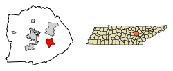
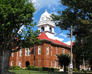
Cumberland County is a county located in the U.S. state of Tennessee. As of the 2020 census, the population was 61,145. Its county seat is Crossville. Cumberland County comprises the Crossville, TN micropolitan statistical area.

<span class="mw-page-title-main">Carter County, Tennessee</span> County in Tennessee, United States

Carter County is a county located in the U.S. state of Tennessee. As of the 2020 census, the population was 56,356. Its county seat is Elizabethton. The county is named in honor of Landon Carter (1760–1800), an early settler active in the "Lost State of Franklin" 1784-1788 secession from the State of North Carolina. Carter County is part of the Johnson City, TN Metropolitan Statistical Area, which is a component of the Johnson City–Kingsport–Bristol, TN-VA Combined Statistical Area, located in northeastern Tennessee.

<span class="mw-page-title-main">Crossville, Alabama</span> Town in Alabama, United States

Crossville is a town in DeKalb County, Alabama, United States. At the 2010 census the population was 1,862, up from 1,431 in 2000. Crossville is located atop Sand Mountain, a southern extension of the Cumberland Plateau.

<span class="mw-page-title-main">Pikeville, Tennessee</span> City in Tennessee, United States

Pikeville is a city in Bledsoe County, Tennessee. The population was 1,824 at the 2020 census. It is also the county seat of Bledsoe County.

<span class="mw-page-title-main">Charleston, Tennessee</span> City in Tennessee, United States

Charleston is a city in Bradley County, Tennessee, United States. The population was 664 at the 2020 census. It is included in the Cleveland Metropolitan Statistical Area.

<span class="mw-page-title-main">Cumberland Gap, Tennessee</span> Town in Claiborne County, Tennessee, United States

Cumberland Gap is a town in Claiborne County, Tennessee, United States. Its population was 494 at the 2010 census, and estimated to be 490 in 2019. The town is located below the Cumberland Gap, a historic mountain pass for which is the town's namesake, and inside of the boundaries of Cumberland Gap National Historical Park.

<span class="mw-page-title-main">Tazewell, Tennessee</span> Town in Tennessee, United States

Tazewell is a town in and the county seat of Claiborne County, Tennessee, United States. The population was 2,165 at the 2000 census, 2,218 at the 2010 census, and 2,348 at the 2020 census. The town is named for Tazewell, Virginia, which itself was named for Henry Tazewell (1753–1799), a U.S. senator from Virginia.

<span class="mw-page-title-main">Newport, Tennessee</span> City and county seat of Cocke County, Tennessee, United States

Newport is a city in and the county seat of Cocke County, Tennessee, United States. The population was 6,945 at the 2010 census, down from 7,242 at the 2000 census. The estimated population in 2018 was 6,801. Newport is located along the Pigeon River.

<span class="mw-page-title-main">Crossville, Tennessee</span> City in Tennessee, United States

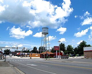
Crossville is a city in and the county seat of Cumberland County, Tennessee, United States. It is part of the Crossville Micropolitan Statistical Area. The population was 12,071 at the 2020 census.

<span class="mw-page-title-main">Pleasant Hill, Tennessee</span> Town in Tennessee, United States

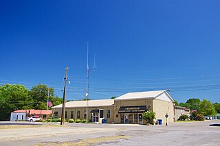
Pleasant Hill is a town in Cumberland County, Tennessee, United States. The population was 563 at the 2010 census.

<span class="mw-page-title-main">Jamestown, Tennessee</span> City in Tennessee, United States

Jamestown is a city in and the county seat of Fentress County, Tennessee, United States. The population of the city was 1,959 at the 2010 census.

<span class="mw-page-title-main">Athens, Tennessee</span> City in Tennessee, United States

Athens is the county seat of McMinn County, Tennessee, United States and the principal city of the Athens Micropolitan Statistical Area has a population of 53,569. The city is located almost equidistantly between the major cities of Knoxville and Chattanooga. The population was 14,084 at the 2020 census. The population of the zipcode area is at 23,726

<span class="mw-page-title-main">Wartburg, Tennessee</span> City in Tennessee, United States

Wartburg is a city in Morgan County, Tennessee, United States. The population was 918 at the 2010 census. It is the county seat of Morgan County.

<span class="mw-page-title-main">Monterey, Tennessee</span> Town in Tennessee, United States

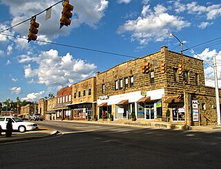
Monterey is a town in Putnam County, Tennessee, United States. The population was 2,850 at the 2010 census. It is part of the Cookeville, Tennessee Micropolitan Statistical Area.

<span class="mw-page-title-main">Pigeon Forge, Tennessee</span> City in Tennessee, United States

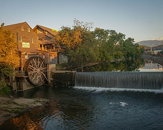
Pigeon Forge is a mountain resort city in Sevier County, Tennessee, United States. As of the 2020 census, the city had a total population of 6,343. Situated just 5 miles (8 km) north of Great Smoky Mountains National Park, Pigeon Forge is a tourist destination that caters primarily to Southern culture and country music fans. The city's attractions include Dollywood and Dollywood's Splash Country, WonderWorks, Alcatraz East Crime Museum, Dolly Parton's Stampede, as well as numerous gift shops, outlet malls, amusement rides, and musical theaters.

<span class="mw-page-title-main">Oliver Springs, Tennessee</span> Town in Tennessee, United States

Oliver Springs is a town in Anderson, Morgan, and Roane counties in the U.S. state of Tennessee. Its population was 3,231 at the 2010 census. It is included in the Harriman, Tennessee Micropolitan Statistical Area, which consists of Roane County.

<span class="mw-page-title-main">Cumberland Mountain State Park</span> State park in Tennessee, United States

Cumberland Mountain State Park is a state park in Cumberland County, Tennessee, in the southeastern United States. The park consists of 1,720 acres (7.0 km2) situated around Byrd Lake, a man-made lake created by the impoundment of Byrd Creek in the 1930s. The park is set amidst an environmental microcosm of the Cumberland Plateau and provides numerous recreational activities, including an 18-hole Bear Trace golf course.

<span class="mw-page-title-main">Ozone Falls State Natural Area</span>

Ozone Falls State Natural Area is a state natural area in Cumberland County, Tennessee in the southeastern United States. It consists of 43 acres (0.17 km2) centered on Ozone Falls, a 110-foot (34 m) plunge waterfall, and its immediate gorge along Fall Creek. Because of its picturesque beauty and easy access, Disney selected Ozone Falls for scenes for their live-action film "Rudyard Kipling's The Jungle Book". The area is managed by the Tennessee Department of Environment and Conservation and maintained by Cumberland Mountain State Park. It is also part of Cumberland Trail State Park.

References

  1. Entrance sign leading into the city.
  2. Tennessee Blue Book , 2005-2006, pp. 618-625.
  3. "ArcGIS REST Services Directory". United States Census Bureau. Retrieved October 15, 2022.
  4. 1 2 U.S. Geological Survey Geographic Names Information System: Crab Orchard, Tennessee
  5. 1 2 "Census Population API". United States Census Bureau. Retrieved October 15, 2022.
  6. 1 2 "U.S. Census website". United States Census Bureau . Retrieved January 31, 2008.
  7. Tennessee Department of Economic and Community Development, Certified Population of Tennessee Incorporated Municipalities and Counties Archived June 30, 2014, at the Wayback Machine , State of Tennessee official website, July 14, 2011. Retrieved: December 6, 2013.
  8. Helen Bullard and Joseph Krechniak, Cumberland County's First Hundred Years (Crossville, Tenn.: Centennial Committee, 1956), 122.
  9. J.G.M. Ramsey, The Annals of Tennessee (Johnson City, Tennessee: Tennessee Overmountain Press, 1999), 500-501.
  10. Ramsey, Annals of Tennessee, 571-572.
  11. Ramsey, The Annals of Tennessee, 591-595.
  12. Michael Boniol, "Cumberland County History," 2003. Retrieved: January 2, 2008.
  13. Bullard and Krechniak, Cumberland County's First Hundred Years, 21, 122.
  14. Carroll Van West, "Crab Orchard Stone." The Tennessee Encyclopedia of History and Culture, 2002. Retrieved: January 2, 2008.
  15. "US Gazetteer files: 2010, 2000, and 1990". United States Census Bureau. February 12, 2011. Retrieved April 23, 2011.
  16. Climate Summary for Crab Orchard, Tennessee
  17. "Census of Population and Housing: Decennial Censuses". United States Census Bureau . Retrieved March 4, 2012.
  18. "Incorporated Places and Minor Civil Divisions Datasets: Subcounty Resident Population Estimates: April 1, 2010 to July 1, 2012". Population Estimates. U.S. Census Bureau. Archived from the original on June 11, 2013. Retrieved December 11, 2013.
  19. "Explore Census Data". data.census.gov. Retrieved December 27, 2021.