
Cumberland County is a county located in the U.S. state of Tennessee. As of the 2020 census, the population was 61,145. Its county seat is Crossville. Cumberland County comprises the Crossville, TN micropolitan statistical area.

Crab Orchard is a city in Cumberland County, Tennessee, United States. The population was 719 at the 2020 census.

Crossville is a city in and the county seat of Cumberland County, Tennessee, United States. It is part of the Crossville Micropolitan Statistical Area. The population was 12,071 at the 2020 census.
The Falling Water River is a 46.8-mile-long (75.3 km) stream in the east-central portion of Middle Tennessee in the United States. It rises just west of Monterey at the edge of the Cumberland Plateau, and traverses the Eastern Highland Rim before dropping off to the Nashville Basin and emptying into Center Hill Lake along the Caney Fork. The river is noted for the 136-foot (41 m) Burgess Falls, which it spills over near the end of its course.

The Big South Fork of the Cumberland River is a 76-mile-long (122 km) river in the U.S. states of Tennessee and Kentucky. It is a major drainage feature of the Cumberland Plateau, a major tributary of the Cumberland River system, and the major feature of the Big South Fork National River and Recreation Area.
The Little Obed River is a ten mile long stream in the Cumberland Plateau in Cumberland County, Tennessee.

Obed River is a stream draining a part of the Cumberland Plateau in Tennessee. It, and particularly its tributaries, are important streams for whitewater enthusiasts.

Myles Falls Horton was an American educator, socialist, and co-founder of the Highlander Folk School, famous for its role in the Civil Rights Movement. Horton taught and heavily influenced most of the era's leaders. They included Martin Luther King Jr., Rosa Parks, John Lewis, James Bevel, Bernard Lafayette, and others who would create the Nashville Student Movement, Ralph Abernathy, John B. Thompson, and many others.

Fall Creek Falls State Resort Park is a state park in Van Buren and Bledsoe counties, in the U.S. state of Tennessee. The over 30,638-acre (123.99 km2) park is centered on the upper Cane Creek Gorge, an area known for its unique geological formations and scenic waterfalls. The park's namesake is the 256-foot (78 m) Fall Creek Falls, the highest free-fall waterfall east of the Mississippi River.

The Crab Orchard Mountains are a rugged, detached range of the southern Cumberland Mountains. They are situated in East Tennessee atop the Cumberland Plateau just west of the plateau's eastern escarpment, and comprise parts of Morgan, Anderson, and Cumberland counties. The Crab Orchard Mountains have many peaks over 3,000 ft., with the highest being Big Fodderstack at 3,340 feet (1,020 m) and Frozen Head at 3,324 feet (1,013 m), the latter and part of the former being located in Frozen Head State Park. The mountains are made rugged by the erosion of many streams that have cut deep gorges into the mountains. The Crab Orchard Mountains are still one of the most rural areas in all of Appalachia. The historic Brushy Mountain State Penitentiary is located at the base of Frozen Head in Petros, bounded on the north and west by Frozen Head State Park.

Rock Island State Park is a state park in Warren County and White County, Tennessee, located in the Southeastern United States. The park is named after the community of Rock Island, Tennessee, which in turn received its name from an island on the Caney Fork upstream from the Collins River confluence and Great Falls Dam. Rock Island State Park is centered on a peninsula created by the confluence of these two rivers and extends downstream to the headwaters of Center Hill Lake.

Cumberland Mountain State Park is a state park in Cumberland County, Tennessee, in the southeastern United States. The park consists of 1,720 acres (7.0 km2) situated around Byrd Lake, a man-made lake created by the impoundment of Byrd Creek in the 1930s. The park is set amidst an environmental microcosm of the Cumberland Plateau and provides numerous recreational activities, including an 18-hole Bear Trace golf course.

The Old Stone Fort is a prehistoric Native American structure located in Coffee County, Tennessee, in the Southeastern United States. The structure was most likely built between 80 and 550 AD during the Middle Woodland period. It is the most complex hilltop enclosure found in the South and was likely used for ceremonial purposes rather than defense.

Scott's Gulf is a canyon situated along the Caney Fork River in White County, Tennessee, in the southeastern United States. The canyon stretches for approximately 18 miles (29 km) as the Caney Fork drops from the top of the Cumberland Plateau down to the eastern Highland Rim. This remote section of the river is home to a wilderness area consisting of a largely undisturbed deciduous forest, numerous waterfalls, caves and other geological formations, and Class IV and Class V whitewater rapids.

Ozone Falls State Natural Area is a state natural area in Cumberland County, Tennessee in the southeastern United States. It consists of 43 acres (0.17 km2) centered on Ozone Falls, a 110-foot (34 m) plunge waterfall, and its immediate gorge along Fall Creek. Because of its picturesque beauty and easy access, Disney selected Ozone Falls for scenes for their live-action film "Rudyard Kipling's The Jungle Book". The area is managed by the Tennessee Department of Environment and Conservation and maintained by Cumberland Mountain State Park. It is also part of Cumberland Trail State Park.

Pocket wilderness is a name used by Bowater corporation and the State of Tennessee for any of several tracts of Bowater-owned private land on and near the Cumberland Plateau that the company set aside beginning in 1970 "for preservation in its natural state, with no logging or development other than hiking trails permitted within its boundaries" and registered as Tennessee state natural areas. Several areas formerly managed as Bowater pocket wilderness are now incorporated into state-owned natural areas or National Park Service sites.

Grassy Cove is an enclosed valley in Cumberland County, Tennessee, United States. The valley is notable for its karst formations, which have been designated a National Natural Landmark. Grassy Cove is also home to a small unincorporated community.
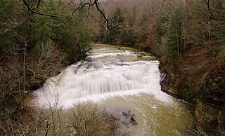
Ozone Falls is a waterfall located in Cumberland County, Tennessee in the Ozone Falls State Natural Area and Cumberland Trail State Park. Ozone Falls is situated along Fall Creek, which drains a short section of the Cumberland Plateau between the Crab Orchard Mountains to the west and Walden Ridge to the east. The creek flows down from its source high in the Crab Orchard Mountains for a mile or so before steadying briefly as it enters the community of Ozone. Fall Creek enters the state natural area just after it passes under U.S. Route 70, which runs perpendicular to it. The creek spills over Ozone Falls a few hundred meters south of US-70. The trailhead is located along US-70.

State Route 30 is an east-west state highway in the central and eastern portions of the U.S. state of Tennessee. It runs generally west to east, connecting McMinnville in Warren County with Parksville along the Ocoee River in Polk County. It crosses several major geographic features in Tennessee, including the Cumberland Plateau, the Sequatchie Valley, the Tennessee River, and parts of the Cherokee National Forest.


