Crane, Missouri | |
---|---|
![]() Location of Crane, Missouri | |
Coordinates: 36°54′19″N93°34′18″W / 36.90528°N 93.57167°W [1] | |
Country | United States |
State | Missouri |
County | Stone |
Government | |
• Type | Mayor/Council |
• Mayor | C. Brannen |
Area | |
• Total | 1.52 sq mi (3.95 km2) |
• Land | 1.52 sq mi (3.94 km2) |
• Water | 0.00 sq mi (0.01 km2) |
Elevation | 1,145 ft (349 m) |
Population (2020) | |
• Total | 1,495 |
• Density | 983.55/sq mi (379.64/km2) |
Time zone | UTC-6 (Central (CST)) |
• Summer (DST) | UTC-5 (CDT) |
ZIP code | 65633 |
Area code | 417 |
FIPS code | 29-17074 [3] |
Website | http://www.crane-mo.com/ |
Crane (formerly Hickory Grove) [4] is a town in Stone County, Missouri, United States. The population was 1,495 at the 2020 census. [5] It is part of the Branson, Missouri Micropolitan Statistical Area.
Crane was platted in 1895, taking its name from nearby Crane Creek. [6] A post office called Crane has been in operation since 1887. [7]
The town is in northwest Stone County, approximately four miles northwest of Elsey along Missouri Route 173, and eleven miles south of Billings, in Christian County. Crane Creek flows through the town. [8]
According to the United States Census Bureau, the city has a total area of 1.52 square miles (3.94 km2), all land. [9]
Census | Pop. | Note | %± |
---|---|---|---|
1910 | 1,002 | — | |
1920 | 1,151 | 14.9% | |
1930 | 1,030 | −10.5% | |
1940 | 1,013 | −1.7% | |
1950 | 939 | −7.3% | |
1960 | 954 | 1.6% | |
1970 | 1,003 | 5.1% | |
1980 | 1,185 | 18.1% | |
1990 | 1,218 | 2.8% | |
2000 | 1,390 | 14.1% | |
2010 | 1,462 | 5.2% | |
2020 | 1,495 | 2.3% | |
U.S. Decennial Census |
As of the census [10] of 2010, there were 1,462 people, 558 households, and 347 families living in the city. The population density was 961.8 inhabitants per square mile (371.4/km2). There were 663 housing units at an average density of 436.2 per square mile (168.4/km2). The racial makeup of the city was 97.2% White, 0.1% African American, 0.7% Native American, 0.2% Asian, 0.4% from other races, and 1.4% from two or more races. Hispanic or Latino of any race were 1.2% of the population.
There were 558 households, of which 35.1% had children under the age of 18 living with them, 44.6% were married couples living together, 13.3% had a female householder with no husband present, 4.3% had a male householder with no wife present, and 37.8% were non-families. 33.7% of all households were made up of individuals, and 21.5% had someone living alone who was 65 years of age or older. The average household size was 2.43 and the average family size was 3.12.
The median age in the city was 39.9 years. 25.1% of residents were under the age of 18; 7.1% were between the ages of 18 and 24; 24.2% were from 25 to 44; 22.1% were from 45 to 64; and 21.5% were 65 years of age or older. The gender makeup of the city was 46.6% male and 53.4% female.
As of the census [10] of 2000, there were 1,390 people, 541 households, and 333 families living in the city. The population density was 944.9 inhabitants per square mile (364.8/km2). There were 630 housing units at an average density of 428.3 per square mile (165.4/km2). The racial makeup of the city was 96.62% White, 0.07% African American, 0.36% Native American, 0.07% Asian, 0.07% from other races, and 2.81% from two or more races. Hispanic or Latino of any race were 0.86% of the population.
There were 541 households, out of which 32.2% had children under the age of 18 living with them, 47.0% were married couples living together, 10.7% had a female householder with no husband present, and 38.4% were non-families. 35.7% of all households were made up of individuals, and 23.7% had someone living alone who was 65 years of age or older. The average household size was 2.41 and the average family size was 3.15.
In the city the population was spread out, with 26.7% under the age of 18, 9.1% from 18 to 24, 24.3% from 25 to 44, 18.6% from 45 to 64, and 21.4% who were 65 years of age or older. The median age was 37 years. For every 100 females, there were 87.1 males. For every 100 females age 18 and over, there were 81.3 males.
The median income for a household in the city was $20,848, and the median income for a family was $31,806. Males had a median income of $26,583 versus $18,750 for females. The per capita income for the city was $12,120. About 15.2% of families and 20.8% of the population were below the poverty line, including 21.3% of those under age 18 and 28.0% of those age 65 or over.
Crane R-III School District operates one elementary school, one middle school, and Crane High School. [11] Crane High School has a variety of athletic activities for students, including Archery, Baseball, Cheerleading, Basketball, Softball, Trap, and Volleyball. [12]
Crane has a public library, a branch of the Stone County Library. [13]
New Florence is a city in Montgomery County, Missouri, United States. The population was 641 at the 2020 census.
Cooter is a city in Pemiscot County, Missouri, United States. The population was 343 at the 2020 census.
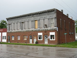
Smithton is a city in Pettis County, Missouri, United States. The population was 570 at the 2010 census.
Lake Waukomis is a city in Platte County, Missouri and is part of the Kansas City metropolitan area within the United States. The population was 888 at the 2020 census.
Pleasant Hope is a city in Polk County, Missouri, United States. The population was 614 at the 2010 census. It is part of the Springfield, Missouri Metropolitan Statistical Area.
Bella Villa is a city in St. Louis County, Missouri, in the United States. As of the 2010 census, the city population was 729.
Country Club Hills is a city in St. Louis County, Missouri, United States. The population was 1,274 at the 2010 census.
Crystal Lake Park is a Missouri Class 4 city in St. Louis County, Missouri, United States. The population was 508 at the 2020 census.
Dellwood is a city in the north St. Louis County, Missouri, United States. The population was 5,025 at the 2010 census. The center of Dellwood or the city of Dellwood was located at the intersections of West Florissant Ave. and Chambers Road.
Northwoods is a city in St. Louis County, Missouri, United States. The population was 4,227 at the 2010 census.
Oakland is a city in St. Louis County, Missouri, United States. The population was 1,381 at the 2010 census.
Pasadena Hills is a city in St. Louis County, Missouri, United States. The population was 930 at the 2010 census. The entire city is listed on the National Register of Historic Places.
Velda City is a city in St. Louis County, Missouri, United States. The population was 1,420 at the 2010 census.
Winchester is a city in St. Louis County, Missouri, United States. The population was 1,447 at the 2020 census.
Woodson Terrace is a city in St. Louis County, Missouri, United States. The population was 4,063 at the 2010 census.
Galena is a city in Stone County, Missouri, United States. The population was 455 at the 2020 census. It is the county seat of Stone County. Galena is part of the Branson, Missouri Micropolitan Statistical Area.
Hurley is a city in Stone County, Missouri, United States. The population was 176 at the 2020 census. It is part of the Branson, Missouri Micropolitan Statistical Area.
Kimberling City is a city in Stone County, Missouri, United States. The population was 2,344 at the 2020 census.
Clarkson Valley is a city in St. Louis County, Missouri, United States. The population was 2,609 at the 2020 census.
Moline Acres is a city in St. Louis County, Missouri, United States. The population was 2,442 at the 2010 census.