Cumberland Estates

Last updated
Cumberland Estates
House that home built.jpg
NBC's The House That HOME Built (4116 Royalview Road), built in 1957
TNMap-doton-Knoxville.PNG
Location in the State of Tennessee
Usa edcp location map.svg
Red pog.svg
Cumberland Estates
Location in the United States
Coordinates: 35°59′02″N84°00′45″W / 35.98389°N 84.01250°W / 35.98389; -84.01250 [1]
CountryUnited States
State Tennessee
County Knox
City Knoxville
Developed1955-1965
DeveloperBradley Dean
Architect Bruce McCarty, and others
Architectural style Mid-century Modern
Time zone UTC−05:00 (EST)
  Summer (DST) UTC−04:00 (EDT)
Area code 865
Zip Code37921

Cumberland Estates is a residential neighborhood in the City of Knoxville, Tennessee, United States, which gained national attention for architectural innovation and research housing in the mid-20th century. It began 2.1 miles outside the city limits, in Knox County, as one of many planned suburban neighborhoods in the post-World War II economic expansion. The development soon attracted an innovative young architect and national sponsors who would create new ways to rapidly and affordably fill the demand for residential housing needs for America’s growing population of families. Their prominent work in the neighborhood influenced the evolution of residential building design. While the attention received from the research homes waned in the last century, the neighborhood has maintained its residential character with few changes while avoiding commercial encroachment and blight.

Contents

Location

It is located seven miles northwest of downtown Knoxville and lies in the eastern portion of Tennessee in the foothills of the Appalachian Mountains. The neighborhood is bordered to the east by Victor Ashe Park and West Haven, to the north by Norwood, to the west by Karns, and to the south by West Hills. Third Creek runs through the neighborhood before emptying into the Tennessee River at the University of Tennessee. The City of Oak Ridge is 14 miles to the west on State Route 62, known locally as Oak Ridge Highway, where many of the neighborhood's first residents worked in the national facilities succeeding the Manhattan Project. [2]

Post-war development

Cumberland Estates was developed by Bradley Dean in 16 sections during a period of 10 years with the first section recorded at the Knox County Register of Deeds on November 7, 1955, by Dean, President of East Tennessee Development Co., and the final section recorded November 23, 1965, by Dean, at this time president of Dean & Company Inc. The 16 sections were all titled “Cumberland Estates.” The first 13 sections were developed on the north side of Oak Ridge Highway, while the final three were developed south of Oak Ridge Highway. The 16 sections - numbered 1 through 17 while skipping number 13 - each have a Declaration of Restrictions, governing 16 detailed points such as setbacks, minimum square footage, and other building restrictions common to planned suburban neighborhoods. [3]

The development began along Sullivan Road, and was followed with the creation of some 25 miles of new streets. One of these, Palmetto, connects Sullivan Road to Oak Ridge Highway, which, on the plats filed at the Knoxville City-County Building, is often referred to as “Solway Road” or “Solway Highway to Oak Ridge.” [3] [4]

Near its completion, Dean was named the 1965 Tennessee Home Builder of the Year, and in 1966 he became president of the Home Builders Association of Greater Knoxville. [5] [6]

Feature television and research housing

Two of the homes influenced the post-World War II architectural trends and construction methods. They were designed by architect Bruce McCarty, whose designs represented the most advanced modernist theories applying manufacturing technology to housing design and received national attention and promotions by the National Broadcasting Company and the National Association of Homebuilders. [7]

The House That HOME Built

In 1957, the producers of the NBC television show HOME commissioned McCarty to design a home which would introduce homemakers to the latest in design. The morning magazine show sponsored innovative house projects in a feature titled “The House That HOME Built.” McCarty and his wife, Elizabeth, appeared on the program with its host, Arlene Francis, and co-host, Hugh Downs, in its New York studio to discuss this particular house design as well as housing needs expressed by young families. [8] [9] [10]

The house was based on the planning principles agreed to by the 1956 Women’s Congress on Housing, organized by the U.S. Housing and Home Finance Agency. The celebrated promotion captured the attention and cooperation of the home builders in the area in a unique venture. The members of the Home Builders Association of Greater Knoxville agreed in July 1957 that all the builders participating in the 1957 Parade of Homes should combine efforts in building the McCarty-designed home. It was the first such cooperative venture ever initiated. [10] [11]

The house, built at 4116 Royalview Road, was originally owned by Martin L. Bartling Jr, a creative home builder whose houses became nationally recognized. He was president of the National Association of Home Builders in the late 1960s. [12] [13]

The first family to live in the house was Loyd and Frances Wilson and their sons, Jeff and Eric, from 1957 to 1964. [14]

One of the last remaining original home owners still living in Cumberland Estates died in December 2018. Ms. Dolores and her husband James (d. 2000) were the first and only owners of their home on Robindale Drive (an 1800 square foot three-bedroom basement rancher), which they purchased in 1962 for approximately $18,000, on the north side of Cumberland Estates.

1959 NAHB research house

As the post-war high demand for housing created the need for a more affordable and swifter type of construction, the National Association of Home Builders commissioned McCarty to design a research house in 1959. It was titled “A house for you from America’s homebuilding industry” and was built at 4409 Crestfield Road. [15]

McCarty’s concentration was in breaking down all of the building elements into modular parts that could be prefabricated and organized into well-planned medium-cost housing. These elements included wall panels, closet hardware, kitchen-bathroom cores, and window units. The wall construction design was an interlocking prefabricated wall-panel system consisting of a pre-finished interior skin, electrical wiring and insulation, with the modular panels made by the builder off site which could then all be snapped into place at one time. It was considered one of the most adaptable ideas from the research house. [12] [16]

Innovative utility-saving features included an electronic toilet using one gallon of water per flush as compared to the usual five, faucet controls reducing water consumption, and full-height room doors eliminating high wall areas that prevent recirculation of central heat and air at ceiling level. Every interior and exterior detail was designed for efficiency and reducing costs, including decorative details which were designed as structural components. [16]

Home styles

Houses in Cumberland Estates consist primarily of ranch, basement ranch and split-level homes positioned in the neighborhood hills typical of East Tennessee topography. Home designs are largely consistent with the mid-century modern design movement. McCarty’s residential designs were influenced by architect Frank Lloyd Wright. House sizes generally range between 1,000 and 2,000 square feet, with lots in size from approximately 1/4 acre to 1/2 acre. [3] [17]

Recreation and parks

Dean included three swimming pools in the development and set aside a 26-acre wooded lot for the creation of the Cumberland Estates Recreation Center, a city-owned facility with meeting rooms, gym, dance studio, outdoor playground and nature trails. It is commonly used for children and senior activities and neighborhood and community meetings. [18]

Bordering Cumberland Estates to the east lies Victor Ashe Park, a 120 acre city park of recreational fields, greenway, dog parks, disc golf, restrooms, playground, and a pond. The neighborhood and park are connected by Third Creek, which Dean partially relocated in 1960 to develop section seven between Sullivan and Deerfield Roads. [19] [20]

City annexation

The Cumberland Estates development began 2.1 miles from the city limits. Before it was completed, the Knoxville City Council voted to annex it, as well as other suburban neighborhoods, on Tuesday November 22, 1960, increasing the city’s population by an estimated 70,000 to 181,000, and increasing the overall area of the city from 26.5 square miles to 81 square miles. [4]

The reported population of Cumberland Estates at the time of annexation was 3,050 in 919 dwelling units, and the still developing neighborhood encompassed 3.5 square miles, or approximately 2,240 acres, with 25 miles of streets. [4]

In preparation for the annexation, Knoxville Fire Department Chief Roy Conner announced a proposed new fire station to be located at Oak Ridge Highway and Third Creek. [21]

City Council voted in January 1980 to change the name of Oak Ridge Highway to Western Avenue from Pleasant Ridge Road out to the city limits, becoming the first street name change within the neighborhood. [22]

To maintain a residential flavor along Western Avenue, the Metropolitan Planning Commission adopted a land use plan in 1970 recommending future commercial activity along the highway to be limited to community shopping facilities within and around the Cumberland Estates Shopping Center and single occupant commercial offices along the highway between Ball Camp Pike and Hinton Road. [23]

Related Research Articles

<span class="mw-page-title-main">Knox County, Tennessee</span> County in Tennessee, United States

Knox County is located in the U.S. state of Tennessee. As of the 2020 census, the population was 478,971, making it the third-most populous county in Tennessee. Its county seat is Knoxville, which is the third-most populous city in Tennessee. Knox County is included in the Knoxville metropolitan area. The county is located at the geographical center of the Great Valley of East Tennessee. Near the heart of the county is the origin of the Tennessee River, at the confluence of the Holston and French Broad rivers.

<span class="mw-page-title-main">Knoxville, Tennessee</span> City in Tennessee, United States

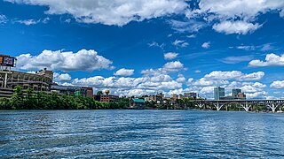
Knoxville is a city in and the county seat of Knox County, Tennessee, United States. As of the 2020 United States census, Knoxville's population was 190,740, making it the largest city in the East Tennessee Grand Division and the state's third largest city after Nashville and Memphis. It is the principal city of the Knoxville metropolitan area, which had a population of 879,773 in 2020.

<span class="mw-page-title-main">Tennessee Valley</span> Drainage basin of the Tennessee River

The Tennessee Valley is the drainage basin of the Tennessee River and is largely within the U.S. state of Tennessee. It stretches from southwest Kentucky to north Alabama and from northeast Mississippi to the mountains of Virginia and North Carolina. The border of the valley is known as the Tennessee Valley Divide. The Tennessee Valley contributes greatly to the formation of Tennessee's three legally recognized sectors.

<span class="mw-page-title-main">Powell, Tennessee</span> CDP in Tennessee, United States

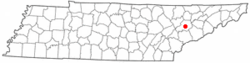
Powell, formerly known as Powell Station, is a census-designated place in Knox County, Tennessee. The area is located in the Emory Road corridor, just north of Knoxville, southeast of Clinton, and east of Oak Ridge. It had a population of 13,802 during the 2020 census. It is included in the Knoxville, TN Metropolitan Statistical Area.

<span class="mw-page-title-main">Mechanicsville, Knoxville</span> United States historic place

Mechanicsville is a neighborhood in Knoxville, Tennessee, United States, located northwest of the city's downtown area. One of the city's oldest neighborhoods, Mechanicsville was established in the late 1860s for skilled laborers working in the many factories that sprang up along Knoxville's periphery. The neighborhood still contains a significant number of late-19th-century Victorian homes, and a notable concentration of early-20th-century shotgun houses. In 1980, several dozen properties in Mechanicsville were added to the National Register of Historic Places as the Mechanicsville Historic District. The neighborhood was also designated as a local historic district in 1991, subject to historic zoning and design standards.

<span class="mw-page-title-main">Sequoyah Hills</span> Neighborhood of Knoxville, Tennessee, United States

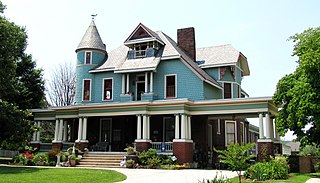
Sequoyah Hills is a neighborhood in Knoxville, Tennessee, United States, named for the Cherokee scholar Sequoyah, inventor of the Cherokee alphabet. It is located off Kingston Pike, between the city's downtown and West Knoxville. Initially developed in the 1920s, Sequoyah Hills was one of Knoxville's first suburbs and today is home to some of the city's most affluent residents. The neighborhood contains numerous notable examples of mid-20th century residential architecture, with houses designed by architects such as Charles I. Barber, Benjamin McMurry, and Francis Keally.

<span class="mw-page-title-main">U.S. Route 25E</span> Highway in Tennessee and Kentucky, United States

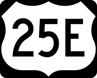
U.S. Route 25E (US 25E) is the eastern branch of US 25 from Newport, Tennessee, where US 25 splits into US 25E and US 25W, to North Corbin, Kentucky, where the two highways rejoin. The highway, however, continues as US 25E for roughly two miles (3.2 km) until it joins Interstate 75 (I-75) in the Laurel County community of North Corbin at exit 29. The highway serves the Appalachia regions of Kentucky's Cumberland Plateau and the Ridge-and-Valley section of East Tennessee, including the urbanized areas of Corbin and Middlesboro in Kentucky and Morristown in Tennessee.

<span class="mw-page-title-main">Sharp's Ridge</span> Geologic feature in Knoxville, Tennessee

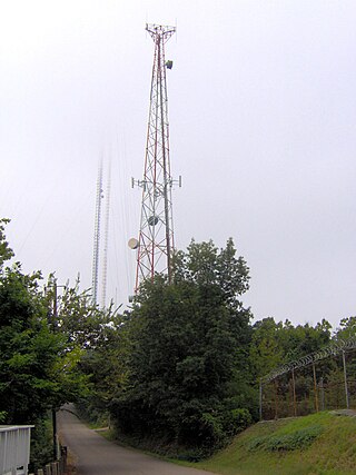
Sharp's Ridge is a steep ridge in Knoxville, Tennessee, north of the city's downtown. A 111-acre (45 ha) area of the 7-mile (11 km) ridge is maintained as Sharp's Ridge Memorial Park, a city park dedicated to the honor of the area's war veterans. The ridge also is the site of a transmitting antenna farm that serves most of Knoxville's broadcasters. The highest ground point on the ridge is an abandoned fire tower located at 1,391 feet (424 m) above mean sea level. The ridge itself averages 200 to 300 feet above the surrounding valley floor, allowing panoramic views of the Great Smoky Mountains and adjacent ranges to the east and the Cumberland Plateau and Cumberland Mountains to the west.

<span class="mw-page-title-main">Kingston Pike</span> United States historic place

Kingston Pike is a highway in Knox County, Tennessee, United States, that connects Downtown Knoxville with West Knoxville, Farragut, and other communities in the western part of the county. The road follows a merged stretch of U.S. Route 11 (US 11) and US 70. From its initial construction in the 1790s until the development of the Interstate Highway System in the 1960s, Kingston Pike was the main traffic artery in western Knox County, and an important section of several cross-country highways. The road is now a major commercial corridor, containing hundreds of stores, restaurants, and other retail establishments.

<span class="mw-page-title-main">Interstate 40 in Tennessee</span> Interstate Highway in Tennessee, United States

Interstate 40 (I-40) is part of the Interstate Highway System that runs 2,556.61 miles (4,114.46 km) from Barstow, California, to Wilmington, North Carolina. The highway crosses Tennessee from west to east, from the Mississippi River at the Arkansas border to the Blue Ridge Mountains at the North Carolina border. At 455.28 miles (732.70 km), the Tennessee segment of I-40 is the longest of the eight states through which it passes and the state's longest Interstate Highway.

<span class="mw-page-title-main">Interstate 75 in Tennessee</span> Highway in Tennessee

Interstate 75 (I-75) in the US state of Tennessee runs from Chattanooga to Jellico by way of Knoxville. I-75 enters the East Tennessee region from Georgia, following the Tennessee Valley all the way through Knoxville to near Rocky Top, then climbs into the Cumberland Mountains before crossing over into Kentucky at Jellico.

Bruce McCarty, FAIA was an American architect, founder and senior designer at McCarty Holsaple McCarty Architects of Knoxville, Tennessee. During a career that has spanned more than a half-century, he designed some of the city's iconic landmarks, and was the city's most dedicated champion of Modern architecture. Buildings designed or co-designed by McCarty include the Lawson McGhee Library, Knoxville City County Building, University of Tennessee Humanities Complex, Clarence Brown Theatre, and University of Tennessee Art and Architecture Building. McCarty was also the Master Architect for the 1982 World's Fair.

<span class="mw-page-title-main">Old North Knoxville</span> Neighborhood in Knoxville, Tennessee, United States

Old North Knoxville is a neighborhood in Knoxville, Tennessee, United States, located just north of the city's downtown area. Initially established as the town of North Knoxville in 1889, the area was a prominent suburb for Knoxville's upper middle and professional classes until the 1950s. After a period of decline, preservationists began restoring many of the neighborhood's houses in the 1980s. In 1992, over 400 houses and secondary structures in the neighborhood were added to the National Register of Historic Places as the Old North Knoxville Historic District.

North Knoxville is the section of Knoxville, Tennessee, USA, that lies north of the city's downtown area. It is concentrated around Broadway (US-441), Clinton Highway (US-25W), Tazewell Pike (TN-331), Washington Pike, and adjacent roads, and includes the neighborhoods of Fountain City, Inskip-Norwood, Oakwood-Lincoln Park, Old North Knoxville, Fourth and Gill, North Hills, and Whittle Springs. North Knoxville is bisected by Sharp's Ridge, a 7-mile (11 km) elongate ridge that rises prominently above the surrounding terrain.

<span class="mw-page-title-main">Fort Sanders, Knoxville</span> United States historic place

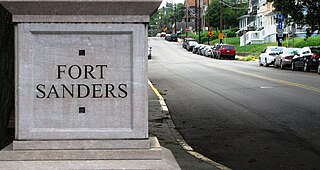
Fort Sanders is a neighborhood in Knoxville, Tennessee, USA, located west of the downtown area and immediately north of the main campus of the University of Tennessee. Developed in the late 19th century as a residential area for Knoxville's growing upper and middle classes, the neighborhood now provides housing primarily for the university's student population. The neighborhood still contains a notable number of its original Victorian-era houses and other buildings, several hundred of which were added to the National Register of Historic Places in 1980 as the Fort Sanders Historic District.

<span class="mw-page-title-main">Fourth and Gill, Knoxville</span> Historic house in Tennessee, United States

Fourth and Gill is a neighborhood in Knoxville, Tennessee, United States, located north of the city's downtown area. Initially developed in the late nineteenth century as a residential area for Knoxville's growing middle and professional classes, the neighborhood still contains most of its original Victorian-era houses, churches, and streetscapes. In 1985, 282 houses and other buildings in the neighborhood were added to the National Register of Historic Places as the Fourth and Gill Historic District.

<span class="mw-page-title-main">Lindbergh Forest</span> Historic house in Tennessee, United States

Lindbergh Forest is a neighborhood in Knoxville, Tennessee, United States, located off Chapman Highway (US-441) in South Knoxville, that is listed on the National Register of Historic Places as an historic district. Initially developed in the late 1920s as one of Knoxville's first automobile suburbs, the neighborhood is now noted for its late-1920s and early-1930s residential architecture, and the use of East Tennessee marble detailing. The neighborhood also contains two of Knoxville's five surviving Lustron houses. In 1998, several of its houses were added to the National Register of Historic Places as the Lindbergh Forest Historic District.

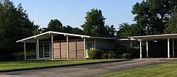
West Hills is a neighborhood in Knoxville, Tennessee, United States, located just off Kingston Pike in West Knoxville. Initially developed in the 1950s, West Hills was Knoxville's first major post-World War II subdivision, and the first subdivision to consist primarily of modern ranch-style houses. While West Knoxville experienced a boom in commercial development in the 1970s and 1980s, West Hills has managed to retain its residential character, due in large part to its aggressive neighborhood advocacy group, the West Hills Community Association.

Thomas Hope was an English-born American architect and house joiner, active primarily in Knoxville, Tennessee, during the late eighteenth and early nineteenth centuries. Trained in London, Hope moved to Knoxville in 1795, where he designed and built several of the city's earliest houses. At least two houses built by Hope— the Ramsey House (1797) in East Knoxville and Statesview in West Knoxville— are still standing, and have been listed on the National Register of Historic Places.

<span class="mw-page-title-main">Ed Westcott</span> American photographer (1922–2019)

James Edward Westcott was an American photographer who was noted for his work with the United States government in Oak Ridge, Tennessee, during the Manhattan Project and the Cold War.

References

  1. U.S. Geological Survey Geographic Names Information System: Cumberland Estates
  2. Miller, Mike (8-18-1961). The Knoxville News-Sentinel. p C-8.
  3. 1 2 3 Legal Record Cumberland Estates plats filed by Bradley Dean, Knox County, Tennessee; Section 1, 11/7/1955, Book 22, page 79; Section 2, 2/4/1956, Book 22, page 114; Section 3, 10/8/1956, Book 23, page 48; Section 4, 3/19/1957, Book 23, page 51; Section 5, 3/3/1959, Book 24, page 117; Section 6 3/19/1957, Book 23, page 82; Section 7, 2/19/1960, Book 25, page 142; Section 8, 3/20/1958, Book 24, page 31; Section 9, 4/18/1960, Book 26, page 10; Section 10, 4/18/1960, Book 26, page 11; Section 11, 9/27/1960, Book 26, page 200; Section 12, 6/6/1961, Book 27, page 111; Section 14, 5/24/1962, Book 31, page 26; Section 15, 6/21/1962, Book 31, page 81; Section 16, 8/14/1964, Book 38.5, page 52; Section 17, 11/23/1965, Book 42.5, page 41.
  4. 1 2 3 "Here Are New Parts of City, Cumberland Estates." 11/27/1960. p. F-8. The Knoxville News-Sentinel.
  5. "Builders Honor Dean." 7/15/1966. The Knoxville Journal.
  6. "Past Presidents of the Home Builders Association of Greater Knoxville". Home Builders Association of Greater Knoxville. 2010. Archived from the original on 2015-05-12. Retrieved 2015-06-19.
  7. Yates, Sam, "Selected Projects: The Architecture of Bruce McCarty," pgs. 9,16, Ewing Gallery, The University of Tennessee, 2004.
  8. "Knoxville Modernism and Architect Bruce McCarty". Neely, Jack (3-17-2010). Metropulse. 2010. Retrieved 2015-06-20.[ permanent dead link ]
  9. Yates, Sam, "Selected Projects: The Architecture of Bruce McCarty," p. 16, Ewing Gallery, The University of Tennessee, 2004.
  10. 1 2 Cunningham, Bob (7-14-1957). " 'Parade' Contractors To Build Model Home." The Knoxville News-Sentinel.
  11. "The House That Home Built," March 11–22, 1957, HOME in review . . ., Vol 2, No 6, Program Edition 784-793.
  12. 1 2 Yates, Sam, "Selected Projects: The Architecture of Bruce McCarty," p. 22, Ewing Gallery, The University of Tennessee, 2004.
  13. Legal Document Warranty Deed between Cumberland Estates, Inc. and Martin L. Bartling Jr. and wife Catherine H. Bartling, Knox County, Tennessee, Book 1049, page 205.
  14. Personal account of the year Jeff Wilson
  15. Yates, Sam, "Selected Projects: The Architecture of Bruce McCarty," pgs. 9,16,23, Ewing Gallery, The University of Tennessee, 2004.
  16. 1 2 "Tomorrow's Houses-Today. NAHB's Two Research Houses Are Unveiled," January 1959, NAHB JOURNAL of homebuilding, pgs. 39-49, 98.
  17. Yates, Sam, "Selected Projects: The Architecture of Bruce McCarty," p. 21, Ewing Gallery, The University of Tennessee, 2004.
  18. "Cumberland Estates Recreation Center". City of Knoxville. 2014. Archived from the original on 2005-05-26. Retrieved 2015-06-20.
  19. "Victor Ashe Park". City of Knoxville. 2014. Archived from the original on 2008-09-23. Retrieved 2015-06-20.
  20. Legal Record Cumberland Estates plat filed by Bradley Dean, Knox County, Tennessee; Section 7, 2/19/1960, Book 25.
  21. Powell, Leon (10-13-1960). “Sites Picked for 8 New Fire Stations.” The Knoxville News-Sentinel.
  22. "OR Highway Goes Western With Name Change." The Knoxville Journal. (3-24-1981).
  23. Bennett, Jim (4-6-1970). “Residential Growth Foreseen For West Knox Through 1990.” The Knoxville Journal.

35°59′02″N84°00′46″W / 35.983972°N 84.012694°W / 35.983972; -84.012694