
Norwood is a neighborhood in Knoxville, Tennessee. It is located in an area north and west of Interstate 75, north of Interstate 640, east of Western Avenue, and south of Schaad Road and Callahan Drive.
Its ZIP codes are 37912 and 37921.
Norwood is a neighborhood in Knoxville, Tennessee. It is located in an area north and west of Interstate 75, north of Interstate 640, east of Western Avenue, and south of Schaad Road and Callahan Drive.
Its ZIP codes are 37912 and 37921.
Interstate 75 (I-75) is a major north–south Interstate Highway in the Great Lakes and Southeastern regions of the United States. As with most Interstates that end in 5, it is a major cross-country, north–south route, traveling from State Road 826 and SR 924 on the Hialeah–Miami Lakes border to Sault Ste. Marie, Michigan, at the Canadian border. It is the second-longest north–south Interstate Highway and the seventh-longest Interstate Highway overall.
Interstate 40 (I-40) is a major east–west Interstate Highway running through the south-central portion of the United States. At a length of 2,556.61 miles (4,114.46 km), it is the third-longest Interstate Highway in the country, after I-90 and I-80. From west to east, it passes through California, Arizona, New Mexico, Texas, Oklahoma, Arkansas, Tennessee, and North Carolina. Its western end is at I-15 in Barstow, California, while its eastern end is at a concurrency of U.S. Route 117 (US 117) and North Carolina Highway 132 (NC 132) in Wilmington, North Carolina. Major cities served by the interstate include Flagstaff, Arizona; Albuquerque, New Mexico; Amarillo, Texas; Oklahoma City, Oklahoma; Little Rock, Arkansas; Memphis, Nashville, and Knoxville in Tennessee; and Asheville, Winston-Salem, Greensboro, Durham, Raleigh, and Wilmington in North Carolina.
U.S. Route 70 or U.S. Highway 70 is an east–west United States highway that runs for 2,381 miles (3,832 km) from eastern North Carolina to east-central Arizona. It is a major east–west highway of the Southeastern, Southern and Southwestern United States. It formerly ran from coast to coast, with the current Eastern terminus near the Atlantic Ocean in Atlantic, North Carolina, and the former Western terminus near the Pacific Ocean in Los Angeles, California. The current Western terminus is at US 60 / SR 77 in Globe, Arizona. Before the completion of the Interstate system, U.S. Highway 70 was sometimes referred to as the "Broadway of America", due to its status as one of the main east–west thoroughfares in the nation. It was also promoted as the "Treasure Trail" by the U.S. Highway 70 Association as of 1951.
Interstate 640 (I-640) is an east–west auxiliary Interstate Highway in Knoxville, Tennessee. It serves as a bypass for I-40 around Downtown Knoxville and is also an alternative route for traffic passing between I-40 and I-75. All trucks carrying hazardous cargo through Knoxville are required to use I-640. It has a total length of 10.8 miles (17.4 km) and runs approximately three miles (4.8 km) north of downtown through the northern neighborhoods of Knoxville.

Fountain City is a neighborhood in northern Knoxville, Tennessee, in the southeastern United States. Although not a census-designated place, the populations of the two ZIP codes that serve Fountain City— 37918 and 37912— were 36,815 and 18,695, respectively, as of the 2000 U.S. census. At the time of its annexation by the city of Knoxville in 1962, Fountain City was the largest unincorporated community in the United States.

Cherry Creek is a neighborhood in Denver, Colorado, in the United States. It has many newer residences mixed in with some of Denver's older homes.

The Nashville metropolitan area is a metropolitan statistical area centered around Nashville, Tennessee, the capital and largest city in Tennessee, in the United States. With a population of just over 2 million, it is the most populous metropolitan area in Tennessee. It is also the largest metropolitan area in Tennessee, in terms of land area.
West Columbus, sometimes referred to as westside or the West Side, is a neighborhood in Columbus, Ohio, United States. Unlike other Columbus neighborhoods, it is a broad geographical term used by locals rather than a subdivision or suburb. West Columbus is defined as the entire southwest side of Columbus, bordered on the north by interstates 70 and 670, within Interstate 71 on the east, and on the south and west by the city limits that reach several miles to the outside of the I-270 outerbelt. It covers the ZIP Codes 43223, 43204, 43228, and 43222.

Sharp's Ridge is a steep ridge in Knoxville, Tennessee, north of the city's downtown. A 111-acre (45 ha) area of the 7-mile (11 km) ridge is maintained as Sharp's Ridge Memorial Park, a city park dedicated to the honor of the area's war veterans. The ridge also is the site of a transmitting antenna farm that serves most of Knoxville's broadcasters. The highest ground point on the ridge is an abandoned fire tower located at 1,391 feet (424 m) above mean sea level. The ridge itself averages 200 to 300 feet above the surrounding valley floor, allowing panoramic views of the Great Smoky Mountains and adjacent ranges to the east and the Cumberland Plateau and Cumberland Mountains to the west.
Central High School is a public high school located at 5321 Jacksboro Pike in the Fountain City neighborhood of Knoxville, Tennessee, operated by the Knox County school system. The school's athletic teams are nicknamed the Bobcats, and its colors are red and black.
Interstate 40 (I-40) is part of the Interstate Highway System that spans 2,556.61 miles (4,114.46 km) from Barstow, California, to Wilmington, North Carolina. In Tennessee, I-40 traverses the entirety of the state from west to east, from the Mississippi River at the Arkansas border to the northern base of the Great Smoky Mountains at the North Carolina border. At a length of 455.28 miles (732.70 km), the Tennessee segment of I-40 is the longest of the eight states on the route, and the longest interstate highway segment in Tennessee. It is also the only interstate highway to completely span the state from west to east.

Fort Adair was a stockade fortification that served as a supply depot for early settlers migrating west. The structure was constructed in 1788 or around 1791 at Grassy Valley, an early European settlement in the Appalachian Ridge-and-Valley region of East Tennessee. The presence of a supply station encouraged more Europeans to settle in the vicinity. The town of Fountain Head was founded around Fort Adair by settlers of Grassy Valley and later renamed to Fountain City. Since its annexation in 1962, Fountain City is a neighborhood of northern Knoxville, Tennessee.
North Knoxville is the section of Knoxville, Tennessee, USA, that lies north of the city's downtown area. It is concentrated around Broadway (US-441), Clinton Highway (US-25W), Tazewell Pike (TN-331), Washington Pike, and adjacent roads, and includes the neighborhoods of Fountain City, Inskip-Norwood, Oakwood-Lincoln Park, Old North Knoxville, Fourth and Gill, North Hills, and Whittle Springs. North Knoxville is bisected by Sharp's Ridge, a 7-mile (11 km) elongate ridge that rises prominently above the surrounding terrain.
East Knoxville is the section of Knoxville, Tennessee, USA, that lies east of the city's downtown area. It is concentrated along Magnolia Avenue (US-70/US-11), Martin Luther King, Jr., Boulevard, Dandridge Avenue, and adjacent streets, and includes the neighborhoods of Holston Hills, Parkridge, Chilhowee Park, Morningside, Five Points, and Burlington. East Knoxville is home to Zoo Knoxville, the Knoxville Botanical Garden and Arboretum, and Chilhowee Park.
Lake Forest is a neighborhood in Knoxville, Tennessee located in the South Knoxville area. The area covers south of Knoxville Downtown Island Home Airport, then along Island Home Avenue, Chapman Highway, West Red Bud Drive, Stone Road, Oliver Road, Neubert Springs Road, Martin Mill Pike to Ogle Avenue, Doyle Street, Maryville Pike, back to Chapman Highway, then Moody Avenue to Seveirville Pike, East Red Bud Road, and Gilbert Lane.

Oakwood-Lincoln Park is a residential and commercial neighborhood in Knoxville, Tennessee, United States that was developed in the early 20th century as two suburban neighborhoods.
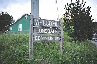
Lonsdale is a neighborhood in Knoxville, Tennessee, United States, located northwest of the city's downtown area. Established in the late-19th century as a land development project, Lonsdale incorporated as a separate city in 1907, and was annexed by Knoxville in 1917. After a period of decline in the latter half of the 20th century, Lonsdale has recently undergone several major revitalization efforts.

Forest Heights is a neighborhood in Knoxville, Tennessee. It is located in West Knoxville, surrounded by the concurrent Interstates 40 and 75 to the north, Highland Memorial Cemetery to the west, and Sutherland Avenue to the south. The oldest parts of the neighborhood along Forest Hills Boulevard have been listed on the National Register of Historic Places as the Forest Hills Boulevard Historic District.
West Hills is a neighborhood in Knoxville, Tennessee, United States, located just off Kingston Pike in West Knoxville. Initially developed in the 1950s, West Hills was Knoxville's first major post-World War II subdivision, and the first subdivision to consist primarily of modern ranch-style houses. While West Knoxville experienced a boom in commercial development in the 1970s and 1980s, West Hills has managed to retain its residential character, due in large part to its aggressive neighborhood advocacy group, the West Hills Community Association.

Chilhowee Park is a residential neighborhood in Knoxville, Tennessee, United States, located off Magnolia Avenue in the East Knoxville area. Developed as a streetcar suburb in the 1890s, this neighborhood was initially part of Park City, which was incorporated as a separate city in 1907, and annexed by Knoxville in 1917. Chilhowee Park lies adjacent to one of Knoxville's largest municipal parks, as well as Zoo Knoxville. The neighborhood contains a notable number of early-20th-century houses.
Coordinates: 36°00′14″N83°58′55″W / 36.004°N 83.982°W
| | This Knox County, Tennessee geography–related article is a stub. You can help Wikipedia by expanding it. |