Cumming, Iowa

Last updated

Cumming, Iowa
Warren County Iowa Incorporated and Unincorporated areas Cumming Highlighted.svg
Location of Cumming, Iowa
Coordinates: 41°29′15″N93°45′34″W / 41.48750°N 93.75944°W / 41.48750; -93.75944
Country Flag of the United States (23px).png  United States
State Flag of Iowa.svg  Iowa
County Warren
Area
[1]
  Total2.54 sq mi (6.59 km2)
  Land2.54 sq mi (6.56 km2)
  Water0.01 sq mi (0.03 km2)
Elevation
[2]
981 ft (299 m)
Population
 (2020)
  Total436
  Estimate 
(2023)
501
  Density171.99/sq mi (66.41/km2)
Time zone UTC-6 (Central (CST))
  Summer (DST) UTC-5 (CDT)
ZIP code
50061
Area code 515
FIPS code 19-17850
GNIS feature ID2393695 [2]

Cumming is a city in Warren County, Iowa, United States. The population was 436 at the time of the 2020 census. [3] It is the hometown of former Senator Tom Harkin.

Contents

A part of the Des Moines West Des Moines Metropolitan Statistical Area, Cumming is considered one of the smallest incorporated suburbs of the metro area. [4] The smallest of all cities in the five-county metro area is Bevington, in Madison and Warren counties, which had a population of 58 in 2000. [5]

Geography

According to the United States Census Bureau, the city has a total area of 2.57 square miles (6.66 km2), of which, 2.56 square miles (6.63 km2) is land and 0.01 square miles (0.03 km2) is water. [6]

The Great Western Trail passes through the city. [7]

Demographics

Historical populations
YearPop.±%
1930 149    
1940 139−6.7%
1950 131−5.8%
1960 148+13.0%
1970 189+27.7%
1980 151−20.1%
1990 132−12.6%
2000 162+22.7%
2010 351+116.7%
2020 436+24.2%
2023(est.)501+14.9%
Source: "U.S. Census website". United States Census Bureau . Retrieved March 29, 2020. and Iowa Data Center
Source:
U.S. Decennial Census [8] [3]
The population of Cumming, Iowa from US census data CummingIowaPopPlot.png
The population of Cumming, Iowa from US census data

2010 census

As of the census [9] of 2010, there were 351 people, 128 households, and 102 families living in the city. The population density was 137.1 inhabitants per square mile (52.9/km2). There were 136 housing units at an average density of 53.1 per square mile (20.5/km2). The racial makeup of the city was 96.9% White, 0.9% African American, 0.6% Asian, 0.6% from other races, and 1.1% from two or more races. Hispanic or Latino of any race were 1.1% of the population.

There were 128 households, of which 39.8% had children under the age of 18 living with them, 70.3% were married couples living together, 6.3% had a female householder with no husband present, 3.1% had a male householder with no wife present, and 20.3% were non-families. 14.1% of all households were made up of individuals, and 5.5% had someone living alone who was 65 years of age or older. The average household size was 2.74 and the average family size was 3.07.

The median age in the city was 40.1 years. 27.6% of residents were under the age of 18; 4.6% were between the ages of 18 and 24; 30.5% were from 25 to 44; 28% were from 45 to 64; and 9.4% were 65 years of age or older. The gender makeup of the city was 49.0% male and 51.0% female.

2000 census

As of the census [10] of 2000, there were 162 people, 65 households, and 52 families living in the city. The population density was 76.9 inhabitants per square mile (29.7/km2). There were 69 housing units at an average density of 32.7 per square mile (12.6/km2). The racial makeup of the city was 100.00% White.

There were 65 households, out of which 27.7% had children under the age of 18 living with them, 72.3% were married couples living together, 3.1% had a female householder with no husband present, and 18.5% were non-families. 13.8% of all households were made up of individuals, and 3.1% had someone living alone who was 65 years of age or older. The average household size was 2.48 and the average family size was 2.74.

In the city, the population was spread out, with 19.8% under the age of 18, 3.7% from 18 to 24, 30.9% from 25 to 44, 28.4% from 45 to 64, and 17.3% who were 65 years of age or older. The median age was 41 years. For every 100 females, there were 97.6 males. For every 100 females age 18 and over, there were 113.1 males.

The median income for a household in the city was $52,813, and the median income for a family was $56,071. Males had a median income of $40,893 versus $21,750 for females. The per capita income for the city was $23,575. None of the population or families were below the poverty line.

Notable people

See also

Related Research Articles

<span class="mw-page-title-main">Moulton, Iowa</span> City in Iowa, United States

Moulton is a city in Appanoose County, Iowa, United States. The population was 607 at the time of the 2020 census.

<span class="mw-page-title-main">Rembrandt, Iowa</span> City in Iowa, United States

Rembrandt is a city in Buena Vista County, Iowa, United States. The population was 209 at the time of the 2020 census.

<span class="mw-page-title-main">Rinard, Iowa</span> City in Iowa, United States

Rinard is a city in Calhoun County, Iowa, United States. The population was 38 at the time of the 2020 census.

<span class="mw-page-title-main">Arcadia, Iowa</span> City in Iowa, United States

Arcadia is a city in Carroll County, Iowa, United States. The population was 525 at the 2020 census.

<span class="mw-page-title-main">Spirit Lake, Iowa</span> City in Iowa, United States

Spirit Lake is a city in Dickinson County, Iowa, United States. The population was 5,439 at the 2020 census. It is the county seat of Dickinson County.

<span class="mw-page-title-main">Graf, Iowa</span> City in Iowa, United States

Graf is a city in Dubuque County, Iowa, United States. It is part of the 'Dubuque, Iowa Metropolitan Statistical Area'. The population was 76 at the time of the 2020 census, up from 73 in 2000.

<span class="mw-page-title-main">Luxemburg, Iowa</span> City in Iowa, United States

Luxemburg is a city in Dubuque County, Iowa, United States. It is part of the Dubuque, Iowa Metropolitan Statistical Area. The population was 245 at the time of the 2020 census, down from 246 in 2000. The White Pine Hollow State Forest is located four miles to the northwest of Luxemburg.

<span class="mw-page-title-main">Floyd, Iowa</span> City in Iowa, United States

Floyd is a city in Floyd County, Iowa, United States. The population was 313 at the time of the 2020 census.

<span class="mw-page-title-main">Imogene, Iowa</span> City in Iowa, United States

Imogene is a city in Fremont County, Iowa, United States. The population was 39 at the time of the 2020 census.

<span class="mw-page-title-main">Williams, Iowa</span> City in Iowa, United States

Williams is a city in Hamilton County, Iowa, United States. The population was 307 at the time of the 2020 census. Williams is a regional center of wind power generation.

<span class="mw-page-title-main">New London, Iowa</span> City in Iowa, United States

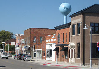
New London is a city in Henry County, Iowa, United States. The population was 1,910 at the time of the 2020 census.

<span class="mw-page-title-main">Libertyville, Iowa</span> City in Iowa, United States

Libertyville is a city in Jefferson County, Iowa, United States. The population was 274 at the time of the 2020 census. It was platted in 1845.

<span class="mw-page-title-main">Shueyville, Iowa</span> City in Iowa, United States

Shueyville is a city in Johnson County, Iowa, United States. It is part of the Iowa City, Iowa Metropolitan Statistical Area. The population was 731 at the time of the 2020 census.

<span class="mw-page-title-main">Hayesville, Iowa</span> City in Iowa, United States

Hayesville is a city in Keokuk County, Iowa, United States. The population was 41 at the time of the 2020 census.

<span class="mw-page-title-main">Springville, Iowa</span> City in Iowa, United States

Springville is a city in Linn County, Iowa, United States. The population was 1,154 at the time of the 2020 census. It is part of the Cedar Rapids Metropolitan Statistical Area.

<span class="mw-page-title-main">Mitchell, Iowa</span> City in Iowa, United States

Mitchell is a city in Mitchell County, Iowa, United States. The population was 124 at the time of the 2020 census.

<span class="mw-page-title-main">Conesville, Iowa</span> City in Iowa, United States

Conesville is a city in Muscatine County, Iowa, United States. The population was 352 at the 2020 census. It is part of the Muscatine Micropolitan Statistical Area.

<span class="mw-page-title-main">Northboro, Iowa</span> City in Iowa, United States

Northboro is a city in Page County, Iowa, United States. The population was 52 at the time of the 2020 census.

<span class="mw-page-title-main">Maysville, Iowa</span> City in Iowa, United States

Maysville is a city in Scott County, Iowa, United States. The population was 156 at the time of the 2020 census.

<span class="mw-page-title-main">Crawfordsville, Iowa</span> City in Iowa, United States

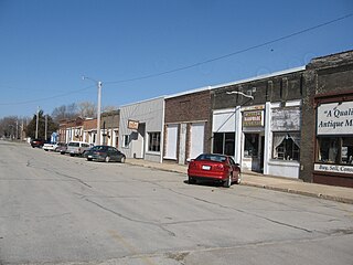
Crawfordsville is a city in Washington County, Iowa, United States. It is part of the Iowa City, Iowa Metropolitan Statistical Area. The population was 277 at the 2020 census.

References

  1. "2020 U.S. Gazetteer Files". United States Census Bureau. Retrieved March 16, 2022.
  2. 1 2 U.S. Geological Survey Geographic Names Information System: Cumming, Iowa
  3. 1 2 "2020 Census State Redistricting Data". census.gov. United states Census Bureau. Retrieved August 12, 2021.
  4. AbsoluteDSM: Cumming Photo Gallery Archived 2007-01-19 at the Wayback Machine
  5. "Subcounty population estimates: Iowa 2000-2006". United States Census Bureau, Population Division. June 28, 2007. Archived from the original (CSV) on March 5, 2008. Retrieved May 28, 2008.
  6. "US Gazetteer files 2010". United States Census Bureau. Archived from the original on January 25, 2012. Retrieved May 11, 2012.
  7. Warren County Conservation Board: Great Western Trail. Archived 2007-02-13 at the Wayback Machine
  8. "Census of Population and Housing". Census.gov. Retrieved June 4, 2015.
  9. "U.S. Census website". United States Census Bureau . Retrieved May 11, 2012.
  10. "U.S. Census website". United States Census Bureau . Retrieved January 31, 2008.