Dale, Indiana | |
---|---|
Coordinates: 38°09′59″N86°58′48″W / 38.16639°N 86.98000°W | |
Country | United States |
State | Indiana |
County | Spencer |
Township | Carter |
Area | |
• Total | 2.43 sq mi (6.29 km2) |
• Land | 2.42 sq mi (6.26 km2) |
• Water | 0.01 sq mi (0.03 km2) |
Elevation | 463 ft (141 m) |
Population (2020) | |
• Total | 1,544 |
• Density | 638.81/sq mi (246.67/km2) |
Time zone | UTC-6 (CST) |
• Summer (DST) | UTC-5 (CDT) |
ZIP code | 47523 |
Area code | 812 |
FIPS code | 18-16624 [3] |
GNIS feature ID | 2396674 [2] |
Dale is a town in Carter Township, Spencer County, in the U.S. state of Indiana. [2] The population was 1,593 at the 2010 census.
Dale was originally called Elizabeth, and under the latter name was laid out in 1843. [4] When a post office was established, the name was changed to Dale, in honor of Robert Dale Owen of New Harmony, the town's congressman at the time. [4] The Dale post office has been in operation since 1844. [5]
According to the 2010 census, Dale has a total area of 1.56 square miles (4.04 km2), of which 1.55 square miles (4.01 km2) (or 99.36%) is land and 0.01 square miles (0.03 km2) (or 0.64%) is water. [6]
Census | Pop. | Note | %± |
---|---|---|---|
1880 | 318 | — | |
1890 | 659 | 107.2% | |
1900 | 624 | −5.3% | |
1910 | 583 | −6.6% | |
1920 | 688 | 18.0% | |
1930 | 770 | 11.9% | |
1940 | 763 | −0.9% | |
1950 | 850 | 11.4% | |
1960 | 900 | 5.9% | |
1970 | 1,113 | 23.7% | |
1980 | 1,693 | 52.1% | |
1990 | 1,553 | −8.3% | |
2000 | 1,568 | 1.0% | |
2010 | 1,593 | 1.6% | |
2020 | 1,544 | −3.1% | |
U.S. Decennial Census [7] |
As of the census [8] of 2010, there were 1,593 people, 603 households, and 406 families living in the town. The population density was 1,027.7 inhabitants per square mile (396.8/km2). There were 649 housing units at an average density of 418.7 per square mile (161.7/km2). The racial makeup of the town was 84.6% White, 0.4% African American, 0.1% Native American, 0.6% Asian, 12.6% from other races, and 1.8% from two or more races. Hispanic or Latino of any race were 18.1% of the population.
There were 603 households, of which 35.3% had children under the age of 18 living with them, 51.6% were married couples living together, 10.9% had a female householder with no husband present, 4.8% had a male householder with no wife present, and 32.7% were non-families. 29.0% of all households were made up of individuals, and 14.1% had someone living alone who was 65 years of age or older. The average household size was 2.50 and the average family size was 3.08.
The median age in the town was 37.9 years. 24.9% of residents were under the age of 18; 7.6% were between the ages of 18 and 24; 24.3% were from 25 to 44; 27.3% were from 45 to 64; and 15.8% were 65 years of age or older. The gender makeup of the town was 50.4% male and 49.6% female.
As of the census [3] of 2000, there were 1,570 people, 591 households, and 414 families living in the town. The population density was 1,025.4 inhabitants per square mile (395.9/km2). There were 630 housing units at an average density of 412.0 per square mile (159.1/km2). The racial makeup of the town was 92.35% White, 1.02% African American, 6.12% from other races, and 0.51% from two or more races. Hispanic or Latino of any race were 9.44% of the population.
There were 591 households, out of which 31.6% had children under the age of 18 living with them, 55.2% were married couples living together, 10.7% had a female householder with no husband present, and 29.9% were non-families. 26.7% of all households were made up of individuals, and 13.9% had someone living alone who was 65 years of age or older. The average household size was 2.53 and the average family size was 3.05.
In the town, the population was spread out, with 24.5% under the age of 18, 9.2% from 18 to 24, 28.2% from 25 to 44, 20.7% from 45 to 64, and 17.4% who were 65 years of age or older. The median age was 37 years. For every 100 females, there were 90.8 males. For every 100 females age 18 and over, there were 91.6 males.
The median income for a household in the town was $36,295, and the median income for a family was $42,969. Males had a median income of $29,018 versus $22,545 for females. The per capita income for the town was $16,163. About 2.7% of families and 4.5% of the population were below the poverty line, including 4.6% of those under age 18 and 2.6% of those age 65 or over.
Dale has a public library, a branch of the Lincoln Heritage Public Library. [9]
Has a public elementary school [10]
The Indiana Department of Transportation, as part of the Major Moves transportation program, in 2011 completed a four-lane, limited access highway bypass that carries U.S. Route 231 around the west side of Dale. The town now has access points at Indiana 62 on the town's south side, Indiana 68 on the west side, and Spencer County Road 2050 North (a new roadway) on the north side.
County Road 2050 North provides access to two hotels, a restaurant, gas station and residences that were formerly accessed from the old interchange of U.S. 231 with Interstate 64. That diamond interchange and overpass were eliminated in favor of a partial-cloverleaf interchange located slightly to the west, necessitating the access road.
Ambia is a town in Hickory Grove Township, Benton County, Indiana, United States. The population was 239 at the 2010 census. It is part of the Lafayette, Indiana Metropolitan Statistical Area.
Milltown is a town in Whiskey Run Township in Crawford County, Indiana and in Blue River and Spencer townships in Harrison County. The population was 818 at the time of the 2010 census.
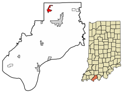
West Harrison is a town in Harrison Township, Dearborn County, Indiana, United States. The population was 289 at the 2010 census.
Albany is a town in Delaware and Randolph counties in the U.S. state of Indiana, along the Mississinewa River. The population was 2,295 at the 2020 census. It is part of the Muncie, IN Metropolitan Statistical Area.
Daleville is a town in Salem Township, Delaware County, Indiana, United States. The population was 1,651 at the 2020 census. It is part of the Muncie, IN Metropolitan Statistical Area.
McCordsville is a town in Vernon Township, Hancock County, Indiana, United States. The town is a fast-growing suburb of Indianapolis with an estimated population of 8,592 in 2020.
Medora is a town in Carr Township, Jackson County, Indiana, United States. The population was 693 at the 2010 census.
Dupont is a town in Lancaster Township, Jefferson County, Indiana, United States. The population was 339 at the 2010 census.
New Whiteland is a town in Pleasant Township, Johnson County, Indiana, United States. The population was 5,550 at the 2020 census.
Macy is a town in Allen Township, Miami County, in the U.S. state of Indiana. The population was 199 at the 2020 census.
Bethany is a town in Clay Township, Morgan County, in the U.S. state of Indiana. The population was 95 at the 2020 census.
Paragon is a town in Ray Township, Morgan County, in the U.S. state of Indiana. The population was 556 at the 2020 census, down from 659 in 2010.
Spencer is a town in Washington Township, Owen County, in the U.S. state of Indiana. The population was 2,217 at the 2010 census. It is the county seat of Owen County.
Troy is a town in Troy Township, Perry County, Indiana, along the Ohio River near the mouth of the Anderson River. It is the second oldest city in Indiana. The population was 347 at the 2020 census.
Cloverdale is a town in Cloverdale and Warren townships, Putnam County, in the U.S. state of Indiana. The population was 2,172 at the 2010 census.
Chrisney is a town in Grass Township, Spencer County, in the U.S. state of Indiana. The population was 481 at the 2010 census.
Gentryville is a town in Jackson Township, Spencer County, in the U.S. state of Indiana. The population was 268 at the 2010 census.
Grandview is a town in Hammond Township, Spencer County, Indiana, along the Ohio River. The population was 749 at the 2010 census.
Rockport is a city in Ohio Township and the county seat of Spencer County, Indiana, along the Ohio River. The population was 2,270 at the 2010 census. Once the largest community in Spencer County, the city has recently been surpassed by the town of Santa Claus. At 37°53'1" north, Rockport is also the southernmost city in the state, located slightly south of Evansville, Cannelton, or Mount Vernon.
Glen Dale is a city in Marshall County, West Virginia, United States, along the Ohio River. It is part of the Wheeling, West Virginia Metropolitan Statistical Area. The population was 1,514 at the 2020 census. Glen Dale was incorporated in 1924. It is in the northwest part of the county, which is above the Mason–Dixon line and forms the base of the Northern Panhandle of West Virginia.