The Western Heights of Dover are one of the most impressive fortifications in Britain. They comprise a series of forts, strong points and ditches, designed to protect the country from invasion. They were created in the 18th and 19th centuries to augment the existing defences and protect the key port of Dover from both seaward and landward attack; by the start of the 20th century Dover Western Heights was collectively reputed to be the 'strongest and most elaborate' fortification in the country. The Army finally withdrew from the Heights in 1956–61; they are now a local nature reserve.

Shornemead Fort is a now-disused artillery fort that was built in the 1860s to guard the entrance to the Thames from seaborne attack. Constructed during a period of tension with France, it stands on the south bank of the river at a point where the Thames curves sharply north and west, giving the fort long views up and downriver in both directions. It was the third fort constructed on the site since the 18th century, but its location on marshy ground led to major problems with subsidence. The fort was equipped for a time with a variety of large-calibre artillery guns which were intended to support two other nearby Thamesside forts. However, the extent of the subsidence meant that it became unsafe for the guns to be fired and the fort was disarmed by the early 20th century.
Coalhouse Fort is an artillery fort in the eastern English county of Essex. It was built in the 1860s to guard the lower Thames from seaborne attack. It stands at Coalhouse Point on the north bank of the river, at a location near East Tilbury which was vulnerable to raiders and invaders. It was the last in a series of fortifications dating back to the 15th century and was the direct successor to a smaller mid-19th century fort built on the same site. Constructed during a period of tension with France, its location on marshy ground caused problems from the start and led to a lengthy construction process. The fort was equipped with a variety of large-calibre artillery guns and the most modern defensive facilities of the time, including shell-proof casemates protected by granite facing and cast-iron shields. Its lengthy construction and the rapid pace of artillery development at the time meant that it was practically obsolete for its original purpose within a few years of its completion.

Beacon Hill Battery is a late-19th and 20th century coastal fortification that was built to defend the port of Harwich, Essex. It is a scheduled ancient monument.

Fort Bovisand is a fort in Devon, England near the beach of Bovisand. It was built as a result of the Royal Commission on the Defence of the United Kingdom which reported in 1860. It is located on the mainland to defend the entrance of Plymouth Sound, at the narrows opposite the east end of Plymouth Breakwater. The fort is beside Bovisand harbour.
Fort Hubberstone, on the west side of Milford Haven, Pembrokeshire, is a Grade II* Listed Building which belongs to a series of forts built as part of the inner line of defence of the Haven following the Royal Commission on the Defence of the United Kingdom. Together with Popton Fort on the opposite shore, it provided an interlocking field of fire, and represented the last layer of defence before reaching the Royal Naval dockyard at Pembroke Dock. Construction began in 1860 and was completed in 1863 at a cost of £55,000. It is a large battery, with eleven guns in casemates, eight in an open battery above, with another nine in an open flank battery, and a large barracks to the rear. It is a D-shaped structure, with a bomb-proof roof which protected the barracks and other buildings from mortar projectiles. On its landward side, it was protected by a deep ditch, and on the seaward side by a counter-scarp gallery. The associated casemate battery is located further down the headland and separated from the fort.

Stack Rock Fort is a fort built on a small island in the Milford Haven Waterway, Pembrokeshire, Wales. A 3-gun fort was built between 1850 and 1852, and then upgraded from 1859 to 1871 with a new building that completely encased the original gun tower. It is now a Grade II* listed building and a scheduled monument.
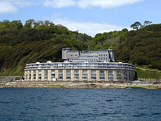
Fort Picklecombe stands on the extreme south eastern coast of Cornwall, a couple of miles west of the city of Plymouth. The fort has been a residential complex since the early 1970s but has a history dating back 150 years.

Dale is both a small village and a community in Pembrokeshire, Wales, located on the peninsula which forms the northern side of the entrance to the Milford Haven Waterway. The village has 205 inhabitants according to the 2001 census, increasing to 225 at the 2011 Census.

Fort Tourgis is an extensive fortification in Alderney to the north west of St Anne forming part of the Fortifications of Alderney.
Lavernock Battery was built at Lavernock Point, Wales on the recommendations of the 1860 Royal Commission during the late 1860s to protect the ports of the Severn Estuary. It was replaced by a new anti-aircraft battery during World War II that was equipped with four heavy anti-aircraft guns.

Whitsand Bay, situated in south east Cornwall, England, runs from Rame Head in the east to Portwrinkle in the west. It is characterised by sheer, high cliffs, dramatic scenery and long stretches of sandy beaches. The South West Coast Path runs the length of the bay.

Thorne Island is a rocky islet and part of the community of Angle, Pembrokeshire, Wales, with an area of 2 acres (8,100 m2), dominated by a coastal artillery fort built to defend the Milford Haven Waterway in the mid-19th century. It has been the site of a number of shipwrecks, including one in 1894 that was carrying a cargo of Scotch whisky.

Freshwater Redoubt, also known as Fort Redoubt, is an old Palmerston fort built in Freshwater Bay on the western end of the Isle of Wight. Construction work for the fort began in 1855 and was completed in 1856. It was finally sold in 1928 and has now been converted into a private residence.

St Catherine's Fort is a 19th-century Palmerston Fort on St Catherine's Island, at Tenby, Pembrokeshire, Wales.

Apart from a Roman Fort, there were very few fortifications in Alderney until the mid 19th century. These were then modified and updated in the mid 20th Century by Germans during the occupation period. Alderney at 8 km2 is now one of the most fortified places in the world.

West Blockhouse Fort is a mid-19th century coastal artillery fort at West Blockhouse Point, a rocky headland near Dale, Pembrokeshire, to the west of Milford Haven in Wales.

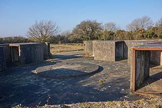
Maker Battery is a former 19th-century coastal artillery battery, built to strengthen the defence of the Royal Naval Dockyard at Devonport.
Grenville Battery is a former coastal artillery battery, built to defend the Royal Naval Dockyard at Devonport.

Hawkins Battery is a former coastal artillery battery, built to defend the Royal Naval Dockyard at Devonport.