Daleville, Indiana

Last updated

Daleville
Daleville, Indiana.jpg
Downtown Daleville
Delaware County Indiana Incorporated and Unincorporated areas Daleville Highlighted 1816642.svg
Location of Daleville in Delaware County, Indiana.
USA Indiana location map.svg
Red pog.svg
Daleville
Coordinates: 40°07′25″N85°33′12″W / 40.12361°N 85.55333°W / 40.12361; -85.55333
Country United States
State Indiana
County Delaware
Township Salem
Area
[1]
  Total2.15 sq mi (5.57 km2)
  Land2.13 sq mi (5.51 km2)
  Water0.02 sq mi (0.06 km2)
Elevation
[2]
915 ft (279 m)
Population
 (2020)
  Total1,651 [3]
  Density775.85/sq mi (299.51/km2)
Time zone UTC-5 (EST)
  Summer (DST) UTC-5 (EST)
ZIP code
47334
Area code 765
FIPS code 18-16642 [4]
GNIS feature ID2396675 [2]

Daleville is a town in Salem Township, Delaware County, Indiana, United States. The population was 1,651 at the 2020 census. It is part of the Muncie, IN Metropolitan Statistical Area. [5]

Contents

History

Daleville was founded by American Revolutionary War veteran Alexander "Campbell" Dale. [6]

Daleville was named Campbell Dale, when his family settled at the site in the 1820s. [7] It was platted in 1838. [8]

Daleville is the newest town in Indiana, as it was officially incorporated as a town in 1982. [9]

The Daleville Broncos high school baseball team won the 2016 and 2018 Indiana high school athletic association 1a baseball state titles.

Daleville from above, looking southwest Daleville-indiana-from-above.jpg
Daleville from above, looking southwest

Geography

According to the 2010 census, Daleville has a total area of 2.07 square miles (5.36 km2), of which 2.05 square miles (5.31 km2) (or 99.03%) is land and 0.02 square miles (0.05 km2) (or 0.97%) is water. [10]

Demographics

Historical population
CensusPop.Note
1880 297
1990 1,681
2000 1,658−1.4%
2010 1,647−0.7%
2020 1,6510.2%
2022 (est.)1,687 [11] 2.2%
U.S. Decennial Census [12]

2020 census

As of the census [3] of 2020, there were 1,651 people, 709 households, and 344 families living in the town. The population density was 767.9 inhabitants per square mile (296.5/km2). There were 768 housing units at an average density of 357.2 per square mile (137.9/km2). The racial makeup of the town was 92.3% White, 2.1% African American, 6.7% Asian, 0.1% Native American or Alaskan Native, 0.3% from other races, and 4.5% from two or more races. Hispanic or Latino of any race were 2.1% of the population.

There were 709 households, of which 19.8% had children under the age of 18 living with them, 48.8% were married couples living together, 25.7% had a female householder with no husband present, 14.9% had a male householder with no wife present, and 10.6% were non-families. 40.6% of all households were made up of individuals. The average household size was 2.33 and the average family size was 2.82.

24.2% of the population had never been married. 51.5% of residents were married and not separated, 8.2% were widowed, 14.4% were divorced, and 1.8% were separated.

The median age in the town was 41.0. 6.5% of residents were under the age of 5; 19.8% of residents were under the age of 18; 80.2% were age 18 or older; and 19.5% were age 65 or older. 6.9% of the population were veterans.

The most common language spoken at home was English with 96.8% speaking it at home, 2.5% spoke Spanish at home, 0.5% spoke another Indo-European language at home, and 0.3% spoke an Asian or Pacific Islander language at home. 1.9% of the population were foreign born.

The median household income in Gaston was $48,333, 14.0% less than the median average for the state of Indiana. 13.3% of the population were in poverty, including 24.7% of residents under the age of 18. The poverty rate for the town was 0.4% higher than that of the state. 18.3% of the population was disabled and 8.3% had no healthcare coverage. 41.7% of the population had attained a high school or equivalent degree, 24.2% had attended college but received no degree, 10.0% had attained an Associate's degree or higher, 8.9% had attained a Bachelor's degree or higher, and 9.8% had a graduate or professional degree. 5.6% had no degree. 58.5% of Daleville residents were employed, working a mean of 38.2 hours per week. The median gross rent in Daleville was $713 and the homeownership rate was 72.2%. 59 housing units were vacant at a density of 27.4 per square mile (10.6/km2).

2010 census

As of the census [13] of 2010, there were 1,647 people, 671 households, and 457 families living in the town. The population density was 803.4 inhabitants per square mile (310.2/km2). There were 716 housing units at an average density of 349.3 per square mile (134.9/km2). The racial makeup of the town was 97.6% White, 0.4% African American, 0.1% Native American, 0.7% Asian, 0.1% Pacific Islander, 0.1% from other races, and 1.0% from two or more races. Hispanic or Latino of any race were 0.5% of the population.

There were 671 households, of which 30.8% had children under the age of 18 living with them, 50.4% were married couples living together, 12.1% had a female householder with no husband present, 5.7% had a male householder with no wife present, and 31.9% were non-families. 28.0% of all households were made up of individuals, and 9.4% had someone living alone who was 65 years of age or older. The average household size was 2.45 and the average family size was 2.97.

The median age in the town was 40 years. 22.9% of residents were under the age of 18; 8.6% were between the ages of 18 and 24; 24.2% were from 25 to 44; 29.5% were from 45 to 64; and 14.7% were 65 years of age or older. The gender makeup of the town was 47.8% male and 52.2% female.

2000 census

As of the census [4] of 2000, there were 1,658 people, 650 households, and 453 families living in the town. The population density was 832.4 inhabitants per square mile (321.4/km2). There were 688 housing units at an average density of 345.4 per square mile (133.4/km2). The racial makeup of the town was 98.97% White, 0.12% African American, 0.24% Native American, 0.06% Asian, 0.36% from other races, and 0.24% from two or more races. Hispanic or Latino of any race were 0.72% of the population.

There were 650 households, out of which 35.2% had children under the age of 18 living with them, 57.2% were married couples living together, 9.5% had a female householder with no husband present, and 30.2% were non-families. 25.8% of all households were made up of individuals, and 11.5% had someone living alone who was 65 years of age or older. The average household size was 2.55 and the average family size was 3.09.

In the town, the population was spread out, with 28.0% under the age of 18, 8.1% from 18 to 24, 30.3% from 25 to 44, 21.8% from 45 to 64, and 11.8% who were 65 years of age or older. The median age was 35 years. For every 100 females, there were 90.6 males. For every 100 females age 18 and over, there were 89.7 males.

The median income for a household in the town was $40,592, and the median income for a family was $48,289. Males had a median income of $36,500 versus $23,182 for females. The per capita income for the town was $18,020. About 2.3% of families and 2.7% of the population were below the poverty line, including 1.6% of those under age 18 and 6.2% of those age 65 or over.

Education

Daleville Public Schools belong to the Daleville Community Schools school district. The district has one elementary school and one junior/senior high school. Students attend Daleville High School. [14] [15]

Related Research Articles

<span class="mw-page-title-main">Daleville, Alabama</span> City in Alabama, United States

Daleville is a city in Dale County, Alabama, United States. At the 2010 census the population was 5,295, up from 4,653 in 2000. It is part of the Ozark Micropolitan Statistical Area. The city's nickname is "Gateway to Fort Rucker", as this U.S. Army post is located just north of town. Cairns Army Airfield is located to the south of Daleville on the road to nearby Clayhatchee.

<span class="mw-page-title-main">Walton, Indiana</span> Town in Indiana, United States

Walton is a town in Tipton Township, Cass County, Indiana, United States. The population was 1,049 at the 2010 census.

<span class="mw-page-title-main">St. Leon, Indiana</span> Town in Indiana, United States

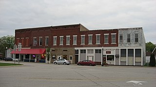
St. Leon or Saint Leon is a town in Kelso Township, Dearborn County, Indiana, United States. The population was 678 at the 2010 census.

<span class="mw-page-title-main">Albany, Indiana</span> Town in Indiana, United States

Albany is a town in Delaware and Randolph counties in the U.S. state of Indiana, along the Mississinewa River. The population was 2,295 at the 2020 census. It is part of the Muncie, IN Metropolitan Statistical Area.

<span class="mw-page-title-main">Chesterfield, Indiana</span> Town in Indiana, United States

Chesterfield is a town in the U.S. state of Indiana which lies in Union Township, Madison County, and Salem Township, Delaware County. The population was 2,490 at the 2020 census. It is part of the Indianapolis–Carmel–Anderson metropolitan statistical area.

<span class="mw-page-title-main">Eaton, Indiana</span> Town in Indiana, United States

Eaton is a town in Union Township, Delaware County, Indiana, along the Mississinewa River. The population was 1,595 at the 2020 census. It is part of the Muncie Metropolitan Statistical Area.

<span class="mw-page-title-main">Gaston, Indiana</span> Town in Indiana, United States

Gaston is a town in Washington Township, Delaware County, Indiana, United States. The population was 796 at the 2020 census. It is part of the Muncie Metropolitan Statistical Area.

<span class="mw-page-title-main">Selma, Indiana</span> Town in Indiana, United States

Selma is a town in Liberty Township, Delaware County, Indiana, United States. As of the 2020 census, the town had a total population of 747. It is part of the Muncie, IN Metropolitan Statistical Area.

<span class="mw-page-title-main">Somerville, Indiana</span> Town in Indiana, United States

Somerville is a town in Barton Township, Gibson County, Indiana, United States. The population was 293 at the 2010 census, making it the third-smallest community in the county.

<span class="mw-page-title-main">Worthington, Indiana</span> Town in Indiana, United States

Worthington is a town in Jefferson Township, Greene County, Indiana, United States. The population was 1,463 at the 2010 United States Census. It is part of the Bloomington, Indiana, Metropolitan Statistical Area.

<span class="mw-page-title-main">McCordsville, Indiana</span> Town in Indiana, United States

McCordsville is a town in Vernon Township, Hancock County, Indiana, United States. The town is a fast-growing suburb of Indianapolis with an estimated population of 8,592 in 2020.

<span class="mw-page-title-main">Stilesville, Indiana</span> Town in Indiana, United States

Stilesville is a town in Franklin Township, Hendricks County, Indiana, United States. The population was 316 at the 2010 Census.

<span class="mw-page-title-main">Brownstown, Indiana</span> Town in Indiana, United States

Brownstown is a town within Brownstown Township and the county seat of Jackson County, Indiana, United States. The population was 2,947 at the 2010 census. It was named for Jacob Brown, a general of the War of 1812.

<span class="mw-page-title-main">Bargersville, Indiana</span> Town in Indiana, United States

Bargersville is a town in White River and Union townships, Johnson County, Indiana, United States. The population was 9,560 at the 2020 census.

<span class="mw-page-title-main">New Whiteland, Indiana</span> Town in Indiana, United States

New Whiteland is a town in Pleasant Township, Johnson County, Indiana, United States. The population was 5,550 at the 2020 census.

<span class="mw-page-title-main">Prince's Lakes, Indiana</span> Town in Indiana, United States

Prince's Lakes is a town in Nineveh Township, Johnson County, Indiana, United States. The population was 1,312 at the 2010 census.

<span class="mw-page-title-main">Syracuse, Indiana</span> Town in Indiana, United States

Syracuse is a town in Turkey Creek Township, Kosciusko County, in the U.S. state of Indiana. The population was 3,079 at the 2020 census. Syracuse is the location of Lake Syracuse and the nearby, larger Lake Wawasee, in addition to several other lakes in the region. The National Weather Service operates a Weather Forecast Office South of town, toward North Webster. It serves Northern Indiana.

<span class="mw-page-title-main">Wolcottville, Indiana</span> Town in Indiana, United States

Wolcottville is a town in Orange Township, Noble County and Johnson Township, LaGrange County in the U.S. state of Indiana. The population was 998 at the 2010 census.

<span class="mw-page-title-main">Paragon, Indiana</span> Town in Indiana, United States

Paragon is a town in Ray Township, Morgan County, in the U.S. state of Indiana. The population was 556 at the 2020 census, down from 659 in 2010.

<span class="mw-page-title-main">Fillmore, Indiana</span> Town in Indiana, United States

Fillmore is a town in Marion Township, Putnam County, in the U.S. state of Indiana. The population was 532 at the 2020 census.

References

  1. "2020 U.S. Gazetteer Files". United States Census Bureau. Retrieved March 16, 2022.
  2. 1 2 U.S. Geological Survey Geographic Names Information System: Daleville, Indiana
  3. 1 2 "Daleville town, Indiana - Census Bureau Profile". Archived from the original on May 2, 2022. Retrieved May 2, 2022.
  4. 1 2 "U.S. Census website". United States Census Bureau . Retrieved January 31, 2008.
  5. "Profile for Daleville, Indiana, IN". ePodunk. Retrieved September 25, 2012.
  6. "The "Newest Town" in Indiana".
  7. Kemper, William Harrison (1908). A Twentieth Century History of Delaware County, Indiana, Volume 1. Lewis Publishing Company. p. 98.
  8. Lasley, Norma (2012). Delaware County. Arcadia Publishing. p. 21. ISBN   978-0-7385-9430-9.
  9. "Daleville, Indiana". City-Data.om. Retrieved September 25, 2012.
  10. "G001 - Geographic Identifiers - 2010 Census Summary File 1". United States Census Bureau. Archived from the original on February 13, 2020. Retrieved July 16, 2015.
  11. "Population Estimates for Indiana's Incorporated Places, 2020-2022". StatsIndiana. Retrieved January 23, 2024.
  12. "Census of Population and Housing". Census.gov. Retrieved June 4, 2016.
  13. "U.S. Census website". United States Census Bureau . Retrieved December 11, 2012.
  14. "Daleville Community Schools". Daleville Community Schools. Archived from the original on November 4, 2012. Retrieved September 25, 2012.
  15. "Daleville Community Schools/". Great Schools, Inc. Retrieved September 25, 2012.