Selma, Indiana

Last updated

Selma, Indiana
Selma, Indiana.jpg
Main street
Delaware County Indiana Incorporated and Unincorporated areas Selma Highlighted 1868706.svg
Location of Selma in Delaware County, Indiana.
Coordinates: 40°11′26″N85°16′13″W / 40.19056°N 85.27028°W / 40.19056; -85.27028
Country United States
State Indiana
County Delaware
Township Liberty
Area
[1]
  Total0.90 sq mi (2.33 km2)
  Land0.90 sq mi (2.32 km2)
  Water0.00 sq mi (0.01 km2)
Elevation
[2]
1,004 ft (306 m)
Population
 (2020)
  Total747 [3]
  Density834.64/sq mi (322.17/km2)
Time zone UTC-5 (Eastern (EST))
  Summer (DST) UTC-4 (EDT)
ZIP code
47383
Area code 765
FIPS code 18-68706 [4]
GNIS feature ID2397650 [2]

Selma is a town in Liberty Township, Delaware County, Indiana, United States. As of the 2020 census, the town had a total population of 747. It is part of the Muncie, IN Metropolitan Statistical Area.

Contents

History

Selma was platted in 1852 when the railroad was extended to that point. [5] The Selma post office was established in 1853. [6]

Affected by the Indiana Gas Boom, gas and oil were the primary industries of Selma in the late 19th and early 20th centuries. Selma was incorporated as a town in 1907. [7]

On March 14, 2024, Selma was hit by a strong EF2 tornado, which mainly hit northern areas of Selma.

Geography

Indiana State Road 32 runs along the northern edge of the town.

According to the 2010 census, Selma has a total area of 0.912 square miles (2.36 km2), of which 0.91 square miles (2.36 km2) (or 99.78%) is land and 0.002 square miles (0.01 km2) (or 0.22%) is water. [8]

Demographics

Historical population
CensusPop.Note
1880 244
1910 350
1920 318−9.1%
1930 3448.2%
1940 42423.3%
1950 49917.7%
1960 56212.6%
1970 89058.4%
1980 1,05618.7%
1990 800−24.2%
2000 88010.0%
2010 866−1.6%
2020 747−13.7%
2022 (est.)743 [9] −0.5%
U.S. Decennial Census [10]

2020 census

As of the census [3] of 2020, there were 747 people, 313 households, and 91 families living in the town. The population density was 830 inhabitants per square mile (320.5/km2). There were 345 housing units at an average density of 383.3 per square mile (148.0/km2). The racial makeup of the town was 93.3% White, 0.5% African American, 0.4% Native American or Alaskan Native, 0.1% Asian, 0.1% Native Hawaiian or Pacific Islander, 0.2% from other races, and 5.2% from two or more races. Hispanic or Latino of any race were 1.9% of the population.

There were 313 households, of which 25.4% had children under the age of 18 living with them, 49.9% were married couples living together, 28.9% had a female householder with no husband present, 11.5% had a male householder with no wife present, and 9.7% were non-families. 40.4% of all households were made up of individuals. The average household size was 2.39 and the average family size was 3.07.

38.6% of the population had never been married. 47.1% of residents were married and not separated, 5.4% were widowed, 7.7% were divorced, and 1.2% were separated.

The median age in the town was 35.5. 4.8% of residents were under the age of 5; 25.4% of residents were under the age of 18; 74.6% were age 18 or older; and 11.7% were age 65 or older. 6.3% of the population were veterans.

The most common language spoken at home was English with 99.1% speaking it at home, 0.4% spoke Spanish at home and 0.4% spoke another Indo-European language at home. 0.4% of the population were foreign born.

The median household income in Gaston was $48,036, 14.5% less than the median average for the state of Indiana. 21.6% of the population were in poverty, including 24.8% of residents under the age of 18. The poverty rate for the town was 8.7% higher than that of the state. 18.4% of the population was disabled and 9.2% had no healthcare coverage. 50.0% of the population had attained a high school or equivalent degree, 23.5% had attended college but received no degree, 6.9% had attained an Associate's degree or higher, 10.0% had attained a Bachelor's degree or higher, and 0.6% had a graduate or professional degree. 9.0% had no degree. 58.6% of Selma residents were employed, working a mean of 35.4 hours per week. The median gross rent in Selma was $611 and the homeownership rate was 65.5%. 32 housing units were vacant at a density of 35.6 per square mile (13.7/km2).

2010 census

As of the census [11] of 2010, there were 866 people, 337 households, and 239 families living in the town. The population density was 951.6 inhabitants per square mile (367.4/km2). There were 377 housing units at an average density of 414.3 per square mile (160.0/km2). The racial makeup of the town was 97.2% White, 0.7% African American, 0.5% Native American, 0.2% Asian, 0.2% Pacific Islander, 0.1% from other races, and 1.0% from two or more races. Hispanic or Latino of any race were 0.9% of the population.

There were 337 households, of which 38.6% had children under the age of 18 living with them, 50.1% were married couples living together, 15.7% had a female householder with no husband present, 5.0% had a male householder with no wife present, and 29.1% were non-families. 22.8% of all households were made up of individuals, and 10.7% had someone living alone who was 65 years of age or older. The average household size was 2.55 and the average family size was 2.98.

The median age in the town was 39 years. 26% of residents were under the age of 18; 10.4% were between the ages of 18 and 24; 24.7% were from 25 to 44; 24.8% were from 45 to 64; and 14.2% were 65 years of age or older. The gender makeup of the town was 47.2% male and 52.8% female.

2000 census

As of the census [4] of 2000, there were 880 people, 336 households, and 250 families living in the town. The population density was 1,037.2 inhabitants per square mile (400.5/km2). There were 349 housing units at an average density of 411.4 per square mile (158.8/km2). The racial makeup of the town was 97.84% White, 0.57% African American, 0.34% Native American, 0.00% Asian, 0.00% Pacific Islander, 0.11% from other races, and 1.14% from two or more races. 0.34% of the population were Hispanic or Latino of any race.

There were 336 households, out of which 40.2% had children under the age of 18 living with them, 59.2% were married couples living together, 13.1% had a female householder with no husband present, and 25.3% were non-families. 22.0% of all households were made up of individuals, and 10.7% had someone living alone who was 65 years of age or older. The average household size was 2.59 and the average family size was 3.00.

In the town, the population was spread out, with 28.4% under the age of 18, 7.8% from 18 to 24, 31.7% from 25 to 44, 19.3% from 45 to 64, and 12.7% who were 65 years of age or older. The median age was 34 years. For every 100 females there were 88.8 males. For every 100 females age 18 and over, there were 86.9 males.

The median income for a household in the town was $44,423, and the median income for a family was $50,357. Males had a median income of $35,333 versus $23,625 for females. The per capita income for the town was $18,361. 4.7% of the population and 4.5% of families were below the poverty line. Out of the total population, 7.1% of those under the age of 18 and 3.8% of those 65 and older were living below the poverty line.

Notable People

Related Research Articles

<span class="mw-page-title-main">Advance, Indiana</span> Town in Indiana, United States

Advance is a town in Jackson Township, Boone County, Indiana, United States. The population was 503 at the 2020 census.

<span class="mw-page-title-main">Chesterfield, Indiana</span> Town in Indiana, United States

Chesterfield is a town in the U.S. state of Indiana which lies in Union Township, Madison County, and Salem Township, Delaware County. The population was 2,490 at the 2020 census. It is part of the Indianapolis–Carmel–Anderson metropolitan statistical area.

<span class="mw-page-title-main">Atlanta, Indiana</span> Town in Indiana, United States

Atlanta is a town in Jackson Township, Hamilton County, Indiana, United States. The population was 725 at the 2010 census.

<span class="mw-page-title-main">McCordsville, Indiana</span> Town in Indiana, United States

McCordsville is a town in Vernon Township, Hancock County, Indiana, United States. The town is a fast-growing suburb of Indianapolis with an estimated population of 8,592 in 2020.

<span class="mw-page-title-main">Wilkinson, Indiana</span> Town in Indiana, United States

Wilkinson is a town in Brown Township, Hancock County, Indiana, United States. The population was 449 at the 2010 census.

<span class="mw-page-title-main">Spiceland, Indiana</span> Town in Indiana, United States

Spiceland is a town in Spiceland Township, Henry County, Indiana, United States. The population was 890 at the 2010 census.

<span class="mw-page-title-main">Brownstown, Indiana</span> Town in Indiana, United States

Brownstown is a town within Brownstown Township and the county seat of Jackson County, Indiana, United States. The population was 2,947 at the 2010 census. It was named for Jacob Brown, a general of the War of 1812.

<span class="mw-page-title-main">Medora, Indiana</span> Town in Indiana, United States

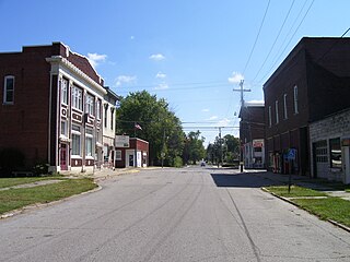
Medora is a town in Carr Township, Jackson County, Indiana, United States. The population was 693 at the 2010 census.

<span class="mw-page-title-main">Bargersville, Indiana</span> Town in Indiana, United States

Bargersville is a town in White River and Union townships, Johnson County, Indiana, United States. The population was 9,560 at the 2020 census.

<span class="mw-page-title-main">Whiteland, Indiana</span> Town in Indiana, United States

Whiteland is a town in Pleasant, Franklin and Clark townships, Johnson County, Indiana, United States. The population was 4,599 at the 2020 census.

<span class="mw-page-title-main">Etna Green, Indiana</span> Town in Indiana, United States

Etna Green is a town in Etna Township, Kosciusko County, in the U.S. state of Indiana. The population was 586 at the 2010 census.

<span class="mw-page-title-main">Syracuse, Indiana</span> Town in Indiana, United States

Syracuse is a town in Turkey Creek Township, Kosciusko County, in the U.S. state of Indiana. The population was 3,079 at the 2020 census. Syracuse is the location of Lake Syracuse and the nearby, larger Lake Wawasee, in addition to several other lakes in the region. The National Weather Service operates a Weather Forecast Office South of town, toward North Webster. It serves Northern Indiana, Northwestern Ohio and Southwestern Michigan.

<span class="mw-page-title-main">Topeka, Indiana</span> Town in Indiana, United States

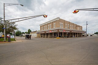
Topeka is a town in Clearspring and Eden townships, LaGrange County, Indiana, United States. The population was 1,153 at the 2010 census. Topeka is located approximately eleven miles south of Shipshewana, Indiana.

<span class="mw-page-title-main">Ingalls, Indiana</span> Town in Indiana, United States

Ingalls is a town in Green Township, Madison County, Indiana, United States. It is part of the Indianapolis–Carmel–Anderson metropolitan statistical area. The population was 2,223 at the 2020 census.

<span class="mw-page-title-main">Morgantown, Indiana</span> Town in Indiana, United States

Morgantown is a town at the intersection of Indiana state routes 135 and 252 in Jackson Township, Morgan County, in the U.S. state of Indiana. The population was 1,014 at the 2020 census.

<span class="mw-page-title-main">Marshall, Indiana</span> Town in Indiana, United States

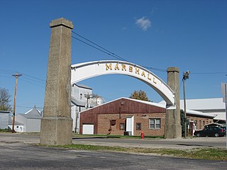
Marshall is a town in Washington Township, Parke County, Indiana, United States. As of the 2010 census, the population was 324.

<span class="mw-page-title-main">Parker City, Indiana</span> Town in Indiana, United States

Parker City is a town in Monroe Township, Randolph County, in the U.S. state of Indiana. The population was 1,419 at the 2010 census.

<span class="mw-page-title-main">Holton, Indiana</span> Town in Indiana, United States

Holton is a town in Otter Creek Township, Ripley County, in the U.S. state of Indiana. The population was 480 at the 2010 census.

<span class="mw-page-title-main">Hudson, Indiana</span> Town in Indiana, United States

Hudson is a town in Salem and Steuben townships, Steuben County, in the U.S. state of Indiana. The population was 518 at the 2010 census.

<span class="mw-page-title-main">Warren Park, Indiana</span> Town in Indiana, United States

Warren Park is a town in Warren Township, Marion County, Indiana, United States. The population was 1,490 at the 2020 census. It has existed as an "included town" since 1970, when it was incorporated into Indianapolis as part of Unigov. It is part of Indianapolis, but retains a functioning town government under IC 36-3-1-11.

References

  1. "2020 U.S. Gazetteer Files". United States Census Bureau. Retrieved March 16, 2022.
  2. 1 2 U.S. Geological Survey Geographic Names Information System: Selma, Indiana
  3. 1 2 "Selma town, Indiana - Census Bureau Profile". Archived from the original on May 2, 2022. Retrieved May 2, 2022.
  4. 1 2 "U.S. Census website". United States Census Bureau . Retrieved January 31, 2008.
  5. Lasley, Norma (2012). Delaware County. Arcadia Publishing. p. 71. ISBN   978-0-7385-9430-9.
  6. "Delaware County". Jim Forte Postal History. Retrieved September 3, 2014.
  7. Kemper, William Harrison (1908). A Twentieth Century History of Delaware County, Indiana, Volume 1. Lewis Publishing Company. p. 166.
  8. "G001 - Geographic Identifiers - 2010 Census Summary File 1". United States Census Bureau. Archived from the original on February 13, 2020. Retrieved July 25, 2015.
  9. "Population Estimates for Indiana's Incorporated Places, 2020-2022". StatsIndiana. Retrieved January 23, 2024.
  10. "Census of Population and Housing". Census.gov. Retrieved June 4, 2015.
  11. "U.S. Census website". United States Census Bureau . Retrieved December 11, 2012.
  12. "Hochman: Hazelbaker is talk of his hometown". St. Louis Post-Dispatch . April 17, 2016.