
USS Darter (SS-227), a Gato-class submarine, was the first ship of the United States Navy to be named for the darter.

Milne Bay is a province of Papua New Guinea. Its capital is Alotau. The province covers 14,345 km² of land and 252,990 km² of sea, within the province there are more than 600 islands, about 160 of which are inhabited. The province has about 276,000 inhabitants, speaking about 48 languages, most of which belong to the Eastern Malayo-Polynesian branch of the Austronesian language family. Economically the province is dependent upon tourism, oil palm, and gold mining on Misima Island; in addition to these larger industries there are many small-scale village projects in cocoa and copra cultivation. The World War II Battle of Milne Bay took place in the province.

Milne Bay is a large bay in Milne Bay Province, south-eastern Papua New Guinea. More than 35 kilometres long and over 15 kilometres wide, Milne Bay is a sheltered deep-water harbor accessible via Ward Hunt Strait. It is surrounded by the heavily wooded Stirling Range to the north and south, and on the northern shore, a narrow coastal strip, soggy with sago and mangrove swamps. The bay is named after Sir Alexander Milne.

Normanby Island is a volcanic, 1,000-square-kilometre (390 sq mi), L-shaped and mountainous island, as well as the southernmost island in the D'Entrecasteaux Islands group. It is part of Milne Bay Province, Papua New Guinea. The island has an irregular and elongated shape measuring 73km in length (northwest-southeast).

Samarai is an island and former administrative capital in Milne Bay Province, Papua New Guinea.
The Ward Hunt Strait is a 30 km wide stretch of water in Milne Bay, separating Papua New Guinea from Goodenough Island in the D'Entrecasteaux Islands. The Dart Reefs and Keast Reef are located in the centre of the channel. The strait was named in honour of George Ward Hunt, First Lord of the Admiralty (1874-1877), by Captain John Moresby.
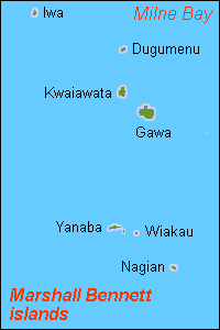
Marshall Bennett Islands are several islands in Milne Bay, Papua New Guinea.

Alotau is the capital of Milne Bay Province, in the south-eastern tip of Papua New Guinea. It is located on the northern shore of Milne Bay and the township is conveniently situated within the Alotau Urban LLG.

Rossel Island is the easternmost island of the Louisiade Archipelago, within the Milne Bay Province of Papua New Guinea. Tree Islet is situated 1.5 miles to the north-west, while Wule Island is situated 1.5 miles westward.

Pocklington Reef is a coral reef and a mostly submerged atoll in the far southeast of Papua New Guinea.

Kitava is one of the four major islands in the Trobriand Islands archipelago group of the Solomon Sea, located in Milne Bay Province of southeastern Papua New Guinea.

The Duchateau Islands are an island group in the Coral Sea, belonging to Papua New Guinea. They lie to the east of Panarairai Island in the Louisiade Archipelago.
Gumawana is an Austronesian language spoken by people living on the Amphlett Islands of the Milne Bay Province of Papua New Guinea.
The Renard Islands are an archipelago in the Solomon Sea. Politically they belong to Milne Bay Province in the southeastern region of Papua New Guinea.
The Strathord Islands are an uninhabited island group of five islands in the Louisiade Archipelago of Papua New Guinea. Politically they belong to the province of Milne Bay in the southeastern region of Papua New Guinea.

Yeina Island is an island of volcanic origin in the Southeast Louisiade Archipelago in Milne Bay Province, Papua New Guinea.

The Jomard Islands are an uninhabited island group in the Coral Sea, belonging to Papua New Guinea, It lies to the east of Montemont Islands in the Louisiade Archipelago.

Bramble Haven is an atoll in the Louisiade Archipelago. Its islands on the northern section are grouped as the Duperre Islands.
Gonubalabala Island (on maps as Gona Bara Bara) is an island on the southern side of East Channel, Milne Bay Province, Papua New Guinea. It is located South east of Logea Island. It is a home island of the Mailulu clan.

The Samarai Islands archipelago, part of the larger Louisiade Archipelago, is located 50 kilometres (31 mi) southeast of mainland New Guinea island, within the nation of Papua New Guinea.
