
Deception Pass is a strait separating Whidbey Island from Fidalgo Island, in the northwest part of the U.S. state of Washington. It connects Skagit Bay, part of Puget Sound, with the Strait of Juan de Fuca. A pair of bridges known collectively as Deception Pass Bridge cross Deception Pass. The bridges were added to the National Register of Historic Places in 1982.

Puget Sound, a sound on the northwestern coast of the U.S. state of Washington, is a complex estuarine system of interconnected marine waterways and basins. A part of the Salish Sea, Puget Sound has one major and two minor connections to the open Pacific Ocean via the Strait of Juan de Fuca—Admiralty Inlet being the major connection and Deception Pass and Swinomish Channel being the minor.

Whidbey Island is the largest of the islands composing Island County, Washington, in the United States, and the largest island in Washington state. Whidbey is about 30 miles (48 km) north of Seattle, and lies between the Olympic Peninsula and the I-5 corridor of western Washington. The island forms the northern boundary of Puget Sound. It is home to Naval Air Station Whidbey Island. The state parks and natural forests are home to numerous old growth trees.

Oak Harbor is a city located on Whidbey Island in Island County, Washington, United States. The population was 22,075 at the 2010 census. Oak Harbor was incorporated on May 14, 1915.
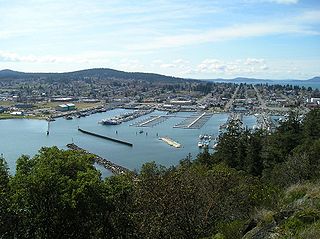
Anacortes is a city in Skagit County, Washington, United States. The name "Anacortes" is an adaptation of the name of Anne Curtis Bowman, who was the wife of early Fidalgo Island settler Amos Bowman. Anacortes' population was 17,637 at the time of the 2020 census. It is one of two principal cities of and included in the Mount Vernon-Anacortes Metropolitan Statistical Area.
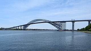
Bayonne Bridge is an arch bridge spanning the Kill Van Kull and connecting Bayonne, New Jersey with Staten Island in New York City. It carries New York State Route 440 (NY 440) and New Jersey Route 440. It has the sixth-longest steel arch mainspan in the world, and this span was the longest in the world at the time of its completion. The bridge is also one of four connecting New Jersey with Staten Island; the other two roadway bridges are the Goethals Bridge in Elizabeth and Outerbridge Crossing in Perth Amboy, and the rail-only span is the Arthur Kill Vertical Lift Bridge, all of which cross the Arthur Kill.

The Skagit River is a river in southwestern British Columbia in Canada and northwestern Washington in the United States, approximately 150 mi (240 km) long. The river and its tributaries drain an area of 1.7 million acres (690,000 hectares) of the Cascade Range along the northern end of Puget Sound and flows into the sound.

Fidalgo Island is an island in Skagit County, Washington, located about 60 mi (97 km) north of Seattle. To the east, it is separated from the mainland by the Swinomish Channel, and from Whidbey Island to the south by Deception Pass. The island is named after the Spanish explorer and cartographer Salvador Fidalgo, who explored the area in 1790.

State Route 20 (SR 20), also known as the North Cascades Highway, is a state highway that traverses the U.S. state of Washington. It is the state's longest highway, traveling 436 miles (702 km) across the northern areas of Washington, from U.S. Route 101 (US 101) at Discovery Bay on the Olympic Peninsula to US 2 near the Idaho state border in Newport. The highway travels across Whidbey Island, North Cascades National Park, the Okanagan Highland, the Kettle River Range, and the Selkirk Mountains. SR 20 connects several major north–south state highways, including Interstate 5 (I-5) in Burlington, US 97 through the Okanogan–Omak area, SR 21 in Republic, and US 395 from Kettle Falls to Colville.
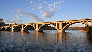
The Francis Scott Key Bridge, more commonly known as the Key Bridge, is a six-lane reinforced concrete arch bridge conveying U.S. Route 29 (US 29) traffic across the Potomac River between the Rosslyn neighborhood of Arlington County, Virginia, and the Georgetown neighborhood of Washington, D.C. Completed in 1923, it is Washington's oldest surviving road bridge across the Potomac River.

The Deer Isle Bridge is a suspension bridge spanning Eggemoggin Reach in the state of Maine. The bridge is the only vehicular connection from the Maine mainland to Little Deer Isle, one of the segments that make up the island. The span was completed in March 1939 with a main span of 1,088 feet (332 m). The bridge was designed by Holton Duncan Robinson and David Bernard Steinman. It encountered wind stability problems that were similar to those of the Whitestone Bridge and the original Tacoma Narrows Bridge, which collapsed shortly after it opened. The problems led to modifications which included numerous cable stays connecting cables to the tower and tower to the deck. The span today carries two narrow lanes of State Route 15.

The South Tenth Street Bridge, most often called the Tenth Street Bridge, but officially dubbed the Philip Murray Bridge, is a suspension bridge that spans the Monongahela River in Downtown Pittsburgh, Pennsylvania.

Padilla Bay is a bay located in the U.S. state of Washington, between the San Juan Islands and the mainland. Fidalgo Island and Guemes Island lie to the west of Padilla Bay. Guemes Channel, between the islands, connects Padilla Bay to Rosario Strait. Samish Island lies to the north of Padilla Bay, beyond which is Samish Bay and Bellingham Bay.

Saratoga Passage lies in Puget Sound between Whidbey Island and Camano Island.

The Lower Skagit are a tribe of the Lushootseed Native American people living in the U.S. state of Washington. Today they are enrolled in the federally recognized tribe, the Swinomish Indians of the Swinomish Reservation.
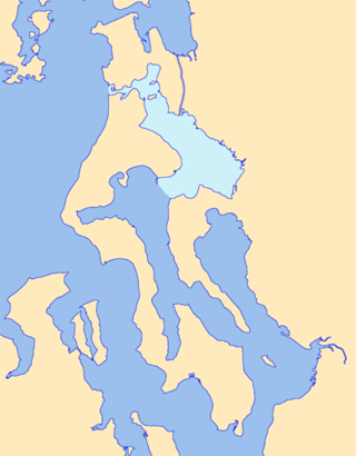
Skagit Bay is a bay and strait located in the U.S. state of Washington. It is part of the Whidbey Island Basin of Puget Sound. The Skagit River empties into Skagit Bay. To the south, Skagit Bay connects with the rest of Puget Sound via Saratoga Passage and Possession Sound. The boundary between Saratoga Passage and Skagit Bay is between Polnell Point on Whidbey Island and Rocky Point on Camano Island. To the northwest, Skagit Bay connects to the Strait of Juan de Fuca via the narrow strait of Deception Pass. A third waterway, the Swinomish Channel, connects Skagit Bay with Padilla Bay to the north.

The 1950 Tacoma Narrows Bridge is a suspension bridge in the U.S. state of Washington that carries the westbound lanes of Washington State Route 16 across the Tacoma Narrows strait, between the city of Tacoma and the Kitsap Peninsula. Opened on October 14, 1950, it was built in the same location as the original Tacoma Narrows Bridge, which collapsed due to a windstorm on November 7, 1940. It is the older of the twin bridges that make up the Tacoma Narrows Bridge crossing of the Tacoma Narrows, and carried both directions of traffic across the strait until 2007. At the time of its construction, the bridge was, like its predecessor, the third-longest suspension bridge in the world in terms of main span length, behind the Golden Gate Bridge and George Washington Bridge; it is now the 46th longest suspension bridge in the world.

The Deception Pass ferry was a ferry route in Washington State that ran between Fidalgo Island and Whidbey Island across Deception Pass.

On May 23, 2013, at approximately 7:00 pm PDT, a span of the bridge carrying Interstate 5 over the Skagit River in the U.S. state of Washington collapsed. Three people in two different vehicles fell into the river below and were rescued by boat, escaping serious injury. The cause of the catastrophic failure was determined to be an oversize load striking several of the bridge's overhead support beams, leading to an immediate collapse of the northernmost span.
The Camano–Whidbey ferry is a historic and proposed ferry route across Saratoga Passage on Puget Sound linking Camano Island and Whidbey Island, the titular islands of Island County, Washington.
 A view of the east side of the bridge
 Looking south towards Canoe pass (foreground) and Deception pass
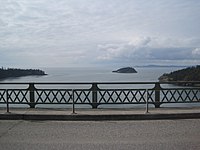 Looking west towards Deception Pass strait from the top of the bridge


