
A minute of arc, arcminute (arcmin), arc minute, or minute arc, denoted by the symbol ′, is a unit of angular measurement equal to 1/60 of one degree. Since one degree is 1/360 of a turn, or complete rotation, one arcminute is 1/21600 of a turn. The nautical mile (nmi) was originally defined as the arc length of a minute of latitude on a spherical Earth, so the actual Earth circumference is very near 21600 nmi. A minute of arc is π/10800 of a radian.
Conversion of units is the conversion of the unit of measurement in which a quantity is expressed, typically through a multiplicative conversion factor that changes the unit without changing the quantity. This is also often loosely taken to include replacement of a quantity with a corresponding quantity that describes the same physical property.

In geography, latitude is a coordinate that specifies the north–south position of a point on the surface of the Earth or another celestial body. Latitude is given as an angle that ranges from −90° at the south pole to 90° at the north pole, with 0° at the Equator. Lines of constant latitude, or parallels, run east–west as circles parallel to the equator. Latitude and longitude are used together as a coordinate pair to specify a location on the surface of the Earth.
Longitude is a geographic coordinate that specifies the east–west position of a point on the surface of the Earth, or another celestial body. It is an angular measurement, usually expressed in degrees and denoted by the Greek letter lambda (λ). Meridians are imaginary semicircular lines running from pole to pole that connect points with the same longitude. The prime meridian defines 0° longitude; by convention the International Reference Meridian for the Earth passes near the Royal Observatory in Greenwich, south-east London on the island of Great Britain. Positive longitudes are east of the prime meridian, and negative ones are west.
A nautical mile is a unit of length used in air, marine, and space navigation, and for the definition of territorial waters. Historically, it was defined as the meridian arc length corresponding to one minute of latitude at the equator, such that Earth's polar circumference is very near to 21,600 nautical miles. Today the international nautical mile is defined as 1,852 metres. The derived unit of speed is the knot, one nautical mile per hour.
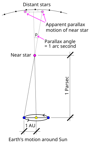
The parsec is a unit of length used to measure the large distances to astronomical objects outside the Solar System, approximately equal to 3.26 light-years or 206,265 astronomical units (AU), i.e. 30.9 trillion kilometres. The parsec unit is obtained by the use of parallax and trigonometry, and is defined as the distance at which 1 AU subtends an angle of one arcsecond. The nearest star, Proxima Centauri, is about 1.3 parsecs from the Sun: from that distance, the gap between the Earth and the Sun spans slightly less than 1/3600 of one degree of view. Most stars visible to the naked eye are within a few hundred parsecs of the Sun, with the most distant at a few thousand parsecs, and the Andromeda Galaxy at over 700,000 parsecs.

The geographic coordinate system (GCS) is a spherical or geodetic coordinate system for measuring and communicating positions directly on the Earth as latitude and longitude. It is the simplest, oldest and most widely used of the various spatial reference systems that are in use, and forms the basis for most others. Although latitude and longitude form a coordinate tuple like a cartesian coordinate system, the geographic coordinate system is not cartesian because the measurements are angles and are not on a planar surface.

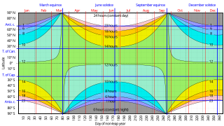
The Tropic of Cancer, also known as the Northern Tropic, is the most northerly circle of latitude on Earth at which the Sun can be directly overhead. This occurs on the June solstice, when the Northern Hemisphere is tilted toward the Sun to its maximum extent. It also reaches 90 degrees below the horizon at solar midnight on the December Solstice. Using a continuously updated formula, the circle is currently 23°26′10.1″ (or 23.43615°) north of the Equator.

A circle of latitude or line of latitude on Earth is an abstract east–west small circle connecting all locations around Earth at a given latitude coordinate line.
In mathematics and computer science, truncation is limiting the number of digits right of the decimal point.
ISO 6709, Standard representation of geographic point location by coordinates, is the international standard for representation of latitude, longitude and altitude for geographic point locations.

The subsolar point on a planet is the point at which its Sun is perceived to be directly overhead ; that is, where the Sun's rays strike the planet exactly perpendicular to its surface. It can also mean the point closest to the Sun on an astronomical object, even though the Sun might not be visible.
The Universal Transverse Mercator (UTM) is a map projection system for assigning coordinates to locations on the surface of the Earth. Like the traditional method of latitude and longitude, it is a horizontal position representation, which means it ignores altitude and treats the earth surface as a perfect ellipsoid. However, it differs from global latitude/longitude in that it divides earth into 60 zones and projects each to the plane as a basis for its coordinates. Specifying a location means specifying the zone and the x, y coordinate in that plane. The projection from spheroid to a UTM zone is some parameterization of the transverse Mercator projection. The parameters vary by nation or region or mapping system.

The gravity of Earth, denoted by g, is the net acceleration that is imparted to objects due to the combined effect of gravitation and the centrifugal force . It is a vector quantity, whose direction coincides with a plumb bob and strength or magnitude is given by the norm .
The sunrise equation or sunset equation can be used to derive the time of sunrise or sunset for any solar declination and latitude in terms of local solar time when sunrise and sunset actually occur.

Geohash is a public domain geocode system invented in 2008 by Gustavo Niemeyer which encodes a geographic location into a short string of letters and digits. Similar ideas were introduced by G.M. Morton in 1966. It is a hierarchical spatial data structure which subdivides space into buckets of grid shape, which is one of the many applications of what is known as a Z-order curve, and generally space-filling curves.
In geodesy and navigation, a meridian arc is the curve between two points on the Earth's surface having the same longitude. The term may refer either to a segment of the meridian, or to its length.
Geographical distance or geodetic distance is the distance measured along the surface of the Earth, or the shortest arch length.
The equator is a circle of latitude that divides a spheroid, such as Earth, into the Northern and Southern hemispheres. On Earth, the Equator is an imaginary line located at 0 degrees latitude, about 40,075 km (24,901 mi) in circumference, halfway between the North and South poles. The term can also be used for any other celestial body that is roughly spherical.
The Bowring series of the transverse mercator published in 1989 by Bernard Russel Bowring gave formulas for the Transverse Mercator that are simpler to program but retain millimeter accuracy.


