National Geospatial-Intelligence Agency

Last updated

National Geospatial-Intelligence Agency
US-NationalGeospatialIntelligenceAgency-2008Seal.svg
Seal of the NGA
Flag of the United States National Geospatial-Intelligence Agency.svg
Flag of the NGA
NGA New HQ.jpg
NGA Campus East, headquarters of the agency
Agency overview
FormedOctober 1, 1996 (1996-10-01)(as the National Imagery and Mapping Agency)
Preceding agency
  • Defense Mapping Agency, Central Imagery Office, and Defense Dissemination Program Office
Headquarters Fort Belvoir, Virginia, U.S. [1]
38°45′12″N77°11′49″W / 38.7532°N 77.1969°W / 38.7532; -77.1969
Motto"Know the Earth, Show the Way... from Seabed to Space"
EmployeesAbout 14,500 [2]
Annual budgetClassified (at least $4.9 billion, as of 2013) [3]
Agency executives
Parent department Department of Defense
Website www.nga.mil
Footnotes
[6]

The National Geospatial-Intelligence Agency (NGA) is a combat support agency within the United States Department of Defense whose primary mission is collecting, analyzing, and distributing geospatial intelligence (GEOINT) in support of national security. Initially known as the National Imagery and Mapping Agency (NIMA) from 1996 to 2003, it is a member of the United States Intelligence Community. [7]

Contents

NGA headquarters, also known as NGA Campus East or NCE, is located at Fort Belvoir North Area in Springfield, Virginia. The agency also operates major facilities in the St. Louis, Missouri area (referred to as NGA Campus West or NCW), as well as support and liaison offices worldwide. The NGA headquarters, at 2,300,000 square feet (210,000 m2), is the third-largest government building in the Washington metropolitan area after The Pentagon and the Ronald Reagan Building. [8]

In addition to using GEOINT for U.S. military and intelligence efforts, NGA provides assistance during natural and artificial disasters, aids in security planning for major events such as the Olympic Games, [9] disseminates maritime safety information, [10] and gathers data on climate change. [11]

The eighth and current director of the agency is Vice Admiral Frank D. Whitworth III. [4]

History

U.S. mapping and charting efforts remained relatively unchanged until World War I, when aerial photography became a major contributor to battlefield intelligence. Using stereo viewers, photo-interpreters reviewed thousands of images. Many of these were of the same target at different angles and times, giving rise to what became modern imagery analysis and mapmaking.

Engineer Reproduction Plant (ERP)

The Engineer Reproduction Plant was the Army Corps of Engineers's first attempt to centralize mapping production, printing, and distribution.[ when? ] It was located on the grounds of the Army War College in Washington, D.C. Previously, topographic mapping had largely been a function of individual field engineer units using field surveying techniques or copying existing or captured products. In addition, ERP assumed the "supervision and maintenance" of the War Department Map Collection, effective April 1, 1939.

Army Map Service (AMS) / U.S. Army Topographic Command (USATC)

With the advent of the Second World War aviation, field surveys began giving way to photogrammetry, photo interpretation, and geodesy. During wartime, it became increasingly possible to compile maps with minimal field work. Out of this emerged AMS, which absorbed the existing ERP in May 1942. It was located at the Dalecarlia Site (including buildings now named for John C. Frémont and Charles H. Ruth) on MacArthur Blvd., just outside Washington, D.C., in Montgomery County, Maryland, and adjacent to the Dalecarlia Reservoir. AMS was designated as an Engineer field activity, effective July 1, 1942, by General Order 22, OCE, June 19, 1942. The Army Map Service also combined many of the Army's remaining geographic intelligence organizations and the Engineer Technical Intelligence Division. AMS was redesignated the U.S. Army Topographic Command (USATC) on September 1, 1968, and continued as an independent organization until 1972, when it was merged into the new Defense Mapping Agency (DMA) and redesignated as the DMA Topographic Center (DMATC) (see below).

Aeronautical Chart Plant (ACP)

After the war, as airplane capacity and range improved, the need for charts grew. The Army Air Corps established its map unit, which was renamed ACP in 1943 and was located in St. Louis, Missouri. ACP was known as the U.S. Air Force Aeronautical Chart and Information Center (ACIC) from 1952 to 1972 (See DMAAC below).

National Photographic Interpretation Center (NPIC)

Seal of the National Photographic Interpretation Center (NPIC) NPIC seal.png
Seal of the National Photographic Interpretation Center (NPIC)

Shortly before leaving office in January 1961, President Dwight D. Eisenhower authorized the creation of the National Photographic Interpretation Center (NPIC), a joint project of the CIA and DIA. NPIC was a component of the CIA's Directorate of Science and Technology (DDS&T) and its primary function was imagery analysis. [12] NPIC became part of the National Imagery and Mapping Agency (now NGA) in 1996. [13]

Directors of NPIC
DirectorTerm of office
Arthur C. Lundahl May 1953 – July 1973
John J. Hicks July 1973 – May 1978
Brigadier Gen. Rutledge P. Hazzard June 1978 – February 1984
Robert M. Huffstutler Feb 1984 – Jan 1988
Frank J. Ruocco February 1988 – February 1991
Leo A. Hazlewood February 1991 – September 1993
Nancy E. Bone October 1993 – September 1996

Cuban Missile Crisis

NPIC first identified the Soviet Union's basing of missiles in Cuba in 1962. By exploiting images from U-2 overflights and film from canisters ejected by orbiting Corona satellites, [14] NPIC analysts developed the information necessary to inform U.S. policymakers and influence operations during the Cuban Missile Crisis. Their analysis garnered worldwide attention when the Kennedy Administration declassified and made public a portion of the images depicting the Soviet missiles on Cuban soil; Adlai Stevenson presented the images to the United Nations Security Council on October 25, 1962.

Defense Mapping Agency (DMA)

The Defense Mapping Agency was created on January 1, 1972, to consolidate all U.S. military mapping activities. DMA's "birth certificate", DoD Directive 5105.40, resulted from a formerly classified Presidential directive, "Organization and Management of the U.S. Foreign Intelligence Community" (November 5, 1971), which directed the consolidation of mapping functions previously dispersed among the military services. [15] DMA became operational on July 1, 1972, pursuant to General Order 3, DMA (June 16, 1972). On October 1, 1996, DMA was folded into the National Imagery and Mapping Agency – which later became NGA. [16]

DMA was first headquartered at the United States Naval Observatory in Washington, D.C, then at Falls Church, Virginia. Its mostly civilian workforce was concentrated at production sites in Bethesda, Maryland, Northern Virginia, and St. Louis, Missouri. DMA was formed from the Mapping, Charting, and Geodesy Division, Defense Intelligence Agency (DIA), and from various mapping-related organizations of the military services. [17]

DMAHC was formed in 1972 when the Navy's Hydrographic Office split its two components: The charting component was attached to DMAHC, and the survey component moved to the Naval Oceanographic Office, Bay St. Louis, Mississippi, on the grounds of what is now the Stennis Space Center. DMAHC was responsible for creating terrestrial maps of coastal areas worldwide and hydrographic charts for DoD. DMAHC was initially located in Suitland, Maryland, but later relocated to Brookmont (Bethesda), Maryland.

DMATC was located in Brookmont (Bethesda), Maryland. It was responsible for creating topographic maps worldwide for DoD. DMATC's location in Bethesda, Maryland is the former site of NGA's headquarters.

DMAHC and DMATC eventually merged to form DMAHTC, with offices in Brookmont (Bethesda), Maryland.

DMAAC originated with the U.S. Air Force's Aeronautical Chart and Information Center (ACIC) and was located in St. Louis, Missouri.

National Imagery and Mapping Agency (NIMA)

US-NationalImageryAndMappingAgency-Logo.svg
US-NationalImageryAndMappingAgency-Seal.svg
Flag of the United States National Imagery and Mapping Agency.svg
NIMA's logo, seal, and flag

NIMA was established on October 1, 1996, by the National Defense Authorization Act for Fiscal Year 1997. [18] The creation of NIMA followed more than a year of study, debate, and planning by the defense, intelligence, and policy-making communities (as well as the Congress) and continuing consultations with customer organizations. The creation of NIMA centralized responsibility for imagery and mapping.

NIMA combined the DMA, the Central Imagery Office (CIO), and the Defense Dissemination Program Office (DDPO) in their entirety, and the mission and functions of the NPIC. Also merged into NIMA were the imagery exploitation, dissemination, and processing elements of the Defense Intelligence Agency, National Reconnaissance Office, and the Defense Airborne Reconnaissance Office.

NIMA's creation was clouded by the natural reluctance of cultures to merge and the fear that their respective missions—mapping in support of defense activities versus intelligence production, principally in support of national policymakers—would be subordinated, each to the other. [19]

NGA

NGA's old headquarters in Brookmont, Maryland prior to 2012. It had been the headquarters of NGA and its predecessor agencies since 1945. After the move to its current headquarters, this facility was renovated and became Intelligence Community Campus-Bethesda. Old National Geospatial-Intelligence Agency Headquarters.png
NGA's old headquarters in Brookmont, Maryland prior to 2012. It had been the headquarters of NGA and its predecessor agencies since 1945. After the move to its current headquarters, this facility was renovated and became Intelligence Community Campus-Bethesda.

With the enactment of the National Defense Authorization Act for Fiscal Year 2004 on November 24, 2003, [20] NIMA was renamed NGA to better reflect its primary mission in the area of GEOINT. [21]

2005 BRAC and Impact on NGA

As a part of the 2005 Base Realignment and Closure (BRAC) process, all major Washington, D.C.–area NGA facilities, including those in Bethesda, Maryland; Reston, Virginia; and Washington, D.C., would be consolidated at a new facility at the Fort Belvoir proving grounds. This new facility, later known as NCE, houses several thousand people and is situated on the former Engineer Proving Ground site near Fort Belvoir. NGA facilities in St. Louis were not affected by the 2005 BRAC process. [22]

The cost of the new center, as of March 2009, was expected to be $2.4 billion. The center's campus is approximately 2,400,000 square feet (220,000 m2) and was completed in September 2011. [23]

Next NGA St. Louis

NGA is currently constructing a new facility in St. Louis, Missouri, Next NGA St. Louis, at a cost of $1.7 billion. The facility is expected to hold 3,000 employees and open by 2025. [24] St. Louis' city legislature is currently reconsidering legislation to surround Next NGA St. Louis with a protection zone that would bar certain businesses, such as gas stations, hazardous material companies, and foreign government-supported enterprises, from building around the site for security purposes. [25]

Organization

Agency structure

Executive Leadership Team

NGA is headed by a director, currently Navy Vice Adm. Frank D. Whitworth; the director is followed in precedence by the deputy director and chief of staff, currently Brett Markham. [26] The holders of these three offices comprise NGA's executive leadership team.

Chief of Staff

While NGA's director and deputy director oversee the agency as a whole, the Chief of Staff is tasked with overseeing NGA's executive support staff, administrative services, logistics, personnel security, human resources, employee training and development, corporate communications, and congressional engagement. [26]

Directorates and directorate leaders

NGA is split into various directorates led by directors (D/XX) and associate deputy directors (ADD/XX) with "XX" standing in for each direcorate's two-letter designation. [26] Known directorates and leadership figures include but are not limited to the:

  • Analysis Directorate, containing the Director of Analytic Operations (D/AO) and Associate Deputy Director for Operational Engagement (ADD/AE) [26] and led by a director, [27] [28] currently Director of Analysis Susan "Sue" Kalweit [29] [30]
  • Source Operations & Management Directorate (S or "Source" Directorate), [31] led by the Director of the Source Operations & Management Directorate [32] or Director of Source Operations [33]
  • Enterprise Operations Directorate (E or "Enterprise" Directorate), led by the Director of the Enterprise Operations Directorate [31]
  • IT Services Directorate [34]
  • Plans and Programs Directorate [27]
  • Research Directorate [35]
  • Security and Installation Operations Directorate [28] (SI) [36]
  • Human Development Directorate (HD) [37]
  • Financial Management Directorate (FM) [38]
  • Unnamed "NGA contracting directorate" [39]
  • Acquisitions Directorate [40]
  • Unnamed "A Directorate" (possibly Acquisitions or Analysis) [40]
  • Unnamed "P Directorate" (possibly Plans and Programs or former Analysis and Production Directorate (see below)) [40]

An Analysis and Production Directorate (P or "Production" Directorate) existed in 2011, [31] although NGA presently has a Directorate for Analysis which may be a replacement or separated portion of the Analysis and Production Directorate. [27]

The deputy associate director of operations directly oversees NGA Operations Center (itself led by a director and deputy director) [26] the Office of NGA Defense, the Office of Expeditionary Operations, and NGA leadership at the three National Reconnaissance Office Aerospace Data facilities. [32]

Other internal groups and leaders

NGA contains NGA Support Teams (NST), which work with directorates, are detailed internationally, deploy with warfighters, or liaise with service branches. [26] [29] [41] Multiple NGA Command NSTs also exist. [42] NGA's western operations, such as the construction of Next NGA St. Louis campus in St. Louis, Missouri, are headed by the NGA St. Louis executive (who can concurrently serve in other leadership roles). [32] There is also an NGA Equality Executive. [33] Other organizations present in NGA, which may or may not be components of directorates, include:

  • NGA Operations Center [26]
  • Office of Expeditionary Operations [32]
  • Office of NGA Defense (OND) [41]
  • Office of the Chief Information Officer (OCIO), led by NGA's Chief Information Officer
  • Office of the Inspector General (OIG), led by NGA's Inspector General (currently Cardell Richardson, Sr.) [33]
  • Records Service Office [31]
  • National Geospatial-Intelligence Committee (GEOCOM), containing subcommittees
  • National Geospatial-Intelligence College (NGC), led by a director
  • GEOINT Enterprise Office, led by a director and organized into branches
  • Office of Geomatics [43]
  • Aeronautical Navigation Office
  • Office of Corporate Assessment and Program Evaluation (CAPE)
  • Office of Corporate Communications, led by a director [29]
  • Office of Strategic Operations-Performance
  • NGA Cyber Security Operations Cell (CSOC), led by a director and organized into teams
  • NGA Police [41]
  • NGA History Department
  • Office of Maritime Safety
    • Bathymetry branch, led by a chief [29]
  • Office of Contract Services [34]
  • Office of Future Warfare Systems (MRF) [44] [45]
  • Office of Diversity Management and Equal Employment Opportunity, led by a director [33]
  • Custom Media Team (XCMS), containing the Tailored Media support team and CMGS (Custom Media Generation System) team [42]
  • GPS Division [46]
  • Historical Imagery Division/Historical Imagery team [47]
  • Volunteered Geographic Information (VGI) Team, community led by NGA containing screened non-NGA users/institutions [48]
  • Office of Ventures and Innovation [49]
  • NGA Research, led by a director
  • Enterprise Innovation Office (EIO)
  • Office of Strategic Operations
  • Office of Geography
  • NGA Outpost Valley (NOV), office of NGA in Silicon Valley [27]
  • Office of Congressional and Intergovernmental Affairs [35]
  • Personnel Security Division, led by a chief [28]
  • Meteorological Operations Center [50]
  • Office of General Counsel (OGC) [37]
  • Records and Declassification Program Office [40]
  • FOIA/Privacy Act Program Office [40] [37]

Additionally, military Service GEOINT Offices (SGOs) liaise with NGA, but belong to their respective military service branches and represent their geospatial intelligence needs. [41] The Canadian Armed Forces deploys a liaison team to NGA; that team's operations officer also acts as NGA's Commonwealth liaison. [29]

NGA is a member of the National System for Geospatial Intelligence (NSG) and the larger Allied System for Geospatial Intelligence (ASG), which includes close allies Canada, the United Kingdom, Australia, and New Zealand. [29] The U.S. and those four nations also form the Five Eyes intelligence alliance. [51]

Employees

NGA employs professionals in aeronautical analysis, cartography, geospatial analysis, imagery analysis, marine analysis, the physical sciences, geodesy, computer and telecommunication engineering, and photogrammetry, as well as those in the national security and law enforcement fields.

List of NIMA / NGA Directors

This table lists all Directors of the NIMA and NGA and their term of office. The agency transitioned from NIMA to NGA during Lieutenant General King's directorship.

No.DirectorTerm
PortraitNameTook officeLeft officeTerm length
1
Joseph J. Dantone.JPEG
Rear Admiral
Joseph J. Dantone
Acting
~October 1996March 1998~1 year, 151 days
2
Portrait of U.S. Army Lt. Gen. James C. King.jpg
Lieutenant General
James C. King
March 1998September 2001~3 years, 184 days
3
James Clapper official Under Secretary portrait.jpg
James Clapper September 2001~July 7, 2006~4 years, 309 days
4
RobertBMurrett.jpg
Vice Admiral
Robert B. Murrett
~July 7, 2006August 2010~4 years, 25 days
5
Letitia Long.jpg
Letitia Long August 2010October 3, 2014~4 years, 63 days
6
Robert Cardillo official photo.jpg
Robert Cardillo October 3, 2014February 7, 20194 years, 127 days
7
Vice Adm. Robert D. Sharp.jpg
Vice Admiral
Robert D. Sharp
February 7, 2019June 3, 20223 years, 116 days
8
Vice Adm. Frank D. Whitworth III (2).jpg
Vice Admiral
Frank D. Whitworth III
June 3, 2022Incumbent1 year, 316 days

Civilian, Department of Defense, and Intelligence Community activities

Controversies

NIMA / NGA has been involved in several controversies.

See also

Related Research Articles

<span class="mw-page-title-main">National Reconnaissance Office</span> US intelligence agency in charge of satellite intelligence

The National Reconnaissance Office (NRO) is a member of the United States Intelligence Community and an agency of the United States Department of Defense which designs, builds, launches, and operates the reconnaissance satellites of the U.S. federal government. It provides satellite intelligence to several government agencies, particularly signals intelligence (SIGINT) to the NSA, imagery intelligence (IMINT) to the NGA, and measurement and signature intelligence (MASINT) to the DIA. The NRO announced in 2023 that it plans within the following decade to quadruple the number of satellites it operates and increase the number of signals and images it delivers by a factor of ten.

<span class="mw-page-title-main">Geospatial intelligence</span> Information on military opponents location

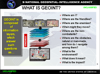
In the United States, geospatial intelligence (GEOINT) is intelligence about the human activity on Earth derived from the exploitation and analysis of imagery, signals, or signatures with geospatial information. GEOINT describes, assesses, and visually depicts physical features and geographically referenced activities on the Earth. GEOINT, as defined in US Code, consists of imagery, imagery intelligence (IMINT) and geospatial information.

The Australian Geospatial-Intelligence Organisation (AGO) is an Australian government intelligence agency that is part of the Department of Defence responsible for the collection, analysis, and distribution of geospatial intelligence (GEOINT) in support of Australia's defence and national interests. The AGO is one of six agencies that form the Australian Intelligence Community.

<span class="mw-page-title-main">Vector Map</span> Vector-based collection of geographic information system (GIS) data about Earth

The Vector Map (VMAP), also called Vector Smart Map, is a vector-based collection of geographic information system (GIS) data about Earth at various levels of detail. Level 0 (low resolution) coverage is global and entirely in the public domain. Level 1 (global coverage at medium resolution) is only partly in the public domain.

<span class="mw-page-title-main">Under Secretary of Defense for Intelligence and Security</span>

The under secretary of defense for intelligence and security or USD(I&S) is a high-ranking civilian position in the Office of the Secretary of Defense (OSD) within the U.S. Department of Defense (DoD) that acts as the principal civilian advisor and deputy to the secretary of defense (SecDef) and deputy secretary of defense (DepSecDef) on matters relating to military intelligence and security. The under secretary is appointed as a civilian by the president and confirmed by the Senate to serve at the pleasure of the president.

The Advanced Technical Intelligence Center for Human Capital Development (ATIC) is a university and industry-focused research, education, and training nonprofit corporation within the Dayton Region. It consolidates technical intelligence education and training in the DoD, national agencies, and civilian institutes and industry.

<span class="mw-page-title-main">Letitia Long</span>

Letitia A. Long served as a civilian in the U.S. Navy and the Intelligence Community between 1978 and 2014, retiring as the fifth Director the National Geospatial-Intelligence Agency, and the first woman to lead a major U.S. intelligence agency, in October 2014. She currently is the Chairman of the Board for the Intelligence and National Security Alliance (INSA).

<span class="mw-page-title-main">Robert Cardillo</span> American intelligence official

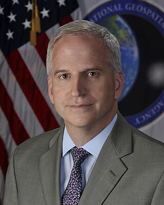
Robert Cardillo is a Distinguished Fellow at Georgetown University’s Center for Security and Emerging Technology. Prior to this appointment, he was the sixth Director of the National Geospatial-Intelligence Agency and was sworn in October 3, 2014. He was previously selected by Director of National Intelligence James Clapper to serve as the first Deputy Director of National Intelligence for Intelligence Integration in September 2010. Clapper said in a statement that the position would "elevate information sharing and collaboration" between those who collect intelligence and those who analyze it. Cardillo previously served as deputy director of the Defense Intelligence Agency (DIA). Prior to that, he served as the deputy director for Analysis, DIA, and Director, Analysis and Production, National Geospatial-Intelligence Agency (NGA).

Geographic information systems (GIS) play a constantly evolving role in geospatial intelligence (GEOINT) and United States national security. These technologies allow a user to efficiently manage, analyze, and produce geospatial data, to combine GEOINT with other forms of intelligence collection, and to perform highly developed analysis and visual production of geospatial data. Therefore, GIS produces up-to-date and more reliable GEOINT to reduce uncertainty for a decisionmaker. Since GIS programs are Web-enabled, a user can constantly work with a decision maker to solve their GEOINT and national security related problems from anywhere in the world. There are many types of GIS software used in GEOINT and national security, such as Google Earth, ERDAS IMAGINE, GeoNetwork opensource, and Esri ArcGIS.

The Defence Intelligence Fusion Centre (DIFC) is based at RAF Wyton in Cambridgeshire. Largely created from the staff of the National Imagery Exploitation Centre and then known for several years as the Defence Geospatial Intelligence Fusion Centre, it can trace its history back to clandestine reconnaissance operations at the beginning of the Second World War by Sydney Cotton on behalf of MI6 and then MI4, and the formation of the Allied Central Interpretation Unit at RAF Medmenham.

<span class="mw-page-title-main">Robert M. Huffstutler</span> Former US intelligence service director

Robert M. Huffstutler was director of National Photographic Interpretation Center from February 1984 to January 1988.

<span class="mw-page-title-main">Nancy E. Bone</span> Former US intelligence service director

Nancy E. Bone is an American former intelligence officer who served as Director of National Photographic Interpretation Center between October 1993 and September 1996.

<span class="mw-page-title-main">Frank J. Ruocco</span>

Frank J. Ruocco was fifth director of National Photographic Interpretation Center (NPIC) from February 1988 to February 1991.

<span class="mw-page-title-main">Leo A. Hazlewood</span> Imagery and mapping

Leo A. Hazlewood was Director of National Photographic Interpretation Center from February 1991 – September 1993), and Deputy Director of National Imagery and Mapping Agency from July 1997 – January 2000. He also served as Deputy Director of Operations at National Imagery and Mapping Agency.

<span class="mw-page-title-main">Joseph J. Dantone</span> Former senior officer in the U.S. Navy

Rear Admiral Joseph John "Jack" Dantone Jr. of U.S. Navy, was last director of Defense Mapping Agency (DMA) from May 1996 to September 1996. He was also the Acting Director of National Imagery and Mapping Agency (NIMA) from October 1996 to March 1998. He played a major role in transition of DMA into NIMA.

<span class="mw-page-title-main">James C. King</span> United States Army general

James C. King is a retired United States Army Lieutenant General. A career Military Intelligence officer, he served on active duty from 1968 to 2001. At the time of his retirement he was serving as the Director of the National Imagery and Mapping Agency, one of the intelligence agencies of the United States Intelligence Community.

<span class="mw-page-title-main">Shannon D. Cramer</span> Former senior officer in the United States Navy

Shannon D. Cramer Jr. was a United States Navy vice sdmiral. He was second director of the Defense Mapping Agency from September 1974 to August 1977. From April to September 1974, he was deputy director for plans, Defense Intelligence Agency.

<span class="mw-page-title-main">Justin Poole</span> US government official

Justin Poole was the seventh deputy director of the National Geospatial-Intelligence Agency (NGA). As deputy director of NGA, he assisted the director in leading the agency and managing the day-to-day operations of NGA and the National System for Geospatial-Intelligence. He became the deputy director on August 10, 2017, after more than 28 years of service with NGA and its predecessor organizations. He resigned on June 11, 2019, following a Department of Defense probe into allegations of personal misconduct.

All-source intelligence is a term used to describe intelligence organizations, intelligence analysts, or intelligence products that are based on all available sources of intelligence collection information.

<span class="mw-page-title-main">Geospatial Intelligence Battalion</span> Military unit

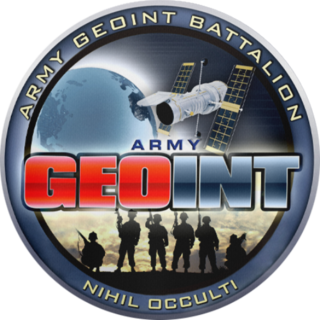
The United States Army Geospatial Intelligence Battalion, previously known as the 3rd Military Intelligence Center, is a military intelligence battalion specializing in the production and exploitation of geospatial intelligence (GEOINT), and the only operational military command at the National Geospatial-Intelligence Agency (NGA). Co-located within the NGA headquarters (NGA-East) on Fort Belvoir in Springfield, Virginia, the unit produces and analyzes geospatial intelligence products for ground combat forces in close collaboration with its host agency and other members of the U.S. Intelligence Community. Though colocated with NGA, the AGB differs from NGA's own Support Teams in that it receives tasking from the Army.

References

  1. "NGA Campus East Fact Sheet" (PDF). Archived from the original (PDF) on February 21, 2014.
  2. "About NGA". National Geospatial-Intelligence Agency. Retrieved May 23, 2021.
  3. Gellman, Barton; Greg Miller (August 29, 2013). "U.S. spy network's successes, failures and objectives detailed in 'black budget' summary". The Washington Post. Retrieved August 29, 2013.
  4. 1 2 "United States Navy Flag Officers (Public), June 2022" (PDF). MyNavyHR. Archived from the original (PDF) on June 1, 2022. Retrieved June 2, 2022.
  5. "About NGA". National Geospatial-Intelligence Agency. August 5, 2021. Archived from the original on August 5, 2021.
  6. "GSP - GSP". www.esa.int.
  7. "10 U.S. Code § 441 - Establishment". LII / Legal Information Institute.
  8. Serbu, Jared (September 27, 2011). "Geospatial intelligence HQ is now DC's 3rd largest federal office building". Federal News Radio. Retrieved March 19, 2016.
  9. "About NGA". Archived from the original on October 6, 2014.
  10. "Maritime Safety Information". msi.nga.mil. Retrieved October 23, 2021.
  11. Perez, Lisbeth (June 3, 2021). "NGA Crunching Climate Change Data for National Security Decision-Making". MeriTalk. Retrieved June 30, 2021.
  12. "Thirty ... and thriving". Central Intelligence Agency. December 1, 1991. p. 1ff. Archived from the original on March 8, 2012. Retrieved May 30, 2010.
  13. "Jan. 18, 1961: National Photographic Interpretation Center". www.nga.mil. Archived from the original on July 2, 2019. Retrieved August 9, 2017.
  14. 1 2 NGA History Archived March 20, 2009, at the Wayback Machine , nga.mil
  15. Nixon, Richard (November 5, 1971). "Memorandum, Subject: Organization and Management of the U.S. Foreign Intelligence Community" (PDF). gwu.edu. Retrieved August 12, 2007.
  16. "Defense Mapping Agency". NGA.mil. Archived from the original on July 2, 2019. Retrieved March 8, 2016.
  17. U.S. National Archives. "Guide to Federal Records: Records of the Defense Mapping Agency (DMA)". National Archives and Records Administration (NARA). Retrieved August 12, 2007.
  18. "National Defense Authorization Act for Fiscal Year 1997" (PDF). GovInfo. September 23, 1996. Retrieved February 10, 2008.
  19. "The Information Edge: Imagery Intelligence and Geospatial Information in an Evolving National Security Environment (Report of the Independent Commission on the NIMA)" (PDF). National Geospatial-Intelligence Agency. December 2000. Archived from the original (PDF) on September 19, 2009.
  20. "National Defense Authorization Act for Fiscal Year 2004" (PDF). GovInfo. November 24, 2003. Retrieved February 10, 2008.
  21. "Pathfinder" (PDF). NGA. September–October 2003. Archived from the original (PDF) on September 19, 2009.
  22. "New Campus East". National Geospatial-Intelligence Agency. Archived from the original on November 5, 2009.
  23. Davenport, Christian, "Projects' Costs Are Rising", The Washington Post, March 31, 2009, p. B4
  24. Bernthal, Jeff (June 7, 2021). "Progress visible at Next NGA St. Louis site in north St. Louis". Fox2Now. Retrieved June 29, 2021.
  25. Ryan, Monica (June 29, 2021). "'Protection' district being reconsidered around NGA site". Fox2Now. Retrieved June 30, 2021.
  26. 1 2 3 4 5 6 7 "Brett Markham, Chief of Staff". National Geospatial-Intelligence Agency. Retrieved July 9, 2021.
  27. 1 2 3 4 "Pathfinder Vol. 14 No. 2" (PDF). NGA Pathfinder. National Geospatial-Intelligence Agency. 2016. Retrieved July 11, 2021.
  28. 1 2 3 "Investigative Summaries for 26 National Geospatial-Intelligence Agency (NGA) Office of Inspector General (OIG) investigative cases, 2008-2010" (PDF). Government Attic. Retrieved July 11, 2021.
  29. 1 2 3 4 5 6 "Pathfinder Vol. 15 No. 1" (PDF). NGA Pathfinder. National Geospatial-Intelligence Agency. 2017. Retrieved July 9, 2021.
  30. "Susan Kalweit" (PDF). insaonline.org. Intelligence and National Security Alliance . Retrieved August 13, 2021.
  31. 1 2 3 4 Management of Hard Copy Mapping Products in the National Geospatial-Intelligence Agency Inspection Report (PDF) (Report). National Archives and Records Administration. June 2011. Retrieved July 9, 2021.
  32. 1 2 3 4 "NGA appoints agency's new west executive, deputy associate director for operations". National Geospatial-Intelligence Agency. Retrieved July 9, 2021.
  33. 1 2 3 4 "Inspector General". National Geospatial-Intelligence Agency. Retrieved July 11, 2021.
  34. 1 2 "Pathfinder Vol. 14 No. 3" (PDF). NGA Pathfinder. National Geospatial-Intelligence Agency. 2016. Retrieved July 9, 2021.
  35. 1 2 "DNI HAINES STATEMENT ON THE PRESIDENT'S INTENT TO NOMINATE DR. STACEY DIXON AS PDDNI" (Press release). ODNI. April 21, 2021. Retrieved July 11, 2021.
  36. "National Geospatial-Intelligence Agency (NGA) Legal Guide: Legal Considerations on the Proper Collection and Use of Social Media Information, 2012" (PDF). Government Attic. Retrieved July 11, 2021.
  37. 1 2 3 "National Geospatial-Intelligence Agency (NGA) Instruction (NI) 1000.7R1: NGA Instruction for Personal Relationships in the Workplace, 2004" (PDF). Government Attic. Retrieved July 11, 2021.
  38. "National Geospatial-Intelligence Agency (NGIA) Office of Inspector General (OIG) Assessment of Management and Performance Challenges for FY 2007 to 2013 Agency Financial Reports" (PDF). Government Attic. Retrieved July 11, 2021.
  39. "National Geospatial-Intelligence Agency (NGA) response to a Congressional request for "agency"-specific information on climate change, 2013" (PDF). Government Attic. Retrieved July 11, 2021.
  40. 1 2 3 4 5 "National Geospatial-Intelligence Agency (NGA) Records Storage Study, Final Results, 2006" (PDF). Government Attic. Retrieved July 11, 2021.
  41. 1 2 3 4 "Pathfinder Vol. 14 No. 4" (PDF). NGA Pathfinder. National Geospatial-Intelligence Agency. 2016. Retrieved July 9, 2021.
  42. 1 2 "Custom Media Team". National Geospatial-Intelligence Agency. Retrieved July 11, 2021.
  43. https://earth-info.nga.mil/.{{cite web}}: Missing or empty |title= (help)
  44. Deputy Under Secretary of Defense for Acquisition and Technology (March 2, 2007). "Format Changes for the Defense Acquisition Executive Summary (DAES) Reviews" (PDF). acq.osd.mil. Defense Department . Retrieved July 11, 2021.
  45. "GEOINT Standards & Architecture Expert - TS/SCI". appone.com. Appone. Retrieved July 11, 2021.
  46. "GPS and Earth Orientation Products". National Geospatial-Intelligence Agency. Retrieved July 11, 2021.
  47. "Historical Maps and Charts". National Geospatial-Intelligence Agency. Retrieved July 11, 2021.
  48. "NOME". National Geospatial-Intelligence Agency. Retrieved July 11, 2021.
  49. Wilson, Samuel (July 24, 2017). "NGA Office of Ventures and Innovation explained". National Geospatial-Intelligence Agency. Retrieved July 11, 2021.
  50. Uhler, Carling (February 9, 2016). "Amidst a blizzard, NGA workforce maintains facilities, mission support". NG Office of Corporate Communications. Retrieved July 11, 2021.
  51. "Five Eyes Intelligence Oversight and Review Council (FIORC)". dni.gov. Director of National Intelligence.
  52. Ambinder, Marc (May 5, 2011). "The Little-Known Agency That Helped Kill Bin Laden". The Atlantic Monthly.
  53. "Osama bin Laden Compound Raid". National Geospatial-Intelligence Agency. Archived from the original on May 23, 2017. Retrieved July 27, 2017.PD-icon.svg This article incorporates text from this source, which is in the public domain .
  54. 1 2 "Oakland emails give another glimpse into the Google-Military-Surveillance Complex". PandoDaily. March 7, 2014. Archived from the original on August 19, 2015. Retrieved March 28, 2014.
  55. Geospatial Intelligence Aids Hurricane Recovery Efforts Archived September 19, 2009, at the Wayback Machine , nga.mil
  56. Microsoft and NGA Announce Strategic Alliance Archived June 17, 2006, at the Wayback Machine , microsoft.com
  57. NGA releases open source code on GitHub Archived April 13, 2016, at the Wayback Machine , FierceGovernmentIT, April 07, 2014
  58. "» GEOINT 2013* – Keynote Letitia A. Long - USGIF official video portal". July 30, 2017. Archived from the original on July 30, 2017.
  59. "National Geospatial-Intelligence Agency". GitHub.
  60. Sparks, Carolyn (March 4, 2021). "NGA Director Sharp inducts newest Space Force officers". National Geospatial-Intelligence Agency. Retrieved May 22, 2021.
  61. Birnbaum, Michael (January 2, 2023). "Why the U.S. is enlisting a spy agency during hurricanes". Washington Post . washingtonpost.com. Retrieved January 2, 2023.
  62. "NGA contributes to State Department-supported effort to document potential war crimes, other atrocities in Ukraine". National Geospatial-Intelligence Agency. July 11, 2022. Retrieved January 12, 2023.
  63. "Secretive map agency opens its doors" Archived October 22, 2006, at the Wayback Machine , CNN.com, December 13, 2002
  64. DCI Statement on the Belgrade Chinese Embassy Bombing to a House Permanent Select Committee on Intelligence Open Hearing, 22 July 1999 Archived June 13, 2007, at the Wayback Machine , CIA
  65. "USS Guardian Grounding Investigation Results Released". U.S. Navy. Archived from the original on June 22, 2013. Retrieved June 20, 2013.
  66. Hill, Kashmir (January 9, 2019). "How Cartographers for the U.S. Military Inadvertently Created a House of Horrors in South Africa". Gizmodo. Retrieved January 10, 2019.
  67. Stirone, Shannon (September 7, 2018). "New Antarctica Map Is Like 'Putting on Glasses for the First Time and Seeing 20/20' – A high resolution terrain map of Earth's frozen continent will help researchers better track changes on the ice as the planet warms". The New York Times . Retrieved September 9, 2018.

Further reading