
Chesapeake is an independent city in the Commonwealth of Virginia. As of the 2020 census, the population was 249,422, it is the second-most populous city in Virginia, tenth-largest in the Mid-Atlantic, and the 90th most populous city in the United States.

Elizabeth City is a city in Pasquotank County, North Carolina, United States. As of the 2010 census, it had a population of 18,683. Elizabeth City is the county seat and largest city of Pasquotank County. It is the cultural, economic and educational hub of the sixteen-county Historic Albemarle region of northeastern North Carolina.

The Elizabeth River is a 6-mile-long (10 km) tidal estuary forming an arm of Hampton Roads harbor at the southern end of Chesapeake Bay in southeast Virginia in the United States. It is located along the southern side of the mouth of the James River, between the cities of Portsmouth, Norfolk, and Chesapeake. Forming the core of the Hampton Roads harbor, it is heavily supported by its tributaries which depend upon it.
The Hampton Roads Beltway is a loop of Interstate 64 and Interstate 664, which links the communities of the Virginia Peninsula and South Hampton Roads which surround the body of water known as Hampton Roads and comprise much of the region of the same name in the southeastern portion of Virginia in the United States. It crosses the harbor of Hampton Roads at two locations on large four-laned bridge-tunnel facilities: the eastern half carries Interstate 64 and uses the Hampton Roads Bridge-Tunnel and the western half carries Interstate 664 and uses the Monitor-Merrimac Memorial Bridge-Tunnel. The beltway has the clockwise direction signed as the Inner Loop, and the counter-clockwise direction signed as the Outer Loop. The entire beltway, including the bridge-tunnels, is owned and operated by the Virginia Department of Transportation.

South Hampton Roads is a region located in the extreme southeastern portion of Virginia's Tidewater region in the United States with a total population of 1,191,937. It is part of the Virginia Beach-Norfolk-Newport News, VA-NC MSA, which itself has a population of 1,724,876.

The Great Dismal Swamp is a large swamp in the Coastal Plain Region of southeastern Virginia and northeastern North Carolina, between Norfolk, Virginia, and Elizabeth City, North Carolina. It is located in parts of the southern Virginia independent cities of Chesapeake and Suffolk and northern North Carolina counties of Gates, Pasquotank, and Camden. Some estimates place the size of the original swamp at over one million acres (4,000 km2).

The Great Dismal Swamp National Wildlife Refuge was created in 1974 to help protect and preserve a portion of the Great Dismal Swamp, a marshy region on the Coastal Plain of southeastern Virginia and northeastern North Carolina between Norfolk, Virginia, and Elizabeth City, North Carolina in the United States. It is located in parts of the independent cities of Chesapeake and Suffolk in Virginia, and the counties of Camden, Gates, and Pasquotank in North Carolina.
Interstate 264 (I-264) is an Interstate Highway in the U.S. state of Virginia. It serves as the primary east-west highway through the South Hampton Roads region in southeastern Virginia. The route connects the central business districts of Chesapeake, Portsmouth, Norfolk, and Virginia Beach and serves as the most direct link between those cities and the resort beaches along Virginia's Atlantic coast.

Norfolk County was a county of the South Hampton Roads in eastern Virginia in the United States that was created in 1691. After the American Civil War, for a period of about 100 years, portions of Norfolk County were lost and the territory of the county reduced as they were annexed by the independent and growing cities of Norfolk, Portsmouth and South Norfolk.

Bower's Hill is a community located in the independent city of Chesapeake, Virginia in the United States. It is located in the South Hampton Roads region at the northeastern edge of the Great Dismal Swamp, an area consisting of generally low-lying sandy terrain of the coastal plain.
The Dismal Swamp Canal is located along the eastern edge of the Great Dismal Swamp in Virginia and North Carolina in the United States. It is the oldest continually operating man-made canal in the United States, opened in 1805. It is part of the Intracoastal Waterway.
Transportation in the Commonwealth of Virginia is by land, sea and air. Virginia's extensive network of highways and railroads were developed and built over a period almost 400 years, beginning almost immediately after the founding of Jamestown in 1607, and often incorporating old established trails of the Native Americans.
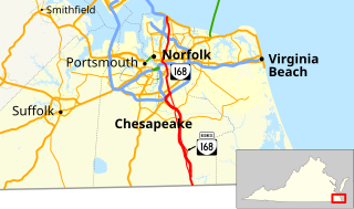
State Route 168 is a primary state highway in the South Hampton Roads region of the U.S. state of Virginia. It runs from the border with North Carolina through the independent cities of Chesapeake and Norfolk where it ends in the Ocean View area near the Hampton Roads Bridge-Tunnel.

The Jordan Bridge, officially named the South Norfolk Jordan Bridge, is a tolled highway fixed bridge which carries State Route 337 over the Southern Branch Elizabeth River between the City of Portsmouth into the City of Chesapeake in South Hampton Roads, Virginia. The new crossing is an all-electronic toll facility that eliminated bridge lifts and height and weight restrictions and restored a vital river crossing for the Hampton Roads region.
Ocean Highway was a designation established early in the 20th century for a combination of roadways and water-crossings for motor vehicles which would generally traverse as close as possible to the Atlantic Ocean along the East Coast of the United States from Jacksonville, Florida to North Brunswick, New Jersey. The Ocean Highway concept predated the creation of the Interstate Highway System beginning in the 1950s, and in many states the highways and byways of coastal routes from Florida to North Brunswick still carry the name.

U.S. Route 17 is a part of the U.S. Highway System that runs from Punta Gorda, Florida to Winchester, Virginia. In Virginia, the U.S. Highway runs 255.83 miles (411.72 km) from the North Carolina state line in Chesapeake north to its northern terminus at US 11, US 50, and US 522 in Winchester. US 17 is a major highway in the eastern half of Virginia. The U.S. Highway connects the Albemarle Region of North Carolina with the Hampton Roads metropolitan area. Within the urban area, US 17 passes through the South Hampton Roads cities of Chesapeake, Portsmouth, and Suffolk and the Virginia Peninsula city of Newport News. Between Yorktown and Fredericksburg, the U.S. Highway serves as the primary highway of the Middle Peninsula. At Fredericksburg, US 17 leaves the Atlantic coastal plain; the highway passes through the Piedmont town of Warrenton and crosses the Blue Ridge Mountains on its way to Winchester in the Shenandoah Valley.The route from Tappahannock to Winchester roughly follows the Confederate March during the Civil War to Gettysburg.

State Route 165 is a primary state highway in the U.S. state of Virginia. The state highway runs 39.75 miles (63.97 km) from U.S. Route 17 Business in Chesapeake north to SR 337 in Norfolk. SR 165 is a C-shaped route that connects Chesapeake and Norfolk in the Hampton Roads metropolitan area indirectly via Virginia Beach. The highway's east–west segment connects the Chesapeake communities of Deep Creek and Great Bridge with the Princess Anne part of Virginia Beach. SR 165's northwest–southeast portion connects the Princess Anne area with Virginia Beach's Salem and Kempsville communities and with Norfolk. Within Norfolk, the state highway parallels Interstate 64 (I-64) while passing through the eastern and northern areas of the city near Norfolk International Airport and Naval Station Norfolk. Much of SR 165 is a multi-lane divided highway, but there are significant two-lane stretches in all three of the independent cities the highway serves.
Whaleyville is a neighborhood of Suffolk, Virginia, United States. It was formerly an incorporated town located in southern Nansemond County, Virginia. Whaleyville is located midway between the former county seat at downtown Suffolk and the North Carolina border along U.S. Route 13.

In 1963, the new independent city of Chesapeake was created when the former independent city of South Norfolk consolidated with Norfolk County. The consolidation, authorized by the Virginia General Assembly, was approved and the new name selected by the voters of each communities by referendum. The new city is part of the current region of Hampton Roads which are linked by the circumferential Hampton Roads Beltway.
Interstate 87 (I-87) is a partially completed Interstate Highway in the U.S. state of North Carolina, currently the shortest designated primary Interstate Highway at 12.9 miles (20.8 km). The completed portion is in eastern Wake County, between Raleigh and Wendell; the majority of the completed route is known as the Knightdale Bypass, while the remaining 3 miles (4.8 km) follows the Raleigh Beltline. It is planned to continue northeast through Rocky Mount, Williamston and Elizabeth City, ending in Norfolk, Virginia. It is signed as north-south, in keeping with the sign convention for most odd-numbered interstates, but the route goes primarily east-west, with the eastern direction aligning to the north designation. The entire route is concurrent with US 64, with portions also concurrent with I-440 and US 264.


