Whitefish Township is a civil township of Chippewa County in the U.S. state of Michigan. The population was 575 at the 2010 census.

Bradford is the primary country urban area of the Town of Bradford West Gwillimbury, Ontario, in Canada. It overlooks a farming community, known as The Holland Marsh, located on the Holland River that flows into Lake Simcoe.
Blind River is a town situated on the North Channel of Lake Huron in the Algoma District, Ontario, Canada. The town, named after the nearby Blind River, celebrated its centennial in 2006.

Interlochen, is an unincorporated community and census-designated place (CDP) in Green Lake Township, Grand Traverse County, Michigan, United States. As of the 2010 census, the Interlochen census-designated place (CDP) had a population of 583.

Grand Marais is an unincorporated community in Alger County in the U.S. state of Michigan. It is located within Burt Township on the shores of Lake Superior, and the community is the eastern gateway to the Pictured Rocks National Lakeshore via H-58.

Biscotasing, often referred to as simply Bisco, is a community in the Unorganized North Part of Sudbury District in Northeastern Ontario, Canada. It was founded on the shores of Lake Biscotasi on the Spanish River in 1884 by Canadian Pacific Railway as a railway construction town, and the first divisional point west of Sudbury. The rails of westward track laying gangs reached this area in October 1884.

Crisp Point was one of five U.S. Life-Saving Service Stations along the coast of Lake Superior between Munising and Whitefish Point in the Upper Peninsula of Michigan. The lighthouse is within McMillan Township in Luce County.

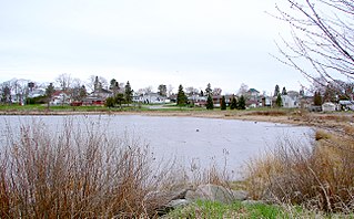
Muskallonge Lake State Park is a public recreation area on Lake Superior sixteen miles (26 km) east of Grand Marais in Luce County, Michigan. The state park covers 217 acres (88 ha) between the shores of Lake Superior and Muskallonge Lake where Native American's once had an encampment and where a station of the United States Life-Saving Service once stood.

Algoma is an unincorporated community on the east shore of Upper Klamath Lake, in Klamath County, Oregon, United States. It is about 8 miles (13 km) north of the city of Klamath Falls on U.S. Route 97. Algoma was named for the Algoma Lumber Company.

Pequaming is an unincorporated community in L'Anse Township of Baraga County in the U.S. state of Michigan. It is located on a narrow point of land that juts into Keweenaw Bay. Although still partially inhabited, Pequaming is one of the largest ghost towns in the Upper Peninsula of Michigan.

Lumberman's Monument is a monument dedicated to the workers of the early logging industry in Michigan. Standing at 14 feet, the bronze statue features a log surrounded by three figures: a timber cruiser holding a compass, a sawyer with his saw slung over his shoulder, and a river rat resting his peavey on the ground. The granite base of the statue is engraved with a memorial that reads "Erected to perpetuate the memory of the pioneer lumbermen of Michigan through whose labors was made possible the development of the prairie states." It is also inscribed with the names of the logging families who dedicated their time and efforts to the industry in the area. It was built in 1931, dedicated in 1932 and is managed by the USDA Forest Service. It is located in the northeastern part of the Lower Peninsula of Michigan along the Au Sable River within Huron-Manistee National Forests. Access to the park is on River Road, which intersects M-65 west of Oscoda, Michigan. Monument Road, from East Tawas, also leads directly to the monument, which is in Oscoda Township in Iosco County. The monument is part of the River Road Scenic Byway, a 22-mile (35 km) drive between Oscoda and South Branch that runs parallel with the beautiful Au Sable River. It is a designated National Scenic Byway.

Laona is an unincorporated census-designated place in the town of Laona in Forest County, Wisconsin, United States. U.S. Route 8 travels east–west through the community and Wisconsin Highway 32 travels south and west of the community. The community park has a sign stating that the community donated the 1979 Christmas tree at the nation's capitol. As of the 2010 census, its population is 583.
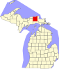
Shelldrake is a ghost town in Whitefish Township, Chippewa County, Michigan, United States, about 8 miles (13 km) south of Whitefish Point, Michigan at the mouth of the Shelldrake River on Whitefish Bay. It is listed on the Michigan Historic Register. Prior to European settlement it supported a seasonal Native American fishing village. In the 1890s and early 1900s, it was a thriving sawmill town during peak logging years on the Tahquamenon River watershed. By the 1920s repeated fires and the decline of lumbering led to its demise. Today it is a privately owned ghost town with only a few weathered, original buildings.

Pino Grande is an unincorporated community in El Dorado County, California. It is located 8 miles (13 km) north-northwest of Pollock Pines, at an elevation of 4022 feet.

Pine Stump Junction is an unincorporated community in Luce County in the U.S. state of Michigan. The community is located within McMillan Township. As an unincorporated community, Pine Stump Junction has no legally defined boundaries or population statistics of its own.

Wabeno is an unincorporated census-designated place located within the town of Wabeno, in Forest County, Wisconsin, United States. It is located on Wisconsin Highway 32 at the eastern terminus of Wisconsin Highway 52 within the Nicolet National Forest. As of the 2010 census, its population is 575.

McMillan Township is a civil township of Luce County in the U.S. state of Michigan. The population was 2,692 at the 2010 census. At 588.78 square miles (1,524.9 km2) of total land area, McMillan Township occupies 65.5% of Luce County's land area and is also the largest municipality by area in the state of Michigan.

Kennedy is an unincorporated community located in the town of Lake, Price County, Wisconsin, United States. Once a busy sawmill community during the logging boom, Kennedy is now a ghost town.
Morse is an unincorporated community located in the town of Gordon, Ashland County, Wisconsin, United States. Morse is located along the Bad River 7.5 miles (12.1 km) south-southeast of Mellen.
Muskallonge Lake is a 780-acre (320 ha) lake in Luce County in the Upper Peninsula of the U.S. state of Michigan. Approximately 1.9 miles (3,100 m) long and .8 miles (1,300 m) wide, it is separated from Lake Superior to the north by a quarter-mile-wide strip of land that is the site of Muskallonge Lake State Park. Relatively shallow, the lake's deepest point is 20 feet (6.1 m) below the water surface. The lake sits at 630 feet (190 m) above sea level, thirty feet (9.1 m) above Lake Superior.