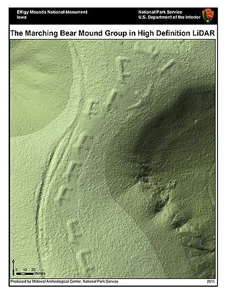
Lidar is a method for determining ranges by targeting an object or a surface with a laser and measuring the time for the reflected light to return to the receiver. Lidar may operate in a fixed direction or it may scan multiple directions, in which case it is known as lidar scanning or 3D laser scanning, a special combination of 3-D scanning and laser scanning. Lidar has terrestrial, airborne, and mobile applications.
Instrumentation is a collective term for measuring instruments, used for indicating, measuring and recording physical quantities. It is also a field of study about the art and science about making measurement instruments, involving the related areas of metrology, automation, and control theory. The term has its origins in the art and science of scientific instrument-making.
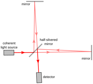
Interferometry is a technique which uses the interference of superimposed waves to extract information. Interferometry typically uses electromagnetic waves and is an important investigative technique in the fields of astronomy, fiber optics, engineering metrology, optical metrology, oceanography, seismology, spectroscopy, quantum mechanics, nuclear and particle physics, plasma physics, biomolecular interactions, surface profiling, microfluidics, mechanical stress/strain measurement, velocimetry, optometry, and making holograms.
Subsidence is a general term for downward vertical movement of the Earth's surface, which can be caused by both natural processes and human activities. Subsidence involves little or no horizontal movement, which distinguishes it from slope movement.

A strain gauge is a device used to measure strain on an object. Invented by Edward E. Simmons and Arthur C. Ruge in 1938, the most common type of strain gauge consists of an insulating flexible backing which supports a metallic foil pattern. The gauge is attached to the object by a suitable adhesive, such as cyanoacrylate. As the object is deformed, the foil is deformed, causing its electrical resistance to change. This resistance change, usually measured using a Wheatstone bridge, is related to the strain by the quantity known as the gauge factor.

A data logger is an electronic device that records data over time or about location either with a built-in instrument or sensor or via external instruments and sensors. Increasingly, but not entirely, they are based on a digital processor, and called digital data loggers (DDL). They generally are small, battery-powered, portable, and equipped with a microprocessor, internal memory for data storage, and sensors. Some data loggers interface with a personal computer and use software to activate the data logger and view and analyze the collected data, while others have a local interface device and can be used as a stand-alone device.

Laser Doppler velocimetry, also known as laser Doppler anemometry, is the technique of using the Doppler shift in a laser beam to measure the velocity in transparent or semi-transparent fluid flows or the linear or vibratory motion of opaque, reflecting surfaces. The measurement with laser Doppler anemometry is absolute and linear with velocity and requires no pre-calibration.

Satellite geodesy is geodesy by means of artificial satellites—the measurement of the form and dimensions of Earth, the location of objects on its surface and the figure of the Earth's gravity field by means of artificial satellite techniques. It belongs to the broader field of space geodesy. Traditional astronomical geodesy is not commonly considered a part of satellite geodesy, although there is considerable overlap between the techniques.
Weigh-in-motion or weighing-in-motion (WIM) devices are designed to capture and record the axle weights and gross vehicle weights as vehicles drive over a measurement site. Unlike static scales, WIM systems are capable of measuring vehicles traveling at a reduced or normal traffic speed and do not require the vehicle to come to a stop. This makes the weighing process more efficient, and, in the case of commercial vehicles, allows for trucks under the weight limit to bypass static scales or inspection.
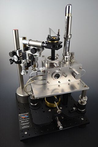
The Surface Force Apparatus (SFA) is a scientific instrument which measures the interaction force of two surfaces as they are brought together and retracted using multiple beam interferometry to monitor surface separation and directly measure contact area and observe any surface deformations occurring in the contact zone. One surface is held by a cantilevered spring, and the deflection of the spring is used to calculate the force being exerted. The technique was pioneered by David Tabor and R.H.S. Winterton in the late 1960s at Cambridge University. By the mid-1970s, J.N. Israelachvili had adapted the original design to operate in liquids, notably aqueous solutions, while at the Australian National University, and further advanced the technique to support friction and electro-chemical surface studies while at the University of California Santa Barbara.
Structural health monitoring (SHM) involves the observation and analysis of a system over time using periodically sampled response measurements to monitor changes to the material and geometric properties of engineering structures such as bridges and buildings.
Earth observation (EO) is the gathering of information about the physical, chemical, and biological systems of the planet Earth. It can be performed via remote-sensing technologies or through direct-contact sensors in ground-based or airborne platforms.

Interferometric synthetic aperture radar, abbreviated InSAR, is a radar technique used in geodesy and remote sensing. This geodetic method uses two or more synthetic aperture radar (SAR) images to generate maps of surface deformation or digital elevation, using differences in the phase of the waves returning to the satellite or aircraft. The technique can potentially measure millimetre-scale changes in deformation over spans of days to years. It has applications for geophysical monitoring of natural hazards, for example earthquakes, volcanoes and landslides, and in structural engineering, in particular monitoring of subsidence and structural stability.

An extensometer is a device that is used to measure changes in the length of an object. It is useful for stress-strain measurements and tensile tests. Its name comes from "extension-meter". It was invented by Charles Huston who described it in an article in the Journal of the Franklin Institute in 1879. Huston later gave the rights to Fairbanks & Ewing, a major manufacturer of testing machines and scales.
In geophysics, geology, civil engineering, and related disciplines, seismic noise is a generic name for a relatively persistent vibration of the ground, due to a multitude of causes, that is often a non-interpretable or unwanted component of signals recorded by seismometers.

Magnetomyography (MMG) is a technique for mapping muscle activity by recording magnetic fields produced by electrical currents occurring naturally in the muscles, using arrays of SQUIDs. It has a better capability than electromyography for detecting slow or direct currents. The magnitude of the MMG signal is in the scale of pico (10−12) to femto (10−15) Tesla (T). Miniaturizing MMG offers a prospect to modernize the bulky SQUID to wearable miniaturized magnetic sensors.

A multi-component gas analyzer system (Multi-GAS) is an instrument package used to take real-time high-resolution measurements of volcanic gases. A Multi-GAS package includes an infrared spectrometer for CO2, two electrochemical sensors for SO2 and H2S, and pressure–temperature–humidity sensors, all in a weatherproof box. The system can be used for individual surveys or set up as permanent stations connected to radio transmitters for transmission of data from remote locations. The instrument package is portable, and its operation and data analysis are simple enough to be conducted by non-specialists.

Remote sensing is used in the geological sciences as a data acquisition method complementary to field observation, because it allows mapping of geological characteristics of regions without physical contact with the areas being explored. About one-fourth of the Earth's total surface area is exposed land where information is ready to be extracted from detailed earth observation via remote sensing. Remote sensing is conducted via detection of electromagnetic radiation by sensors. The radiation can be naturally sourced, or produced by machines and reflected off of the Earth surface. The electromagnetic radiation acts as an information carrier for two main variables. First, the intensities of reflectance at different wavelengths are detected, and plotted on a spectral reflectance curve. This spectral fingerprint is governed by the physio-chemical properties of the surface of the target object and therefore helps mineral identification and hence geological mapping, for example by hyperspectral imaging. Second, the two-way travel time of radiation from and back to the sensor can calculate the distance in active remote sensing systems, for example, Interferometric synthetic-aperture radar. This helps geomorphological studies of ground motion, and thus can illuminate deformations associated with landslides, earthquakes, etc.
Geological structure measurement by LiDAR technology is a remote sensing method applied in structural geology. It enables monitoring and characterisation of rock bodies. This method's typical use is to acquire high resolution structural and deformational data for identifying geological hazards risk, such as assessing rockfall risks or studying pre-earthquake deformation signs.
Atmospheric correction for Interferometric Synthetic ApertureRadar (InSAR) technique is a set of different methods to remove artefact displacement from an interferogram caused by the effect of weather variables such as humidity, temperature, and pressure. An interferogram is generated by processing two synthetic-aperture radar images before and after a geophysical event like an earthquake. Corrections for atmospheric variations are an important stage of InSAR data processing in many study areas to measure surface displacement because relative humidity differences of 20% can cause inaccuracies of 10–14 cm InSAR due to varying delays in the radar signal. Overall, atmospheric correction methods can be divided into two categories: a) Using Atmospheric Phase Screen (APS) statistical properties and b) Using auxiliary (external) data such as GPS measurements, multi-spectral observations, local meteorological models, and global atmospheric models.


