Terrace (earthworks)

Last updated
Terraced fields in the Jabal Haraz region of Yemen. Manakhah 1987 04.jpg
Terraced fields in the Jabal Haraz region of Yemen.
Rice terraces in Sa Pa, Vietnam. RiceTerracesVietnam.jpg
Rice terraces in Sa Pa, Vietnam.
Rice terraces of the Hani people in Yunnan, China. Terrace field yunnan china denoised.jpg
Rice terraces of the Hani people in Yunnan, China.
Rice terrace in the Fukuoka Prefecture, Japan. Fukuoka-Tsuzura Rice Terrace in an Early Summer-xl.jpg
Rice terrace in the Fukuoka Prefecture, Japan.

In agriculture, a terrace is a piece of sloped plane that has been cut into a series of successively receding flat surfaces or platforms, which resemble steps, for the purposes of more effective farming. This type of landscaping is therefore called terracing. Graduated terrace steps are commonly used to farm on hilly or mountainous terrain. Terraced fields decrease both erosion and surface runoff, and may be used to support growing crops that require irrigation, such as rice. The Rice Terraces of the Philippine Cordilleras have been designated as a UNESCO World Heritage Site because of the significance of this technique. [1]

Contents

Uses

Farmers working on rice terraces (Indonesia)

Terraced paddy fields are used widely in rice, wheat and barley farming in east, south, southwest, and southeast Asia, as well as the Mediterranean Basin, Africa, and South America. Drier-climate terrace farming is common throughout the Mediterranean Basin, where they are used for vineyards, olive trees, cork oak, and other crops.[ citation needed ]

Ancient history

The Yemen Highlands are known for their terrace systems which were constructed at the beginning of Bronze Age in the 3rd millennium BC. [2] Terracing is also used for sloping terrain; the Hanging Gardens of Babylon may have been built on an artificial mountain with stepped terraces, such as those on a ziggurat.[ citation needed ] At the seaside Villa of the Papyri in Herculaneum, the villa gardens of Julius Caesar's father-in-law were designed in terraces to give pleasant and varied views of the Bay of Naples.[ citation needed ]

Intensive terrace farming is believed to have been practiced before the early 15th century AD in West Africa. [3] [4] Terraces were used by many groups, notably the Mafa, [5] Ngas, Gwoza, [6] and the Dogon. [7]

Recent history

It was long held that steep mountain landscapes are not conducive to, or do not even permit, agricultural mechanization. In the 1970s in the European Alps, pasture farms began mechanizing the management of alpine pastures and harvesting of forage grasses through use of single axle two-wheel tractors (2WTs) and very low center of gravity articulated steering 4-wheel tractors. Their designs by various European manufacturers were initially quite simple but effective, allowing them to cross slopes approaching 20%. In the 2000s new designs of wheels and tires, tracks, etc, and incorporation of electronics for better and safer control, allowed these machines to operate on slopes greater than 20% with various implements such as reaper-harvesters, rakes, balers, and transport trailers.[ citation needed ]

In Asian sub-tropical countries, a similar process has begun with the introduction of smaller, lower-tech and much lower-priced 2WTs in the 4-9 horsepower range that can be safely operated in the small, narrow terraces, and are light enough to be lifted and lowered from one terrace to the next. What is different from the Alpine use is that these 2WTs are being used for tillage and crop establishment of maize, wheat, and potato crops, and with their small 60-70cm-wide rotovators and special cage wheels are puddling the terraces for transplanted and broadcast rice. Farmers are also using the engines as stationary power sources for powering water pumps and threshers. Even more recently farmers are experimenting with use of small reaper-harvester attachments. In Nepal, the low costs of these mostly Chinese-made machines and the increased productivity they produce [8] have meant that this scale-appropriate machinery is spreading across Nepal's Himalaya Mountains and likely into the other countries of the Himalaya and Hindu Kush.[ citation needed ]

In specific areas

South America

Diagram showing Inca terrace engineering for agriculture. Inca terrace-en.png
Diagram showing Inca terrace engineering for agriculture.

In the South American Andes, farmers have used terraces, known as andenes, for over a thousand years to farm potatoes, maize, and other native crops. Terraced farming was developed by the Wari culture and other peoples of the south-central Andes before 1000 AD, centuries before they were used by the Inca, who adopted them. The terraces were built to make the most efficient use of shallow soil and to enable irrigation of crops by allowing runoff to occur through the outlet. [9]

The Inca people built on these, developing a system of canals, aqueducts, and puquios to direct water through dry land and increase fertility levels and growth. [10] These terraced farms are found wherever mountain villages have existed in the Andes. They provided the food necessary to support the populations of great Inca cities and religious centres such as Machu Picchu.[ citation needed ]

Myanmar

In mountainous areas of Myanmar, terrace farming is known locally as the staircase or ladder farming (in Myanmar: mm:‌လှေခါးထစ်‌တောင်ယာ) ‌and the agriculture technique of that kind is known as လှေခါးထစ်စိုက်ပျိုးနည်း.

Japan

In Japan, some of the 100 Selected Terraced Rice Fields (in Japanese: 日本の棚田百選一覧), from Iwate in the north to Kagoshima in the south, are slowly disappearing, but volunteers are helping the farmers both to maintain their traditional methods and for sightseeing purposes. [11]

Canary Islands

Terraced fields in La Gomera, Canary Islands Volcanic Landscapes of La Gomera 14.jpg
Terraced fields in La Gomera, Canary Islands

Terraced fields are common in islands with steep slopes. The Canary Islands present a complex system of terraces covering the landscape from the coastal irrigated plantations to the dry fields in the highlands. These terraces, which are named cadenas (chains), are built with stone walls of skillful design, which include attached stairs and channels. [12]

England

In Old English, a terrace was also called a "lynch" (lynchet). An example of an ancient Lynch Mill is in Lyme Regis. The water is directed from a river by a duct along a terrace. This set-up was used in steep hilly areas in the UK. [13]

Israel

Terraces near Ein Karem, Israel Sunny Side Up Terraces in Ein Karem (2) (7689751886).jpg
Terraces near Ein Karem, Israel

Ancient terraces are a common feature in the Jerusalem Mountains, often found in conjunction with ancient rock-cut agricultural structures including quarries, winepresses, olive oil presses, water holes, lime kilns, roads, and agricultural watchtowers. [14] According to Zvi Ron's estimation, these terraces encompass approximately 56% of the open grounds in the area. [15]

Despite their prevalence, there is a lack of consensus among scholars regarding their construction date. Various theories have been proposed, with Zvi Ron suggesting that their origins date back to ancient times, Finkelstein proposing the Middle Bronze Age, and Feig, Stager, and Harel suggesting the Iron Age. Archaeologists Gibson and Edelstein conducted research on terrace systems in the Rephaim valley, proposing that the ones in Khirbet er-Ras were built during the Iron Age II, whereas those in Ein Yael were linked to the Second Temple and Roman periods. Seligman suggested that while some terraces were established in ancient times, the majority of them are more likely to have originated during the Roman and Byzantine periods. [14] A 2014 research study on terraces near Ramat Rachel, using Optically Stimulated Luminescence (OSL), yielded dates ranging from the Hellenistic period to Mamluk and Ottoman times. The majority of the samples fell within the latter periods. [16] However, the study's ability to precisely determine the original construction date remains uncertain, as the results could also reflect subsequent agricultural modifications that affected exposure to sunlight. [14]

See also

Related Research Articles

<span class="mw-page-title-main">Irrigation</span> Agricultural artificial application of water to land

Irrigation is the practice of applying controlled amounts of water to land to help grow crops, landscape plants, and lawns. Irrigation has been a key aspect of agriculture for over 5,000 years and has been developed by many cultures around the world. Irrigation helps to grow crops, maintain landscapes, and revegetate disturbed soils in dry areas and during times of below-average rainfall. In addition to these uses, irrigation is also employed to protect crops from frost, suppress weed growth in grain fields, and prevent soil consolidation. It is also used to cool livestock, reduce dust, dispose of sewage, and support mining operations. Drainage, which involves the removal of surface and sub-surface water from a given location, is often studied in conjunction with irrigation.

<span class="mw-page-title-main">Intensive farming</span> Branch of agricultire

Intensive agriculture, also known as intensive farming, conventional, or industrial agriculture, is a type of agriculture, both of crop plants and of animals, with higher levels of input and output per unit of agricultural land area. It is characterized by a low fallow ratio, higher use of inputs such as capital, labour, agrochemicals and water, and higher crop yields per unit land area.

<span class="mw-page-title-main">Paddy field</span> Flooded parcel of arable land used for growing semiaquatic rice

A paddy field is a flooded field of arable land used for growing semiaquatic crops, most notably rice and taro. It originates from the Neolithic rice-farming cultures of the Yangtze River basin in southern China, associated with pre-Austronesian and Hmong-Mien cultures. It was spread in prehistoric times by the expansion of Austronesian peoples to Island Southeast Asia, Southeast Asia including Northeastern India, Madagascar, Melanesia, Micronesia, and Polynesia. The technology was also acquired by other cultures in mainland Asia for rice farming, spreading to East Asia, Mainland Southeast Asia, and South Asia.

The agricultural history of Peru includes agriculture, cultivation of plants and herbs and general changes in the history of farming in Peru or its historical regions.

<span class="mw-page-title-main">Banaue Rice Terraces</span> Rice terraces in Ifugao, the Philippines

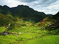
The Banaue Rice Terraces are terraces that were carved into the mountains of Banaue, Ifugao, in the Philippines, by the ancestors of the Igorot people. The terraces are occasionally called the "Eighth Wonder of the World". It is commonly thought that the terraces were built with minimal equipment, largely by hand. The terraces are located approximately 1,500 meters above sea level. These are fed by an ancient irrigation system from the rainforests above the terraces. It is said that if the steps were put end to end, it would encircle half of the globe.

<span class="mw-page-title-main">Banaue</span> Municipality in Ifugao, Philippines

Banaue, officially the Municipality of Banaue is a 4th class municipality in the province of Ifugao, Philippines. According to the 2020 census, it has a population of 20,652 people.

<span class="mw-page-title-main">History of agriculture</span>

Agriculture began independently in different parts of the globe, and included a diverse range of taxa. At least eleven separate regions of the Old and New World were involved as independent centers of origin. The development of agriculture about 12,000 years ago changed the way humans lived. They switched from nomadic hunter-gatherer lifestyles to permanent settlements and farming.

<span class="mw-page-title-main">Rice Terraces of the Philippine Cordilleras</span> World Heritage Site in Luzon, the Philippines

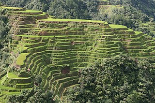
The Rice Terraces of the Philippine Cordilleras are a World Heritage Site consisting of a complex of rice terraces on the island of Luzon in the Philippines. They were inscribed on the UNESCO World Heritage List in 1995, the first-ever property to be included in the cultural landscape category of the World Heritage List. This inscription has five sites: the Batad Rice Terraces and Bangaan Rice Terraces, Mayoyao Rice Terraces, Hungduan Rice Terraces and Nagacadan Rice Terraces, all in Ifugao Province. The Ifugao Rice Terraces reach a higher altitude and were built on steeper slopes than many other terraces. The Ifugao complex of stone or mud walls and the careful carving of the natural contours of hills and mountains combine to make terraced pond fields, coupled with the development of intricate irrigation systems, harvesting water from the forests of the mountain tops, and an elaborate farming system.

<span class="mw-page-title-main">Inca society</span> Pre-Columbian civilization

The Inca society was the society of the Inca civilization in Peru. The Inca Empire, which lasted from 1438 to 1533 A.D., represented the height of this civilization. The Inca state was known as the Kingdom of Cusco before 1438. Over the course of the empire, the rulers used conquest and peaceful assimilation to incorporate a large portion of western South America, centered on the Andes mountain ranges. The empire proved relatively short-lived however: by 1533, Atahualpa, the last Sapa Inca (emperor) of the Inca Empire, was killed on the orders of the conquistador Francisco Pizarro, marking the beginning of Spanish rule. The last Inca stronghold, the Neo-Inca State in Vilcabamba, was conquered by the Spanish in 1572.

<span class="mw-page-title-main">Inca technology</span> Devices, and technologies invented or used in the Inca civilisation

Inca technology includes devices, technologies and construction methods used by the Inca people of western South America, including the methods Inca engineers used to construct the cities and road network of the Inca Empire.

<span class="mw-page-title-main">Andén</span> Agricultural terraces in the Andes

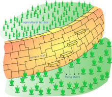
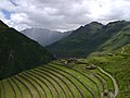
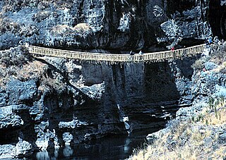
An andén, Spanish for "platform", is a stair-step like terrace dug into the slope of a hillside for agricultural purposes. The term is most often used to refer to the terraces built by pre-Columbian cultures in the Andes mountains of South America. Andenes had several functions, the most important of which was to increase the amount of cultivatable land available to farmers by leveling a planting area for crops. The best known andenes are in Peru, especially in the Sacred Valley near the Inca capital of Cuzco and in the Colca Canyon. Many andenes have survived for more than 500 years and are still in use by farmers throughout the region.

<span class="mw-page-title-main">Incan agriculture</span> Agriculture by the Inca Empire

Incan agriculture was the culmination of thousands of years of farming and herding in the high-elevation Andes mountains of South America, the coastal deserts, and the rainforests of the Amazon basin. These three radically different environments were all part of the Inca Empire and required different technologies for agriculture. Inca agriculture was also characterized by the variety of crops grown, the lack of a market system and money, and the unique mechanisms by which the Incas organized their society. Andean civilization was "pristine"—one of six civilizations worldwide which were indigenous and not derivative from other civilizations. Most Andean crops and domestic animals were likewise pristine—not known to other civilizations. Potatoes and quinoa were among the many unique crops; Camelids and guinea pigs were the unique domesticated animals.

<span class="mw-page-title-main">Ifugao people</span> Ethnic group of the Philippines

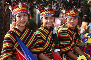
The Ifugao people are the ethnic group inhabiting Ifugao province in the Philippines. They reside in the municipalities of Lagawe, Aguinaldo, Alfonso Lista, Asipulo, Banaue, Hingyon, Hungduan, Kiangan, Lamut, Mayoyao, and Tinoc. The province is one of the smallest provinces in the Philippines with an area of only 251,778 hectares, or about 0.8% of the total Philippine land area. As of 1995, the population of the Ifugaos was counted to be 131,635. Although the majority of them are still in Ifugao province, some of them have moved to Baguio, where they work as woodcarvers, and to other parts of the Cordillera Region.

Indigenous horticulture is practised in various ways across all inhabited continents. Indigenous refers to the native peoples of a given area and horticulture is the practice of small-scale intercropping.

<span class="mw-page-title-main">Natural farming</span> Sustainable farming approach

Natural farming, also referred to as "the Fukuoka Method", "the natural way of farming", or "do-nothing farming", is an ecological farming approach established by Masanobu Fukuoka (1913–2008). Fukuoka, a Japanese farmer and philosopher, introduced the term in his 1975 book The One-Straw Revolution. The title refers not to lack of effort, but to the avoidance of manufactured inputs and equipment. Natural farming is related to fertility farming, organic farming, sustainable agriculture, agroecology, agroforestry, ecoagriculture and permaculture, but should be distinguished from biodynamic agriculture.

The vertical archipelago is a term coined by sociologist and anthropologist John Victor Murra under the influence of economist Karl Polanyi to describe the native Andean agricultural economic model of accessing and distributing resources. While some cultures developed market economies, the predominant models were systems of barter and shared labor. These reached their greatest development under the Inca Empire. Scholars have identified four distinct ecozones, at different elevations.

<span class="mw-page-title-main">Osmore River</span> River in Moquegua Region, Peru

Osmore River system flows northeast to southwest in the Moquegua Region of southern coastal Peru. The river has its origin in the snow peaks of the Chuqi Ananta and Arundane mountains, at an elevation of 5,100 metres (16,700 ft) above sea level. It changes names as it descends from the Andes: From its origin it is called the Moquegua, then Osmore in the middle valley as Rio Coscori and Rio Tumilaca including where the river disappears into subterranean channels, and further down in the lower reaches as Rio Ilo.

<span class="mw-page-title-main">Tiwanaku Empire</span> Pre-Columbian polity in Western Bolivia

The Tiwanaku Polity was a Pre-Columbian polity in western Bolivia based in the southern Lake Titicaca Basin. Tiwanaku was one of the most significant Andean civilizations. Its influence extended into present-day Peru and Chile and lasted from around 600 to 1000 AD. Its capital was the monumental city of Tiwanaku, located at the center of the polity's core area in the southern Lake Titicaca Basin. This area has clear evidence for large-scale agricultural production on raised fields that probably supported the urban population of the capital. Researchers debate whether these fields were administered by a bureaucratic state (top-down) or through a federation of communities with local autonomy. Tiwanaku was once thought to be an expansive military empire, based mostly on comparisons to the later Inca Empire. However, recent research suggests that labelling Tiwanaku as an empire or even a state may be misleading. Tiwanaku is missing a number of features traditionally used to define archaic states and empires: there is no defensive architecture at any Tiwanaku site or changes in weapon technology, there are no princely burials or other evidence of a ruling dynasty or a formal social hierarchy, no evidence of state-maintained roads or outposts, and no markets.

<span class="mw-page-title-main">Jan Nyssen</span> Belgian geographer

Jan Nyssen is a Belgian physical geographer, and professor of geography at Ghent University.

<span class="mw-page-title-main">History of rice cultivation</span>

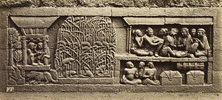
The history of rice cultivation is an interdisciplinary subject that studies archaeological and documentary evidence to explain how rice was first domesticated and cultivated by humans, the spread of cultivation to different regions of the planet, and the technological changes that have impacted cultivation over time.

References

  1. "World Heritage List". UNESCO. Retrieved 2012-09-22.they are Broad flat steps
  2. "On Ancient Terraced Hills, Urbanism Sprouted With Crops". The New York Times. 2 September 1997.
  3. Widgren, Mats (2009). "Mapping precolonial African agricultural systems". p. 5.
  4. Genest, Serge; Muller-Kosack, Gerhard (2003). "The Way of the Beer: Ritual Re-Enactment of History among the Mafa, Terrace Farmers of the Mandara Mountains (North Cameroon)" (PDF). Africa: Journal of the International African Institute. 73 (4): 642–643. doi:10.2307/3556793. ISSN   0001-9720. JSTOR   3556793.
  5. Fred Zaal (1 April 2016). Sustainable Land Management in the Tropics: Explaining the Miracle. Routledge. pp. 145–. ISBN   978-1-317-04776-6.
  6. Gwimbe, Samuel Barde (2014). "Ancient Terraces on Highland Fringes South of the Chad Basin". African Indigenous Knowledge and the Disciplines. Rotterdam: SensePublishers. pp. 45–61. doi:10.1007/978-94-6209-770-4_6. ISBN   978-94-6209-770-4.
  7. Molefi Kete Asante; Ama Mazama (26 November 2008). Encyclopedia of African Religion. SAGE Publications. p. 328. ISBN   978-1-5063-1786-1.
  8. Paudel, G.P., A. McDonald, D.B. Rahut, D.B KC, and S. Justice 2019 Scale-appropriate mechanization impacts on productivity among smallholders: Evidence from rice systems in the mid-hills of Nepal. Land Use Policy 85(2019):104-113.
  9. "Terrace cultivation | agriculture". Encyclopedia Britannica.
  10. "Farming Like the Incas". Smithsonian Magazine. Retrieved 2015-09-20.
  11. An Agricultural Wonder: Japan’s Vanishing Terraced Rice Fields (Photos) (Nippon.com)
  12. Martín, Lidia & González Morales, A & Ojeda, Antonio A.. (2016). Towards a new valuation of cultural terraced landscapes: The heritage of terraces in the Canary Islands (Spain). 26. 499-512. 10.19233/ASHS.2016.31.
  13. Whittington, G. (1967-01-01). "Towards a Terminology for Strip Lynchets". The Agricultural History Review. 15 (2): 103–107. JSTOR   40273237.
  14. 1 2 3 Rubin, Rehav (Buni) (2018). Stories Told by the Mountains: Cultural Landscape Through Time (in Hebrew). Resling. pp. 176–184.
  15. Ron, Zvi (1977). "התפוצה של המדרגות החקלאיות בהרי ירושלים". יהודה ושומרון: פרקים בגיאוגרפיה ישובית, מוקדש לזכרו של אברהם יעקב ברור[Judea and Samaria: studies in settlement geography, in memory of Dr. Avraham Brawer] (in Hebrew). Jerusalem: כנען. pp. 210–229.
  16. U. Davidovich et al., "Archeological Investigations and OSL Dating of Terraces at Ramat Rahel, Israel", Journal of Field Archaeology 37, 3 (2012): 192-208