Census
Demographic data for most of the history of the Ottoman Empire is not quite precise. For most of the five centuries of its existence, the empire did not have easily computable valid data except figures for the number of employed citizens. Until the first official census (1881–1893), data was derived from extending the taxation values to the total population. Because of the use of taxation data to infer population size, detailed data for numerous Ottoman urban centers - towns with more than 5,000 inhabitants - is accurate. This data was collaborated with data on wages and prices. Another source was used for the numbers of landlords of households in the Ottoman Empire- every household was assumed to have 5 residents. [2]
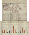
 Town population in the Balkans in the 16th century

1831 Ottoman census
Entire villages remained uncounted. Taxable population was enumerated, i.e. healthy men over 15 years old. For some settlements the rest of the male population was the majority.
| [3] | ||||||
|---|---|---|---|---|---|---|
| Area | Total | Muslim | E. Orthodox | All Roma (Gypsies) | Jews | Armenians |
| Total (Of those counted) | 3,377,307 | 1,316,682 | 1,941,816 | 93,943 | 20,636 | 4,230 |
| Rumeli Eyalet | 337,001 | 686,991 | 25,126 | 9,955 | 2,099 | |
| Çatalca rural | 848 | 2,592 | ||||
| Silivri | 887 | |||||
| Midya | 127 | |||||
| Terkos | 794 | |||||
| Çekmeceıkebır | 464 | |||||
| Çekmeceısagır | 403 | |||||
| Tiirkeşçıttiığı | 29 | |||||
| Tekturdağı | 3,773 | 7,727 | 57 | |||
| Inecik | 812 | 836 | 24 | |||
| Malkara | 1,511 | 4,010 | 64 | |||
| Gelibolu | 4,179 | 6,613 | ||||
| Şarköy | 962 | 7,752 | ||||
| Bergos | 1,860 | 3,154 | 32 | 51 | ||
| Çorlu | 971 | 1,938 | 45 | 73 | ||
| Marmara Ereğlisi | 177 | 554 | 24 | |||
| Babayiatik | 542 | 1,253 | ||||
| Havas Mahmutpaşa | 684 | 896 | ||||
| Hayrabolu | 2,203 | 1,051 | ||||
| Evreşe | 666 | 956 | 39 | |||
| Inoz | 274 | 2,327 | 62 | |||
| Keşan | 850 | 4,557 | 72 | |||
| Çisriergene | 1,929 | 8,886 | ||||
| Ipsala | 955 | 1,512 | ||||
| Edirne | 18,487 | 16,789 | 750 | 1,541 | 1,443 | |
| Ada rural | 1,090 | 5,214 | ||||
| Çdke rural | 1,990 | 4,803 | ||||
| Üsküdar and Manastır rural | 2,333 | 17,040 | ||||
| Tırfelli rural | 181 | |||||
| Çisri Muştafa Paşa | 914 | 1,329 | ||||
| Çirmen | 1,910 | 1,262 | ||||
| Çirpan | 938 | 4,619 | ||||
| Ahlçelebi | 6,080 | 4,107 | ||||
| Akçakizanllk | 7,195 | 8,097 | 748 | |||
| Zağraiatık | 5,586 | 12,782 | ||||
| Dimetoka | 7,525 | 10,852 | ||||
| Ferecık | 2,385 | 3,473 | ||||
| Meğri | 692 | 833 | ||||
| Gumülcine | 30,517 | 5,339 | 1,712 | |||
| Yenıceikerasu | 7,582 | 2,540 | 1,273 | |||
| Uzuncaabat Hasköy | 9,941 | 10,118 | 633 | |||
| Sultanyeri | 6,251 | 51 | 89 | |||
| Drama | 8,618 | 3,077 | 1,007 | |||
| Cığlacik and San Şaban | 4,986 | 131 | 54 | |||
| Tırnova | 3,051 | |||||
| Hutaliç rural | 7,543 | |||||
| Torluk rural | 5,108 | |||||
| Sahra rural | 2,678 | |||||
| Filibe | 10,920 | 44,959 | 2,021 | 344 | 344 | |
| Pazarcik | 3,269 | 14,083 | 3,653 | 119 | ||
| Ihtaman | 408 | 1,501 | 83 | |||
| Sofya | 4,161 | 39,692 | 886 | |||
| Şehirköy | 1,341 | 27,643 | 379 | |||
| Pravişte | 4,718 | 2,596 | 259 | |||
| Bereketlu | 967 | 170 | ||||
| Kavala | 1,514 | 102 | ||||
| Berkofca | 1,125 | 13,549 | 382 | |||
| Cuma Pazari | 3,733 | 916 | ||||
| Egri Bucak | 1,482 | 1,294 | ||||
| Çarşamba | 2,350 | 1,717 | ||||
| Serfıce | 682 | 2,260 | ||||
| Tikveş | 4,454 | 6,104 | ||||
| Petriç | 3,893 | 3,869 | ||||
| Radovişte | 3,504 | 4,907 | ||||
| Nevrekop | 8,539 | 8,620 | 739 | |||
| Melnik | 918 | 4,182 | 260 | |||
| Timurhisar | 3,229 | 6,611 | 494 | |||
| Zihne | 2,867 | 10,017 | 642 | |||
| Siroz | 4,459 | 16,596 | 1,761 | 248 | ||
| Selanik | 12,368 | 2,1669 | 511 | 5,667 | ||
| Yenice Vardar | 6,811 | 4,766 | ||||
| Vodine | 3,996 | 3,883 | ||||
| Karaferiye | 1,680 | 11,052 | ||||
| Ağustos | 151 | 737 | ||||
| Perzinek | 215 | 4,436 | ||||
| Iznebol | 131 | 5,152 | 151 | |||
| Ustrumca | 3,674 | 5,344 | 546 | |||
| Toyran | 4,631 | 3,076 | 334 | |||
| Karadağ | 2,722 | 1,452 | 108 | |||
| Avrathisar | 3,176 | 6,949 | 332 | |||
| Dupniçe | 3,528 | 11,642 | ||||
| Radomir | 789 | 7,211 | ||||
| Ivraca | 1,463 | 14,282 | 262 | |||
| Kratova, Ivraniye, Palangai, Eğridere | 4,749 | 21,068 | 627 | |||
| Vidin, Akçar, Karalom, Belgratçik, Çunarka, Godgoskaca and Esterlik rural | 6,695 | 24,846 | 1,289 | |||
| Köprülü | 4,767 | 12,718 | 390 | |||
| Perlepe | 3,683 | 14,489 | 450 | |||
| Samokov | 816 | 11,973 | 11 | 94 | ||
| Köstendil | 3,032 | 14,070 | 232 | 145 | ||
| Behişte | 3,202 | 2,176 | 89 | |||
| Kesriye | 3,313 | 16,124 | 335 | |||
| Persepe | 568 | 2,162 | ||||
| Manastir | 6,723 | 24,550 | 705 | 1,163 | ||
| Florina | 5,596 | 5,253 | 365 | |||
| Istrova | 1,658 | 1,176 | 57 | |||
| Hotpeşte | 2,081 | 3,630 | 43 | |||
| Nasliç | 2,693 | 5,748 | 275 | |||
| Iştip | 6,920 | 9,826 | ||||
| Koçana | 3,374 | 6,112 | ||||
| Kumanova | 2,276 | 10,819 | ||||
| Silistre Eyalet | 150,970 | 96,342 | 8,779 | 178 | ||
| Niğbolu Sancak | 110,304 | 81,489 | 5,804 | 178 | ||
| Selvı | 7,734 | |||||
| Izladi | 2,580 | |||||
| Etripolu | 545 | |||||
| Lofça | 12,404 | |||||
| Plevne | 6,031 | |||||
| Rahova | 1,831 | |||||
| Sipre | 235 | |||||
| Niğbolu | 3,893 | 8,598 | 1,190 | |||
| Ziştovi | 3,897 | 5,760 | 629 | |||
| Rusçuk | 1,6165 | 7,196 | 1,437 | |||
| Yanbolu | 1,942 | 1,507 | ||||
| Nevahii Yanbolu | 1,444 | 1,237 | ||||
| Zağraicedıt | 3,292 | 4,745 | ||||
| Yenicei Kızılağaç, Hatunili | 499 | 1,502 | ||||
| Niš | 1,862 | 18,378 | 575 | 178 | ||
| Prizren | 9,488 | 2,867 | 366 | |||
| Yehud | 2,768 | 2,479 | 44 | |||
| Tırguvişte | 2,404 | 2,323 | 3 | |||
| Gude | 7,574 | 100 | ||||
| Usküp | 9,660 | 11,700 | 900 | |||
| Kalkandelen | 11,766 | 8,043 | 472 | |||
| Kirçova | 2,286 | 5,154 | 88 | |||
| Silistre Sancak | 40,666 | 14,853 | 2975 | |||
| Varna | 3,427 | 1,573 | 167 | |||
| Isakçi | 553 | 605 | 39 | |||
| Minkalye | 694 | 15 | 37 | |||
| Balçik and Kuvarna | 1766 | 630 | 125 | |||
| Karkkala rural | 52 | |||||
| Maçin | 991 | 821 | 25 | |||
| Köstence | 1,417 | 386 | 41 | |||
| Hırsova | 1,391 | 986 | 21 | |||
| Tulça | 472 | 592 | 19 | |||
| Kannabad | 5,065 | 1,454 | 358 | |||
| Babadağ | 1,171 | 1,661 | 38 | |||
| Doskasri | 1,114 | 596 | 273 | |||
| Aydos | 5,790 | 845 | 449 | |||
| Yenipazar | 3482 | 948 | 300 | |||
| Pravadı | 4,530 | 1,465 | 231 | |||
| Umurfakih | 1,140 | 146 | ||||
| Kozluca | 1,840 | 1,163 | 146 | |||
| Pazarcık | 3,515 | 761 | 287 | |||
| Çardak | 2,308 | 300 | 223 | |||
| Republic of Bulgaria borders [4] | 181,455 | 296,769 | 1,7474 | 702 | 344 | |
1844 Ottoman census
| District | Muslims [5] |
|---|---|
| Rumelia | 29% |
1881–1893 Ottoman census
The first official census (1881–1893) took 10 years to finish. In 1893 the results were compiled and presented. This census is the first modern, general and standardized census accomplished not for taxation nor for military purposes, but to acquire demographic data. The population was divided into ethno-religious and gender characteristics. Numbers of both male and female subjects are given in ethno-religious categories including Muslims, Greeks (including Asia Minor Greeks, Pontic Greeks, and Caucasus Greeks, all Orthodox Christians under the Greek Orthodox Patriarchate of Constantinople from extremely distinct ethnic origin), Armenians, Bulgarians, Catholics, Jews, Protestants, Latins, Syriacs and Roma. [6] [7]
In 1867 the Council of States took charge of drawing population tables, increasing the precision of population records. They introduced new measures of recording population counts in 1874. This led to the establishment of a General Population Administration, attached to the Ministry of Interior in 1881–1882. These changes politicized the population counts.
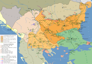
- Population maps 1893-96
 1893-96, Muslim, Greek and Armenian population
 1893-96, Armenian distribution (in color)
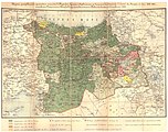 1893-96, Green shows Muslim majority, red shows Armenian majority.


| Ottoman Census Values | |||
|---|---|---|---|
| Administrative Unit | Total Pop | Armenian Pop | Armenian % |
| Van Vilayet | 132,007 | 55,051 | 41.70% |
| Bitlis Vilayet | 338,642 | 108,050 | 31.91% |
| Izmit | 228,443 | 44,953 | 19.68% |
| Erzurum Vilayet | 637,015 | 120,147 | 18.86% |
| Dersaadet | 903,482 | 166,185 | 18.39% |
| Vilayet of Mamuret-ul-Aziz | 466,579 | 83,394 | 17.87% |
| Diyarbekir Vilayet | 414,657 | 60,175 | 14.51% |
| Sivas Vilayet | 980,876 | 129,085 | 13.16% |
| Adana Vilayet | 398,764 | 36,695 | 9.20% |
| Halep Vilayet | 819,238 | 70,663 | 8.63% |
| Ankara Vilayet | 1,018,744 | 81,437 | 7.99% |
| Hüdavendigar Vilayet | 1,454,294 | 70,262 | 4.83% |
| Trabzon Vilayet | 1,164,595 | 49,782 | 4.27% |
| Sehremanati Mülhakati | 88,306 | 3,074 | 3.48% |
| Edirne | 985,962 | 18,458 | 1.87% |
| Çatalca | 61,001 | 979 | 1.60% |
| Biga | 143,904 | 1,842 | 1.28% |
| Konya | 1,022,834 | 10,972 | 1.07% |
| Aydin | 1,478,424 | 15,229 | 1.03% |
| Zor | 51,270 | 474 | 0.92% |
| Kastamonu | 968,884 | 6,652 | 0.69% |
| Kudüs | 258,860 | 1,610 | 0.62% |
| Beyrut | 620,763 | 2,921 | 0.47% |
| Suriye | 551,135 | 1,478 | 0.27% |
| Selanik | 1,038,953 | 51 | 0.00% |
| Cezayir-i Bahri Sefid | 286,736 | 10 | 0.00% |
| Manastir | 711,466 | 22 | 0.00% |
| 1,139,651 | |||
1905–1906 Ottoman census
- Population maps 1905-1906, 1914
 1905-1906 (printed in 1911)
 Muslim population in the Ottoman vilayets (1907)
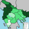 Muslim population in the Ottoman sanjaks


After 1893 the Ottoman Empire established a statistics authority (Istatistik-i Umumi Idaresi) under which results of another official census was published in 1899.
Istatistik-i Umumi Idaresi conducted a new census survey for which field work lasted two years (1905–06). 2-3 million people in Iraq and Syria remained unregistered and uncounted. [8] As a factual note this survey's complete (total) documentation was not published. Results of regional studies on this data were published later, which were sorted by their publication date. Included in the publication and subsequent ones was the Ottoman Empire's population as of 1911, 1912, and 1914. The substantial archival documentation on the census has been used in many modern studies and international publications. After 1906 the Ottoman Empire began to disband and a chain of violent wars such as the Italo-Turkish War, Balkan Wars and World War I drastically changed the region, its borders, and its demographics.
| Population distribution of the Millets in the Ottoman Empire in 1906, according to the official census [9] - [10] | |||||||||
| Millet | Inhabitants | % of total | |||||||
|---|---|---|---|---|---|---|---|---|---|
| Muslims a | 15,498,747 - 15,518,478 | 76.09% - 74.23% | |||||||
| Greeks b | 2,823,065 - 2,833,370 | 13.86% - 13.56% | |||||||
| Armenians c | 1,031,708 - 1,140,563 | 5.07% - 5.46% | |||||||
| Bulgarians | 761,530 - 762,754 | 3.74% - 3.65% | |||||||
| Jews | 253,435 - 256,003 | 1.24% - 1.23% | |||||||
| Protestants d | 53,880 | 0.26% | |||||||
| Othersd | 332,569 | 1.59% | |||||||
| Total | 20,368,485 - 20,897,617 | 100.00% | |||||||
| Notes:aThe Muslim Millet includes all Muslims. The largest of them being Turks, Arabs and Kurds. bThe Greek Millet includes all Christians part of the Greek Orthodox Church. This includes Slavs and Albanians. cThis includes the various Assyrian Churches. dThe first source doesn't include Protestants and "others". | |||||||||
1914 Ottoman census
 1914, Muslim, Greek and Armenian population

| 1914 Official Census Values (Male-Female Aggregated) [11] | |||
|---|---|---|---|
| Province | Muslim | Armenian | Greek |
| Adana | 341.903 (74.8%) | 52.650 (13%) | 8.974 (2.2%) |
| Ankara | 877.285 (92.5%) | 51.556 (5.4%) | 20.240 (2.1%) |
| Antalya | 235.762 (95.01%) | 630 (.02%) | 12.385 (4.97%) |
| Aydın (İzmir) | 1.249.067 | 20.287 | 299.097 |
| Bitlis | 309.999 (72.5%) | 117.492 (27.5%) | 0 |
| Bolu | 399.281 | 2.970 | 5.115 |
| Canik | 265.950 | 27.319 | 98.739 |
| Çatalca | 20.048 | 842 | 36.791 (63.78%) |
| Diyarbekir | 492.101 | 65.850 | 1.935 |
| Edirne | 360.411 | 19.773 | 224.680 |
| Erzurum | 673.297 | 134.377 | 4.864 |
| Eskişehir | 140.678 | 8.592 | 2.613 |
| Halep | 576.320 | 40.843 | 21.954 |
| Harput | 446.379 | 79.821 | 971 |
| Hüdavendigâr | 474.114 | 60.119 | 74.927 |
| İçil | 102.034 | 341 | 2.507 |
| İzmit | 226.859 | 55.852 | 40.048 |
| Kale-i Sultaniye | 149.903 | 2.474 | 8.550 |
| Kastamonu | 737.302 | 8.959 | 20.958 |
| Karahisar-ı Sahib | 277.659 | 7.439 | 632 |
| Karesi | 359.804 | 8.653 | 97.497 |
| Kayseri | 184.292 | 50.174 | 26.590 |
| Konya | 750.712 | 12.971 | 25.150 |
| Kostantiniyye | 560.434 | 82.880 | 205.752 |
| Menteşe | 188.916 | 12 | 19.923 |
| Kütahya | 303.348 | 4.548 | 8.755 |
| Maraş | 152.645 | 32.322 | 34 |
| Niğde | 227.100 | 4.936 | 58.312 |
| Sivas | 939.735 | 147.099 | 75.324 |
| Trabzon | 921.128 | 38.899 | 161.574 |
| Urfa | 149.384 | 16.718 | 2 |
| Van | 179.380 | 67.792 | 1 |
| Zor | 65.770 | 232 | 45 |
| Total | 13.390.000 (83,02%) | 1.173.422 (7,28%) | 1.564.939 (9,70%) |
| Total | 16.128.361 | ||
1866 Danube Vilayet census
In 1865, 658600 (40,51%) Muslims and 967058 (59,49%) non-Muslims, including females, were living in the province excluding Niş sanjak and 569.868 (34,68%) Muslims, apart from the immigrants and 1.073.496 (65,32%) non-Muslims in 1859–1860. [12] Half the Muslims were refugees from a population exchange of Christians and Muslims with Russia. Before the establishment of the Danube Vilayet, some 250000-300000 Muslim immigrants from Crimea and Caucasus had been settled in this region from 1855 to 1864. Another 200–300,000 male and female Circassian and Crimean Tatar refugees settled in 1862-1878 were to a degree excluded from the 1866 census count. [5]
Male population of the taxable population of the, Danube Vilayet:
| 1866 census [5] | ||
|---|---|---|
| sancak | Muslim | Non-Muslim |
| Rusçuk | 138692 | 95834 |
| Varna | 58689 | 20769 |
| Vidin | 25338 | 124567 |
| Sofya | 24410 | 147095 |
| Tirnova | 71645 | 104273 |
| Tulça | 39133 | 17929 |
| Niş | 54510 | 100425 |
| Total | 412417 | 610892 |
Percentage of communities in towns from the male population in 1866 according to Ottoman teskere: [13]
| Town | Bulgarians | Muslims | Roma | Armenians | Jews |
|---|---|---|---|---|---|
| Vidin | 34 | 52 | 6 | 8 | |
| Sofya | 38 | 39 | 4 | 20 | |
| Lom | 58 | 35 | 3 | 5 | |
| Dupnice | 38 | 46 | 5 | 11 | |
| Plevne | 47 | 45 | 5 | 2 | |
| Rusçuk | 38 | 52 | 2 | 4 | 5 |
| Şumnu | 40 | 51 | 1 | 5 | 2 |
| Varna | 49 | 40 | 1 | 8 | 2 |
| Silistre | 30 | 62 | 2 | 4 | 1 |
In 1873, 17,96% of the population of the province were living in the urban areas.
1874 Danube Vilayet census
According to the 1874 census, there were 963596 (42,22%) Muslims and 1318506 (57,78%) non-Muslims in the Danube Province excluding Nış sanjak. Together with the sanjak of Nish the population consisted of 1055650 (40,68%) Muslims and 1539278 (59,32%) non-Muslims in 1874. Muslims were the majority in the sanjaks of Rusçuk, Varna and Tulça, while the non-Muslims were in majority in the rest of the sanjaks. [14]
Eastern Rumelia census
Census in Eastern Rumelia of 1878: [15]
| Community (1878 census) | Population | Percentage |
|---|---|---|
| Bulgarians | 571231 | 70.3% |
| Muslims | 174759 | 21.4% |
| Greeks | 42516 | 5.2% |
| Roma (Gypsies) | 19524 | |
| Jews | 4177 | |
| Armenians | 1306 |
Census of Eastern Rumelia in 1880: [16]
| Ethnicity (1880 census) | Population | Percentage |
|---|---|---|
| Bulgarians | 590000 | 72.3% |
| Turks | 158000 | 19.4% |
| Roma (Gypsies) | 19500 | 2.4% |
| others | 48000 | 5.9% |
The ethnic composition of the population of Eastern Rumelia, according to the provincial census taken in 1884, was the following: [17]
| Ethnicity (1884 census) | Population | Percentage |
|---|---|---|
| Bulgarians | 681,734 | 70.0% |
| Turks | 200,489 | 20.6% |
| Greeks | 53,028 | 5.4% |
| Roma (Gypsies) | 27,190 | 2.8% |
| Jews | 6,982 | 0.7% |
| Armenians | 1,865 | 0.2% |
Population of Eastern Rumelia according to the 1880 census: [18]
| kaza | Bulgarians | Turks | Greeks | Roma | Jews | Armenians |
|---|---|---|---|---|---|---|
| Plovdiv | 127.619 | 36.848 | 14.265 | 4736 | 1185 | 806 |
| Haskovo | 74.656 | 55.334 | 1138 | 2116 | 246 | |
| Stara Zagora | 124.666 | 27.115 | 35 | 2811 | 431 | |
| Sliven | 96.425 | 12.463 | 14.184 | 3685 | 845 | 276 |
| Pazardzhik | 94.873 | 14.898 | 676 | 3487 | 1112 | 152 |
| Burgas | 36.997 | 28.091 | 11.798 | 2686 | 358 | 71 |
1903–1904 census of Salonika Vilayet
Population of the Salonika vilayet: [13]
| sanjak | Muslims | Greeks | Bulgarians | Vlachs [lower-alpha 1] | Jews |
|---|---|---|---|---|---|
| Saloniki | 220.000 | 190.000 | 85.000 | 15.000 | 48.000 |
| Serres | 145.000 | 78.000 | 130.000 | 4000 | 2000 |
| Drama | 119.000 | 22.000 | 4000 | 1000 |