Dempster Highway

Last updated

Yukon Highway 5.svg NWT-8.svg

Dempster Highway

Yukon Highway 5
Northwest Territories Highway 8
Highway 5 map-YT.png
Route information
Maintained by Department of Highways and Public Works
Length737.5 km (458.3 mi)
YT-5: 465 km (289 mi)
NWT-8: 271 km (168 mi)
Major junctions
South endYukon Highway 2.svg Hwy 2 (Klondike Highway) near Dawson City, YT
North endNWT-10.svg Highway 10 (Inuvik–Tuktoyaktuk Highway), Inuvik, NT
Location
Country Canada
Province Yukon
Highway system
    Yukon Highway 4.svg Hwy 4 Yukon Highway 5.svg Yukon Highway 6.svg Hwy 6
    NWT-7.svg Highway 7 NWT-8.svg NWT-9.svg Highway 9

    The Dempster Highway, also referred to as Yukon Highway 5 and Northwest Territories Highway 8, is a highway in Canada that connects the Klondike Highway in Yukon to Inuvik, Northwest Territories on the Mackenzie River delta. The highway crosses the Peel and the Mackenzie rivers using a combination of seasonal ferry services and ice bridges. Year-round road access from Inuvik to Tuktoyaktuk opened in November 2017, with the completion of the Inuvik–Tuktoyaktuk Highway, [1] creating the first all-weather road route connecting the Canadian road network with the Arctic Ocean.

    Contents

    The highway is named for North-West Mounted Police (NWMP) officer William Dempster, who earned renown for discovering the fate of a lost NWMP patrol in 1911.

    Route description

    The highway begins 40 km (25 mi) east of Dawson City, Yukon on the Klondike Highway. There are no highway or major road intersections along the highway's route. It extends 736 km (457 mi) in a north-northeasterly direction to Inuvik, Northwest Territories, passing through Tombstone Territorial Park and crossing the Ogilvie and Richardson mountain ranges.

    History

    Dempster Highway near the Richardson Mountains Dempsterhighway.jpg
    Dempster Highway near the Richardson Mountains

    The Dempster Highway roughly follows the old dog sled route from Dawson City to Fort McPherson and is named for Corporal (later Inspector) William Dempster of the North-West Mounted Police. [2]

    During the late 19th century, and in response to the Klondike Gold Rush, the North-West Mounted Police established a presence in the Yukon and Northwest Territories. Their activities included winter dog sled patrols between outposts and communities. One such patrol followed a route from Dawson City to the NWMP outpost at Fort McPherson, established in 1903.

    In December 1910, NWMP Inspector Francis Joseph Fitzgerald led three men on the annual winter patrol from Fort McPherson to Dawson City. They became lost on the trail, and subsequently died of exposure and starvation. When they failed to arrive in Dawson City as expected, Corporal Dempster and two constables were sent out on a rescue patrol in March 1911. Dempster and his men found the bodies of Fitzgerald's patrol on March 22, 1911. [3]

    Construction

    Expedition by Cpl. William Dempster in search of the Lost Patrol, Dawson City, Yukon Territory, 1911. Dempster Expedition 1911.jpg
    Expedition by Cpl. William Dempster in search of the Lost Patrol, Dawson City, Yukon Territory, 1911.

    In 1958, as oil and gas exploration were expanding in the Mackenzie Delta, the Canadian government decided to build a road from Dawson City in Yukon to Aklavik in the Northwest Territories. The road was intended as an overland, year-round supply link to southern Canada. [4] Survey work began in 1958. [5]

    With the August, 1959, discovery of oil in the Eagle Plains area, the government granted concessions to the oil industry to stimulate more exploration in the area. This provided more motivation for a road to transport equipment, infrastructure, and revenue to and from the sites. [4] Construction of the road, then known as Yukon Territorial Road No. 11, began at Dawson City in January 1959. [6] The northern terminus of the road was changed to the new town of Inuvik. Due to high costs and ongoing funding disagreements between the federal and Yukon governments, progress was slow until 1961. Once the Eagle Plains oil discovery was found to have no commercial potential, construction stopped in 1962 after 115 km (71 mi) of roadbed had been built. [4]

    Seasonal maintenance of the existing road continued but no further work was done. In 1964, the road was renamed the Dempster Highway, after petitions by Vancouver Yukoners Association and the Yukon Order of Pioneers. [5] Construction resumed in 1970 as the Canadian government sought to assert sovereignty over their Arctic territories after the American discovery of oil and gas deposits at Prudhoe Bay, Alaska in 1968. Work was further motivated by speculation that an oil pipeline might be built in the Mackenzie Valley.

    At the time of its construction, the highway was the most northerly major road project to date. Weather and daylight conditions presented challenges. In 1979, a work crew was trapped in a blizzard in the Richardson Mountains and was almost lost. [5] Construction had to account for the permafrost; heat transfer from the highway to the ground had to be prevented so the permafrost would not melt. To address this, the road was built on top of a gravel berm, ranging from 1.2 to 2.4 m (3 ft 11 in to 7 ft 10 in), to insulate the permafrost from the road above. [4] Some construction was completed by the Canadian Forces; 3 Field Squadron, RCE from CFB Chilliwack built bridges over the Ogilvie River in 1971 [7] and the Eagle River in 1977. [8]

    The final section of road was completed in 1978, at a cost of $132 million. [5] The highway was officially opened on August 18, 1979, at Flat Creek, Yukon. [6]

    Major intersections

    Territory Region Locationkm [9] miDestinationsNotes
    Yukon unorganized 00.0Yukon Highway 2.svg Hwy 2 (Klondike Highway) Dawson City, Whitehorse
    8251 North Fork Pass – 1,289 m (4,229 ft)Highest point on the Dempster Highway
    Eagle Plains 369229First available services
    391243Ontario M502.svg Wiley Aerodrome Uses a portion of the highway as its runway.
    405252 Arctic Circle
    Yukon – Northwest Territories border465289Yukon Highway 5.svg Hwy 5 northern terminus • NWT-8.svg Highway 8 southern terminus
    One hour time change (summer only)
    Northwest Territories Inuvik 539335Crosses the Peel River
    Ontario M508.svg MV Abraham Francis (June to October) • Ice bridge (late November to April) [10]
    Fort McPherson 550340Second and last available services
    Tsiigehtchic 608378Crosses the Mackenzie River
    Ontario M508.svg MV Louis Cardinal (June to October) • Ice bridge (late November to April) [10]
    Inuvik 736457NWT-10.svg Highway 10 north (Inuvik–Tuktoyaktuk Highway) Tuktoyaktuk
    1.000 mi = 1.609 km; 1.000 km = 0.621 mi
    •        Route transition

    See also

    Related Research Articles

    <span class="mw-page-title-main">Northwest Territories</span> Territory of Canada

    The Northwest Territories is a federal territory of Canada. At a land area of approximately 1,144,000 km2 (442,000 sq mi) and a 2016 census population of 41,790, it is the second-largest and the most populous of the three territories in Northern Canada. Its estimated population as of 2022 is 45,605. Yellowknife is the capital, most populous community, and only city in the territory; its population was 19,569 as of the 2016 census. It became the territorial capital in 1967, following recommendations by the Carrothers Commission.

    <span class="mw-page-title-main">Yukon</span> Territory of Canada

    Yukon is the smallest and westernmost of Canada's three territories. It also is the second-least populated province or territory in Canada, with a population of 43,964 as of March 2022. Whitehorse, the territorial capital, is the largest settlement in any of the three territories.

    <span class="mw-page-title-main">Inuvik</span> Arctic town in the Northwest Territories, Canada

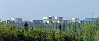
    Inuvik is the only town in the Inuvik Region, and the third largest community in Canada's Northwest Territories. Located in what is sometimes called the Beaufort Delta Region, it serves as its administrative and service centre and is home to federal, territorial, and Indigenous government offices, along with the regional hospital and airport.

    <span class="mw-page-title-main">Mackenzie River</span> Largest river system in Canada

    The Mackenzie River is a river in the Canadian boreal forest. It forms, along with the Slave, Peace, and Finlay, the longest river system in Canada, and includes the second largest drainage basin of any North American river after the Mississippi.

    <span class="mw-page-title-main">Numbered highways in Canada</span> Highways of Canada by province and territory

    Numbered highways in Canada are split by province, and a majority are maintained by their province or territory transportation department. All highways in Canada are numbered except for three in the Northwest Territories, one in Alberta, one in Ontario, and one in Quebec. Ontario's 7000 series are not marked with their highway number but have been assigned one by the Ministry of Transportation. A number of highways in all provinces are better known locally by their name rather than their number. Some highways have additional letters added to their number: A is typically an alternate route, B is typically a business route, and other letters are used for bypass (truck) routes, connector routes, scenic routes, and spur routes. The territory of Nunavut has no highways.

    <span class="mw-page-title-main">Dawson City</span> Town in Yukon, Canada

    Dawson City, officially the City of Dawson, is a town in the Canadian territory of Yukon. It is inseparably linked to the Klondike Gold Rush (1896–99). Its population was 1,577 as of the 2021 census, making it the second-largest town in Yukon.

    <span class="mw-page-title-main">Tuktoyaktuk</span> Hamlet in the Northwest Territories, Canada

    Tuktoyaktuk, or TuktuyaaqtuuqIPA: [təktujaːqtuːq], is an Inuvialuit hamlet located in the Inuvik Region of the Northwest Territories, Canada, at the northern terminus of the Inuvik–Tuktoyaktuk Highway. Tuktoyaktuk, one of six Inuvialuit communities in the Inuvialuit Settlement Region, is commonly referred to simply by its first syllable, Tuk. The settlement lies north of the Arctic Circle on the shores of the Arctic Ocean, and is the only community in Canada on the Arctic Ocean that is connected to the rest of Canada by road. Formerly known as Port Brabant, the community was renamed in 1950 and was the first place in Canada to revert to the traditional Indigenous name.

    The Roads to Resources Program was initiated by the Progressive Conservative government of Prime Minister of Canada John Diefenbaker from 1957 to 1963.

    <span class="mw-page-title-main">Geography of Yukon</span>

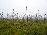
    Yukon is in the northwestern corner of Canada and is bordered by Alaska and the Northwest Territories. The sparsely populated territory abounds with natural scenic beauty, with snowmelt lakes and perennial white-capped mountains, including many of Canada's highest mountains. The territory's climate is Arctic in territory north of Old Crow, subarctic in the region, between Whitehorse and Old Crow, and humid continental climate south of Whitehorse and in areas close to the British Columbia border. Most of the territory is boreal forest with tundra being the main vegetation zone only in the extreme north and at high elevations.

    <span class="mw-page-title-main">Peel River (Canada)</span> River in Northwest Territories, Canada

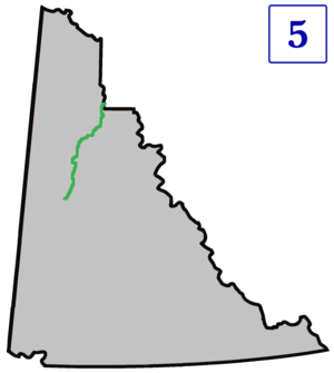
    The Peel River is a tributary of the Mackenzie River in the Yukon and Northwest Territories in Canada. Its source is in the Ogilvie Mountains in the central Yukon at the confluence of the Ogilvie River and Blackstone River. Its main tributaries are:

    <span class="mw-page-title-main">Fort McPherson, Northwest Territories</span> Hamlet in Northwest Territories, Canada

    Fort McPherson is a hamlet located in the Inuvik Region of the Northwest Territories, Canada. It is located on the east bank of the Peel River and is 121 km (75 mi) south of Inuvik on the Dempster Highway.

    <span class="mw-page-title-main">History of Yukon</span> Aspect of history

    The history of Yukon covers the period from the arrival of Paleo-Indians through the Beringia land bridge approximately 20,000 years ago. In the 18th century, Russian explorers began to trade with the First Nations people along the Alaskan coast, and later established trade networks extending into Yukon. By the 19th century, traders from the Hudson's Bay Company were also active in the region. The region was administered as a part of the North-Western Territory until 1870, when the United Kingdom transferred the territory to Canada and it became the North-West Territories.

    <span class="mw-page-title-main">Tuktoyaktuk Winter Road</span> Former ice road in the Northwest Territories, Canada

    Tuktoyaktuk Winter Road, an extension of the Dempster Highway, was an ice road on frozen Mackenzie River delta channels and the frozen Arctic Ocean between the Northwest Territories communities of Inuvik and Tuktoyaktuk, in Canada. The road closed permanently on 29 April 2017 at the end of the 2016-2017 winter season. Construction of an all-season highway between Inuvik and Tuktoyaktuk commenced in April 2013; it opened on 15 November 2017.

    <span class="mw-page-title-main">Inuvialuit Settlement Region</span> Region in Canada

    The Inuvialuit Settlement Region, abbreviated as ISR, located in Canada's western Arctic, was designated in 1984 in the Inuvialuit Final Agreement by the Government of Canada for the Inuvialuit people. It spans 90,650 km2 (35,000 sq mi) of land, mostly above the tree line, and includes several subregions: the Beaufort Sea, the Mackenzie River delta, the northern portion of Yukon, and the northwest portion of the Northwest Territories. The ISR includes both Crown Lands and Inuvialuit Private Lands.

    <i>Ice Road Truckers</i> (season 2) Season of television series

    This is a list of Ice Road Truckers Season 2 episodes.

    At the top of the world, there's an outpost like no other…and a job only a few would dare. The ice men return: two titans of the southern ice roads, and two contenders. Last season they drove loaded semis on frozen lakes…this year, the Arctic Ocean. Deeper into the deep freeze. Further out on thinner ice. The new mission: to haul the heavy metal of natural gas drilling rigs up a frozen river and across ice-choked seas. Ice road truckers have come to the edge of the earth. These are the men who make their living on thin ice.

    Walter Muma is a Canadian man who is on record for completing a 3-month 11,500-mile (18,660 km) journey across Canada and Alaska by moped. The journey took place during the summer of 1978, began in Toronto, passed through Yukon and Alaska, continued up the Dempster Highway to Inuvik, Northwest Territories, and finally back to Toronto.

    <span class="mw-page-title-main">Francis Joseph Fitzgerald</span>

    Francis Joseph Fitzgerald was a Canadian who became a celebrated Boer War veteran and the first commander of the Royal North-West Mounted Police detachment at Herschel Island in the Western Arctic (1903). From December 1910 until February 1911, he led a mail patrol from Fort McPherson southward to Dawson City. When the patrol did not arrive in time, a search party, led by Corporal William Dempster, was sent from Dawson City and found the bodies of Fitzgerald and the other patrol members. The trip became known as "The Lost Patrol" and as "one of Yukon’s greatest tragedies."

    <span class="mw-page-title-main">North-West Mounted Police in the Canadian north</span>

    The history of the North-West Mounted Police in the Canadian north describes the activities of the North-West Mounted Police in the North-West Territories at the end of the 19th century and the start of the 20th. The mounted police had been established to control the prairies along the Canadian-United States border in 1873, but were then also deployed to control the Yukon region during the Klondike Gold Rush, and subsequently expanded their operations into the Hudson Bay area and the far north. The force was amalgamated in 1920 to form part of the new Royal Canadian Mounted Police, who continued their predecessors' work across the region.

    <span class="mw-page-title-main">Inuvik–Tuktoyaktuk Highway</span> Highway in the Northwest Territories, Canada

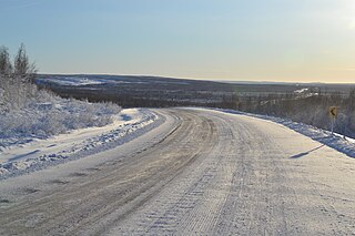
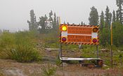
    The Inuvik–Tuktoyaktuk Highway (ITH), officially Northwest Territories Highway 10, is an all-weather road between Inuvik and Tuktoyaktuk in the Northwest Territories, Canada. It is the first all-weather road to Canada's Arctic Coast. The idea for the highway had been considered for decades; however, final approval was not until 2013, with construction beginning in 2014. It was officially opened on November 15, 2017, opening up Tuktoyaktuk to year-round vehicle traffic, which is hoped to increase tourism in the area.

    <span class="mw-page-title-main">William Dempster</span> North-West Mounted Police officer in the Yukon Territory (1876–1964)

    William John Duncan Dempster was a member of the North-West Mounted Police (NWMP) in the Yukon Territory during the early 20th century. He gained notice for his involvement in finding the Lost Patrol, three NWMP officers and an ex-NWMP officer/guide who disappeared on the trail between Fort McPherson and Dawson City in the winter of 1910–11. The Dempster Highway in northern Canada is named for him.

    References

    1. "GCR - News - First ever road to Canada's Arctic coast to open this week". www.globalconstructionreview.com. Retrieved 2017-11-23.
    2. Morrison, William R. (January 1986). "W.J.D. Dempster". Arctic. 39 (2): 190–191. Archived from the original on 6 October 2015. Retrieved 24 November 2017.
    3. North, Dick (2004). The Lost Patrol: The Mounties' Yukon Tragedy. Globe Pequot. ISBN   1-59228-573-2.
    4. 1 2 3 4 "Dempster Highway History". Yukon Info. PR Services Ltd. Retrieved 26 November 2017.[ permanent dead link ]
    5. 1 2 3 4 Gates, Michael (4 March 2015). "Building the Dempster Highway: an engineering challenge". Yukon News. Yukon News and Black Press Group Ltd. Retrieved 26 November 2017.
    6. 1 2 "Dempster Highway". Yukon Info. PR Services Ltd. Retrieved 26 November 2017.
    7. Gray, Don (5 January 2014). "An Engineering Memoir: A Bridge in the Yukon 1971". e-Veritas. Royal Military College Club of Canada. Retrieved 26 November 2017.
    8. "Colonel Commandant, BGen S.M. Irwin, CD (Ret'd)". The Canadian Military Engineers Association. Canadian Military Engineers Association. Retrieved 26 November 2017.
    9. "The Route". The Dempster Highway. Spectacular Northwest Territories. Retrieved 26 November 2017.
    10. 1 2 "Ferries". Government of Northwest Territories. Retrieved October 31, 2018.