West Quoddy Head, in Quoddy Head State Park, Lubec, Maine, is the easternmost point of the contiguous United States. In 1808 a lighthouse was constructed at the site to guide ships through the Quoddy Narrows. The current tower, with distinctive red-and-white stripes, was constructed in 1858 and is an active aid to navigation. The 3rd order Fresnel lens is the only 3rd order and one of only eight Fresnel lenses still in use on the Maine Coast.

The Toledo Harbor Lighthouse is a lighthouse in Lake Erie near Toledo, Ohio, in the United States. The light replaced the 1837 lighthouse on Turtle Island at the mouth of the Maumee River. It is an active aid to navigation.

Duxbury Pier lighthouse also called Duxbury Light is a lighthouse located in Plymouth Harbor, Massachusetts. Duxbury Pier Light was built in 1871 on the north side of the main channel in Plymouth Harbor to mark the dangerous shoal off Saquish Head. The unusual coffeepot-shaped lighthouse is locally known as "Bug Light" or simply "The Bug." It was the first so-called sparkplug lighthouse in the United States. Application was made to list the lighthouse on the National Register of Historic Places in 2014.

Old Scituate Light also known simply as Scituate Light is a historic lighthouse located on Cedar Point in Scituate, Massachusetts. It was added to the National Register of Historic Places in 1987 as Scituate Light.

Marblehead Light is situated on Marblehead Neck in Essex County, Massachusetts. The current tower is a skeletal structure that replaced the original 1835 brick and wood tower in 1895. It is the only tower of its type in New England, the next similar tower is to be found at Coney Island, New York. It was listed in the National Register of Historic Places, on June 15, 1987 as number #87001479 under Lighthouses of Massachusetts Thematic Group.

The Highland Light is an active lighthouse on the Cape Cod National Seashore in North Truro, Massachusetts. The current tower was erected in 1857, replacing two earlier towers that had been built in 1797 and 1831. It is the oldest and tallest lighthouse on Cape Cod.
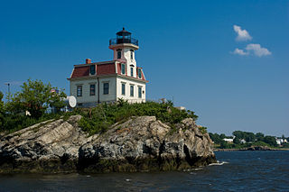
Pomham Rocks Light is a historic lighthouse in the Providence River about 200 yards (180 m) off the shoreline of the Riverside neighborhood of the city of East Providence, Rhode Island. It is the northernmost lighthouse in Narragansett Bay.
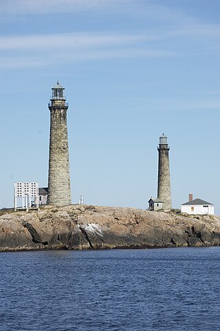
The Cape Ann Light Station on Thacher Island, off Cape Ann in Rockport, Massachusetts, is nationally significant as the last light station to be established under colonial rule and the first station in the United States to mark a navigational hazard rather than a harbor entrance. The current pair of lighthouses were built in 1861. They were both equipped with first order Fresnel lenses, which stood approximately 10 feet (3.0 m) high and weighed several tons (tonnes).

Plymouth Light, also known as Gurnet Light, is a historic lighthouse located on Gurnet Point at the entrance to Plymouth Bay in the town of Plymouth, Massachusetts. The light is accessible only by passing through the town of Duxbury, which lies to the north. The tower is located inside the earthworks of Fort Andrew, which existed in the Civil War, War of 1812, and Revolutionary War.

The Tarpaulin Cove Light is a historic lighthouse on Naushon Island, one of the Elizabeth Islands of southern Massachusetts. It is located in the town of Gosnold, Massachusetts. Built on the site of a light station first established privately in the 18th century, the current tower dates from 1891. A keeper's house built at the same time has not survived. The light is 78 feet (24 m) above Mean High Water, and its white light is visible for 9 nautical miles.

Borden Flats Light is a historic lighthouse on the Taunton River in Fall River, Massachusetts, US. It is a tower-on-caisson type known as a sparkplug lighthouse.
Ned Point Light is a historic lighthouse on Ned's Point Road in Mattapoisett, Massachusetts. The lighthouse was built in 1838 at a cost of approximately $5,000, and named after Ned Dexter, a local farmer. Under the supervision of a local builder, Leonard Hammond, the lighthouse was constructed with a birdcage-style lantern similar to Bird Island Light found in Marion, Massachusetts. The stone used for the lighthouse was all locally sourced, with most of it originating from nearby beaches. Inside, there are 32 granite steps that are cantilevered to the outside wall without the use of mortar. The original lantern used 11 whale oil lamps, each with its own parabolic reflector. The lamps and reflectors were replaced by a fifth order Fresnel lens in 1857, along with a change to an octagonal lantern. The Great Blizzard of 1888 significantly damaged the keeper's stone house, resulting in it being demolished and the building of a wooden replacement.

Bakers Island Light is a historic lighthouse on Bakers Island in Salem, Massachusetts. The station was originally established in 1791, with a daymark. This was replaced in 1798 by two lights atop a keeper's house, one at each end. After storm damage in 1815, an octagonal stone tower was constructed. The current round stone tower was added in 1820. The 1820 tower was taller, leading to the names "Ma" and "Pa". The two remained in service until 1926, when the older, shorter tower was removed.

Annisquam Harbor Light Station is a historic lighthouse on Wigwam Point in the Annisquam neighborhood of Gloucester, Massachusetts. It can be viewed from nearby Wingaersheek Beach, Gloucester. It lies on the Annisquam River and is one of the four oldest lighthouses to surround the Gloucester peninsula as well as; Eastern Point Light, Ten Pound Island Light, and Thacher Island Light.

The Newburyport Harbor Light, also known as Plum Island Light, built in 1788, is a historic lighthouse on Northern Boulevard in Newburyport, Massachusetts.

Hospital Point Range Front Light is a historic lighthouse at the end of Bayview Avenue in Beverly, Massachusetts. It forms the front half of a range which guides vessels toward Salem Harbor. The tower was added to the National Register of Historic Places as Hospital Point Light Station on September 28, 1987.
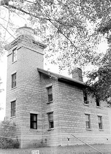
Sodus Point Light is a lighthouse that was built on Sodus Point on Lake Ontario, New York. The lighthouse has been replaced by a modern skeleton tower. The lighthouse tower is a square, pyramidal cast iron tower on a concrete and stone pier. It is white with red trim. There is a 21⁄2 story limestone keepers quarters that was built in 1871, which is currently used as a museum. The lighthouse is owned by the Village of Sodus Point, New York. There is a long-term lease with the Sodus Bay Historical Society to manage the lighthouse. The lighthouse is on the National Register of Historic Places, with reference #76001288, as Sodus Point Lighthouse. The pier and shore light served simultaneously from 1834 until 1901. The dwelling was used by the Coast Guard as housing until 1984. There is a 31⁄2 order Fresnel lens on display.

The Cuckolds Light, known as the Cuckolds Island Fog Signal and Light Station or just Cuckolds Light Station, is a lighthouse located on the eastern pair of islets known as the "Cuckolds" in Lincoln County, Maine, United States. The islets are southeast and in sight of Cape Island, that is just off the southern tip of Cape Newagen on Southport Island, south of Booth Bay, that leads to Boothbay Harbor, Maine.

Egg Rock Light is a lighthouse on Frenchman Bay, Maine. Built in 1875, it is one of coastal Maine's architecturally unique lighthouses, with a square tower projecting through the square keeper's house. Located on Egg Rock, midway between Mount Desert Island and the Schoodic Peninsula, it is an active aid to navigation, flashing red every 40 seconds. The light was listed on the National Register of Historic Places as Egg Rock Light Station in 1988.

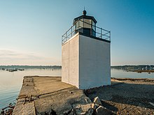
Fort Pickering Light, also known as Winter Island Light, is a lighthouse built in 1871 and discontinued by the Coast Guard in 1969. It was relit as a private aid to navigation by the City of Salem in 1983.