Dibulla, La Guajira

Last updated
Dibulla
town
Flag of Dibulla (La Guajira).svg
Coat of arms of Dibulla.png
Motto: 
The ideal place for rebirth
Colombia - La Guajira - Dibulla.svg
Location of the town and municipality of Dibulla in La Guajira Department.
Colombia location map.svg
Red pog.svg
Dibulla
Location in Colombia
Coordinates: 11°16′0″N73°18′3″W / 11.26667°N 73.30083°W / 11.26667; -73.30083
Country Flag of Colombia.svg  Colombia
Region Caribbean
Department La Guajira
Government
   Mayor Marlon Amaya Mejia (CC) [1]
Area
  Total1,847 km2 (713 sq mi)
Elevation
2 m (7 ft)
Population
 (2020 est.)
  Total39’069
  [2]
Time zone UTC-5
Climate Aw

Dibulla (Sometimes spelled Dibuya) is a town and municipality located in the Department of La Guajira, Colombia by the Caribbean Sea and the Sierra Nevada de Santa Marta mountains on the Guajira Peninsula. It was proclaimed municipality in 1995.

Contents

The town is mostly recognized for being the birthplace of renown vallenato composer Carlos Huertas and his song " El Cantor de Fonseca ".

Geography

Dibulla limits to the west with the Magdalena Department; to the north with the Caribbean Sea by the steps of the Sierra Nevada de Santa Marta mountains (northeastern side). Located 74 km away from La Guajira's capital Riohacha en route to the city of Santa Marta, it is crossed by the river of the same name, the Dibulla River and also the Jérez River.

The municipality has a total area of 1,847 km2 and its only 2 m above sea level. The average temperature is of 28 °C. Its main attraction relies on a recreational center called Maziruma, a beach resort. [3]

History

Province of Guanebucanes (Green), part of the Government of Santa Marta created in the year 1524. Provincia Guanebucan en la Gobernacion de Santa Marta 1500.png
Province of Guanebucanes (Green), part of the Government of Santa Marta created in the year 1524.

The area of present-day municipality of Dibuya was inhabited predominantly during the Pre-Columbian era by indigenous tribes pertaining to the Koguis and Guanebucanes ethnic groups descendants of the Tairona civilization with a direct influence from the Wayuu ethnic group. During the Spanish colonization of the Americas, the indigenous village of Yaharo was first seen by Spanish explorers upon reaching the coasts of the Guajira Peninsula in 1502. In 1525, Spanish explorer Rodrigo de Bastidas visited the Yaharo Town and registered an account of the village. [4] A year before, in 1524 Bastidas had created the Government of Santa Marta which covered an area from Cabo de la Vela to the mouth of the Magdalena River. [5]

Between 1609 and 1640, the Spanish colonizers imported some 800 or more African slaves. Most of these later escaped and formed Palenques. In 1679 the Government of Santa Marta offered these palenques their freedom in exchange of protecting the territory from English pirates. [6]

In 1846 then President of Colombia, Gen. Tomas Cipriano de Mosquera ordered the reestablishment of the government after the War of the Supremes civil war. Yaharo was renamed to Dibuya which translates from the Guanebucan language to "lagoon by the sea", lagoon which is located in the region of the Ramada. [7]

In 1872 Dibuya became a municipality seat or district by law 216 of this same year and was part of the Department of Magdalena. In 1886 this category was removed by interim governor of the department Luis Cotes by Decree 377 of February 17, 1886 when the United States of Colombia was dissolved. The Council of Riohacha formally created the Corregimiento of Dibuya on April 1, 1887. [8]

From the 1970s and until approximately 1989 two families from the Department of La Guajira; the Cárdenas and the Valdeblánquez engaged in a war for the control of the marijuana. The confrontation between the two families gained national attention and directly affected those family members living in Dibuya, as well as those living from Barranquilla and Santa Marta to Riohacha, Maicao and Valledupar in the Caribbean Region of Colombia. [9]

On December 5, 1995 the Department Assembly of La Guajira created the Municipality of Dibuya by Ordinance 030 of that same year. Cristian Montero Córdoba became its first appointed mayor by Decree 350 of December 28, 1995. [10]

Politics

Administrative divisions

The Municipality of Dibulla is made formed by five corregimientos, two inspecciones de policía (Police Inspections) and twenty nine veredas:

Dibulla neighborhoods

  • El Peru
  • La Marina
  • Las casitas
  • Miramar
  • Rincon Guapo
  • Tierra Baja

Corregimientos

  • Campana Nuevo
  • La Punta de los Remedios
  • Las Flores
  • Mingueo
  • Palomino
  • Rio Ancho

Veredas

  • Casa Aluminio
  • Chimgale
  • Cuatro Veredas
  • El Cerro Jerez
  • El Limonal
  • Larga La Vida
  • Mosca

Related Research Articles

<span class="mw-page-title-main">Cesar Department</span> Department of Colombia

Cesar Department or simply Cesar is a department of Colombia located in the north of the country in the Caribbean region, bordering to the north with the Department of La Guajira, to the west with the Department of Magdalena and Department of Bolivar, to the south with Department of Santander, to the east with the Department of North Santander, and further to the east with the country of Venezuela. The department capital city is Valledupar.

<span class="mw-page-title-main">Valledupar</span> Municipality and city in Caribbean, Colombia

Valledupar is a city and municipality in northeastern Colombia. It is the capital of Cesar Department. Its name, Valle de Upar, was established in honor of the Amerindian cacique who ruled the valley; Cacique Upar. The city lies between the mountains of the Sierra Nevada de Santa Marta and the Serranía del Perijá to the borders of the Guatapurí and Cesar rivers.

<span class="mw-page-title-main">Riohacha</span> District and city in Caribbean, Colombia

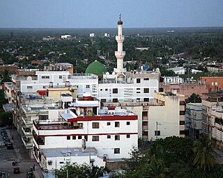
Riohacha is a city in the Riohacha Municipality in the northern Caribbean Region of Colombia by the mouth of the Ranchería River and the Caribbean Sea. It is the capital city of the La Guajira Department. It has a sandy beach waterfront.

<span class="mw-page-title-main">Maicao</span> Municipality and city in Caribbean, Colombia

Maicao is a city and municipality in the Department of La Guajira, northern Republic of Colombia. It is located 76 km from Riohacha, the capital of the department and is the second largest urban center near the border with Venezuela, after the city of Cúcuta.

<span class="mw-page-title-main">Municipalities of Colombia</span> Decentralized subdivisions of the Republic of Colombia

The municipalities of Colombia are decentralized subdivisions of the Republic of Colombia. Municipalities make up most of the departments of Colombia with 1,122 municipalities (municipios). Each one of them is led by a mayor (alcalde) elected by popular vote and represents the maximum executive government official at a municipality level under the mandate of the governor of their department which is a representative of all municipalities in the department; municipalities are grouped to form departments.

<span class="mw-page-title-main">Sogamoso</span> Municipality and city in Boyacá, Colombia

Sogamoso is a city in the department of Boyacá of Colombia. It is the capital of the Sugamuxi Province, named after the original Sugamuxi. Sogamoso is nicknamed "City of the Sun", based on the original Muisca tradition of pilgrimage and adoring their Sun god Sué at the Sun Temple. The city is located at an altitude of 2,569 metres (8,428 ft) on the Altiplano Cundiboyacense in the Eastern Ranges of the Colombian Andes.

<span class="mw-page-title-main">San Juan del Cesar</span> Municipality and town in Caribbean, Colombia

San Juan del Cesar is a municipality and town located in the La Guajira Department, Colombia.

<span class="mw-page-title-main">Caribbean region of Colombia</span>

The Caribbean region of Colombia or Caribbean coast region is in the north of Colombia and is mainly composed of 8 departments located contiguous to the Caribbean. It's the second most populated region in the country after Andean Region with approximately 11 million residents according to the Colombian Census 2018. The area covers a total land area of 110,000 km2 (42,000 sq mi), including the Archipelago of San Andrés, Providencia and Santa Catalina in the Caribbean Sea.

<span class="mw-page-title-main">La Guajira Department</span> Department of Colombia

La Guajira is a department of Colombia. It occupies most of the Guajira Peninsula in the northeast region of the country, on the Caribbean Sea and bordering Venezuela, at the northernmost tip of South America. The capital city of the department is Riohacha.

<span class="mw-page-title-main">Ranchería River</span> River in Colombia

The Ranchería River is a river located in northern La Guajira Department, Colombia. Born in the Sierra Nevada de Santa Marta southern steps flows south, abruptly turns northeast and then north where it finally flows into the Caribbean Sea. It is the main river of La Guajira Department and has great significance for the Wayuu people.

<span class="mw-page-title-main">Fonseca, La Guajira</span> Municipality and town in Caribbean, Colombia

Fonseca is a municipality located in the Colombian Department of La Guajira. The town celebrates the Festival del Retorno in honor of St Augustine with religious celebrations, vallenato music events and others.

<span class="mw-page-title-main">Uribia, La Guajira</span> Town in Caribbean, Colombia

Uribia is a town and municipality of the La Guajira department of Colombia. It is the youngest municipality of this Department since the year 2000. Northern Zone of the Cerrejón coal mines are located in this municipality. The municipality also contains the Serranía de Macuira mountain range which is an isolated low altitude mountain range in the middle of La Guajira Desert. One third of this mountain range is also a National Natural Park of Colombia.

<span class="mw-page-title-main">Albania, La Guajira</span> Town in Caribbean, Colombia

Albania is a town and municipality of the Colombian Department of La Guajira. Is the youngest municipality of this Department along with the town of Uribia and others, created on March 19, 2000. Albania neighbours and exclusive enclosed camp site for the Cerrejón coal mine workers and their families, named Mushaisa.

<span class="mw-page-title-main">Highways in Colombia</span> National highways in Colombia

Colombian geography presents formidable challenges to roadbuilders, who need to integrate its largest production centers deep within the Andes with major ports in both the Atlantic and Pacific oceans. All of this creates a heavy premium to roadbuilding, compared with the cost of building highways in flat terrain. Therefore, the Colombian government is undertaking a great effort in order to improve the highway system, under the name of Fourth Generation Highways, with the intent of updating major roads to international safety and speed standards. This project will be funded through both public and private capital, with a total worth of nearly US$23 billion, accounting to a yearly investment of 3% of national GDP, improving or building a grand total of over 8.000 km of roads. These roads are expected to improve Colombia's competitiveness in order to successfully take advantage of the many trade agreements signed in recent years.

<span class="mw-page-title-main">1st Division (Colombia)</span> Colombian National Army division

The 1st Division is a Colombian National Army division consisting on two brigades; The 2nd Brigade based in the city of Barranquilla and the 10th Armored Brigade based in the city of Valledupar. Its current commander is general Juan Bautista Yepez Bedoya, an infantry officer.

<span class="mw-page-title-main">Atanquez</span> Place in Cesar, Colombia

Atanquez or San Sebastian is a Colombian town and corregimiento of Valledupar in the Department of Cesar. Atanquez is located on the Sierra Nevada de Santa Marta mountain range at approximately 2,000 m over sea level. Atanquez is known for being predominantly inhabited by the indigenous ethnic group Kankuamos among others and mestizo groups.

<span class="mw-page-title-main">Riohacha Municipality</span> Municipality in Columbia

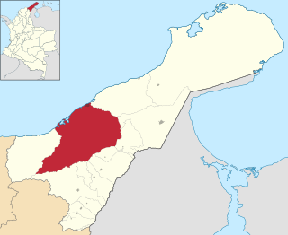
Riohacha Municipality is located on the Caribbean region of Colombia of La Guajira Department, Colombia. It extends over 3,120 km2 and has an urban part divided into 10 Communes, 14 Corregimientos and 8 Resguardos Indígenas. 7 of the indigenous regions belong to the Wayuu and one in the Sierra Nevada de Santa Marta region shared by the Kogi, the Wiwa, and the Ijka, a subtribe of the Arhuaco people.

<span class="mw-page-title-main">Palomino, Colombia</span> City in Caribbean, Colombia

Palomino is a small town on the Caribbean coast of Colombia located in the Guajira region of Colombia, approximately 70 km from Santa Marta and 90 km from Riohacha.

<span class="mw-page-title-main">Luis Antonio Robles</span>

Luis Antonio Robles Suárez also known as "El Negro Robles", was a Colombian lawyer and politician. He was the first Afro-Colombian to hold a cabinet-level ministry in Colombia serving as Secretary of the Treasury and Public Credit during the administration of President Aquileo Parra Gómez, as well as being the first Afro-Colombian Congressperson as Member of the Chamber of Representatives for Magdalena, and the first Afro-Colombian Governor of a Department, as the 16th President of the Sovereign State of Magdalena. He graduated a lawyer from Our Lady of the Rosary University in 1872, thus also becoming the first Afro-Colombian to ever serve as a lawyer in Colombia.

Colombia Migration is Colombia's border control agency responsible for monitoring and conducting migratory control within the framework of national sovereignty and in accordance with the law.

References

  1. (in Spanish) Colombian Registry of the Civil State: 2007 election results
  2. "Resultados y proyecciones (2005-2020) del censo 2005" . Retrieved 17 April 2020.
  3. (in Spanish) Government of La Guajira: Geography of Dibuya Archived 2007-08-13 at the Wayback Machine
  4. (in Spanish) Dibuya: History Archived 2012-07-15 at archive.today
  5. (in Spanish) Juan Friede, “La conquista del territorio y el poblamiento”, Manual de Historia de Colombia, 3 Vols., Vol. 1, Bogotá, Instituto Colombiano de Cultura, 1982, pp.116-222, p.131.
  6. (in Spanish) La guerra de los Cárdenas y los Valdeblánquez (1970-1989) Estudio de un conflicto mestizo en La Guajira by Simón Uribe Martínez and Nicolás Cárdenas Angel Archived 2015-01-22 at the Wayback Machine
  7. (in Spanish) Dibuya: History Archived 2012-07-15 at archive.today
  8. (in Spanish) Dibuya: History Archived 2012-07-15 at archive.today
  9. (in Spanish) La guerra de los Cárdenas y los Valdeblánquez (1970-1989) Estudio de un conflicto mestizo en La Guajira by Simón Uribe Martínez and Nicolás Cárdenas Angel Archived 2015-01-22 at the Wayback Machine
  10. (in Spanish) Dibuya: History Archived 2012-07-15 at archive.today

11°16′N73°18′W / 11.267°N 73.300°W / 11.267; -73.300