Fonseca, La Guajira

Last updated
Fonseca
Municipality and town
Flag of Fonseca (La Guajira).svg
Escudo de Fonseca (La Guajira).svg
Motto(s): 
"Volver a ti es repetir la dicha de nacer"
Colombia - La Guajira - Fonseca.svg
Location of the town and municipality of Fonseca in the Department of La Guajira.
Country Colombia
Region Caribbean
Department La Guajira
Government
   Mayor Hamilton García Peñaranda (Podemos) [1]
Area
   Municipality and town473.5 km2 (182.8 sq mi)
  Urban
5.46 km2 (2.11 sq mi)
Elevation
11.8 m (38.7 ft)
Population
 (2020 est.) [2] [3]
   Municipality and town44,544
  Density94/km2 (240/sq mi)
   Urban
39,662
  Urban density7,300/km2 (19,000/sq mi)
Time zone UTC-5
Climate Aw
Website
fonseca-guajira.gov.co/
*

Fonseca is a municipality located in the Colombian Department of La Guajira. The town celebrates the Festival del Retorno in honor of St Augustine with religious celebrations, vallenato music events and others.

Contents

Geography

The municipality of Fonseca has a total area of 622 square kilometres or 240 square miles at an altitude of 11 metres or 36 feet above sea level at the seat of the municipality. The municipality is on a depression in the valley of the Ranchería River which flows through the municipality from west to east, between the Sierra Nevada de Santa Marta and the Serranía del Perijá. [4] [5] [6]

Fonseca limits to the north with the municipality of Riohacha and Sierra Nevada de Santa Marta mountain range; to the south with the Bolivarian Republic of Venezuela and the Serranía del Perijá mountains; to the east with the municipality of Barrancas and to the west narrowly with the municipality of San Juan del Cesar. [6]

The average temperature throughout the year is 28 °C or 82.4 °F varying only by altitude due to the mountainous environment. [7] The municipality‘s climate ranges from hot semi-arid (Köppen BSh), as at the weather station of La Paulina, to tropical savanna (Aw) in wetter locations. There is a long though not intense wet season from April to November and a dry season from December to March with very little or no rain.

Climate data for La Paulina, Fonseca, La Guajira
MonthJanFebMarAprMayJunJulAugSepOctNovDecYear
Mean daily maximum °C (°F)33.2
(91.8)
34.1
(93.4)
34.2
(93.6)
34.2
(93.6)
34.0
(93.2)
34.9
(94.8)
35.3
(95.5)
35.0
(95.0)
34.5
(94.1)
33.8
(92.8)
33.0
(91.4)
32.4
(90.3)
34.1
(93.4)
Mean daily minimum °C (°F)22.1
(71.8)
22.1
(71.8)
22.4
(72.3)
22.9
(73.2)
23.5
(74.3)
24.0
(75.2)
24.0
(75.2)
23.7
(74.7)
23.1
(73.6)
22.9
(73.2)
23.0
(73.4)
22.4
(72.3)
23.0
(73.4)
Average rainfall mm (inches)7.4
(0.29)
1.7
(0.07)
11.0
(0.43)
68.5
(2.70)
93.9
(3.70)
96.4
(3.80)
70.2
(2.76)
99.9
(3.93)
138.2
(5.44)
111.0
(4.37)
87.1
(3.43)
27.0
(1.06)
812.3
(31.98)
Average rainy days (≥ 1 mm)10269881013129381
Source: Instituto de Hidrología, Meteorología y Estudios Ambientales [8]

History

The area of Fonseca was inhabited by different indigenous groups; Chimila, Tupe, Wayuu, Cariachile people and Motilon. [9]

There are two hypotheses about the foundation of Fonseca. One describes that by the year 1750 Catalan colonizer Agustín Fonseca and Italian José Agustín Parodi founded the village. [10]

Agustín Fonseca was the leader of a group of adventurers who settled by the Ranchería river, but in a rainy season the river flooded the area bringing diseases. They moved to a dryer place on what is supposedly the present-day main plaza of Fonseca. José Agustín Parodi was a captain of the Spanish Crown and arrived by orders of the Spanish monarchy. [9]

In 1773 the settlement of Fonseca was registered as jurisdiction of the Province of Santa Marta, only until 1967 La Guajira separated of Magdalena Department. On June 13, 1829 Fonseca became a municipality of the Intendencia of La Guajira by Decree 1954. [9] Fonseca became a municipality of the Department of La Guajira in 1954. [10]

Colombian armed conflict

Since the 1970s Barrancas has been influenced by the Colombian armed conflict because of its strategic location between the Sierra Nevada de Santa Marta, the Serranía del Perijá mountain ranges and the border with Venezuela. The Revolutionary Armed Forces of Colombia (FARC) through its Caribbean Bloc's 59th, 19th and 41st fronts and the National Liberation Army (ELN) guerrilla Gustavo Palmesano Front have practiced selective assassinations, kidnappings, extortions, forcedly recruitments, town sieges, arms and illegal drugs trafficking among others against the Colombian government and the civilian population. [11]

The United Self-Defense Forces of Colombia (AUC) appeared in the area in the early 2000s led by alias Jorge 40. After a violent presence in the area but also dissipating the guerrillas presence, the AUC demobilized in 2006. [11]

Politics

Administrative divisions

The municipality seat of Fonseca has some 32 neighborhoods mostly houses. The municipality also has three corregimientos; Conejo, El Hatico and Sitio Nuevo. Eight police inspections: Bangañitas, El Confuso, Los Altos, Sabaneta, Los Pondores, Cardonal, Trigo and Cañaboba. Some twenty veredas: El Porvenir, El Potrero, Jaguey, Puyalito, El Puy, Potrerito, Los Toquitos, Hatico Viejo, La Yaya, San Agustín, Puerto López, Las Bendiciones, Las Marimondas, Las Colonias, La Villa, Guamachal, Mamarongo, El Chorro and Mamonal. la mana, la union, arroyo hondo, sabana el medio san agustin, el puy, el toco, los toquitos. There is one indigenous reserve called Resguardo Indígena de Mayabangloma. [12]

Demographics

Population data pertaining to the municipality of Fonseca from the year 2000 to 2004.

YearUrbanRuralTotal [13]
200022,9233,12626,049
200123,7023,23226,934
200224,5083,34227,580
200325,3413,45628,797
200426,2033,54729,777

Culture

Fonseca celebrates the Festival del Retorno (Festival of the Return) every year in which people from Fonseca living in other towns, regions or countries are celebrated for their return to town. [14]

Related Research Articles

<span class="mw-page-title-main">Cesar Department</span> Department of Colombia

Cesar Department or simply Cesar is a department of Colombia located in the north of the country in the Caribbean region, bordering to the north with the Department of La Guajira, to the west with the Department of Magdalena and Department of Bolivar, to the south with Department of Santander, to the east with the Department of North Santander, and further to the east with the country of Venezuela. The department capital city is Valledupar.

<span class="mw-page-title-main">Valledupar</span> Municipality and city in Caribbean, Colombia

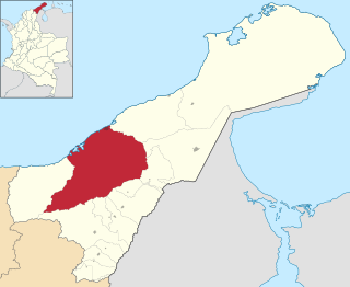
Valledupar is a city and municipality in northeastern Colombia. It is the capital of Cesar Department. Its name, Valle de Upar, was established in honor of the Amerindian cacique who ruled the valley; Cacique Upar. The city lies between the mountains of the Sierra Nevada de Santa Marta and the Serranía del Perijá to the borders of the Guatapurí and Cesar rivers.

<span class="mw-page-title-main">Riohacha</span> District and city in Caribbean, Colombia

Riohacha is a city in the Riohacha Municipality in the northern Caribbean Region of Colombia by the mouth of the Ranchería River and the Caribbean Sea. It is the capital city of the La Guajira Department. It has a sandy beach waterfront.

<span class="mw-page-title-main">Guajira Peninsula</span> Geographic feature in northeastern Colombia and northwestern Venezuela

The Guajira Peninsula is a peninsula in northern Colombia and northwestern Venezuela in the Caribbean. It is the northernmost peninsula in South America and has an area of 25,000 km2 (9,700 sq mi) extending from the Manaure Bay (Colombia) to the Calabozo Ensenada in the Gulf of Venezuela (Venezuela), and from the Caribbean to the Serranía del Perijá mountains range.

<span class="mw-page-title-main">San Juan del Cesar</span> Municipality and town in Caribbean, Colombia

San Juan del Cesar is a municipality and town located in the La Guajira Department, Colombia.

<span class="mw-page-title-main">Cesar River</span> River in Cesar Department, Colombia

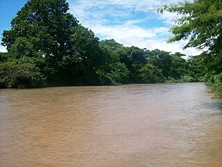
The Cesar River is a river in northern Colombia which is a part of the Magdalena Basin. It flows through the Cesar-Ranchería Basin and separates the Sierra Nevada de Santa Marta from the mountain ranges of the Serranía del Perijá, an extension of the Cordillera Oriental. It flows north to south, down from the Sierra Nevada de Santa Marta in the Guajira Department onto the Cesar Department and flowing into the Zapatosa Marsh where it turns to the southwest and discharges into the Magdalena River after 280 kilometers. Valledupar is the only major city on its route.

<span class="mw-page-title-main">Agustín Codazzi, Cesar</span> Municipality and town in Caribbean, Colombia

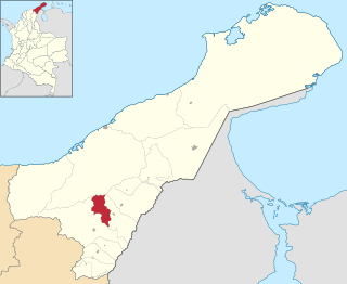
Agustín Codazzi, or Codazzi, is a city and municipality of the Department of Cesar in Colombia. It was founded in 1784 by the Spanish Captain Salvador Felix de Arias with the name of El Pueblito del Espiritu Santo but later renamed after the Italian cartographer, Giovanni Battista Agostino Codazzi, who died in this place in 1859. It is located along the Serranía del Perijá, covering some of the area pertaining to the valley of the Cesar River.

<span class="mw-page-title-main">La Guajira Department</span> Department of Colombia

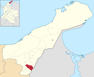
La Guajira is a department of Colombia. It occupies most of the Guajira Peninsula in the northeast region of the country, on the Caribbean Sea and bordering Venezuela, at the northernmost tip of South America. The capital city of the department is Riohacha.

<span class="mw-page-title-main">Villanueva, La Guajira</span> Municipality and town in Caribbean, Colombia

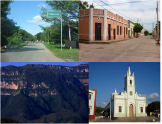
Villanueva is a town and municipality located in the northern Department of La Guajira, Colombia. Villanueva is known in Colombia for being the cradle of many vallenato singers and composers. The economy of the town relies heavily on agriculture and farming.

<span class="mw-page-title-main">Ranchería River</span> River in Colombia

The Ranchería River is a river located in northern La Guajira Department, Colombia. Born in the Sierra Nevada de Santa Marta southern steps flows south, abruptly turns northeast and then north where it finally flows into the Caribbean Sea. It is the main river of La Guajira Department and has great significance for the Wayuu people.

<span class="mw-page-title-main">Barrancas, La Guajira</span> Town in Caribbean, Colombia

Barrancas is a town and municipality of the Colombian Department of La Guajira. The municipality of Barrancas is located to the left margin of the Ranchería River in a valley formed between the Sierra Nevada de Santa Marta mountains and the Serranía del Perijá. Barrancas has a total area of 742 km2 and at 40 meters over sea level. The average temperature is 28 °C throughout the year and distances from the capital of the Department of La Guajira, Riohacha. It became a municipality in 1892.

<span class="mw-page-title-main">El Molino, La Guajira</span> Town in Caribbean, Colombia

El Molino is a town and municipality located in the Colombian Department of La Guajira.

<span class="mw-page-title-main">Uribia, La Guajira</span> Town in Caribbean, Colombia

Uribia is a town and municipality of the La Guajira department of Colombia. It is the youngest municipality of this Department since the year 2000. Northern Zone of the Cerrejón coal mines are located in this municipality. The municipality also contains the Serranía de Macuira mountain range which is an isolated low altitude mountain range in the middle of La Guajira Desert. One third of this mountain range is also a National Natural Park of Colombia.

<span class="mw-page-title-main">Albania, La Guajira</span> Town in Caribbean, Colombia

Albania is a town and municipality of the Colombian Department of La Guajira. Is the youngest municipality of this Department along with the town of Uribia and others, created on March 19, 2000. Albania neighbours and exclusive enclosed camp site for the Cerrejón coal mine workers and their families, named Mushaisa.

<span class="mw-page-title-main">Distracción, La Guajira</span> Town in Caribbean, Colombia

Distracción is a town and municipality in the Colombian Department of La Guajira. Founded in 1845 by a man from neighboring Barrancas named Antonio María Vidal on the right margin of the Ranchería River.

The History of Valledupar refers to the historical events related to the Colombian city of Valledupar. The region of what is now Valledupar was prior to the Spanish conquest of the Americas inhabited by numerous indigenous tribes pertaining to three major language families; the Arawaks, Kalina (Caribs) and Chibchas.

<span class="mw-page-title-main">Riohacha Municipality</span> Municipality in Columbia

Riohacha Municipality is located on the Caribbean region of Colombia of La Guajira Department, Colombia. It extends over 3,120 km2 and has an urban part divided into 10 Communes, 14 Corregimientos and 8 Resguardos Indígenas. 7 of the indigenous regions belong to the Wayuu and one in the Sierra Nevada de Santa Marta region shared by the Kogi, the Wiwa, and the Ijka, a subtribe of the Arhuaco people.

<span class="mw-page-title-main">Cesar-Ranchería Basin</span> Geologic formation in Colombia

The Cesar-Ranchería Basin is a sedimentary basin in northeastern Colombia. It is located in the southern part of the department of La Guajira and northeastern portion of Cesar. The basin is bound by the Oca Fault in the northeast and the Bucaramanga-Santa Marta Fault in the west. The mountain ranges Sierra Nevada de Santa Marta and the Serranía del Perijá enclose the narrow triangular intermontane basin, that covers an area of 11,668 square kilometres (4,505 sq mi). The Cesar and Ranchería Rivers flow through the basin, bearing their names.

<span class="mw-page-title-main">La Guajira Terrane</span> Geological province in Colombia

La Guajira Terrane is one of the geological provinces (terranes) of Colombia. The terrane, dating to the Late Cretaceous, is situated on the North Andes Plate and borders the Caribbean, Tahamí and Chibcha Terranes along the Bucaramanga-Santa Marta Fault. The southern boundary is formed by the Oca Fault with the Chibcha Terrane.

<span class="mw-page-title-main">Chibcha Terrane</span>

The Chibcha Terrane, named after Chibcha, is the largest of the geological provinces (terranes) of Colombia. The terrane, the oldest explored domains of which date to the Meso- to Neoproterozoic, is situated on the North Andes Plate. The megaregional Romeral Fault System forms the contact of the terrane with the Tahamí Terrane. The contact with the Caribbean and La Guajira Terranes is formed by the regional Bucaramanga-Santa Marta Fault. The northeastern boundary is formed by the regional Oca Fault, bounding the La Guajira Terrane. The terrane is emplaced over the Río Negro-Juruena Province of the Amazonian Craton along the megaregional Eastern Frontal Fault System.

References

  1. (in Spanish) Colombian Registry of the Civil State: 2007 election results
  2. "Resultados y proyecciones (2005-2020) del censo 2005" . Retrieved 17 April 2020.
  3. Citypopulation.de Population of Fonseca municipality
  4. (in Spanish) Government of La Guajira: Geography of Fonseca Archived 2007-08-13 at the Wayback Machine
  5. (in Spanish) Fonseca Developing Plan 2004: Area and Location [ permanent dead link ]
  6. 1 2 "Fonseca: Geography" (in Spanish). Archived from the original on 2012-07-09. Retrieved 2008-03-26.
  7. "Fonseca: Climate" (in Spanish). Archived from the original on 2012-07-09. Retrieved 2008-03-26.
  8. "Data". www.ideam.gov.co. Archived from the original on 2016-08-15. Retrieved 2020-06-23.
  9. 1 2 3 "Fonseca: History" (in Spanish). Archived from the original on 2012-07-09. Retrieved 2008-03-26.
  10. 1 2 (in Spanish) Government of La Guajira: History of Fonseca Archived 2007-08-13 at the Wayback Machine
  11. 1 2 (in Spanish) Government of Colombia - Human rights in La Guajira Archived 2008-05-29 at the Wayback Machine
  12. (in Spanish) Fonseca Development Plan 2004: Sub-duvisions [ permanent dead link ]
  13. (in Spanish) Fonseca Development Plan 2004: demography [ permanent dead link ]
  14. (in Spanish) mifonseca.net: Festival del Retorno Archived 2007-02-25 at the Wayback Machine

10°50′N72°50′W / 10.833°N 72.833°W / 10.833; -72.833