Distress signal

Last updated

A distress signal, also known as a distress call, is an internationally recognized means for obtaining help. Distress signals are communicated by transmitting radio signals, displaying a visually observable item or illumination, or making a sound audible from a distance.

Contents

A distress signal indicates that a person or group of people, watercraft, aircraft, or other vehicle is threatened by a serious or imminent danger and requires immediate assistance. [1] :PCG D−3 Use of distress signals in other circumstances may be against local or international law. An urgency signal is available to request assistance in less critical situations.

For distress signalling to be the most effective, two parameters must be communicated:

For example, a single aerial flare alerts observers to the existence of a vessel in distress somewhere in the general direction of the flare sighting on the horizon but extinguishes within one minute or less. A hand-held flare burns for three minutes and can be used to localize or pinpoint more precisely the exact location or position of the party in trouble. An EPIRB both notifies or alerts authorities and at the same time provides position indication information.

Maritime

Distress signals at sea are defined in the International Regulations for Preventing Collisions at Sea and in the International Code of Signals. Mayday signals must only be used where there is grave and imminent danger to life. Otherwise, urgent signals such as pan-pan can be sent. Most jurisdictions have large penalties for false, unwarranted, or prank distress signals. The alerts are of utmost importance in ensuring the safety of life at sea, and are governed by international maritime law, specifically the International Convention for the Safety of Life at Sea (SOLAS). [2]

Distress can be indicated by any of the following officially sanctioned methods:

Distress Signals Distress Signals.png
Distress Signals
Smoke signal Smoke signal 1.jpg
Smoke signal

A floating man-overboard pole or dan buoy can be used to indicate that a person is in distress in the water and is ordinarily equipped with a yellow and red flag (international code of signals flag "O") and a flashing lamp or strobe light.

In North America, marine search and rescue agencies in Canada and the United States also recognize certain other distress signals:

Automated radio signals

In addition, distress can be signaled using automated radio signals such as a Search and Rescue Transponder (SART) which response to 9 GHz radar signal, or an Emergency Position-Indicating Radio Beacon (EPIRB) which operates in the 406 MHz radiofrequency. EPIRB signals are received and processed by a constellation of satellites known as Cospas-Sarsat. Older EPIRBs that use 121.5 MHz are obsolete. Many regulators require vessels that proceed offshore to carry an EPIRB.

Many EPIRBs have an in-built Global Positioning System receiver. When activated these EPIRBs rapidly report the latitude and longitude of the emergency accurate to within 120 m (390 ft). The position of non-GPS EPIRBs is determined by the orbiting satellites, this can take ninety minutes to five hours after activation and is accurate to within 5 km (3.1 mi). Marine safety authorities recommend the use of GPS-equipped EPIRBs. [3]

A miniaturized EPIRB capable of being carried in crew members' clothing is called a Personal Locator Beacon (PLB). Regulators do not view them as a substitute for a vessel's EPIRB. In situations with a high risk of "man overboard", such as open ocean yacht racing, PLBs may be required by the event's organizers. PLBs are also often carried during risky outdoor activities on the land.

EPIRBs and PLBs have a unique identification number (UIN or "HexID"). A purchaser should register their EPIRB or PLB with the national search and rescue authority; this is free in most jurisdictions. EPIRB registration allows the authority to alert searchers of the vessel's name, label, type, size, and paintwork; to promptly notify next-of-kin, and to quickly resolve inadvertent activations.

A DSC radio distress signal can include the position if the lat/long are manually keyed into the radio or if a GPS-derived position is passed electronically directly into the radio.

Mayday

A Mayday message consists of the word "mayday" spoken three times in succession, which is the distress signal, followed by the distress message, which should include:

Unusual or extraordinary appearance

When none of the above-described officially sanctioned signals are available, attention for assistance can be attracted by anything that appears unusual or out of the ordinary, such as a jib sail hoisted upside down.

During daylight hours when the sun is visible, a heliograph mirror can be used to flash bright, intense sunlight. Battery-powered laser lights the size of small flashlights (electric torches) are available for use in emergency signaling.

Inverted flags

For hundreds of years inverted national flags were commonly used as distress signals. [4] However, for some countries' flags it is difficult (e.g., Spain, South Korea, United Kingdom) or impossible (e.g., Japan, Thailand, and Israel) to determine whether they are inverted. Other countries have flags that are inverses of each other; for example, the Polish flag is white on the top half and red on the bottom, while Indonesia's and Monaco's flags are the opposite—i.e., top half red, the bottom half white. A ship flying no flags may also be understood to be in distress. [5] For one country, the Philippines, an inverted flag is a symbol of war rather than distress. [6]

If any flag is available, distress may be indicated by tying a knot in it and then flying it upside-down, making it into a wheft . [7]

Device loss and disposal

To avoid pointless searches some devices must be reported when lost. This particularly applies to EPIRBs, lifebuoys, rafts, and devices marked with the vessel's name and port.

Expired flares should not be set off, as this indicates distress. Rather, most port authorities offer disposal facilities for expired distress pyrotechnics. In some areas special training events are organized, where the flares can be used safely.

EPIRBs must not be disposed of into general waste as discarded EPIRBs often trigger at the waste disposal facility. In 2013, the majority of EPIRB activations investigated by the Australian Maritime Safety Authority were due to the incorrect disposal of obsolete 121.5 MHz EPIRB beacons. [8]

Aviation

The civilian aircraft frequency for voice distress alerting is 121.5 MHz. Military aircraft use 243 MHz (which is a harmonic of 121.5 MHz, and therefore civilian beacons transmit on this frequency as well). Aircraft can also signal an emergency by setting one of several special transponder codes, such as 7700.

The COSPAS/SARSAT signal can be transmitted by an Electronic Locator Transmitter or ELT, which is similar to a marine EPIRB on the 406 MHz radiofrequency. (Marine EPIRBs are constructed to float, while an aviation ELT is constructed to be activated by a sharp deceleration and is sometimes referred to as a Crash Position Indicator or CPI).

A "triangular distress pattern" is a rarely used flight pattern flown by aircraft in distress but without radio communications. The standard pattern is a series of 120° turns.

Ground Air Emergency Codes

Visual code used by survivors in the U.S. Ground-Air Visual Code for Use by Survivors.png
Visual code used by survivors in the U.S.
Visual code used by ground search parties in the U.S. Ground-Air Visual Code for use by Ground Search Parties.png
Visual code used by ground search parties in the U.S.

Ground-Air Emergency Codes are distress signals used by crashed pilots and military personnel to send signals from the ground to an aircraft. [9] [10]

Schwarzwald

The recognized mountain distress signals are based on groups of three, or six in the UK and the European Schwarzwald. A distress signal can be three fires or piles of rocks in a triangle, three blasts on a whistle, three shots from a firearm, or three flashes of light, in succession followed by a one-minute pause and repeated until a response is received. Three blasts or flashes is the appropriate response.

In the Schwarzwald, the recommended way to signal distress is the Schwarzwald distress signal: give six signals within a minute, then pause for a minute, repeating this until rescue arrives. A signal may be anything visual (waving clothes or lights, use of a signal mirror) or audible (shouts, whistles, etc.). The rescuers acknowledge with three signals per minute.

In practice, either signal pattern is likely to be recognized in most popular mountainous areas as nearby climbing teams are likely to include Europeans or North Americans.

Signal for "yes, I need help" Ground to air signaling - yes.jpg
Signal for "yes, I need help"

To communicate with a helicopter in sight, raise both arms (forming the letter Y) to indicate "Yes" or "I need help", or stretch one arm up and one down (imitating the letter N) for "No" or "I do not need help". If semaphore flags are available, they can be used to communicate with rescuers.

Ground beacons

The COSPAS-SARSAT 406 MHz radiofrequency distress signal can be transmitted by hikers, backpackers, trekkers, mountaineers and other ground-based remote adventure seekers and personnel working in isolated backcountry areas using a small, portable Personal Locator Beacon or PLB.

See also

Related Research Articles

<span class="mw-page-title-main">Emergency position-indicating radiobeacon</span> Distress radio beacon, a tracking transmitter that is triggered during an accident

An emergency position-indicating radiobeacon (EPIRB) is a type of emergency locator beacon for commercial and recreational boats, a portable, battery-powered radio transmitter used in emergencies to locate boaters in distress and in need of immediate rescue. In the event of an emergency, such as a ship sinking or medical emergency onboard, the transmitter is activated and begins transmitting a continuous 406 MHz distress radio signal, which is used by search-and-rescue teams to quickly locate the emergency and render aid. The signal is detected by satellites operated by an international consortium of rescue services, COSPAS-SARSAT, which can detect emergency beacons anywhere on Earth transmitting on the distress frequency of 406 MHz. The satellites calculate the position or utilize the GPS coordinates of the beacon and quickly passes the information to the appropriate local first responder organization, which performs the search and rescue. As Search and Rescue approach the search areas, they use Direction Finding (DF) equipment to locate the beacon using the 121.5 MHz homing signal, or in newer EPIRBs, the AIS location signal. The basic purpose of this system is to help rescuers find survivors within the so-called "golden day" during which the majority of survivors can usually be saved. The feature distinguishing a modern EPIRB, often called GPIRB, from other types of emergency beacon is that it contains a GPS receiver and broadcasts its position, usually accurate within 100 m (330 ft), to facilitate location. Previous emergency beacons without a GPS can only be localized to within 2 km (1.2 mi) by the COSPAS satellites and relied heavily upon the 121.5 MHz homing signal to pin-point the beacons location as they arrived on scene.

<span class="mw-page-title-main">SOS</span> International Morse code distress signal

SOS is a Morse code distress signal, used internationally, originally established for maritime use. In formal notation SOS is written with an overscore line, to indicate that the Morse code equivalents for the individual letters of "SOS" are transmitted as an unbroken sequence of three dots / three dashes / three dots, with no spaces between the letters. In International Morse Code three dots form the letter "S" and three dashes make the letter "O", so "S O S" became a common way to remember the order of the dots and dashes. IWB, VZE, 3B, and V7 form equivalent sequences, but traditionally SOS is the easiest to remember.

<span class="mw-page-title-main">Marine VHF radio</span> Radios operating in the very high frequency maritime mobile band

Marine VHF radio is a worldwide system of two way radio transceivers on ships and watercraft used for bidirectional voice communication from ship-to-ship, ship-to-shore, and in certain circumstances ship-to-aircraft. It uses FM channels in the very high frequency (VHF) radio band in the frequency range between 156 and 174 MHz, designated by the International Telecommunication Union as the VHF maritime mobile band. In some countries additional channels are used, such as the L and F channels for leisure and fishing vessels in the Nordic countries. Transmitter power is limited to 25 watts, giving them a range of about 100 kilometres.

The Global Maritime Distress and Safety System (GMDSS) is a worldwide system for automated emergency signal communication for ships at sea developed by the United Nations' International Maritime Organization (IMO) as part of the SOLAS Convention.

The aircraft emergency frequency is a frequency used on the aircraft band reserved for emergency communications for aircraft in distress. The frequencies are 121.5 MHz for civilian, also known as International Air Distress (IAD) or VHF Guard, and 243.0 MHz—the second harmonic of VHF guard—for military use, also known as Military Air Distress (MAD) or UHF Guard. Earlier emergency locator transmitters (ELTs) used the guard frequencies to transmit, but an additional frequency of 406 MHz is used by a more modern emergency locator transmitter.

<span class="mw-page-title-main">International Cospas-Sarsat Programme</span> International satellite-aided search and rescue initiative

The International Cospas-Sarsat Programme is a satellite-aided search and rescue (SAR) initiative. It is organized as a treaty-based, nonprofit, intergovernmental, humanitarian cooperative of 45 nations and agencies. It is dedicated to detecting and locating emergency locator radio beacons activated by persons, aircraft or vessels in distress, and forwarding this alert information to authorities that can take action for rescue. Member countries support the distribution of distress alerts using a constellation of around 65 satellites orbiting the Earth which carry transponders and signal processors capable of locating an emergency beacon anywhere on Earth transmitting on the Cospas-Sarsat frequency of 406 MHz.

<span class="mw-page-title-main">2182 kHz</span> Radio distress frequency

2182 kHz is a radio frequency designed exclusively for distress calls and related calling operations in the maritime service.

A Mountain Locator Unit or MLU was a radio transmitter for use by mountain climbers as an emergency locator beacon when the wearer needs rescue.

<span class="mw-page-title-main">Radio beacon</span> Radio transmitter to identify a location for navigation aid

In navigation, a radio beacon or radiobeacon is a kind of beacon, a device that marks a fixed location and allows direction-finding equipment to find relative bearing. But instead of employing visible light, radio beacons transmit electromagnetic radiation in the radio wave band. They are used for direction-finding systems on ships, aircraft and vehicles.

The Ship Security Alert System (SSAS) is provided to a ship for the purpose of transmitting a security alert to the shore to indicate to a competent authority that the security of the ship is under threat or has been compromised. In case of attempted piracy or terrorism, the ship's SSAS beacon can be activated by the crew to continuously send silent alerts to predefined recipients. Technically, the SSAS consists of a GPS receiver linked to a transmitter, a power supply, software and activation buttons.

The Joint Rescue Coordination Centre Victoria (JRCC Victoria) is a rescue coordination centre operated by the 1 Canadian Air Division (Canadian Armed Forces) and staffed by personnel of the Royal Canadian Air Force (RCAF) and the Canadian Coast Guard (CCG).

An international distress frequency is a radio frequency that is designated for emergency communication by international agreement.

ENOS stands for "Elektronisches Notruf- und Ortungssystem" – "Electronic Rescue and Location System" - a system developed in Germany for use by divers at sea. ENOS allows people in distress to signal their location when drifting on the ocean's surface so they can be quickly located and rescued. Although the system was especially developed for scuba diving it can also be used for other water sports like windsurfing, jet skiing, sailing and boating.

<span class="mw-page-title-main">Survival radio</span> Small radios carried to facilitate rescue in an emergency

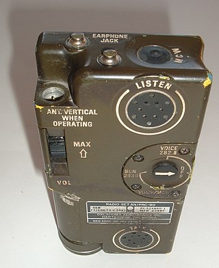
Survival radios are carried by pilots and search and rescue teams to facilitate rescue in an emergency. They are generally designed to transmit on international distress frequencies. Maritime systems have been standardized under the Global Maritime Distress Safety System. Civil and military organisation's utilized different frequencies to communicate and no infringement on either sector would take place. For emergencies involving civilian aircraft, the radio frequency used is VHF 121.5 MHz and for military aircraft incidents, the frequency used is UHF 243 MHz.

<span class="mw-page-title-main">Joint Rescue Coordination Centre Halifax</span> Canadian rescue coordination centre

The Joint Rescue Coordination Centre Halifax is a rescue coordination centre operated by the Royal Canadian Air Force (RCAF) and the Canadian Coast Guard (CCG).

A Satellite Emergency Notification Device or SEND is a portable emergency notification and locating device which uses commercial satellite systems rather than the COSPAS-SARSAT satellite system. An example of this device is SPOT.

The Joint Rescue Coordination Centre Trenton is a rescue coordination centre operated by the Royal Canadian Air Force (RCAF) and the Canadian Coast Guard (CCG).

An emergency locator beacon is a radio beacon, a portable battery powered radio transmitter, used to locate airplanes, vessels, and persons in distress and in need of immediate rescue. Various types of emergency locator beacons are carried by aircraft, ships, vehicles, hikers and cross-country skiers. In case of an emergency, such as the aircraft crashing, the ship sinking, or a hiker becoming lost, the transmitter is deployed and begins to transmit a continuous radio signal, which is used by search and rescue teams to quickly find the emergency and render aid. The purpose of all emergency locator beacons is to help rescuers find survivors within the so-called "golden day", the first 24 hours following a traumatic event, during which the majority of survivors can usually be saved.

NOAA-14, also known as NOAA-J before launch, was an American weather satellite operated by the National Oceanic and Atmospheric Administration (NOAA). NOAA-14 continued the third-generation operational, Polar Orbiting Environmental Satellite (POES) series operated by the National Environmental Satellite Service (NESS) of the National Oceanic and Atmospheric Administration (NOAA). NOAA-14 continued the series of Advanced TIROS-N (ATN) spacecraft begun with the launch of NOAA-8 (NOAA-E) in 1983.

The Breitling Emergency is a luxury watch produced by Breitling SA. It contains a radio transmitter for civil aviation use, which broadcasts on the 121.5 MHz distress frequency and serves as a backup for ELT-type airborne beacons. For military users, the Emergency has a miniaturized transmitter operating on the 243.0 MHz military aviation emergency frequency. Under normal conditions—flat terrain or calm seas—the signal can be picked up at a range of up to 90 nautical miles (170 km) by search aircraft flying at 20,000 feet (6,100 m). Since February 2009, the Cospas-Sarsat Satellite System has not monitored the 121.5/243.0 MHz frequency; however, the signal transmitted by the Emergency was never strong enough to be picked up by satellite, and Breitling has announced that, as these frequencies will still be monitored by aviation, particularly during the localization phase of a rescue attempt, there are no plans to modify the signal's frequency.

References

  1. Aeronautical Information Manual, U.S. Federal Aviation Administration, 2016
  2. "Distress Alerts". Maritime Dictionary. Retrieved 23 November 2023.
  3. "GPS versus Non-GPS: A comparison of GPS vs non-GPS 406 MHz distress beacons". Australian Maritime Safety Authority. Retrieved 21 March 2014.
  4. For example, 36 U.S. Code §176(a) provides: "The flag should never be displayed with the union down, except as a signal of dire distress in instances of extreme danger to life or property."
  5. "Slave Ship Mutiny Program Transcript" Archived 15 November 2010 at the Wayback Machine . Educational Broadcasting Corporation. 2010. Retrieved 2012-02-15.
  6. "U.S. Apologizes for flying Philippine flag upside down". Reuters. 27 September 2010.
  7. "Flying flags upside down". Allstates-flag.com. Archived from the original on 13 December 2009. Retrieved 27 July 2009.
  8. Gaden, Phil. "A 406Mhz beacon is your best chance of being rescued". Australian Maritime Safety Authority. Archived from the original on 12 December 2013. Retrieved 21 March 2014.
  9. The Handbook Of The SAS And Elite Forces. How The Professionals Fight And Win. Edited by Jon E. Lewis. p.185-Tactics And Techniques, Evasion, Capture And Escape. Robinson Publishing Ltd 1997. ISBN   1-85487-675-9
  10. "International Ground-to-Air Signaling Code". December 2017.