
A borough is an administrative division in various English-speaking countries. In principle, the term borough designates a self-governing walled town, although in practice, official use of the term varies widely.

The Hague is a city and municipality of the Netherlands, situated on the west coast facing the North Sea. The Hague is the country's administrative centre and its seat of government, and while the official capital of the Netherlands is Amsterdam, The Hague has been described as the country's de facto capital. The Hague is also the capital of the province of South Holland, and the city hosts both the International Court of Justice and the International Criminal Court.
A township is a kind of human settlement or administrative subdivision, with its meaning varying in different countries.

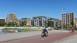
Almere is a planned city and municipality in the province of Flevoland, Netherlands across the IJmeer from Amsterdam.

Zoetermeer is a city in the Western Netherlands, in the province of South Holland. The municipality covers an area of 37.05 km2 (14.31 sq mi) of which 2.60 km2 (1.00 sq mi) is water. A small village until the late 1960s, it had 6,392 inhabitants in 1950. By 2013 this had grown to 123,328, making it the third largest population centre in the province of South Holland, after Rotterdam and The Hague. While now a city in its own right, Zoetermeer started out as a suburb of The Hague and is still a part of the Greater The Hague urban area.
A district is a type of administrative division that in some countries is managed by the local government. Across the world, areas known as "districts" vary greatly in size, spanning regions or counties, several municipalities, subdivisions of municipalities, school district, or political district.
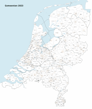
As of 1 January 2023, there are 342 municipalities and three special municipalities in the Netherlands. The latter is the status of three of the six island territories that make up the Dutch Caribbean. Municipalities are the second-level administrative division, or public bodies, in the Netherlands and are subdivisions of their respective provinces. Their duties are delegated to them by the central government and they are ruled by a municipal council that is elected every four years. Municipal mergers have reduced the total number of municipalities by two-thirds since the first official boundaries were created in the mid 19th century. Municipalities themselves are informally subdivided into districts and neighbourhoods for administrative and statistical purposes.

Amsterdam-Zuidoost is a borough (stadsdeel) of Amsterdam, Netherlands. It consists of four residential neighborhoods—Bijlmermeer, Venserpolder, Gaasperdam and Driemond—as well as the Amstel III/Bullewijk Business Park and the Amsterdam Arena entertainment and shopping district.

The City Center of The Hague is the oldest and, with a population of 104,658 inhabitants, the second largest of The Hague's eight districts, consisting of nine neighbourhoods. Two railways stations can be found in the city center: Den Haag Centraal and Den Haag Hollands Spoor.
A stadsdeel is the name used for urban or municipality districts in some of the larger municipalities of the Netherlands.

Loosduinen is a former village in the Netherlands that was a municipality unto itself until 1923, when it was annexed by The Hague and subsequently became a district of the city.

Den Haag HS, an abbreviation of the original name Den Haag Hollands Spoor, is the oldest train station in The Hague, South Holland, Netherlands, located on the Amsterdam–Haarlem–Rotterdam railway.

Amsterdam-Oost is a borough of Amsterdam, Netherlands, established in May 2010 after a merger of the former boroughs of Zeeburg and Oost-Watergraafsmeer. In 2013, the borough had almost 123,000 inhabitants.

Amsterdam-Zuid is a borough (stadsdeel) of Amsterdam, Netherlands. The borough was formed in 2010 as a merger of the former boroughs Oud-Zuid and Zuideramstel. The borough has almost 138,000 inhabitants (2013). With 8,500 homes per square kilometer, it is one of the most densely populated boroughs of Amsterdam. It has the highest income per household of all boroughs in Amsterdam.
Amsterdam Nieuw-West is a borough comprising the westernmost neighbourhoods of the city of Amsterdam, Netherlands. It was created in 2010 after a merger of the former boroughs Osdorp, Geuzenveld-Slotermeer and Slotervaart. In 2017, the borough had almost 150,000 inhabitants.

Amsterdam-Centrum is the inner-most borough and historical city centre of Amsterdam, Netherlands, containing the majority of the city's landmarks. Established in 2002, Amsterdam-Centrum was the last area in the city to be granted the status of self-governing borough. The borough is only 8.04 km2 large and covers the old innercity and the UNESCO-listed Amsterdam canal belt. In 2013, the borough had approximately 85,000 inhabitants, who on average had the second-highest income per household in the city and one of the highest in the country.

The Archipelbuurt is a neighbourhood in the Centrum district of The Hague, Netherlands. It has 5,764 inhabitants and covers an area of 87.1 hectares (0.336 sq mi). Built primarily between 1860 and 1890, the neighbourhood is known for its Neo-Renaissance architecture and wide avenues and streets. Important streets in the Archipelbuurt include the Javastraat, the Surinamestraat, the Scheveningseweg, the Nassauplein and the Burgemeester De Monchyplein. A Jewish graveyard, a chapel and a former city hall of The Hague can be found in the neighbourhood. The Dutch novelist and poet Louis Couperus resided in Javastraat 17. Today, this is the Louis Couperus Museum.
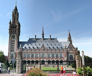
Zorgvliet is a neighbourhood in the Scheveningen district of The Hague, Netherlands. It is named after the estate of the same name, once owned by the poet and writer Jacob Cats,, later by 18th century politician Willem Bentinck van Rhoon and later again becoming the official residence of the Dutch Prime Minister. It has 377 inhabitants and covers an area of 876 hectares (3.38 sq mi). It is bordered by the Laan van Meerdervoort, the Groot Hertoginnelaan, the Stadhouderslaan, the Stadhoudersplantsoen and the Eisenhowerlaan. Zorgvliet is the location of The Hague's "international zone", which is home to the International Criminal Tribunal for the former Yugoslavia, the Organisation for the Prohibition of Chemical Weapons, Europol and the World Forum Convention Center. The Peace Palace, housing the Permanent Court of Arbitration and the International Court of Justice, is also located in Zorgvliet. Moreover, Zorgvliet is the location of the Museum Mesdag, Gemeentemuseum Den Haag and Museon.

Houtwijk is a neighbourhood of The Hague, located in the Loosduinen district, with more than 5,000 homes. Houtwijk mainly contains a lot of new constructions that were built both in and after the 1970s and 1980s. There are also both many owner-occupied and rental properties. While officially a neighbourhood of Loosduinen, some residents consider it its own subdistrict. This is mainly because its name contains wijk which translates to "district".

Kijkduin en Ockenburgh is a Dutch subdistrict of the Loosduinen district in The Hague. The subdistrict is located in the western part of The Hague at the municipal border of Monster. The area is bordered by the North Sea, an imaginary line between beach pole 105 and the De Savornin Lohmanlaan, the Machiel Vrijenhoeklaan, the Duinlaan, the Kijkduinsestraat, the Ockenburghstraat, the Loosduinse Hoofdstraat, the Monsterseweg and the municipal border with Monster. As the name suggests, the subdistrict consists of two neighborhoods Kijkduin and Ockenburgh.
