The Hague Center

Last updated
Centrum
Haagse stadsdeel-centrum.PNG
Location in The Hague
Country Netherlands
Province South Holland
Municipality The Hague
Government
  Alderman Bert van Alphen (GL)
Area
[1]
  Total779.3 ha (1,925.7 acres)
  Land762.0 ha (1,882.9 acres)
Population
 (1 January 2018) [2]
  Total104,658
  Density13,000/km2 (35,000/sq mi)
Time zone UTC+1 (CET)
  Summer (DST) UTC+2 (CEST)

The City Center of The Hague (Dutch : Centrum) is the oldest and, with a population of 104,658 inhabitants (as of 1 January 2018), [2] the second largest of The Hague's eight districts, consisting of nine neighbourhoods. [3] Two railways stations can be found in the city center: Den Haag Centraal and Den Haag Hollands Spoor.

Contents

Subdistricts

The district Centrum of The Hague is divided in the following subdistricts (Dutch:wijken): [4] [5]

Archipelbuurt

Plein 1813 (Square 1813) with a monument commemorating the founding of the Kingdom of the Netherlands, as seen on a photochrom from ca. 1900. Den Haag - Nationaal gedenkteken Plein 1813.jpg
Plein 1813 (Square 1813) with a monument commemorating the founding of the Kingdom of the Netherlands, as seen on a photochrom from ca. 1900.

The neighbourhood Archipelbuurt / Willemspark was largely built at the end of the 19th century. On the south-west border is a Jewish cemetery that dates back to 1694. Later on both the non-denominational and Roman Catholic cemeteries were also situated in this location. The neighbourhood has many wide avenues and streets with large houses, although housing in the smaller streets is more modest. There are even so-called 'hofjeswoningen', an early form of socialised housing. A lot of the large houses nowadays are used as offices, for example at the Nassauplein, the Koninginnegracht and the Laan Copes van Cattenburch. On the southern border of the Archipelbuurt there are newly built offices, the police headquarters and the Nationale Investeringsbank (National Investment Bank).

Oude Centrum

The medieval Binnenhof, meeting place of the Dutch houses of parliament, the city of The Hague originated. Binnenhof1.jpg
The medieval Binnenhof, meeting place of the Dutch houses of parliament, the city of The Hague originated.

The Oude Centrum (Old Center) forms the heart of The Hague, which includes the Binnenhof and Hofvijver, the Noordeinde Palace, the Mauritshuis museum, and the City Hall of The Hague. The history of the old center is reflected in the architectural diversity that can be found in this part of the city center, ranging from 17th century Renaissance to 20th century expressionism.

Schilderswijk

The Schilderswijk is still one of the poorest neighbourhoods of the Netherlands. Unemployment is significant, and many people are dependent on governmental support. In 2006 (the latest available figures), 70% of the inhabitants of the Schilderswijk had a low income, 25% a middle income, and 5% a high income. In 3450 residents in 2007 undertook paid employment or self, the magnitude of the potential workforce (the number of people aged 15–64) was in 2008 22,253. Of all households in the district lived in Schilderswijk in 2007 42% of the poverty line from 16% in The Hague[ citation needed ].

Vaillantlaan: social housing project by architect Jo Coenen Vaill Stortenbekerboog.jpg
Vaillantlaan: social housing project by architect Jo Coenen

More than 90% of the registered residents are of non-Western origin - notably Turkish, Moroccan and Surinamese. Of the housing stock approximately 25% is privately owned, these homes are often rented. The remaining houses are owned by the housing association HaagWonen. Especially in the eastern part of the Schilderswijk (Orange Square and around the station Holland Spoor) some problems have been addressed, so the renewed Orange Square, have built larger homes including houses for sale, for example the new Mirador project, and the prostitution in the Dijksestraat were removed. This street is changed in the Wolterbeek Street.

The migration changed the district not only physically but also socially. The investment by the government to solve the problems of urban renewal in the district not, the unemployment remained high, the neighborhood quickly deteriorated again, crime increased and there was nuisance of drug addicts, vandalism and graffiti. The response from the community was a social community development, welfare and housing associations which were deployed. The approach consisted mainly of amenity programs. Thus, many such residents to activities funded social cohesion in the area to strengthen. Also, many small changes made to the social security and increase the pollution abatement, such as better lighting and more garbage.

Stationsbuurt

Hollands Spoor Station, built in 1891-1893 Den Haag - Station Holland Spoor v1.JPG
Hollands Spoor Station, built in 1891-1893
The impoverished Oranjeplein in the Stationsbuurt, before its renovation. Oranjeplein in 2002.jpg
The impoverished Oranjeplein in the Stationsbuurt, before its renovation.

Many original buildings from the late 19th and early 20th century were demolished and replaced by new buildings in the 1970s and 1980s in the context of an urban renewal that started around 1975. The area between Station and Hollands Spoor Rijswijkseplein, for instance, had been completely renovated. From 2000 on, the district was renovated, this time with more respect for the historic value of buildings. Besides the demolition and replacement of old houses, a lot of houses were renovated instead, an example being the Orange Square, in 2003. Despite all the innovation, a few monumental buildings can be found in the Stationsbuurt, such as the houses of the Huygens Park, Groenewegje, Bierkade, Dunne Bierkade and Oranjeplein, and some monumental houses can still be found at the Stationsweg. At the Van Hogendorpstraat, a "labourer's courtyard" can still be found. Many companies are located in the Stationsbuurt, in particular due to the proximity of public transport. In 1981 a plan was adopted by the municipality that would make sure that the residential function of the neighbourhood would be retained.

Kortenbos

Kortenbos: The (back-) entrance of the City Bank of Loans at the Korte Lombardstraat (Vincent van Gogh, 1882) 1882, Ingang van de Stadsbank van Lening te Den Haag. Vincent van Gogh.jpg
Kortenbos: The (back-) entrance of the City Bank of Loans at the Korte Lombardstraat (Vincent van Gogh, 1882)

The Kortenbos neighbourhood is amongst of the oldest of The Hague, and dates back to the Middle Ages. Most inhabitants of The Hague define Kortenbos as the area between the Jan Hendrikstraat/Torenstraat, Noordwal, Lijnbaan and Prinsegracht. This is the area where the neighborhood association is active. However, the area north of the Torenstraat/Jan Hendirkstraat is also part of the neighbourhood. This is the Hofkwartier district, located around the Molenstraat, Oude Molstraat and Noordeinde.

Kortenbos' main function is living. In earlier days there were a lot of small companies and some larger companies, for example the Zuid Hollandse Bierbrouwerijen (South Holland Brewery) located on the Noordwal. Typically its population used to consist of some of the poorer inhabitants of the city. Only in the area of the Westeinde (West End Street) to the Prinsegracht (Prince Canal) you would find more exclusive residences. The neighbourhood was partly reorganised in the early 1930s, with a second, more intense reorganisation in the 1970s. A lot of old houses and industrial buildings were demolished and replaced with new buildings, mainly socialised housing. The two 'hofjes' in Kortenbos were tidied up; the monumental 'Hofje van Nieuwkoop' and the 'Hofje van Vredebest'. The renovation was officially finished in 1991, although a new project was started immediately after, involving housing on the former location of the bathhouse on the Torenstraat.

As a neighbourhood where a lot of working-class people lived, it was a logical choice for the 1872 Hague Congress, also called the fifth congress of the International Workingmen's Association (IWA), held from 2–7 September. A decisive conflict took place at the meeting in a café annex conference room called "Excelsior" in the korte Lombardstraat, between the champions of the political struggle of the proletariat Karl Marx and Mikhail Bakunin, where Bakunin was to be expelled from the movement. Also a number of incidents would take place between supporters of the IWA on the one hand and anarchists on the other. Perhaps most dramatic was an accident, when on account of too many supporters being cramped up on a balcony of the meeting hall, it collapsed, and a number of people where severely hurt.

Transvaal

Transvaal: Rear side of public housing at 's-Gravenzandelaan (2015) Netherlands, The Hague (Den Haag), 's-Gravenzandelaan, rear side.JPG
Transvaal: Rear side of public housing at 's-Gravenzandelaan (2015)

Transvaal is a multi-ethnic area with 15,472 inhabitants as of 1 January 2013. Starting in the 1990s, many poor houses were demolished to make room for new buildings. This significantly changed the character of the neighbourhood. Transvaal changed from a popular to a multicultural neighbourhood. As of 2013, immigrants make up over 90% of the neighbourhood's population, primarily Moroccan, Turkish, and Surinamese people. [6]

2012Numbers%
Total population15,472100.0
Dutch natives1,2548.1
Western immigrants2,12013.7
Non-Western immigrants12,09878.1
Suriname3,50022.6
Morocco1,91012.3
Turkey4,47028.9
Antilles3122.0
Others1,90612.3
Transvaal: Mosque at Bloemfonteinstraat (2006) Transvaal Bloemfonteinstraat001.jpg
Transvaal: Mosque at Bloemfonteinstraat (2006)

Transvaal is not a wealthy neighborhood; recent figures show that 71% of households have a low income, 24.5% have a middle income, and 4.5% a high income. 32.8% of residents of Transvaal lives of a minimum income, which is twice as high as the city's average. The potential labour force (the population aged 15–64) is 10,875 as of January 2013, but only 2,998 these people in the district earn income or are self-employed. The neighbourhood has about 5,887 homes, owned by the Hague Staedion corporation (50%), Haag Housing (13%), and individuals (37%). The housing is uniform in the Transvaal; there is little variation. Transvaal is one of the most densely populated districts of The Hague. Squares, parks and public green spaces are scarce. The district has high mobility, with 30% of residents moving each year, most of them leaving the Transvaal area. This has a negative impact on social cohesion in the neighbourhood.

Since the 1990s the district has become a local focus area, beginning with demolishing buildings and refurbishing streets. In the beginning there was not much consistency in the plans but a study on housing and living situations in the Transvaal began in 1998 in order to create a coherent plan. Since 2002 a major restructuring has been underway, to be finished in 2015. In that period will be demolished housing corporation 2400, 1250 before coming back which houses 70% 30% sale and rent. Transvaal was always a uniform area with a lot of porch homes, in the future should be more varied housing. A limited number of buildings being renovated, including the former Bathhouse and Juliana Church. There are more demolished than built back, hence the district - who crowded - what with more spacious squares, parks and gardens. An example of recreational space was opened in 2005 at the KempStreet Wijkpark. Moreover, adjacent to the western Transvaal to the Zuiderpark.

In 2007, Transvaal was appointed as one of forty priority neighbourhoods by the Dutch government. Under this program, an action plan was written for the area, describing how residents, community, welfare and corporations want the district to look in ten years. The district is a district with a strong social cohesion, a versatile and provisioning a thriving multicultural shopping wijkeconomie which the heart is, says the plan. In 2007, two projects started to the degradation in the district to counter: Transart Hotel and Transvaal. Both were nominated in 2007 for the New City Price. The prize was won by Transvaal Hotel, this project received €5000,-.

In March 2008, the municipality would promote the shopping street, the Paul Kruger Avenue, an exclusive shopping is Hindu. This is in line with the shops in this street.

Uilebomen

It was at the home at Fluwelen Burgwal 18 in April 1782 that John Adams established the first US embassy and first diplomatic mission in the Netherlands. [7] The home Adams' acquired as the diplomatic mission is gone and replaced by a high rise residential complex.

Voorhout

Escher Museum at Lange Voorhout (2005) Escher museum-edit.jpg
Escher Museum at Lange Voorhout (2005)

Zeeheldenkwartier

Zeeheldenkwartier: Van Speijkstraat (2004) Van Speijkstraat DH.JPG
Zeeheldenkwartier: Van Speijkstraat (2004)

The Zeeheldenkwartier is the neighbourhood west of the old center, further divided into the Zeeheldenbuurt, where many wealthy officials live, and the Dichtersbuurt closer to the old center, with predominantly smaller houses than in the Zeeheldenbuurt. Much of the neighbourhood was built in the 19th century, when the area within the canal ring of The Hague didn't have the capacity to meet the significant urbanisation caused by the Industrial Revolution.

See also

Related Research Articles

<span class="mw-page-title-main">The Hague</span> City and municipality in South Holland, Netherlands

The Hague is a city and municipality of the Netherlands, situated on the west coast facing the North Sea. The Hague is the capital of the province of South Holland. The Hague is the country's administrative centre and its seat of government, and while the official capital of the Netherlands is Amsterdam, The Hague has been described as the country's de facto capital.

<span class="mw-page-title-main">Scheveningen</span> District in South Holland, Netherlands

Scheveningen is one of the eight districts of The Hague, Netherlands, as well as a subdistrict (wijk) of that city. Scheveningen is a modern seaside resort with a long, sandy beach, an esplanade, a pier, and a lighthouse. The beach is popular for water sports such as windsurfing and kiteboarding. The harbour is used for both fishing and tourism.

<span class="mw-page-title-main">Zoetermeer</span> City and municipality in South Holland, Netherlands

Zoetermeer is a city in the Western Netherlands, in the province of South Holland. The municipality covers an area of 37.05 km2 (14.31 sq mi) of which 2.60 km2 (1.00 sq mi) is water. A small village until the late 1960s, it had 6,392 inhabitants in 1950. By 2013 this had grown to 123,328, making it the third largest population centre in the province of South Holland, after Rotterdam, The Hague and Leiden. While now a city in its own right, Zoetermeer started out as a suburb of The Hague and is still a part of the Greater The Hague urban area.

<span class="mw-page-title-main">Ommoord</span>

Ommoord is a neighbourhood in the former borough Prins Alexander, part of the municipality of Rotterdam, South Holland, the Netherlands. Ommoord is surrounded by the neighbourhoods Zevenkamp, Het Lage Land and Terbregge. It has around 25.000 inhabitants across 12.500 households. Ommoord shares postal codes 3068 and 3069 with Zevenkamp.

<span class="mw-page-title-main">Jordaan</span> Neighbourhood of Amsterdam in North Holland, Netherlands

The Jordaan is a neighbourhood of the city of Amsterdam, Netherlands. It is part of the borough of Amsterdam-Centrum. The area is bordered by the Singelgracht canal and the neighbourhood of Frederik Hendrikbuurt to the west; the Prinsengracht to the east; the Brouwersgracht to the north and the Leidsegracht to the south. The former canal Rozengracht is the main traffic artery through the neighbourhood.

<span class="mw-page-title-main">Den Haag Centraal railway station</span> Railway station in The Hague

Den Haag Centraal is the largest railway station in the city of The Hague in South Holland, Netherlands, and with twelve tracks, the largest terminal station in the Netherlands. The railway station opened in 1973, adjacent to its predecessor: Den Haag Staatsspoor, which was subsequently demolished. It is the western terminus of the Gouda–Den Haag railway.

<span class="mw-page-title-main">Districts of The Hague</span>

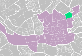
The city of The Hague, Netherlands, consists of eight districts, similar to boroughs. Each district is divided into subdistricts (wijken). Each of these stadsdelen has its own district office (stadsdeelkantoor), where most of the local government activity is organised. These stadsdeelkantoren make many aspects of local government more accessible to residents. The current division of The Hague into individual stadsdelen was created in 1988 by the main city government. This division of The Hague into wijken (subdistricts) and buurten (neighbourhoods) deviates from the 1953 divisions that had been known to many residents.

<span class="mw-page-title-main">Benoordenhout</span> Place in South Holland, Netherlands

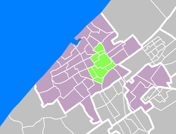
Benoordenhout is a neighbourhood in the Haagse Hout district of The Hague. In addition to Benoordenhout, Haagse Hout consists of the Bezuidenhout, Mariahoeve en Marlot, and Haagse Bos neighbourhoods.

<span class="mw-page-title-main">Loosduinen</span> District of The Hague in South Holland, Netherlands

Loosduinen is a former village in the Netherlands that was a municipality unto itself until 1923, when it was annexed by The Hague and subsequently became a district of the city.

<span class="mw-page-title-main">Den Haag HS railway station</span> Railway station in The Hague, Netherlands

Den Haag HS, an abbreviation of the original name Den Haag Hollands Spoor, is the oldest train station in The Hague, South Holland, Netherlands, located on the Amsterdam–Haarlem–Rotterdam railway. It is the second main station in The Hague and, unlike The Hague Central Station, it is not a terminus station. The name of the station is derived from the former Hollandsche IJzeren Spoorweg-Maatschappij (HIJSM) which was the first Dutch railway company.

<span class="mw-page-title-main">Spoorwijk</span>

Spoorwijk is a residential neighbourhood in the Laak district of The Hague, Netherlands. Its name, literally rail neighbourhood or track neighbourhood, originated from the fact that the area borders the Amsterdam–Haarlem–Rotterdam railway on the west. The neighbourhood has 4,161 inhabitants and covers an area of 33,3 ha.

<span class="mw-page-title-main">Bombing of the Bezuidenhout</span> 1945 British military error during WWII

The bombing of the Bezuidenhout took place on 3 March 1945, when the Royal Air Force mistakenly bombed the Bezuidenhout neighbourhood in the Dutch city of The Hague resulting in the death of 532 citizens.

<span class="mw-page-title-main">Laak, The Hague</span>

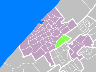
Laak is district of The Hague, Netherlands. With a population of 40,222 and an area of 4.3 square kilometres (1.7 sq mi), it is the smallest and least populous of the city's eight districts. The district is officially divided into three neighbourhoods: Laakkwartier, Spoorwijk and Binckhorst. The Hague University of Applied Sciences can be found in Laak.

<span class="mw-page-title-main">Archipelbuurt</span>

The Archipelbuurt is a neighbourhood in the Centrum district of The Hague, Netherlands. It has 5,764 inhabitants and covers an area of 87.1 hectares (0.336 sq mi). Built primarily between 1860 and 1890, the neighbourhood is known for its Neo-Renaissance architecture and wide avenues and streets. Important streets in the Archipelbuurt include the Javastraat, the Surinamestraat, the Scheveningseweg, the Nassauplein and the Burgemeester De Monchyplein. A Jewish graveyard, a chapel and a former city hall of The Hague can be found in the neighbourhood. The Dutch novelist and poet Louis Couperus resided in Javastraat 17. Today, this is the Louis Couperus Museum.

<span class="mw-page-title-main">Zeeheldenkwartier</span>

The Zeeheldenkwartier is a neighbourhood in the Centrum district of The Hague, Netherlands. It has 11,205 inhabitants and covers an area of 81.3 hectares (0.314 sq mi). It is bordered by the Carnegielaan, the Zeestraat, the Hoge Wal and the Prinsessewal to the north-east, the Veenkade to the south, the Waldeck Pyrmontkade to the south-west and the Laan van Meerdervoort to the Carnegielaan to the north. Built between 1870 and 1890, the style of the buildings differs between larger houses for important officials near the Willemspark and the Laan van Meerdervoort, and predominantly smaller houses nearer to the city centre. It has also the most Coffeeshops in town. And it has from Albert Heijn the biggest supermarket in town called “Albert Heijn XL”.

<span class="mw-page-title-main">Willemspark</span>

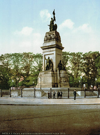
The Willemspark is a neighbourhood in the Centrum district of The Hague, Netherlands. It has 1,393 inhabitants and covers an area of 34.6 hectares (0.134 sq mi). It is bordered by the Zeestraat to the south-east, the Scheveningseveer, the Mauritskade and the Dr. Kuyperstraat to the south-east, the Prinsessegracht to the north-east and the Javastraat to the north-west. The park was originally property of king William II, but he sold the area to the municipality of The Hague in 1855, after which it became a villa park. Iconic to the neighbourhood are the Alexanderstraat and the Sophialaan that intersect on Plein 1813. This square is marked by a monument commemorating the defeat of Napoleon and the establishment of the Sovereign Principality of the United Netherlands.

<span class="mw-page-title-main">Zorgvliet</span>

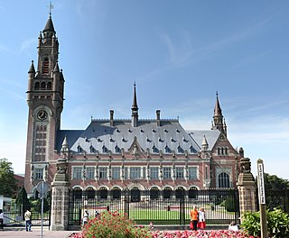
Zorgvliet is a neighbourhood in the Scheveningen district of The Hague, Netherlands. It is named after the estate of the same name, once owned by the poet and writer Jacob Cats,, later by 18th century politician Willem Bentinck van Rhoon and later again becoming the official residence of the Dutch Prime Minister. It has 377 inhabitants and covers an area of 876 hectares (3.38 sq mi). It is bordered by the Laan van Meerdervoort, the Groot Hertoginnelaan, the Stadhouderslaan, the Stadhoudersplantsoen and the Eisenhowerlaan. Zorgvliet is the location of The Hague's "international zone", which is home to the International Criminal Tribunal for the former Yugoslavia, the Organisation for the Prohibition of Chemical Weapons, Europol and the World Forum Convention Center. The Peace Palace, housing the Permanent Court of Arbitration and the International Court of Justice, is also located in Zorgvliet. Moreover, Zorgvliet is the location of the Museum Mesdag, Gemeentemuseum Den Haag and Museon.

<span class="mw-page-title-main">Forepark</span> Business park in The Hague, Netherlands

Forepark is a business park in The Hague, Netherlands, east of the Prins Clausplein highway interchange. It was developed in the 1990s, together with the nearby residential neighbourhood Leidschenveen. Originally part of the municipality of Leidschendam, it was annexed by The Hague in 2002 and now falls under the district of Leidschenveen-Ypenburg. Since 2007, Forepark is home to Cars Jeans Stadion, the home stadium of ADO Den Haag. Since the construction of the RandstadRail network, the business park is connected to the metro line between Rotterdam and the city centre of The Hague via Forepark Station.

<span class="mw-page-title-main">Houtwijk</span> Neighbourhood of The Hague in South Holland, Netherlands

Houtwijk is a neighbourhood of The Hague, located in the Loosduinen district, with more than 5,000 homes. Houtwijk mainly contains a lot of new constructions that were built both in and after the 1970s and 1980s. There are also both many owner-occupied and rental properties. While officially a neighbourhood of Loosduinen, some residents consider it its own subdistrict. This is mainly because its name contains wijk which translates to "district".

<span class="mw-page-title-main">Jokinen Plan</span> Traffic plan for Amsterdam and The Hague

The Jokinen Plan comprises two reports, drawn up by the American traffic expert David A. Jokinen, on the urban planning of two Dutch cities: for The Hague in 1962, and for Amsterdam in 1967, both set out in a brochure.

References

  1. "totale 2018". Den Haag in Cijfers (in Dutch). Retrieved 4 December 2018.
  2. 1 2 "Aantal inwoners per 1-1 - Stadsdelen". Den Haag in Cijfers (in Dutch). Retrieved 4 December 2018.
  3. "Description of the city center" (PDF) (in Dutch). Municipality of The Hague. October 2002. p. 68. Archived from the original (PDF) on 29 May 2004. Retrieved 2006-06-20.
  4. Municipality The Hague (2021). "Samenvatting Wijkscans & Prioritaire thema's per stadsdeel". denhaag.nl.
  5. "Wijken". ckan.dataplatform.nl. Retrieved 2023-05-19.
  6. "Home - Den Haag in Cijfers". denhaag.incijfers.nl.
  7. "Dutch American Friendship Day / Heritage Day". December 30, 2006. Archived from the original on 2006-12-30.

52°04′14″N4°18′46″E / 52.0706°N 4.3129°E / 52.0706; 4.3129