Related Research Articles

The San Juan Islands are an archipelago in the Pacific Northwest of the United States between the U.S. state of Washington and Vancouver Island, British Columbia, Canada. The San Juan Islands are part of Washington state, and form the core of San Juan County.
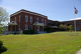
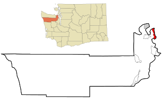
San Juan County is a county located in the Salish Sea in the far northwestern corner of the U.S. state of Washington. As of the 2020 census, its population was 17,788. The county seat and only incorporated city is Friday Harbor, located on San Juan Island. The county was formed on October 31, 1873, from Whatcom County and is named for the San Juan Islands, which are in turn named for Juan Vicente de Güemes, 2nd Count of Revillagigedo, the Viceroy of New Spain.

Fairbanks Township is a civil township of Delta County in the U.S. state of Michigan. As of the 2010 census, the township population was 281, down from 321 at the 2000 census.

Gilgo-Oak Beach-Captree, frequently just called Oak Beach, was a census-designated place (CDP) in Suffolk County, New York within the Town of Babylon. The population was 333 at the 2000 census.

Huron is a town in Wayne County, New York, United States. The population was 2,118 at the 2010 census. The town is named after the Huron Indians.

Freeland is an unincorporated community and census-designated place (CDP) on Whidbey Island in Island County, Washington, United States. At the time of the 2010 census the population was 7,812. The town received its name based on its origins as a socialist commune in the early 1900s: in the eyes of its founders, the land of the town was literally to be free for all people. Some of the first settlers were veterans of a prior experiment in socialism, the nearby Equality Colony.
Marrowstone is a census-designated place (CDP) in Jefferson County, Washington, United States. The population was 844 at the 2010 census. All Marrowstone addresses are in Nordland, Washington, and the ZIP code for Marrowstone Island is 98358.

Port Hadlock-Irondale is a census-designated place (CDP) in Jefferson County, Washington, United States. The population was 3,580 at the 2010 census.
Bayview is an unincorporated community centered at the intersection of State Route 525 and Bayview Road on Whidbey Island in Island County, Washington, United States.

Orcas Island is the largest of the San Juan Islands of the Pacific Northwest, which are in the northwestern corner of San Juan County, Washington.

Camp Orkila is on the northwest shoulder of Orcas Island in the San Juan Islands of Washington, overlooking Presidents Channel, and the Canadian Gulf Islands. It has been in operation since 1906.
Silver Lake, sometimes Silverlake, is an unincorporated community in Cowlitz County, Washington, in the southwestern portion of the state. Silver Lake is located 6 miles (9.7 km) east of Castle Rock along Washington State Route 504, which is also known as the Spirit Lake Memorial Highway. The area considered Silverlake is about 6 miles (10 km) east of Interstate 5 (I-5) and is approximately 50 miles (80 km) from Portland, Oregon, to the south and Seattle about 110 miles (180 km) to the north. The closest cities to the subject property are Castle Rock, six miles (10 km) to the west, and Toutle, four miles (6 km) east.

Padilla Bay is a bay located in the U.S. state of Washington, between the San Juan Islands and the mainland. Fidalgo Island and Guemes Island lie to the west of Padilla Bay. Guemes Channel, between the islands, connects Padilla Bay to Rosario Strait. Samish Island lies to the north of Padilla Bay, beyond which is Samish Bay and Bellingham Bay.
Crane Island is one of the San Juan Islands in San Juan County, Washington, United States. It lies just off the southwestern shore of Orcas Island, between it and the northwest corner of Shaw Island. Crane Island has a land area of 0.956 km². The 2000 census reported a population of 20 permanent residents.

The Charles W. Ward Reservation is a 704-acre (285 ha) open space reserve located in Andover and North Andover, Massachusetts, 20 miles (32 km) north of Boston. The reserve, managed by the land conservation non-profit organization The Trustees of Reservations, is notable for its open drumlin hilltops and vistas encompassing Boston and Salem. The Ward Reservation offers 13 miles (21 km) of trails and former woods roads available for hiking, horseback riding, mountain biking, and cross country skiing; it is also a link in the 200-mile (320 km) Bay Circuit Trail system.

Saratoga Passage lies in Puget Sound between Whidbey Island and Camano Island.
Skull Island is the name of two small islands in the San Juan Archipelago in the U.S. state of Washington. The northernmost Skull Island is located off the coast of Orcas Island in Massacre Bay, the most northern extension of the island's West Sound. It is identified as 3.2-acre (1.3 ha) Skull Island State Park Property by the Washington State Parks and Recreation Commission. It was named for holding skulls and bones of a band of Lummi who were killed by raiding Haida in 1858. Since 2013, it has been part of the San Juan Islands National Monument.

Matia Island is an island in the San Juan Islands of the U.S. state of Washington. The island's entire 145 acres (59 ha) comes under the protection of the U.S. Fish and Wildlife Service and is cooperatively managed by the Washington State Parks and Recreation Commission as Matia Island Marine State Park. Matia Island is a National Wildlife Refuge, part of the San Juan Islands National Wildlife Refuge. A 2-acre (0.81 ha) camping area around Rolfe Cove is managed as a State Marine Park by the Washington State Parks and Recreation Commission under an agreement dating back to 1959. Pets, wood collecting, and campfires are not allowed on the island. Except for the Wilderness Loop Trail and the campground, all areas above the high tide line are closed to the public.

The Interurban Trail is a rail trail in Whatcom County, Washington. It runs 6.6 miles (10.6 km) between Fairhaven and Larrabee State Park (48°38′52″N122°29′12″W) in the Bellingham area. Popular with hikers and bicycles, the trail runs parallel to Chuckanut Drive through the Chuckanut Mountains. The trail follows the shoreline of the Salish Sea and Puget Sound, with ample views of Bellingham Bay, the Lummi Peninsula, Portage Island, Lummi Island, Chuckanut Bay and the distant San Juan Islands.
References
- ↑ U.S. Geological Survey Geographic Names Information System: Doe Bay, Washington
- ↑ Pfeuffer, Charyn. "Up in the Air (January 2017)". Sunset. Sunset Publishing Corporation.
