Related Research Articles
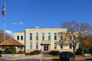
Ozark County is a county in the southern portion of the U.S. state of Missouri. As of the 2020 census, the population was 8,553. The largest city and county seat is Gainesville. The county was organized as Ozark County, named after the Ozark Mountains, on January 29, 1841. It was renamed Decatur County, after Commodore Stephen Decatur, from 1843 to 1845, after which the name Ozark County was restored.

Miller County is a county located in the U.S. state of Missouri. As of the 2020 United States census, the population was 24,722. Its county seat is Tuscumbia. The county was organized February 6, 1837 and named for John Miller, former U.S. Representative and Governor of Missouri.
Roach is an unincorporated community in southern Camden County, Missouri, United States. It is located north of U.S. Route 54 on Missouri Route AA, approximately five miles west of Camdenton and 2.5 miles west of the Niangua River arm of the Lake of the Ozarks. The ZIP Code for Roach is 65787.

Pottersville is an unincorporated hamlet in Howell County, Missouri, United States. It is located approximately ten miles west of West Plains. Besides a few homes, only a post office and fire station are located there. The ZIP Code for Pottersville is 65790.
Almartha is an unincorporated community in northern Ozark County, Missouri, United States. It is located approximately thirteen miles north of Gainesville and four miles southeast of Wasola on Route 95. The village is located in a valley on a tributary of Spring Creek. Several homes are located there. The old mill and current fish hatchery of Rockbridge lies downstream on Spring Creek, about six miles to the east.
Thornfield is an unincorporated community in Ozark County, Missouri, United States. It is located 15 miles (24 km) northwest of Gainesville, on Route 95 at the Little North Fork of the White River on the edge of the Mark Twain National Forest between Wasola to the northeast and Longrun to the southwest. Hammond, the site of the historic Hammond Mill, lies on the Little North Fork 2.5 miles (4.0 km) southeast of Thornfield. Thornfield has a post office with ZIP code 65762.

Howards Ridge is an unincorporated community in southeastern Ozark County in the southern Missouri Ozarks, United States. It is located seven miles southeast of Gainesville and 2.15 miles north of the Arkansas border, at the intersection of Ozark County routes J and T. The community is at an elevation of 880 feet and lies two and a half miles west of Norfork Lake.

Lesterville is an unincorporated community in southeast Missouri, United States. It is located in Reynolds County on Routes 21, 49, and 72 near the Black River. The ZIP Code for Lesterville is 63654.
Foil is an unincorporated community in northern Ozark County, Missouri, United States. It is located approximately sixteen miles south of Ava on county roads 953 and 955. Wasola is about four miles northeast on Missouri Route 5 and Thornfield approximately three miles southwest on Missouri Route JJ. The community is on the banks of Little Creek, a tributary of Little North Fork White River.
Elkhead is an unincorporated community in eastern Christian County, Missouri, United States. It is located on Route 14, approximately sixteen miles east of Ozark. Elkhead formerly had a post office with a ZIP code 65643, but mail is now served by the post office in Sparta.

Laquey is an unincorporated community in Pulaski County, Missouri, United States. It has Zip Code: 65534 and Area Code: 573.
Falcon is an unincorporated community in eastern Laclede County, Missouri, United States. It is approximately sixteen miles east of Lebanon on Route 32. The Gasconade River lies just east of the community, which is within the Mark Twain National Forest. The community consists of a post office and two houses.

Knob Lick is an unincorporated community in southern Saint Francois County, Missouri, United States. It is located on Missouri Route DD, just east of U.S. Route 67, approximately eight miles south of Farmington.
Rocky Mount is an unincorporated community in eastern Morgan County, Missouri, United States. It is located six miles southwest of Eldon, near the Lake of the Ozarks. The ZIP Code for Rocky Mount is 65072.
Althea is an extinct town in eastern Ozark County, in the Ozarks of southern Missouri, United States. The GNIS classifies it as a populated place. The location is on the North Fork River at the crossing of Missouri Route H, at an elevation of 623 feet. It is approximately five miles northeast of Tecumseh.
Fay is an unincorporated community in southeastern Ozark County, in the Ozarks of south-central Missouri, United States. The community is located along Missouri Route J, approximately 2.5 miles south of U.S. Route 160. The Fay Cemetery lies just west of Route J and north of the Lick Creek - Sweeten Creek junction.
Locust is an unincorporated community in Ozark County, Missouri, United States. The community is located on South Fork Bratten Spring Creek, approximately one mile east of a northeast arm of Bull Shoals Lake. Access is via a county road south from U.S. Route 160, southwest of Gainesville.
Oak Mound is an unincorporated community in eastern Ozark County, in the Ozarks of south-central Missouri, United States. The community was located on Bond Ridge and the Oak Mound Cemetery lies adjacent to the south side of Missouri Route KK. The North Fork of the White River lies just over one mile west of the site.
Pondfork is an unincorporated community in northwest Ozark County, Missouri, United States. Pondfork lies on the Hay Hollow tributary to Pond Fork Creek, which lies to the west. The community is approximately three miles west-southwest of Thornfield. Access is via Missouri Route D, from Missouri Route 95 to the southeast. Pondfork lies within the Mark Twain National Forest.
Prestonia is an unincorporated community in Ozark County, Missouri, United States. The Prestonia site lies on a ridge above East Pidgeon Creek and is southwest of Howards Ridge. The Missouri-Arkansas border is approximately one mile to the south and Norfork Lake is about four miles to the east. Access is from Missouri Route J via county road J529.
References
- ↑ U.S. Geological Survey Geographic Names Information System: Dora, Missouri
- ↑ "Dora ZIP Code". zipdatamaps.com. 2022. Retrieved November 11, 2022.
- ↑ "Post Offices". Jim Forte Postal History. Archived from the original on 4 March 2016. Retrieved 27 November 2016.
- ↑ "Ozark County Place Names, 1928–1945". The State Historical Society of Missouri. Archived from the original on June 24, 2016. Retrieved November 27, 2016.
- ↑ "Homepage". Dora R-III School District. Retrieved 27 November 2016.
Municipalities and communities of Ozark County, Missouri, United States | ||
|---|---|---|
| City |  | |
| Villages | ||
| Townships | ||
| CDPs | ||
| Other communities | ||
| Ghost towns | ||
36°46′37″N92°13′03″W / 36.7770036°N 92.2173801°W
| Authority control: Geographic |
|---|
| | This Ozark County, Missouri state location article is a stub. You can help Wikipedia by expanding it. |