Dugway, Utah

Last updated

Dugway, Utah
CDP
Tooele County Utah incorporated and unincorporated areas Dugway highlighted.svg
Location in Tooele County and the state of Utah
Map of USA UT.svg
Location of Utah in the United States
Coordinates: 40°13′52″N112°45′5″W / 40.23111°N 112.75139°W / 40.23111; -112.75139
Country United States
State Utah
County Tooele
Established1942
Area
  Total5.2 sq mi (13.5 km2)
  Land5.2 sq mi (13.5 km2)
  Water0.0 sq mi (0.0 km2)
Population
 (2000)
  Total2,016
  Density387.4/sq mi (149.6/km2)
Time zone UTC-7 (Mountain (MST))
  Summer (DST) UTC-6 (MDT)
ZIP code
84022
Area code 435
FIPS code 49-20450 [1]

Dugway is a census-designated place (CDP) in southeastern Tooele County, Utah, United States. The population was 2,016, at the 2000 census, a modest increase over the 1990 figure of 1,761. The town is located inside the United States Army's large weapons testing facility, Dugway Proving Ground, making it a closed city, as the only roads leading to the town pass through military checkpoints at the boundaries of the base. Non-resident civilians must request advance authorization to enter the town. [2] [3] The housing area designated for military and civilian personnel is referred to as "English Village."

Contents

The name "Dugway" comes from a technique to dig a trench along a hillside to keep a wagon from tipping. [4]

Geography

According to the United States Census Bureau, the CDP has a total area of 5.2 square miles (13.5 km2), all land.

Climate

According to the Köppen Climate Classification system, Dugway has a semi-arid climate, abbreviated "BSk" on climate maps. [5]

Demographics

Historical population
CensusPop.Note
1970 2,357
1980 1,646−30.2%
1990 1,7617.0%
2000 2,01614.5%
2010 795−60.6%
2020 342−57.0%
source: [6]

As of the census [1] of 2000, there were 2,016 people, 343 households, and 263 families residing in the CDP. The population density was 387.4 people per square mile (149.7/km2). There were 572 housing units at an average density of 109.9/sq mi (42.5/km2). The racial makeup of the CDP was 63.10% White, 15.03% African American, 8.43% Native American, 2.83% Asian, 0.50% Pacific Islander, 1.88% from other races, and 8.23% from two or more races. Hispanic or Latino of any race were 5.75% of the population.

There were 343 households, out of which 51.0% had children under the age of 18 living with them, 66.5% were married couples living together, 6.1% had a female householder with no husband present, and 23.3% were non-families. 21.9% of all households were made up of individuals, and 0.9% had someone living alone who was 65 years of age or older. The average household size was 3.01 and the average family size was 3.59.

In the CDP, the population was spread out, with 34.4% under the age of 18, 33.4% from 18 to 24, 21.6% from 25 to 44, 10.1% from 45 to 64, and 0.5% who were 65 years of age or older. The median age was 20 years. For every 100 females, there were 47.0 males. For every 100 females age 18 and over, there were 48.5 males.

The median income for a household in the CDP was $49,306, and the median income for a family was $53,148. Males had a median income of $40,565 versus $17,695 for females. The per capita income for the CDP was $11,023. About 5.4% of families and 10.0% of the population were below the poverty line, including 15.7% of those under age 18 and none of those age 65 or over.

Education

All parts of Tooele County are in the Tooele School District. [7] Dugway Schools is the local K-12 school.

See also

Related Research Articles

<span class="mw-page-title-main">Pleasant Grove, Ohio</span> CDP in Ohio, United States

Pleasant Grove is a census-designated place (CDP) in Muskingum County, Ohio, United States. The population was 1,726 at the 2020 census.

<span class="mw-page-title-main">Riverside, Utah</span> CDP in Utah, United States

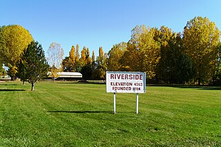
Riverside is a census-designated place (CDP) in Box Elder County, Utah, United States. The population was 760 at the 2010 census.

<span class="mw-page-title-main">South Willard, Utah</span> CDP in Utah, United States

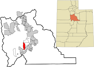
South Willard is a census-designated place (CDP) in Box Elder County, Utah, United States. The population was 1,571 at the 2010 census.

<span class="mw-page-title-main">Cache, Utah</span> CDP in Utah, United States

Cache Junction is a census-designated place (CDP) in Cache County, Utah, United States. The population was 38 at the 2010 census. It is included in the Logan, Utah-Idaho (partial) Metropolitan Statistical Area.

<span class="mw-page-title-main">Cove, Utah</span> Census-designated place in Utah, United States

Cove is a census-designated place (CDP) in Cache County, Utah, United States. The population was 460 at the 2010 census. It is included in the Logan, Utah-Idaho Metropolitan Statistical Area.

<span class="mw-page-title-main">Neola, Utah</span> Census-designated place in Utah, United States

Neola is a census-designated place (CDP) in Duchesne County, Utah, United States. The population was 461 at the 2010 census. Neola was established in 1912.

<span class="mw-page-title-main">Halchita, Utah</span> CDP in Utah, United States

Halchita is a census-designated place (CDP) in San Juan County, Utah, United States. The population was 270 at the 2000 census.

<span class="mw-page-title-main">La Sal, Utah</span> CDP in Utah, United States

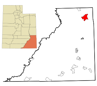
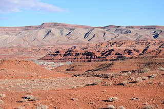
La Sal is a census-designated place (CDP) in northeastern San Juan County, Utah, United States. The population was 339 at the 2000 census. The name comes from the La Sal Mountains which means in Spanish "The Salt". The area is known for its uranium resources.

<span class="mw-page-title-main">Montezuma Creek, Utah</span> Census-designated place in Utah, United States

Montezuma Creek is a census-designated place (CDP) in San Juan County, Utah, United States. The population was 335 at the 2010 census, a decrease from the 2000 figure of 507.

<span class="mw-page-title-main">Tselakai Dezza, Utah</span> CDP in Utah, United States

Tselakai Dezza is a census-designated place (CDP) in San Juan County, Utah, United States. The population was 103 at the 2000 census.

<span class="mw-page-title-main">Woodland, Utah</span> CDP in Utah, United States

Woodland is a census-designated place (CDP) in Summit County, Utah, United States. The population was 335 at the 2000 census.

<span class="mw-page-title-main">Erda, Utah</span> City in Utah, United States

Erda is a city in Tooele County, Utah, United States. The population was 4,642 at the 2010 census, a significant increase from the 2000 figure of 2,473. Erda was previously a Census Designated Place (CDP) and a township but officially received its incorporation certificate in January 2022.

<span class="mw-page-title-main">Ophir, Utah</span> CDP in Utah, United States

Ophir is a census-designated place in Tooele County, Utah, United States. It is part of the Salt Lake City, Utah Metropolitan Statistical Area. The population was 23 at the 2000 census, a decrease of two from the 1990 figure of 25.

<span class="mw-page-title-main">Stansbury Park, Utah</span> CDP and Township in Utah, United States

Stansbury Park is a census-designated place (CDP) in Tooele County, Utah, United States. As of the 2020 United States Census, the population was 9,851, up from the 2010 figure of 5,145.

<span class="mw-page-title-main">Randlett, Utah</span> CDP in Utah, United States

Randlett is a census-designated place (CDP) in west-central Uintah County, Utah, United States. In the 2000 census its population was 224, a 21% decrease from the 1990 figure of 283.

<span class="mw-page-title-main">Elberta, Utah</span> CDP in Utah, United States

Elberta is a census-designated place (CDP) in Utah County, Utah, United States. It is part of the Provo–Orem Metropolitan Statistical Area. The population was 256 at the 2010 census. It was founded as Mt. Nebo. After the water failed in 1901, most of the early settlers moved away. It was purchased by Matthew B. Whitney, a native of New York, on November 7, 1907, and he renamed it "Elberta" after the peach cultivar.

<span class="mw-page-title-main">Lake Shore, Utah</span> CDP in Utah, United States

Lake Shore is a census-designated place (CDP) in Utah County, Utah, United States. It is part of the Provo–Orem Metropolitan Statistical Area. The population was 817 at the 2010 census.

<span class="mw-page-title-main">Palmyra, Utah</span> CDP in Utah, United States

Palmyra is a census-designated place (CDP) in Utah County, Utah, United States. It is part of the Provo–Orem Metropolitan Statistical Area. The population was 491 at the 2010 census. Palmyra is located directly west of Springville and northwest of Spanish Fork.

<span class="mw-page-title-main">Spring Lake, Utah</span> CDP in Utah, United States

Spring Lake is a census-designated place (CDP) in southern Utah County, Utah, United States. It is part of the Provo–Orem Metropolitan Statistical Area. The population was 458 at the 2010 census. It is an unincorporated part of Utah County, located just south of Payson and north of Santaquin.

<span class="mw-page-title-main">West Mountain, Utah</span> CDP in Utah, United States

West Mountain is a census-designated place (CDP) in Utah County, Utah, United States. It is part of the Provo–Orem Metropolitan Statistical Area. As of the 2010 census, the CDP population was 1,186. The town is at the base of West Mountain and bears its name.

References

  1. 1 2 "U.S. Census website". United States Census Bureau . Retrieved January 31, 2008.
  2. "Tighter Security Checks for Visitors". Dugway Proving Ground/United States Army. March 2, 2016. Archived from the original on November 12, 2017. Retrieved November 10, 2017.
  3. "DPG Visitors Guide" (PDF). United States Army, Dugway Proving Ground. p. 9. Archived from the original (pdf) on November 12, 2017. Retrieved November 10, 2017.
  4. Van Cott, J. W., 1990, Utah Place Names, ISBN   0-87480-345-4
  5. Climate Summary for Dugway, Utah
  6. "CENSUS OF POPULATION AND HOUSING (1790-2000)". U.S. Census Bureau . Retrieved July 31, 2010.
  7. "2020 CENSUS - SCHOOL DISTRICT REFERENCE MAP: Tooele County, UT" (PDF). U.S. Census Bureau . Retrieved January 16, 2023. - Text list

Commons-logo.svg Media related to Dugway, Utah at Wikimedia Commons