Rush Valley, Utah

Last updated

Rush Valley, Utah
Tooele County Utah incorporated and unincorporated areas Rush Valley highlighted.svg
Location in Tooele County and the state of Utah
Map of USA UT.svg
Location of Utah in the United States
Coordinates: 40°21′33″N112°27′17″W / 40.35917°N 112.45472°W / 40.35917; -112.45472 Coordinates: 40°21′33″N112°27′17″W / 40.35917°N 112.45472°W / 40.35917; -112.45472
Country United States
State Utah
County Tooele
Settled1856
Incorporated (Onaqui)1934
Incorporated (Rush Valley)February 22, 1972
Named for Rush Lake
Area
[1]
  Total18.08 sq mi (46.83 km2)
  Land18.08 sq mi (46.83 km2)
  Water0.00 sq mi (0.00 km2)
Elevation
5,043 ft (1,537 m)
Population
 (2010)
  Total447
  Estimate 
(2019) [2]
494
  Density27.32/sq mi (10.55/km2)
Time zone UTC-7 (Mountain (MST))
  Summer (DST) UTC-6 (MDT)
ZIP code
84069
Area code(s) 435
FIPS code 49-65240 [3]
GNIS feature ID1699809 [4]
Website www.rushvalleytown.com

Rush Valley is a town in Tooele County, Utah, United States, located in the northwest of Rush Valley. It is part of the Salt Lake City, Utah Metropolitan Statistical Area. The population was 447 at the 2010 census, [5] with an estimate population of 494 in 2019.

Contents

Geography

According to the United States Census Bureau, the town has a total area of 18.3 square miles (47.5 km2), all land.

Climate

According to the Köppen Climate Classification system, Rush Valley has a semi-arid climate, abbreviated "BSk" on climate maps. [6]

History

This area was first settled beginning in 1856. In 1934, a large area of some 33 square miles (85 km2), comprising the settlements of Clover, St. John, and Vernon, was incorporated into a town called Onaqui. The incorporation was essentially a bureaucratic tactic to secure federal aid for development of municipal infrastructure, including from the Rural Electrification Administration. When the people of Vernon were granted a petition to incorporate separately on February 22, 1972, the remaining town was renamed Rush Valley.

Demographics

Historical population
CensusPop.
1940 374
1950 333−11.0%
1960 51153.5%
1970 5415.9%
1980 356−34.2%
1990 339−4.8%
2000 45333.6%
2010 447−1.3%
2019 (est.)494 [2] 10.5%
U.S. Decennial Census [7] [8] [9] [10]

As of the census [3] of 2000, there were 453 people, 149 households, and 123 families residing in the town. The population density was 24.7 people per square mile (9.5/km2). There were 169 housing units at an average density of 9.2 per square mile (3.6/km2). The racial makeup of the town was 98.01% White, 0.22% Native American, 0.22% Pacific Islander, 0.66% from other races, and 0.88% from two or more races. Hispanic or Latino of any race were 1.10% of the population.

There were 149 households, out of which 34.9% had children under the age of 18 living with them, 71.8% were married couples living together, 7.4% had a female householder with no husband present, and 16.8% were non-families. 12.8% of all households were made up of individuals, and 4.7% had someone living alone who was 65 years of age or older. The average household size was 3.04 and the average family size was 3.34.

In the town, the population was spread out, with 26.9% under the age of 18, 10.8% from 18 to 24, 24.5% from 25 to 44, 24.9% from 45 to 64, and 12.8% who were 65 years of age or older. The median age was 38 years. For every 100 females, there were 102.2 males. For every 100 females age 18 and over, there were 106.9 males.

The median income for a household in the town was $46,875, and the median income for a family was $48,036. Males had a median income of $41,136 versus $22,813 for females. The per capita income for the town was $14,661. About 7.1% of families and 10.4% of the population were below the poverty line, including 15.4% of those under age 18 and 8.3% of those age 65 or over.

Related Research Articles

Portage, Utah Town in Utah, United States

Portage is a town in Box Elder County, Utah, United States. The population was 245 at the 2010 census. The town received its name from Mormon apostle Lorenzo Snow. He named it Portage after his birthplace of Portage County, Ohio.

Snowville, Utah Town in Utah, United States

Snowville is a town in Box Elder County, Utah, United States. The population was 167 at the 2010 census.

Trenton, Utah Town in Utah, United States

Trenton is a town in Cache County, Utah, United States. The population was 464 at the 2010 census. It is included in the Logan, Utah-Idaho (partial) Metropolitan Statistical Area.

Cannonville, Utah Town in Utah, United States

Cannonville is a town in Garfield County, Utah, United States, along Utah Scenic Byway 12. As of the 2010 census, the population was 167, up from 148 at the 2000 census.

Hatch, Utah Town in Utah, United States

Hatch is a town in Garfield County, Utah, United States. The population was 133 at the 2010 census. It is 260 miles (420 km) south of Salt Lake City.

Henrieville, Utah Town in Utah, United States

Henrieville is a town in Garfield County, Utah, United States, along Utah Scenic Byway 12. As of the 2010 census, the town population was 230, up from 159 at the 2000 census.

Kanarraville, Utah Town in Utah, United States

Kanarraville is a town in Iron County, Utah, United States. The population was 355 at the 2010 census.

Levan, Utah Town in Utah, United States

Levan is a town in Juab County, Utah, United States. As of the 2010 census it had a population of 841, and in 2018 the estimated population was 924.

Nephi, Utah City in Utah, United States

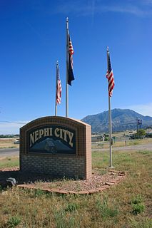
Nephi is a city in Juab County, Utah, United States. It is part of the Provo–Orem metropolitan area. The population was 6,443 at the 2020 census. It is the county seat of Juab County. It was settled by Mormon pioneers in 1851 as Salt Creek, and it acquired its current name in 1882. It is the principal city in the Juab Valley, an agricultural area. Nephi was named after Nephi, son of Lehi, from the Book of Mormon.

Junction, Utah Town in Utah, United States

Junction is a town in and the county seat of Piute County, Utah, United States. The population was 191 at the 2010 census.

Laketown, Utah Town in Utah, United States

Laketown is a town in Rich County, Utah, United States. The population was 248 at the 2010 census. The town is named for nearby Bear Lake.

Fayette, Utah Town in Utah, United States

Fayette is a town in Sanpete County, Utah, United States. The population was 204 at the 2000 census.

Redmond, Utah Town in Utah, United States

Redmond is a town in Sevier County, Utah, United States. The population was 730 at the 2010 census. Redmond was first settled in 1876, and named for red mounds to the west of the town.

Henefer, Utah Town in Utah, United States

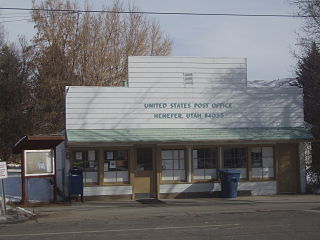
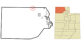
Henefer is a town in Summit County, Utah, United States. It is part of the Salt Lake City, Utah Metropolitan Statistical Area. The population was 766 at the 2010 census.

Vernon, Utah Town in Utah, United States

Vernon is a town in southeastern Tooele County, Utah, United States.

Santaquin, Utah City in Utah, United States

Santaquin is a city in Utah and Juab counties in the U.S. state of Utah. It is part of the Provo–Orem metropolitan area. The population was 13,725 at the 2020 census.

Leeds, Utah Town in Utah, United States

Leeds is a town in Washington County, Utah, United States. The population was 820 at the 2010 census.

New Harmony, Utah Town in Utah, United States

New Harmony is a town in northern Washington County, Utah, United States. The population was 207 at the 2010 census.

Bicknell, Utah Town in Utah, United States

Bicknell is a town along State Route 24 in Wayne County, Utah, United States. As of the 2010 census, the town population was 327.

Huntsville, Utah Town in Utah, United States

Huntsville is a town in Weber County, Utah, United States. The population was 608 at the 2010 census. It is located in Ogden Valley. It is part of the Ogden–Clearfield, Utah Metropolitan Statistical Area, as well as the Ogden Valley census county division.

References

  1. "2019 U.S. Gazetteer Files". United States Census Bureau. Retrieved August 7, 2020.
  2. 1 2 "Population and Housing Unit Estimates". United States Census Bureau. May 24, 2020. Retrieved May 27, 2020.
  3. 1 2 "U.S. Census website". United States Census Bureau . Retrieved January 31, 2008.
  4. "US Board on Geographic Names". United States Geological Survey. October 25, 2007. Retrieved January 31, 2008.
  5. "Rush Valley, UT Population - Census 2010 and 2000 Interactive Map, Demographics, Statistics, Quick Facts - CensusViewer". censusviewer.com. Retrieved February 4, 2019.
  6. Climate Summary for Rush Valley, Utah
  7. "Census of Population and Housing". Census.gov. Retrieved June 4, 2015.
  8. https://www.census.gov/prod/cen1990/cph2/cph-2-46.pdf [ bare URL PDF ]
  9. Census, United States Bureau of the (January 1, 1961). Census of Population: 1960: Characteristics of the population. pt. A and numb. pts. in. U.S. Department of Commerce, Bureau of the Census.
  10. Census, United States Bureau of the; Truesdell, Leon Edgar (January 1, 1931). Fifteenth Census of the United States: 1930: Population ... U.S.GovernmentPrint.Office.