
Persepolis was the ceremonial capital of the Achaemenid Empire. It is situated in the plains of Marvdasht, encircled by southern Zagros mountains, Fars province of Iran. It is one of the key Iranian Cultural heritages. UNESCO declared the ruins of Persepolis a World Heritage Site in 1979.

The Medes were an ancient Iranian people who spoke the Median language and who inhabited an area known as Media between western and northern Iran. Around the 11th century BC, they occupied the mountainous region of northwestern Iran and the northeastern and eastern region of Mesopotamia in the vicinity of Ecbatana. Their consolidation in Iran is believed to have occurred during the 8th century BC. In the 7th century BC, all of western Iran and some other territories were under Median rule, but their precise geographic extent remains unknown.

Ecbatana was an ancient city and the capital of the Median kingdom, making it the first capital of Iran. It later became the summer capital of the Achaemenid and Parthian empires. It was also an important city during the Seleucid and Sasanian empires. It is believed that Ecbatana is located in the Zagros Mountains, the east of central Mesopotamia, on Hagmatana Hill. Ecbatana's strategic location and resources probably made it a popular site even before the 1st millennium BC. Along with Athens in Greece, Rome in Italy and Susa in Khuzestan, Ecbatana is one of the few ancient cities in the world that is still alive and important, representing the current-day Hamadan.

Atropatene, also known as Media Atropatene, was an ancient Iranian kingdom established in c. 323 BC by the Persian satrap Atropates. The kingdom, centered in present-day northern Iran, was ruled by Atropates' descendants until the early 1st-century AD, when the Parthian Arsacid dynasty supplanted them. It was conquered by the Sasanians in 226, and turned into a province governed by a marzban ("margrave"). Atropatene was the only Iranian region to remain under Zoroastrian authority from the Achaemenids to the Arab conquest without interruption, aside from being briefly ruled by the Macedonian king Alexander the Great.

Mithridates I, also known as Mithridates I the Great, was king of the Parthian Empire from 165 BC to 132 BC. During his reign, Parthia was transformed from a small kingdom into a major political power in the Ancient East as a result of his conquests. He first conquered Aria, Margiana and western Bactria from the Greco-Bactrians sometime in 163–155 BC, and then waged war with the Seleucid Empire, conquering Media and Atropatene in 148/7 BC. In 141 BC, he conquered Babylonia and held an official investiture ceremony in Seleucia. The kingdoms of Elymais and Characene shortly afterwards became Parthian vassals. In c. 140 BC, while Mithridates was fighting the nomadic Saka in the east, the Seleucid king Demetrius II Nicator attempted to regain the lost territories; initially successful, he was defeated and captured in 138 BC, and shortly afterwards sent to one of Mithridates I's palaces in Hyrcania. Mithridates I then punished Elymais for aiding Demetrius, and made Persis a Parthian vassal.
Mandane was a Median princess and, later, the queen consort of the Persian king Cambyses I and the mother of Cyrus the Great, the founder of the Achaemenid Empire. The name likely originates from the Old Iranian *Mandanā-, which means “delighting, cheerful”.

Naqsh-e Rostam is an ancient archeological site and necropolis located about 13 km northwest of Persepolis, in Fars Province, Iran. A collection of ancient Iranian rock reliefs are cut into the face of the mountain and the mountain contains the final resting place of four Achaemenid kings, notably king Darius the Great and his son, Xerxes. This site is of great significance to the history of Iran and to Iranians, as it contains various archeological sites carved into the rock wall through time for more than a millennium from the Elamites and Achaemenids to Sassanians. It lies a few hundred meters from Naqsh-e Rajab, with a further four Sassanid rock reliefs, three celebrating kings and one a high priest.

Kharg or Khark Island is a continental island of Iran in the Persian Gulf. The island is 25 km (16 mi) off the coast of Iran and 483 km (300 mi) northwest of the Strait of Hormuz. Its total area is 20 km2 (7.7 sq mi). Administered by the adjacent coastal Bushehr Province, Khark Island provides a sea port for the export of oil and extends Iranian territorial sea claims into the Persian Gulf oil fields. Located on Khark Island is Khark, the only city in the Khark District.

Media is a region of north-western Iran, best known for having been the political and cultural base of the Medes. During the Achaemenid period, it comprised present-day Iranian Azerbaijan, Iranian Kurdistan and western Tabaristan. As a satrapy under Achaemenid rule, it would eventually encompass a wider region, stretching to southern Dagestan in the north. However, after the wars of Alexander the Great, the northern parts were separated due to the Partition of Babylon and became known as Atropatene, while the remaining region became known as Lesser Media.

Drangiana or Zarangiana (Greek: Δραγγιανή, Drangianē; also attested in Old Western Iranian as 𐏀𐎼𐎣, Zraka or Zranka, was a historical region and administrative division of the Achaemenid Empire. This region comprises territory around Hamun Lake, wetlands in endorheic Sistan Basin on the Iran-Afghan border, and its primary watershed Helmand river in what is nowadays southwestern region of Afghanistan.

Commagene was an ancient Greco-Iranian kingdom ruled by a Hellenized branch of the Iranian Orontid dynasty that had ruled over Armenia. The kingdom was located in and around the ancient city of Samosata, which served as its capital. The Iron Age name of Samosata, Kummuh, probably gives its name to Commagene.
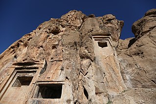
The Essaqwand Rock Tombs are three rock-hewn tombs located 25 km southwest of Harsin in Kermanshah Province, Iran. On top of the middle tomb there is a rock relief of a man with his profile toward the viewers. He is holding his hands in prayers in front of him. There is also a torch and a fire altar in front of him. Behind the fire altar there is another man, holding up something in his hands. The tombs have been attributed to different historical eras including Medes, Achaemenids, Seleucids and Parthians.

Parthia is a historical region located in northeastern Greater Iran. It was conquered and subjugated by the empire of the Medes during the 7th century BC, was incorporated into the subsequent Achaemenid Empire under Cyrus the Great in the 6th century BC, and formed part of the Hellenistic Seleucid Empire after the 4th-century BC conquests of Alexander the Great. The region later served as the political and cultural base of the Eastern Iranian Parni people and Arsacid dynasty, rulers of the Parthian Empire. The Sasanian Empire, the last state of pre-Islamic Iran, also held the region and maintained the seven Parthian clans as part of their feudal aristocracy.
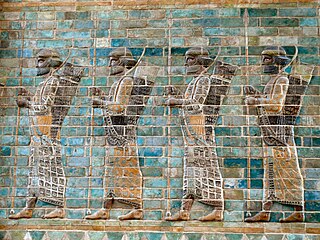
Achaemenid architecture includes all architectural achievements of the Achaemenid Persians manifesting in construction of spectacular cities used for governance and inhabitation, temples made for worship and social gatherings, and mausoleums erected in honor of fallen kings. Achaemenid architecture was influenced by Mesopotamian, Assyrian, Egyptian, Elamite, Lydian, Greek and Median architecture. The quintessential feature of Persian architecture was its eclectic nature with foreign elements, yet producing a unique Persian identity seen in the finished product. Achaemenid architecture is academically classified under Persian architecture in terms of its style and design.

The Achaemenid Empire or Achaemenian Empire, also known as the First Persian Empire, was the ancient Iranian empire founded by Cyrus the Great of the Achaemenid dynasty in 550 BC. Based in modern-day Iran, it was the largest empire by that point in history, spanning a total of 5.5 million square kilometres. The empire spanned from the Balkans and Egypt in the west, West Asia as the base, the majority of Central Asia to the northeast, and the Indus Valley to the southeast.
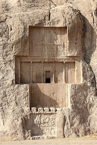
The tomb of Darius the Great (or Darius I) is one of the four tombs for Achaemenid kings at the historical site of Naqsh-e Rostam, located about 12 kilometres (7.5 mi) northwest of Persepolis in Iran. They are all situated at a considerable height above ground-level.

Sasanian art, or Sassanid art, was produced under the Sasanian Empire which ruled from the 3rd to 7th centuries AD, before the Muslim conquest of Persia was completed around 651. In 224 AD, the last Parthian king was defeated by Ardashir I. The resulting Sasanian dynasty would last for four hundred years, ruling modern Iran, Iraq, and much territory to the east and north of modern Iran. At times the Levant, much of Anatolia and parts of Egypt and Arabia were under its control. It began a new era in Iran and Mesopotamia, which in many ways was built on Achaemenid traditions, including the art of the period. Nevertheless, there were also other influences on art of the period that came from as far as China and the Mediterranean.

A rock relief or rock-cut relief is a relief sculpture carved on solid or "living rock" such as a cliff, rather than a detached piece of stone. They are a category of rock art, and sometimes found as part of, or in conjunction with, rock-cut architecture. However, they tend to be omitted in most works on rock art, which concentrate on engravings and paintings by prehistoric peoples. A few such works exploit the natural contours of the rock and use them to define an image, but they do not amount to man-made reliefs. Rock reliefs have been made in many cultures throughout human history, and were especially important in the art of the ancient Near East. Rock reliefs are generally fairly large, as they need to be in order to have an impact in the open air. Most of those discussed here have figures that are over life-size, and in many the figures are multiples of life-size.

The Anubanini petroglyph, also called Sar-e Pol-e Zohab II or Sarpol-i Zohab relief, is a rock relief from the Akkadian Empire period or the Isin-Larsa period and is located in Kermanshah Province, Iran. The rock relief is believed to belong to the Lullubi culture and is located 120 kilometers away from the north of Kermanshah, close to Sarpol-e Zahab. Lullubi reliefs are the earliest rock reliefs of Iran, later ones being the Elamite reliefs of Eshkaft-e Salman and Kul-e Farah.

The Palace of Darius in Susa was a palace complex that was built at the site of Susa, Iran, during the reign of Darius I over the Achaemenid Empire. The construction was conducted parallel to that of Persepolis. Manpower and raw materials from various parts of the Achaemenid Empire contributed to its construction. It was once destroyed by fire and was partially restored later; little has remained from the complex, which is today part of an archaeological site.
 Tomb relief of priest
 Ghale shahin
 Praying at the site
 Kil-e Daud, or David's Tomb


